
The National Oceanic and Atmospheric Administration is an American scientific and regulatory agency charged with forecasting weather, monitoring oceanic and atmospheric conditions, charting the seas, conducting deep-sea exploration, and managing fishing and protection of marine mammals and endangered species in the US exclusive economic zone. The agency is part of the United States Department of Commerce and is headquartered in Silver Spring, Maryland.

The Geostationary Operational Environmental Satellite (GOES), operated by the United States' National Oceanic and Atmospheric Administration (NOAA)'s National Environmental Satellite, Data, and Information Service division, supports weather forecasting, severe storm tracking, and meteorology research. Spacecraft and ground-based elements of the system work together to provide a continuous stream of environmental data. The National Weather Service (NWS) and the Meteorological Service of Canada use the GOES system for their North American weather monitoring and forecasting operations, and scientific researchers use the data to better understand land, atmosphere, ocean, and climate dynamics.

A weather satellite or meteorological satellite is a type of Earth observation satellite that is primarily used to monitor the weather and climate of the Earth. Satellites can be polar orbiting, or geostationary.

The European Organisation for the Exploitation of Meteorological Satellites (EUMETSAT) is an intergovernmental organisation created through an international convention agreed by a current total of 30 European Member States.

Television InfraRed Observation Satellite (TIROS) is a series of early weather satellites launched by the United States, beginning with TIROS-1 in 1960. TIROS was the first satellite that was capable of remote sensing of the Earth, enabling scientists to view the Earth from a new perspective: space. The program, promoted by Harry Wexler, proved the usefulness of satellite weather observation, at a time when military reconnaissance satellites were secretly in development or use. TIROS demonstrated at that time that "the key to genius is often simplicity". TIROS is an acronym of "Television InfraRed Observation Satellite" and is also the plural of "tiro" which means "a young soldier, a beginner".

The National Data Buoy Center (NDBC) is a part of the National Oceanic and Atmospheric Administration's (NOAA) National Weather Service (NWS). NDBC designs, develops, operates, and maintains a network of data collecting buoys and coastal stations. The NDBC is located in southern Mississippi as a tenant at the John C. Stennis Space Center, a National Aeronautics and Space Administration (NASA) facility.

The National Environmental Satellite, Data, and Information Service (NESDIS) was created by the National Oceanic and Atmospheric Administration (NOAA) to operate and manage the United States environmental satellite programs, and manage the data gathered by the National Weather Service and other government agencies and departments.
The Cooperative Institute for Meteorological Satellite Studies (CIMSS) is a research institute where scientists study the use of data from geostationary and polar orbit weather satellites to improve forecasts of weather (including tropical cyclones and severe storms. CIMSS was formed through a Memorandum of Understanding between the University of Wisconsin–Madison, the National Oceanic and Atmospheric Administration and the National Aeronautics and Space Administration. CIMSS parent organization, the Space Science and Engineering Center is a primary developer and operator of environmental satellite technologies.

GOES-1, designated GOES-A and SMS-C prior to entering service, was a weather satellite, developed by the NASA, operated by the United States National Oceanic and Atmospheric Administration (NOAA). It was the first Geostationary Operational Environmental Satellite (GOES) to be launched.
GOES-14, known as GOES-O prior to reaching its operational orbit, is an American weather satellite, which is part of the US National Oceanic and Atmospheric Administration (NOAA)'s Geostationary Operational Environmental Satellite (GOES) system. The spacecraft was built by Boeing and is based on the BSS-601 bus. It is the second of three GOES satellites to use the BSS-601 bus, after GOES-13, which was launched in May 2006.
The Polar-orbiting Operational Environmental Satellite (POES) is a constellation of polar orbiting weather satellites funded by the National Oceanic and Atmospheric Administration (NOAA) and the European Organisation for the Exploitation of Meteorological Satellites (EUMETSAT) with the intent of improving the accuracy and detail of weather analysis and forecasting. The spacecraft were provided by NASA and the European Space Agency (ESA), and NASA's Goddard Space Flight Center oversaw the manufacture, integration and test of the NASA-provided TIROS satellites. The first polar-orbiting weather satellite launched as part of the POES constellation was the Television Infrared Observation Satellite-N (TIROS-N), which was launched on 13 October 1978. The final spacecraft, NOAA-19, was launched on 6 February 2009. The ESA-provided MetOp satellite operated by EUMETSAT utilize POES-heritage instruments for the purpose of data continuity. The Joint Polar Satellite System, which was launched on 18 November 2017, is the successor to the POES Program.

GOES-3, known as GOES-C before becoming operational, was an American geostationary weather and communications satellite. It was originally built for the National Oceanic and Atmospheric Administration as part of the Geostationary Operational Environmental Satellite system, and was launched in June 1978. It was positioned in geostationary orbit, from where it was initially used for weather forecasting in the United States. After ceasing to function as a weather satellite in 1989, it was used as a communications satellite, and spent over thirty-eight years in operation. GOES-3 was decommissioned 29 June 2016 at the Center for Southeastern Tropical Advanced Remote Sensing facility in Miami, Florida.

The Joint Polar Satellite System (JPSS) is the latest generation of U.S. polar-orbiting, non-geosynchronous, environmental satellites. JPSS will provide the global environmental data used in numerical weather prediction models for forecasts, and scientific data used for climate monitoring. JPSS will aid in fulfilling the mission of the U.S. National Oceanic and Atmospheric Administration (NOAA), an agency of the Department of Commerce. Data and imagery obtained from the JPSS will increase timeliness and accuracy of public warnings and forecasts of climate and weather events, thus reducing the potential loss of human life and property and advancing the national economy. The JPSS is developed by the National Aeronautics and Space Administration (NASA) for the National Oceanic and Atmospheric Administration (NOAA), who is responsible for operation of JPSS. Three to five satellites are planned for the JPSS constellation of satellites. JPSS satellites will be flown, and the scientific data from JPSS will be processed, by the JPSS – Common Ground System (JPSS-CGS).
GOES-16, formerly known as GOES-R before reaching geostationary orbit, is the first of the GOES-R series of Geostationary Operational Environmental Satellites (GOES) operated by NASA and the National Oceanic and Atmospheric Administration (NOAA). GOES-16 serves as the operational geostationary weather satellite in the GOES East position at 75.2°W, providing a view centered on the Americas. GOES-16 provides high spatial and temporal resolution imagery of the Earth through 16 spectral bands at visible and infrared wavelengths using its Advanced Baseline Imager (ABI). GOES-16's Geostationary Lightning Mapper (GLM) is the first operational lightning mapper flown in geostationary orbit. The spacecraft also includes four other scientific instruments for monitoring space weather and the Sun.

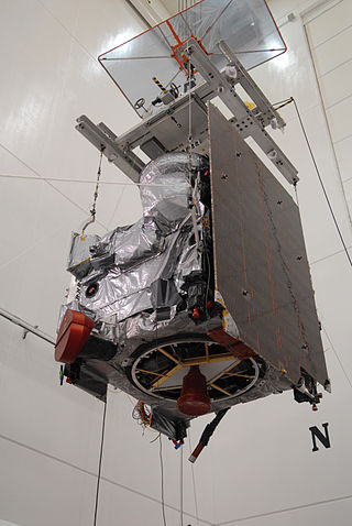
GOES-17 is an environmental satellite operated by the National Oceanic and Atmospheric Administration (NOAA). The satellite is second in the four-satellite GOES-R series. GOES-17 supports the Geostationary Operational Environmental Satellite (GOES) system, providing multi-spectral imaging for weather forecasts and meteorological and environmental research. The satellite was built by Lockheed Martin, based on the A2100A platform, and expected to have a useful life of 15 years. GOES-17 is intended to deliver high-resolution visible and infrared imagery and lightning observations of more than half the globe.
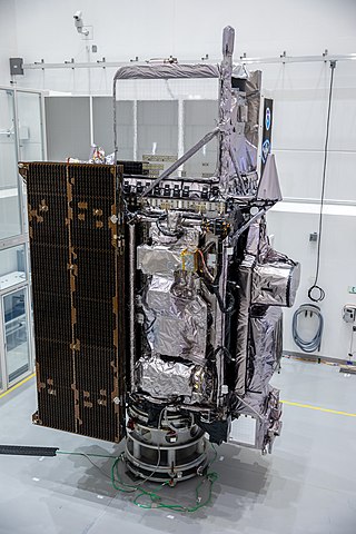
GOES-18 is the third of the "GOES-R Series", the current generation of weather satellites operated by the National Oceanic and Atmospheric Administration (NOAA). The current and next satellites of the Series will extend the availability of the Geostationary Operational Environmental Satellite (GOES) satellite system until 2037. The satellite is built by Lockheed Martin in Littleton, Colorado. It is based on the A2100A satellite bus and will have an expected useful life of 15 years.

NOAA-21, designated JPSS-2 prior to launch, is the second satellite in National Oceanic and Atmospheric Administration (NOAA)'s latest series of U.S. polar-orbiting, non-geosynchronous, environmental satellites, known as the Joint Polar Satellite System (JPSS). Launched on November 10, 2022, along with LOFTID, NOAA-21 now operates in the same orbit as NOAA-20 and Suomi NPP. It travels in a polar orbit, crossing the equator approximately 14 times a daily, and provides complete global coverage twice a day.
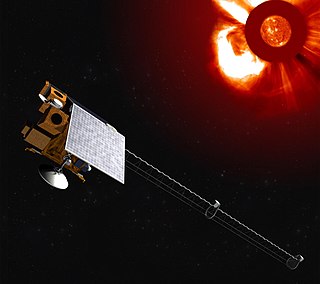
Vigil, formerly known as Lagrange, is a space weather mission developed by the European Space Agency. The mission will provide the ESA Space Weather Office with instruments able to monitor the Sun, its solar corona and interplanetary medium between the Sun and Earth, to provide early warnings of increased solar activity, to identify and mitigate potential threats to society and ground, airborne and space based infrastructure as well as to allow 4 to 5 days space weather forecasts. To this purpose the Vigil mission will place for the first time a spacecraft at Sun-Earth Lagrange point 5 (L5) from where it would get a 'side' view of the Sun, observing regions of solar activity on the solar surface before they turn and face Earth.
GOES-19 is a weather satellite, the fourth and last of the GOES-R series of satellites operated by the National Oceanic and Atmospheric Administration (NOAA). The GOES-R series will extend the availability of the Geostationary Operational Environmental Satellite (GOES) system until 2036. The satellite is built by Lockheed Martin, based on the A2100 platform.
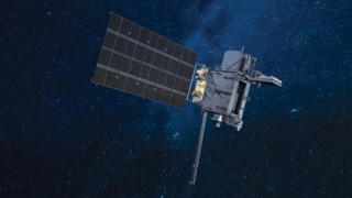
Space Weather Follow On-Lagrange 1 (SWFO-L1) is a future spacecraft mission planned to monitor signs of solar storms, which may pose harm to Earth's telecommunication network. The spacecraft will be operated by the National Oceanic and Atmospheric Administration (NOAA), with launch scheduled for 29 April 2025. It is planned to be placed at the Sun–Earth L1 Lagrange point, a location between the Earth and the Sun. This will allow SWFO-L1 to continuously watch the solar wind and energetic particles heading for Earth. SWFO-L1 is an ESPA Class Spacecraft, sized for launch on an Evolved Expendable Launch Vehicle Secondary Payload Adapter (ESPA) Grande ring in addition to the rocket's primary payload. The spacecraft's Solar Wind Instrument Suite (SWIS) which includes three instruments will monitor solar wind, and the Compact Coronagraph (CCOR) will monitor the Sun's surroundings to image coronal mass ejection (CME). A CME is a large outburst of plasma sent from the Sun towards interplanetary space.
