Gerald Desmond Bridge

Last updated

Gerald Desmond Bridge
Gerald Desmond Bridge.jpg
The 1968 Gerald Desmond Bridge (pictured in 2008) spans the Back Channel, connecting Long Beach with Terminal Island.
Coordinates 33°45′52″N118°13′16″W / 33.76444°N 118.22111°W / 33.76444; -118.22111 Coordinates: 33°45′52″N118°13′16″W / 33.76444°N 118.22111°W / 33.76444; -118.22111
Carries5 lanes of Ocean Blvd between California 47.svg SR 47 and I-710 (1961).svg I-710
Crosses Back Channel
Locale Terminal Island and Long Beach, California
Named for Gerald Desmond
Owner Port of Long Beach
NBI53C0065
Preceded by1944 pontoon bridge
Followed by Long Beach International Gateway (cable-stayed span)
Characteristics
Design through arch bridge
MaterialSteel
Total length5,134 ft (1,565 m)
Width67.3 ft (21 m)
Height250 ft (76 m)
Longest span410 ft (125 m) [1]
Clearance above 18.4 ft (6 m)
Clearance below 155 ft (47 m)
History
DesignerMoffatt & Nichol
Constructed by Bethlehem Steel
Construction startOctober 19, 1965
Construction endJune 1968
Construction costUS$12,700,000(equivalent to $98,960,000 in 2021)
Rebuilt1995–2000
ClosedOctober 2, 2020
Replaces1944 pontoon bridge
Replaced byCable-stayed span
Statistics
Daily traffic 62,057 (2012)
Location
Gerald Desmond Bridge

The Gerald Desmond Bridge was a 1968 through arch bridge that carried five lanes of Ocean Boulevard from Interstate 710 in Long Beach, California, west across the Back Channel to Terminal Island. The bridge was named after Gerald Desmond, a prominent civic leader and former city attorney for the City of Long Beach. In October 2020, a new cable-stayed bridge named Long Beach International Gateway replaced the old Gerald Desmond Bridge due to insufficient vertical clearance for shipping, Demolition of the old bridge is expected to be completed in 2023. [2]

Contents

Historical crossings

Prior to 1944, the only road access to Terminal Island was via Badger Avenue (later Henry Ford Avenue, after an assembly plant that was built on the island) over the Henry Ford Bridge.

1944 pontoon bridge

Back Channel, the Los Angeles River and downtown Long Beach, prior to the construction of the pontoon bridge California - Long Beach - NARA - 23934445.jpg
Back Channel, the Los Angeles River and downtown Long Beach, prior to the construction of the pontoon bridge

The first bridge linking the eastern end of Terminal Island and Long Beach was an unnamed "temporary" pontoon bridge constructed during World War II to accommodate traffic resulting from the expansion of the Long Beach Naval Shipyard. The pontoon bridge was intended to last six months, but was not replaced until 1968, 24 years after it had opened. Depending on the level of the tide, road traffic had to descend 17 to 25 feet (5.2 to 7.6 m) below the level on the shore. When marine traffic required the bridge to open, traffic delays of up to 15 minutes could occur. [3] An estimated seven people died after driving off the pontoon bridge. [3] [4]

1968 through-arch

The 1968 through-arch bridge was designed by Moffatt & Nichol [5] Engineers and was constructed by Bethlehem Steel [6] as a replacement for the World War II-era pontoon bridge. [7] Gerald Desmond served as City Attorney for Long Beach and played a significant role in obtaining tideland oil funds which helped finance the bridge that would later bear his name. Desmond died in office at age 48 of kidney cancer. [8] One year after Desmond's death in January 1964, groundbreaking for the construction of the new bridge occurred on October 19, 1965, and it was completed in June 1968. Desmond's son, also named Gerald, sank the final "golden" bolt. [8]

Design

It has a 527-foot-long (161 m) suspended main span and a 155-foot (47 m) vertical clearance spanning the Cerritos Channel. The western terminus of the bridge is on the east side of Terminal Island; the eastern terminus is close to downtown Long Beach. The bridge separates the inner harbor (north of the bridge) of the Port of Long Beach from the middle harbor.

Seismic retrofitting

The bridge was retrofitted with vibration isolators and additional foundation work (widening footings and adding pilings) was performed to upgrade the seismic resistance from 1996–97 prior to the transfer of ownership from the Port of Long Beach to Caltrans. [9]

Issues

At the time of its completion in 1968, traffic was projected to be modest and mainly limited to workers commuting to jobs at the Long Beach Naval Shipyard. When the Long Beach NSY was closed in 1997, that land was converted and served as home to one of the busiest container terminals in the United States, resulting in greater cargo truck and marine traffic. By some estimates, truck traffic across the bridge tripled in the years following the closure of the Long Beach NSY. [10] By 2010, the 155-foot (47 m) vertical clearance of the 1968 bridge was one of the lowest for a commercial seaport, especially at the Port of Long Beach, which remains one of the busiest container ports in the United States. [11] In addition, the bridge was not designed for the traffic it carried (62,000 vehicles daily in 2012), and the added stress was causing pieces of concrete to fall from the bridge's underside, forcing the Port of Long Beach to install nylon mesh "diapers" in 2004 to catch these chunks. [10] Studies to widen the bridge were funded in 1987. [12] Caltrans rated the structural sufficiency of the Desmond Bridge at 43 points out of possible 100 in 2007. [13]

Also, since the 1968 bridge roadway lacks emergency/breakdown lanes, multiple lanes would be shut down in the event of an accident, snarling traffic. [14] Other deficiencies cited include the steep approach grades (5.5 percent on the west side and 6 percent on the east side) [15]

Competition in the marine shipping industry meant shipping companies were interested in boosting operating efficiency, mainly by building ever-larger container ships. The Gerald Desmond Bridge became a barrier for large ships entering the Inner Harbor at Long Beach, with its restrictive 155-foot (47 m) vertical clearance. This restrictive vertical clearance was cited as a factor in an observed drop in the Port of Long Beach's share of United States container imports. According to U.S. census data, the ports of Long Beach and Los Angeles handled 32% of U.S. container imports in 2013, down from 39% in 2002. [16] Port officials estimated that 10% of all waterborne cargo in the United States passed under the Desmond Bridge (either going to or coming from the Ports of Long Beach and Los Angeles) in 2004, [10] raising the estimate to 15% by 2010. [13]

In March 2012, the insufficient vertical clearance of the bridge prevented passage of the 12,562  TEU MSC Fabiola , the largest container ship ever to enter the Port of Long Beach. The height restriction prevented the ship from docking at the Mediterranean Shipping Company (MSC) dock; it docked at the Hanjin terminal instead. [17]

View of the old Gerald Desmond Bridge from the north, looking south-southeast. Netting is visible on the bottom of the truss spans flanking the main arch span, serving to catch chunks of decaying concrete that occasionally fall from the structure. Gerald Desmond Bridge (old) from north looking south-southeast crop.jpg
View of the old Gerald Desmond Bridge from the north, looking south-southeast. Netting is visible on the bottom of the truss spans flanking the main arch span, serving to catch chunks of decaying concrete that occasionally fall from the structure.

Cable-stayed replacement

The 1968 steel arch bridge developed numerous issues (detailed above), and the Port of Long Beach suggested it would be more economical to replace the bridge. After several years of studies, a cable-stayed bridge with 205 feet (62 m) of vertical clearance to be built north of the existing bridge was identified as the preferred alternative in the final environmental impact report (2010 FEIR). [15] The new bridge will allow access to the port for the tallest container ships, and will be the first long-span cable-stayed bridge in California, and the first and only cable-stayed bridge in the Los Angeles metropolitan area. [18] For the bridge to be so tall, long approaches will be required to allow trucks to cross. [19] A joint venture of Parsons Transportation Group and HNTB performed preliminary engineering for the main span and the approaches. Earlier reports had studied and discarded various alternatives, including an alternative alignment with a new bridge south of the existing bridge, rehabilitation of the existing bridge, and a tunnel instead of an elevated bridge. [15]

The 1944 pontoon bridge was featured in a chase scene appearing in the 1963 film It's a Mad, Mad, Mad, Mad World . [3] [20]

The 1968 arch bridge had a featured role in the film Head , featuring rock group The Monkees, released in 1968. The first scene of the film features the actual dedication ceremony for the bridge, which is interrupted by the Monkees running into the middle of the ceremony and Micky Dolenz jumping off the bridge. At the conclusion of the film, the Monkees return to the bridge and each of them jumps from it.

Elysian Freeway Bridge, based on the 1968 arch bridge, is also featured in the 2013 video game Grand Theft Auto V. It carries the Elysian Fields Freeway in-game.

Conceptual view comparing the profiles of the 2020 (cable-stayed) and 1968 (through arch) bridges. Note taller clearance below for 2020 bridge: 205 ft (62 m) above water line, compared to 155 ft (47 m). Gerald Desmond Bridge & Replacement.svg
Conceptual view comparing the profiles of the 2020 (cable-stayed) and 1968 (through arch) bridges. Note taller clearance below for 2020 bridge: 205 ft (62 m) above water line, compared to 155 ft (47 m).

See also

Related Research Articles

<span class="mw-page-title-main">San Francisco–Oakland Bay Bridge</span> Complex of bridges spanning San Francisco Bay

The San Francisco–Oakland Bay Bridge, known locally as the Bay Bridge, is a complex of bridges spanning San Francisco Bay in California. As part of Interstate 80 and the direct road between San Francisco and Oakland, it carries about 260,000 vehicles a day on its two decks. It has one of the longest spans in the United States.

<span class="mw-page-title-main">Port of Los Angeles</span> Harbor in Los Angeles, California

The Port of Los Angeles is a seaport managed by the Los Angeles Harbor Department, a unit of the City of Los Angeles. It occupies 7,500 acres (3,000 ha) of land and water with 43 miles (69 km) of waterfront and adjoins the separate Port of Long Beach. Promoted as "America's Port", the port is located in San Pedro Bay in the San Pedro and Wilmington neighborhoods of Los Angeles, approximately 20 miles (32 km) south of downtown.

<span class="mw-page-title-main">Bayonne Bridge</span> Bridge between New Jersey and New York

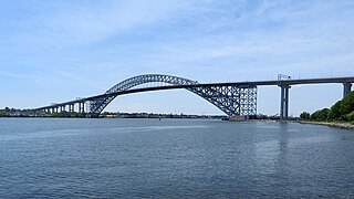
Bayonne Bridge is an arch bridge spanning the Kill Van Kull and connecting Bayonne, New Jersey with Staten Island in New York City. It carries New York State Route 440 (NY 440) and New Jersey Route 440. It is the sixth-longest steel arch bridge in the world, and it was the longest in the world at the time of its completion. The bridge is also one of four connecting New Jersey with Staten Island; the other two roadway bridges are the Goethals Bridge in Elizabeth and Outerbridge Crossing in Perth Amboy, and the rail-only span is the Arthur Kill Vertical Lift Bridge, all of which cross the Arthur Kill.

<span class="mw-page-title-main">Interstate 710 and State Route 710 (California)</span> Interstate and state highway in California

Route 710, consisting of the non-contiguous segments of State Route 710 (SR 710) and Interstate 710 (I-710), is a major north–south state highway and auxiliary Interstate Highway in the Los Angeles metropolitan area of the U.S. state of California. Also called the Los Angeles River Freeway prior to November 18, 1954, the highway was initially planned to connect Long Beach and Pasadena, but a gap in the route exists from Alhambra to Pasadena through South Pasadena due to community opposition to its construction.

<span class="mw-page-title-main">Long Beach Naval Shipyard</span>

The Long Beach Naval Shipyard, which closed in 1997, was located on Terminal Island between the city of Long Beach and the San Pedro district of Los Angeles, approximately 23 miles south of the Los Angeles International Airport. The primary role of NSY Long Beach at the time of its closure was overhaul and maintenance of conventionally-powered US Navy surface ships, but it also had served as the homeport for several auxiliary ships during its operating history.

<span class="mw-page-title-main">Richmond–San Rafael Bridge</span> Bridge crossing the San Francisco Bay

The Richmond–San Rafael Bridge is the northernmost of the east–west crossings of the San Francisco Bay in California, USA. Officially named after California State Senator John F. McCarthy, it bridges Interstate 580 from Richmond on the east to San Rafael on the west. It opened in 1956, replacing ferry service by the Richmond–San Rafael Ferry Company.

<span class="mw-page-title-main">Port of Oakland</span> Container ship facility in Oakland, California

The Port of Oakland is a major container ship facility located in Oakland, California, in the San Francisco Bay. It was the first major port on the Pacific Coast of the United States to build terminals for container ships. As of 2011 it was the fifth busiest container port in the United States, behind Long Beach, Los Angeles, Newark, and Savannah. Development of an intermodal container handling system in 2002 after over a decade of planning and construction positions the Port of Oakland for further expansion of the West Coast freight market share. In 2019 it ranked 8th in the United States in the category of containers.

<span class="mw-page-title-main">Burlington Bay James N. Allan Skyway</span> Highway bridge across Hamilton Harbour in Hamilton and Burlington, Ontario, Canada

The Burlington Bay James N. Allan Skyway, originally called the Burlington Bay Skyway and simply known as the Burlington Skyway, is a pair of high-level freeway bridges spanning the Burlington Bay Canal. The Skyway, as it is locally known, is located in Hamilton and Burlington, Ontario, Canada, and is part of the Queen Elizabeth Way (QEW) highway linking Fort Erie with Toronto.

<span class="mw-page-title-main">San Diego–Coronado Bridge</span> Bridge in San Diego and Coronado, California

The San Diego–Coronado Bridge, locally referred to as the Coronado Bridge, is a prestressed concrete/steel girder bridge fixed-link, crossing over San Diego Bay in the United States, linking San Diego with Coronado, California. The bridge is signed as part of State Route 75.

<span class="mw-page-title-main">Vincent Thomas Bridge</span> Suspension bridge in Los Angeles, California, United States

The Vincent Thomas Bridge is a 1,500-foot-long (460 m) suspension bridge, crossing Los Angeles Harbor in Los Angeles, California, linking San Pedro with Terminal Island. It is the only suspension bridge in the Greater Los Angeles area. The bridge is part of State Route 47, which is also known as the Seaside Freeway. The bridge opened in 1963 and is named for California Assemblyman Vincent Thomas of San Pedro, who championed its construction. It was the first welded suspension bridge in the United States and is now the fourth-longest suspension bridge in California and the 76th-longest span in the world. The clear height of the navigation channel is approximately 185 feet (56 m); it is the only suspension bridge in the world supported entirely on piles.

<span class="mw-page-title-main">Port of Long Beach</span> Container port near Los Angeles, California

The Port of Long Beach, also known as the Harbor Department of the City of Long Beach, is a container port in the United States, which adjoins Port of Los Angeles. Acting as a major gateway for US–Asian trade, the port occupies 3,200 acres (13 km2) of land with 25 miles (40 km) of waterfront in the city of Long Beach, California. The Port of Long Beach is located less than two miles (3 km) southwest of Downtown Long Beach and approximately 25 miles (40 km) south of Downtown Los Angeles. The seaport generates approximately $100 billion per year in trade and employs more than 316,000 people in Southern California. As of 2022, the port, together with the adjoining Port of Los Angeles, are considered the least efficient ports on the planet.

<span class="mw-page-title-main">Stonecutters Bridge</span> Bridge in Hong Kong

Stonecutters Bridge is a high level cable-stayed bridge spanning the Rambler Channel in Hong Kong, connecting Nam Wan Kok, Tsing Yi to Stonecutters Island. The bridge deck was completed on 7 April 2009, and opened to traffic on 20 December that year. The bridge was the second-longest cable-stayed span in the world at the time of its completion.

<span class="mw-page-title-main">Arthur Kill Vertical Lift Bridge</span> Bridge between New Jersey and New York

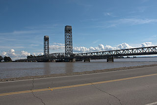
The Arthur Kill Vertical Lift Railroad Bridge is a rail vertical-lift bridge connecting Elizabethport, New Jersey and the Howland Hook Marine Terminal on Staten Island, New York, United States. The bridge was built by the Baltimore and Ohio Railroad in 1959 to replace the Arthur Kill Bridge, a swing bridge opened in 1890. It contains a single track that is used mainly to carry garbage out of New York City, as well as to transport freight to destinations in western Staten Island. The bridge parallels the Goethals Bridge, which carries Interstate 278. It has the longest lift span of any vertical-lift bridge in the world, with two 215-foot (66 m) towers and a 558-foot (170 m) truss span that allows a 500-foot (152 m) channel. It clears mean high water by 31 feet (9.45 m) when closed and 135 feet (41 m) when lifted.

<span class="mw-page-title-main">Commodore Schuyler F. Heim Bridge</span> Bridge in Wilmington, California

The Commodore Schuyler F. Heim Bridge was a vertical-lift bridge in the Port of Los Angeles. Dedicated on January 10, 1948, the bridge allowed State Route 47 to cross over the Cerritos Channel. Named after Schuyler F. Heim, who was in command of the Naval Air Station on Terminal Island in 1942, the bridge was one of the largest vertical-lift bridges on the West Coast. At the time of its opening, it was the highest in the country with the deck weighing about 820 short tons. Its towers are 186 feet (57 m) tall above the roadway deck and about 236 feet (72 m) tall when measured from the water level at high water. The bridge was decommissioned on October 12, 2015 and replaced by a new, six-lane fixed-span bridge in order to meet current safety and earthquake standards. A replacement bridge, tentatively titled State Route 47 Schuyler Heim Bridge Replacement, was completed in September 2020.

Tranebergsbron is a double arch bridge in central Stockholm, Sweden. Stretching over the strait Tranebergssund it connects the major island Kungsholmen to the western suburb Bromma. It carries a road and metro tracks.

<span class="mw-page-title-main">Port of Southampton</span> Passenger and cargo port in Southampton, England

The Port of Southampton is a passenger and cargo port in the central part of the south coast of England. The modern era in the history of the Port of Southampton began when the first dock was inaugurated in 1843. The port has been owned and operated by Associated British Ports since 1982, and is the busiest cruise terminal and second largest container port in the UK. The volume of port traffic categorises Southampton as a Medium-Port City globally.

<span class="mw-page-title-main">Rio Vista Bridge</span> Bridge in California, U.S.

The Rio Vista Bridge is a continuous truss span with a vertical-lift bridge in the middle which carries California State Route 12 across the Sacramento River at Rio Vista, California. The present bridge was completed in 1960 and is one of several moveable bridges spanning rivers in the Sacramento–San Joaquin River Delta. It is named after Helen Madere, who served as vice-mayor of Rio Vista. As of 2013 the bridge carries approximately 21,000 cars per day.

<span class="mw-page-title-main">Queensway Twin Bridges</span> Bridge in Long Beach, California

The Queensway Twin Bridges connect downtown Long Beach with the outer Port of Long Beach. They are the southernmost crossing of the Los Angeles River, near the mouth of the river, where it empties into Queensway Bay, and they are the primary arterial link between Long Beach and RMS Queen Mary. The bridges were completed in June 1970 and opened on October 5, 1970.

<span class="mw-page-title-main">Long Beach International Gateway</span> Cable-stayed bridge in Long Beach, California, United States

The Long Beach International Gateway is a cable-stayed bridge that carries six lanes of Interstate 710 and a bicycle/pedestrian path in Long Beach, California, west across the Back Channel to Terminal Island. The bridge replaced the Gerald Desmond Bridge, which was completed in 1968 and named after Gerald Desmond, a prominent civic leader and a former city attorney for the City of Long Beach.

<span class="mw-page-title-main">Naval Operating Base Terminal Island</span> World War II Naval Base in Los Angeles

Naval Operating Base Terminal Island, was United States Navy base founded on 25 September 1941 to support the World War II efforts in the Pacific War. Naval Operating Base Terminal Island was founded by combining Naval Facilities in cities of San Pedro, Long Beach and Wilmington, California under one command. Much of the base was on the man-made Terminal Island, and harbor in San Pedro Bay. The harbor was made through the construction of a large breakwater system.

References

  1. "Crews lower main span of Gerald Desmond as demolition begins on 54-year-old bridge". Long Beach Business Journal.
  2. Brandon Richardson (July 30, 2021). "Gerald Desmond Bridge to be fully demolished by October 2023". Long Beach Business Journal. Retrieved November 30, 2021.
  3. 1 2 3 Harvey, Steve (October 3, 2010). "Bridge is afloat on the pages of history". Los Angeles Times. Retrieved November 21, 2016.
  4. Waldie, D. J. (June 3, 2013). "The Bridges of Terminal Island". KCET. Retrieved November 21, 2016.
  5. Husky, Brian. "Rail & Bridge Services". M&N. Archived from the original on August 4, 2014.
  6. "Slender but sturdy". Palos Verdes Peninsula News. February 1, 1967. Retrieved December 6, 2016. SLENDER BUT STURDY - Slender spans of steel connect the lofty piers of the Gerald Desmond bridge, marking near completion of the eastern approach which will form the vital link between the Port of Long Beach and Terminal Island. This consists of a fabricated steel plate girder structure extending 1813 ft. from ground level to a height of 141 ft. Bethlehem Steel bridgemen are now erecting the bridge's east approach anchor arms which will support the cantilevered portion, or main channel span. To date, Bethlehem, prime contractor for the $12.7 million project, has erected over 2400 tons of steel for the east approach. Shorter suspended girders were fabricated at Bethlehen's Torrance works. The new bridge will be a three-span, tied-arch truss with welded-plate-girder approaches and an overall length of 6000 feet. Highest part of the arch will be 250 feet with the main deck clearing the entrance channel by 160 feet. It will link the Ocean Boulevard bridge, which crosses the Los Angeles River with Seaside Boulevard on Terminal Island.
  7. Baldwin, Jack O. (June 7, 1968). "Desmond Bridge is Dedicated". Long Beach Independent. Retrieved December 5, 2016.
  8. 1 2 Haldane, David (June 20, 1985). "Son of a Bridge, If It Isn't Gerald Desmond". Los Angeles Times. Retrieved November 21, 2016.
  9. "Seismic Work Will Force Weekend Closure of Desmond Bridge on Terminal Island". Los Angeles Times. April 24, 1997. Retrieved December 6, 2016.
  10. 1 2 3 Daniels, Cynthia (March 25, 2004). "Terminal Island Cargo Has Outgrown Old Bridge". Los Angeles Times. Retrieved November 21, 2016.
  11. Ceasar, Stephen (November 23, 2010). "Long Beach bridge at the end of its lifespan". Los Angeles Times. Retrieved November 21, 2016.
  12. Murphy, Dean (May 28, 1987). "Overpasses, Bridge Work Proposed in Harbor Area". Los Angeles Times. Retrieved December 6, 2016.
  13. 1 2 White, Ronald D. (February 9, 2010). "Bridge poses a tight squeeze for cargo ships". Los Angeles Times. Retrieved November 21, 2016.
  14. White, Ronald D. (February 5, 2010). "Plan to replace bridge at Port of Long Beach progresses". Los Angeles Times. Retrieved November 21, 2016.
  15. 1 2 3 Parsons–HNTB Joint Venture (July 2010). Gerald Desmond Bridge Replacement Project: Final Environmental Impact Report / Environmental Assessment & Application Summary Report (PDF) (Report). Port of Long Beach and Caltrans. Retrieved November 21, 2016.
  16. Kirkham, Chris; Khouri, Andrew (June 2, 2015). "LA., Long Beach ports losing to rivals amid struggle with giant ships". Los Angeles Times. Retrieved November 21, 2016.
  17. Porter, Janet (March 6, 2012). "Long Beach prepares for Pacific ultra-large boxship switch". Lloyd's List. Lloyd's. Retrieved March 22, 2012.
  18. Ortega, Norma (October 19–20, 2016). "Supplemental funds allocation for Gerald Desmond Bridge design-build project resolution FA-16-07" (PDF). Letter to Chair and Commissioners, California Transportation Commission. Retrieved November 21, 2016.
  19. Stocking, Angus (June 18, 2014), "Innovative System Ensures Vertical Alignment of Gerald Desmond Bridge", Point of Beginning, Troy, Michigan: BNP Media
  20. Grobaty, Tim (February 23, 2011). "Ready for action". Long Beach Press-Telegram. Retrieved November 21, 2016.