Gettysburg, South Dakota

Last updated

Gettysburg, South Dakota
Stocker Blacksmith Shop NRHP 96000744 Potter County, SD.jpg
Stocker Blacksmith Shop, listed on the National Register of Historic Places
Nickname: 
Gettysburg "Where the Battle Wasn't"
Motto: 
"Come Play On The Prairie"
Potter County South Dakota Incorporated and Unincorporated areas Gettysburg Highlighted.svg
Location in Potter County and the state of South Dakota
Coordinates: 45°00′22″N99°57′14″W / 45.00611°N 99.95389°W / 45.00611; -99.95389
CountryUnited States
State South Dakota
County Potter
Incorporated1907 [1]
Government
  MayorAdam Roseland
Area
[2]
  Total1.92 sq mi (4.97 km2)
  Land1.92 sq mi (4.97 km2)
  Water0.00 sq mi (0.00 km2)
Elevation
[3]
2,064 ft (629 m)
Population
 (2020) [4]
  Total1,104
  Density574.70/sq mi (221.92/km2)
Time zone UTC−6 (Central (CST))
  Summer (DST) UTC−5 (CDT)
ZIP code
57442
Area code 605
FIPS code 46-24260 [5]
GNIS feature ID1267404 [3]
Website cityofgettysburgsd.com

Gettysburg is a city and county seat of Potter County, South Dakota, United States, [6] along the 45th parallel. The population was 1,104 at the 2020 census. [7]

Contents

History

Gettysburg was platted in 1884. [8] The city was named in commemoration of the Battle of Gettysburg. [8] A large share of the early settlers were Civil War veterans of the Union Army. [9] Gettysburg was once home to Gettysburg Air Force Station which closed in 1968.

Geography

According to the United States Census Bureau, the city has a total area of 1.89 square miles (4.90 km2), all land. [10]

Climate

With a precipitation slightly above 465 mm, [11] the city can be considered the watershed between the dry climates of the American West to the humid climates of the American East, although closer to the former, with a center characterized by the steppes and medium precipitation marking the east limit of the group B of dry climates (except for the hot versions on the subcontinent) for the 99.9 °W meridian. [12] From the climatic map of the University of Melbourne, Gettysburg is the easternmost city in North America with a semi-arid cold climate (Köppen: Bsk). [12] [13] The average high temperature is 12.7 °C and the low average is -0.4 °C, which makes temperatures below the freezing point predominate for at least part of the year. The annual average snow is of 99 cm. For the official data of the NOAA/Weather Service: the average annual precipitation is of 501 mm, by which it strengthens its role of confluence. The wettest months range from May to July ranging from 72 to 88 mm and the driest January (only 9 mm). The amount of snow is average in proportion to its cold weather surpassing the 20 cm between February and March. [14]

Climate data for Gettysburg, South Dakota (1991−2020 normals, extremes 1901−present)
MonthJanFebMarAprMayJunJulAugSepOctNovDecYear
Record high °F (°C)64
(18)
70
(21)
85
(29)
97
(36)
104
(40)
108
(42)
114
(46)
111
(44)
107
(42)
94
(34)
80
(27)
69
(21)
114
(46)
Mean daily maximum °F (°C)24.8
(−4.0)
29.1
(−1.6)
41.5
(5.3)
55.8
(13.2)
67.5
(19.7)
77.7
(25.4)
84.3
(29.1)
83.0
(28.3)
73.8
(23.2)
58.0
(14.4)
41.8
(5.4)
28.9
(−1.7)
55.5
(13.1)
Daily mean °F (°C)15.1
(−9.4)
19.2
(−7.1)
30.9
(−0.6)
43.9
(6.6)
55.7
(13.2)
66.2
(19.0)
72.0
(22.2)
70.4
(21.3)
61.0
(16.1)
46.3
(7.9)
31.6
(−0.2)
19.5
(−6.9)
44.3
(6.8)
Mean daily minimum °F (°C)5.3
(−14.8)
9.3
(−12.6)
20.3
(−6.5)
32.0
(0.0)
43.8
(6.6)
54.6
(12.6)
59.8
(15.4)
57.8
(14.3)
48.2
(9.0)
34.7
(1.5)
21.3
(−5.9)
10.1
(−12.2)
33.1
(0.6)
Record low °F (°C)−33
(−36)
−34
(−37)
−28
(−33)
0
(−18)
16
(−9)
32
(0)
38
(3)
34
(1)
19
(−7)
1
(−17)
−17
(−27)
−32
(−36)
−34
(−37)
Average precipitation inches (mm)0.29
(7.4)
0.57
(14)
0.66
(17)
1.86
(47)
3.03
(77)
3.45
(88)
3.01
(76)
2.49
(63)
2.01
(51)
1.89
(48)
0.51
(13)
0.40
(10)
20.17
(512)
Average snowfall inches (cm)6.8
(17)
10.6
(27)
5.5
(14)
4.5
(11)
0.3
(0.76)
0.0
(0.0)
0.0
(0.0)
0.0
(0.0)
0.0
(0.0)
1.3
(3.3)
3.0
(7.6)
6.7
(17)
38.7
(98)
Average precipitation days (≥ 0.01 in)4.05.35.27.99.49.67.97.47.06.74.14.278.7
Average snowy days (≥ 0.1 in)3.94.52.11.30.10.00.00.00.00.51.53.517.4
Source: NOAA [15] [16]

Demographics

Historical population
CensusPop.Note
1910 936
1920 9511.6%
1930 1,40047.2%
1940 1,324−5.4%
1950 1,55517.4%
1960 1,95025.4%
1970 1,915−1.8%
1980 1,623−15.2%
1990 1,510−7.0%
2000 1,352−10.5%
2010 1,162−14.1%
2020 1,104−5.0%
U.S. Decennial Census [17]
2018 Estimate [18] [4]

2010 census

As of the census [5] of 2010, there were 1,162 people, 534 households, and 310 families living in the city. The population density was 614.8 inhabitants per square mile (237.4/km2). There were 617 housing units at an average density of 326.5 per square mile (126.1/km2). The racial makeup of the city was 97.3% White, 0.3% African American, 1.2% Native American, 0.2% Asian, and 1.0% from two or more races. Hispanic or Latino of any race were 0.6% of the population.

There were 534 households, of which 21.9% had children under the age of 18 living with them, 49.1% were married couples living together, 5.1% had a female householder with no husband present, 3.9% had a male householder with no wife present, and 41.9% were non-families. 37.8% of all households were made up of individuals, and 21.8% had someone living alone who was 65 years of age or older. The average household size was 2.08 and the average family size was 2.74.

The median age in the city was 50.3 years. 19.7% of residents were under the age of 18; 4.7% were between the ages of 18 and 24; 18.1% were from 25 to 44; 29.7% were from 45 to 64; and 27.6% were 65 years of age or older. The gender makeup of the city was 48.4% male and 51.6% female.

2000 census

As of the census [5] of 2000, there were 1,352 people, 588 households, and 365 families living in the city. The population density was 725.1 inhabitants per square mile (280.0/km2). There were 683 housing units at an average density of 366.3 per square mile (141.4/km2). The racial makeup of the city was 97.93% White, 1.26% Native American, 0.07% Asian, and 0.74% from two or more races. Hispanic or Latino of any race were 0.15% of the population.

There were 588 households, out of which 26.9% had children under the age of 18 living with them, 52.9% were married couples living together, 6.0% had a female householder with no husband present, and 37.9% were non-families. 36.4% of all households were made up of individuals, and 20.6% had someone living alone who was 65 years of age or older. The average household size was 2.21 and the average family size was 2.88.

In the city, the population was spread out, with 23.9% under the age of 18, 4.0% from 18 to 24, 21.8% from 25 to 44, 24.3% from 45 to 64, and 26.0% who were 65 years of age or older. The median age was 45 years. For every 100 females, there were 92.0 males. For every 100 females age 18 and over, there were 87.8 males.

As of 2000 the median income for a household in the city was $30,469, and the median income for a family was $37,763. Males had a median income of $26,316 versus $16,979 for females. The per capita income for the city was $16,516. About 7.9% of families and 10.7% of the population were below the poverty line, including 14.4% of those under age 18 and 11.3% of those age 65 or over.

Controversy over Confederate Flag

In June 2020, in the midst of national and international protests in opposition to racism following the murder of George Floyd, Gettysburg became the focus of controversy regarding the presence of the Confederate battle flag on the patch of the city's police department. The patch featured overlapping equal-sized U.S. and Confederate flags and a civil-war era cannon along with the city's name, in a nod to the city's namesake, Gettysburg, Pennsylvania, site of the famous battle. [19] The historical reference logo for the police emblem and uniform patch was designed in 2009. [20] George Floyd's uncle resides in Gettysburg and advocated for the logo to change for the two-person police force. [21] The police patch and logo were removed in July 2020. [22] [23]

See also

Related Research Articles

<span class="mw-page-title-main">Greensboro, Alabama</span> City in Alabama, United States

Greensboro is a city in Hale County, Alabama, United States. At the 2010 census the population was 2,497, down from 2,731 at the 2000 census. The city is the county seat of Hale County, Alabama, which was not organized until 1867. It is part of the Tuscaloosa, Alabama Metropolitan Statistical Area.

<span class="mw-page-title-main">Wellington, Kansas</span> City in Sumner County, Kansas

Wellington is a city in and the county seat of Sumner County, Kansas, United States. As of the 2020 census, the population of the city was 7,715.

<span class="mw-page-title-main">Drake, North Dakota</span> City in North Dakota, United States

Drake is a city in McHenry County, North Dakota, United States. The population was 292 at the 2020 census. It is part of the Minot Micropolitan Statistical Area. Drake was founded in 1902 and named after Herman Drake, a settler.

<span class="mw-page-title-main">Towner, North Dakota</span> City in North Dakota, United States

Towner is a city in McHenry County, North Dakota. It is the county seat of McHenry County. The population was 479 at the time of the 2020 census. It is part of the Minot Micropolitan Statistical Area. Towner was founded in 1886.

<span class="mw-page-title-main">Fort Yates, North Dakota</span> City in Standing Rock Indian Reservation, United States

Fort Yates is a city in Sioux County, North Dakota, United States. It is the tribal headquarters of the Standing Rock Sioux Tribe and county seat of Sioux County. Since 1970 the population has declined markedly from more than 1,100 residents, as people have left for other locations for work. The population was 176 at the 2020 census.

<span class="mw-page-title-main">Amidon, North Dakota</span> City in North Dakota, United States

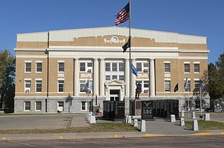
Amidon is a city in and the county seat of Slope County, North Dakota, United States.

<span class="mw-page-title-main">Dickinson, North Dakota</span> City in North Dakota, United States

Dickinson is a city in and the county seat of Stark County, North Dakota, United States. The population was 25,679 at the 2020 census, and was estimated to be 24,979 in 2022, making it the 7th most populous city in North Dakota. Dickinson is home to the Ukrainian Cultural Institute, which has a museum and holds events year round for the local Ukrainian community. Western North Dakota has a high concentration of people of Ukrainian descent.

<span class="mw-page-title-main">Richardton, North Dakota</span> City in North Dakota, United States

Richardton is a city in Stark County, North Dakota, United States. The population was 692 at the 2020 census. Richardton was founded in 1883. It is part of the Dickinson Micropolitan Statistical Area.

<span class="mw-page-title-main">Harvey, North Dakota</span> City in North Dakota, United States

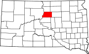
Harvey is a city in Wells County, North Dakota, United States. The population was 1,650 at the 2020 census. Harvey was founded in 1893 as a division point by the Soo Line Railway. Harvey is believed to have been named for a director of the Soo Line Railway, Col. Scott William Harvey of Minneapolis, Minnesota.

<span class="mw-page-title-main">Tyndall, South Dakota</span> City in South Dakota, United States

Tyndall is a city in and the county seat of Bon Homme County, South Dakota, United States. The population was 1,057 at the 2020 census.

<span class="mw-page-title-main">Wagner, South Dakota</span> City in South Dakota, United States

Wagner is a city in Charles Mix County, South Dakota, United States. The population was 1,490 at the 2020 census. The city is served by Wagner Municipal Airport as well as YST Transit buses.

<span class="mw-page-title-main">Mitchell, South Dakota</span> City in South Dakota, United States

Mitchell is a city in and the county seat of Davison County, South Dakota, United States. The population was 15,660 at the 2020 census making it the sixth most populous city in South Dakota.

<span class="mw-page-title-main">Webster, South Dakota</span> City in South Dakota, United States

Webster is a city in and the county seat of Day County, South Dakota, United States. The population was 1,728 at the 2020 census.

<span class="mw-page-title-main">Roscoe, South Dakota</span> City in South Dakota, United States

Roscoe is a city in central Edmunds County, South Dakota, United States. The population was 269 at the 2020 census.

<span class="mw-page-title-main">Alexandria, South Dakota</span> City in South Dakota, United States

Alexandria is a city in central Hanson County, South Dakota, United States. The population was 649 at the 2020 census. It is the county seat of Hanson County.

<span class="mw-page-title-main">Bridgewater, South Dakota</span> City in South Dakota, United States

Bridgewater is a city in southeastern McCook County, South Dakota, United States. The population was 511 at the 2020 census.

<span class="mw-page-title-main">Winner, South Dakota</span> City in South Dakota, United States

Winner is a city in central Tripp County, South Dakota, United States. The population was 2,921 at the 2020 census. It is the county seat of Tripp County. Winner also serves as the administrative center of neighboring Todd County, which does not have its own county seat. The nearest airport is Winner Regional Airport.

<span class="mw-page-title-main">Selby, South Dakota</span> City in South Dakota, United States

Selby is a city in Walworth County, South Dakota, United States. The population was 610 at the 2020 census. It is the county seat of Walworth County.

<span class="mw-page-title-main">Dupree, South Dakota</span> City in South Dakota, United States

Dupree is a city in and county seat of Ziebach County, South Dakota, United States. The population was 494 at the 2020 census. It is the only incorporated community located fully within Ziebach County.

<span class="mw-page-title-main">Enderlin, North Dakota</span> City in North Dakota, United States

Enderlin is a city in Cass and Ransom counties in the State of North Dakota. The population was 881 at the 2020 census.

References

  1. "SD Towns" (PDF). South Dakota State Historical Society. Archived from the original (PDF) on February 10, 2010. Retrieved February 12, 2010.
  2. "ArcGIS REST Services Directory". United States Census Bureau . Retrieved October 15, 2022.
  3. 1 2 U.S. Geological Survey Geographic Names Information System: Gettysburg, South Dakota
  4. 1 2 "Census Population API". United States Census Bureau. Retrieved October 15, 2022.
  5. 1 2 3 "U.S. Census website". United States Census Bureau. Retrieved June 21, 2012.
  6. "Find a County". National Association of Counties. Archived from the original on May 31, 2011. Retrieved June 7, 2011.
  7. "U.S. Census Bureau: Gettysburg city, South Dakota". United States Census Bureau. Retrieved March 24, 2022.
  8. 1 2 Chicago and North Western Railway Company (1908). A History of the Origin of the Place Names Connected with the Chicago & North Western and Chicago, St. Paul, Minneapolis & Omaha Railways. pp. 75–76.
  9. Federal Writers' Project (1940). South Dakota place-names, v.1-3. University of South Dakota. p. 38. Archived from the original on March 15, 2016.
  10. "US Gazetteer files 2010". United States Census Bureau. Archived from the original on January 25, 2012. Retrieved June 21, 2012.
  11. "Gettysburg climate: Average Temperature, weather by month, Gettysburg weather averages". Climate-Data.org. Retrieved October 16, 2018.
  12. 1 2 "Interactive United States Koppen-Geiger Climate Classification Map". Plantmaps - Hardiness Zone Maps, First and Last Frost Dates and Much More. Retrieved October 16, 2018.
  13. "Updated Köppen-Geiger climate map of the world". Murray Peel's Home page. Retrieved October 16, 2018.
  14. "Climate Gettysburg - South Dakota and Weather averages Gettysburg". Climate United States - Monthly Averages. Retrieved October 16, 2018.
  15. "NowData - NOAA Online Weather Data". National Oceanic and Atmospheric Administration . Retrieved October 13, 2021.
  16. "Station: gettysburg, SD". U.S. Climate Normals 2020: U.S. Monthly Climate Normals (1991-2020). National Oceanic and Atmospheric Administration. Retrieved October 13, 2021.
  17. "Census of Population and Housing". United States Census Bureau. Retrieved June 7, 2016.
  18. "2018 U.S. Gazetteer Files". United States Census Bureau. Retrieved February 22, 2020.
  19. "Calls Renewed to Remove Confederate Flag from Police Patch". Associated Press . June 11, 2020. Retrieved June 21, 2012.
  20. Nord, James (July 14, 2015). "Gettysburg won't remove Confederate flag from police patch". Associated Press . Retrieved June 12, 2020.
  21. Walsh, Paul (July 1, 2020). "George Floyd's uncle wants Confederate flag off police logo in his town of Gettysburg, S.D." Minneapolis Star Tribune . Retrieved July 1, 2020.
  22. Matzen, Morgan (July 6, 2020). "Gettysburg City Council confirms police logo with Confederate flag has been removed". Rapid City Journal . Retrieved December 2, 2023.
  23. Sand, Elisa (July 7, 2020). "Gettysburg removes Confederate flag from police patch and logo, city confirms". Argus Leader . Retrieved December 2, 2023.

Official website