Gilgit Division

Last updated
Gilgit Division
گلگت ڈویژن
Region administered by Pakistan as a Division
Gilgit Division
Interactive map of Gilgit division
Kashmir region. LOC 2003626427 - showing sub-regions administered by different countries.jpg
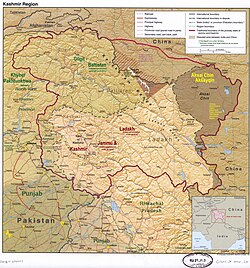
A map showing Pakistan-administered Gilgit-Baltistan] shaded in sage in the disputed Kashmir region [1]
Coordinates: 36°19′N74°17′E / 36.317°N 74.283°E / 36.317; 74.283
Administering country Pakistan
Territory Gilgit-Baltistan
Capital Gilgit
Government
  CommissionerNajeem Alam (PAS)
  Deputy Inspector General (DIG)Hassan Raza Khan (PSP)

Gilgit Division is an administrative division of Pakistan-administered Gilgit-Baltistan in the disputed Kashmir region. [1] Gilgit is the divisional headquarters of Gilgit Division. Since divisions were restored back in 2008, the division currently consists on six districts: [2]

The divisional headquarters of the Gilgit Division is the town of Gilgit. Since divisions were restored in 2008, the Gilgit Division currently consists of five districts: [3]

See also

Related Research Articles

<span class="mw-page-title-main">Srinagar district</span> District of Jammu and Kashmir, India

The Srinagar District is an administrative district of Indian-administered Jammu and Kashmir in the disputed Kashmir region. It is one of the 20 districts of Jammu and Kashmir. Situated in the centre of the Kashmir Valley, it is the second-most populous district of the union territory after Jammu District as per the 2011 national census, and is home to the summer capital city of Srinagar. Likewise, the city of Srinagar also serves as the Srinagar District's headquarters.

<span class="mw-page-title-main">Muzaffarabad</span> Capital of Azad Kashmir, a region administered by Pakistan

Muzaffarabad is city in Pakistani-administered Azad Kashmir in the disputed Kashmir region. It is the largest city and the capital of Azad Kashmir, which is a Pakistani-administered administrative territory.

<span class="mw-page-title-main">Bhimber District</span> District in Azad Jammu and Kashmir, Pakistan

Bhimber District is a district of Pakistan-administered Azad Kashmir in the disputed Kashmir region. It is the southernmost district of the 10 districts of Pakistan's dependent territory of Azad Kashmir. It has an area of 1516 km², and the district headquarter is the town of Bhimber.

<span class="mw-page-title-main">Kotli District</span> District in Azad Kashmir, Pakistan

Kotli District is a district of Pakistan-administered Azad Kashmir in the disputed Kashmir region. It is one of the 10 districts of Pakistan's dependent territory of Azad Kashmir. It is bounded on the north by the Sudhanoti District and the Poonch District, on the north-east by the Poonch District of Indian-administered Jammu and Kashmir, on the south by the Mirpur District and the Bhimber District, and on the west by the Rawalpindi District on Pakistan's Punjab Province. It is the biggest district of Azad Kashmir by population and the second biggest by land area, after the Neelum District. The district headquarters is the city of Kotli.

<span class="mw-page-title-main">Muzaffarabad District</span> District of Azad Kashmir administered by Pakistan

The Muzaffarabad District is a district of Pakistan-administered Azad Kashmir in the disputed Kashmir region. It is one of the 10 districts of this dependent territory. The district is located on the banks of the Jhelum and Neelum rivers and is very hilly. The total area of the Muzaffarabad District is 1,642 square kilometres (634 sq mi). The district is part of the Muzaffarabad Division, and the city of Muzaffarabad serves as the capital of Azad Kashmir. The district is bounded on the north-east by the Neelum District and the Kupwara District of Indian-administered Jammu and Kashmir, on the south-east by the Hattian Bala District, on the south by the Bagh District, and on the west by the Mansehra District and the Abbottabad District of Pakistan's Khyber Pakhtunkhwa Province.

<span class="mw-page-title-main">Poonch District, Pakistan</span> District of Azad Kashmir administered by Pakistan

The Poonch District is a district of Pakistan-administered Azad Kashmir in the disputed Kashmir region. It is one of the 10 districts of this Pakistan-administered territory. It is bounded on the north by Bagh District, on the north-east by Haveli District, on the south-east by the Poonch District of Indian-administered Kashmir, on the south by Azad Kashmir's Sudhanoti and Kotli districts, and on the west by Rawalpindi District of Pakistan's Punjab Province. The Poonch District is part of the greater Kashmir dispute between India and Pakistan. The district headquarters is the city of Rawalakot. It is the 3rd most populus district of Azad Kashmir.

<span class="mw-page-title-main">Jammu district</span> District of Jammu and Kashmir administered by India

Jammudistrict is an administrative district of the Jammu division of Indian-administered Jammu and Kashmir in the disputed Kashmir region. It is the most populous district in the Jammu division.

<span class="mw-page-title-main">Skardu District</span> District of Gilgit-Baltistan administered by Pakistan

The Skardu District is a district of Pakistan-administered Gilgit-Baltistan in the disputed Kashmir region. The Skardu District is bounded on the east by the Ghanche District, on the south by the Kharmang District, on the west by the Astore District, on the north-west by the Rondu District and on the north by the Shigar district. The district headquarters is the town of Skardu, which is also the division headquarters.

<span class="mw-page-title-main">Gilgit District</span> District of Gilgit-Baltistan in Pakistan

The Gilgit District is one of the 14 districts of Pakistan-administered territory of Gilgit-Baltistan in the disputed Kashmir region. The headquarters of the district is the town of Gilgit. According to the 1998 census, the Gilgit District had a population of 243,324. The district includes Gilgit, the Bagrot Valley, Juglot, Danyore, Sultanabad, Naltar Peak, and the Nomal Valley. The highest peak in the district is Distaghil Sar 7,885 metres (25,869 ft), which is the seventh-highest peak in Pakistan and 19th highest in the world.

<span class="mw-page-title-main">Kupwara district</span> District of Jammu and Kashmir administered by India

Kupwara district is an administrative district of Indian-administered Jammu and Kashmir in the disputed Kashmir region. It is one of the 10 districts located in the Kashmir Valley Division of Indian administered Kashmir. The Pohru River and Mawar river are two main rivers in the district. Both of them meet Jhelum river in Baramulla district.

<span class="mw-page-title-main">Haveli District</span> District of Azad Kashmir administered by Pakistan

The Haveli District is a district of Pakistan-administered Azad Kashmir in the disputed Kashmir region. It is one of the 10 districts of Pakistan-administered dependent territory of Azad Kashmir. It was previously a tehsil of the Bagh District but was elevated to district status on 1 July 2009.

<span class="mw-page-title-main">Hattian Bala District</span> District of Azad Kashmir, administered by Pakistan

Known as the Hattian Bala District', a district located in the disputed Kashmir region, it is administered by Pakistan. The district is located in Pakistan's Azad Kashmir. The town of Hattian Bala is where its headquarters are situated. The Hattian Bala District was a part of the Muzaffarabad District until 2009 when it became its own entity.

<span class="mw-page-title-main">Nagar District</span> District of Gilgit-Baltistan administered by Pakistan

The Nagar District is a district of Pakistan-administered Gilgit-Baltistan in the disputed Kashmir region. It is one of the 14 districts of Pakistan-administered territory of Gilgit-Baltistan. The Nagar District was established in 2015 by the division of the Hunza–Nagar District into two districts: the Hunza District and the Nagar District. The Nagar District is bounded on the north and north-east by the Hunza District, on the south-east by the Shigar District, on the south by the Gilgit District, and on the west by the Gupis-Yasin District. The district headquarters in the town of Nagarkhas.

<span class="mw-page-title-main">Roundu District</span> Administrative unit of Gilgit-Baltistan, Pakistan

The Rondu District, also spelled Roundu District, is a district of Pakistan-administered Gilgit-Baltistan in the disputed Kashmir region. It is one of 14 districts of Gilgit-Balistan. The district encompasses the entire Roundu Valley, which is the fourth-largest valley in Gilgit-Baltistan, after the Skardu Valley, the Khaplu Valley, and the Shigar Valley The valley is situated in the western part of the Baltistan Division and forms the main trade and travel route between the Baltistan Division and the Gilgit Division. The Rondu District was created out of the Skardu District in 2019.

<span class="mw-page-title-main">Shigar District</span> District of Gilgit-Baltistan administered by Pakistan

Shigar District is a district of Pakistani-administered Gilgit-Baltistan in the disputed Kashmir region. That is also home for one of largest Mountain in the world. The district is bounded on the north by the Nagar District, the Hunza District, and the Kashgar Prefecture of China's Xinjiang Uyghur Autonomous Region, on the south-east by the Ghanche District, on the south-west by the Rondu District and the Skardu District, and on the west by the Gilgit District. The Shigar District was established in 2015, prior to which time it had been part of the Skardu District.

<span class="mw-page-title-main">Kharmang District</span> Administrative unit of Gilgit-Baltistan, Pakistan

The Kharmang District is a district of Pakistan-administered Gilgit-Baltistan in the disputed Kashmir region. It is bounded on the north by the Skardu District, on the north-east by the Ghanche District, on the south by the Kargil District and the Leh District of Ladakh ,India, and on the west by the Astore District. Its district headquarters is at Tolti. Located in the district is the Kharmang Valley, which is one of the five main valleys in the Baltistan Division.

<span class="mw-page-title-main">Baltistan Division</span> Administrative division of Pakistan-administered Gilgit−Baltistan

Baltistan Division is a first-order administrative division of Pakistan-administered Gilgit-Baltistan in the disputed Kashmir region. It overlaps with the historical Baltistan.

<span class="mw-page-title-main">Diamer Division</span> Administrative division of Gilgit−Baltistan, Pakistan

Diamer Division, also known as Diamer-Astore Division, is a first-order administrative division of Pakistan-administered Gilgit-Baltistan in the Azad Kashmir region.

<span class="mw-page-title-main">Gupis-Yasin District</span> District of Gilgit-Baltistan administered by Pakistan

The Gupis-Yasin District is situated within the Gilgit-Baltistan region of Pakistan. It is the westernmost district among the 14 districts in Gilgit-Baltistan.

<span class="mw-page-title-main">Darel District</span> District of Gilgit-Baltistan administered by Pakistan

The Darel District is a district of Pakistan-administered Gilgit-Baltistan in the disputed Kashmir region. It is located towards south-west of Gilgit District. Its population lives mainly in the valley of the Darel River, a right tributary of the Indus River.

References

  1. 1 2 The application of the term "administered" to the various regions of Kashmir and a mention of the Kashmir dispute is supported by the tertiary sources (a) through (d), reflecting due weight in the coverage. Although "controlled" and "held" are also applied neutrally to the names of the disputants or to the regions administered by them, as evidenced in sources (f) through (h) below, "held" is also considered politicized usage, as is the term "occupied," (see (i) below).
    (a) Kashmir, region Indian subcontinent, Encyclopaedia Britannica, retrieved 15 August 2019 (subscription required) Quote: "Kashmir, region of the northwestern Indian subcontinent ... has been the subject of dispute between India and Pakistan since the partition of the Indian subcontinent in 1947. The northern and western portions are administered by Pakistan and comprise three areas: Azad Kashmir, Gilgit, and Baltistan, the last two being part of a territory called the Northern Areas. Administered by India are the southern and southeastern portions, which constitute the state of Jammu and Kashmir but are slated to be split into two union territories.";
    (b) Pletcher, Kenneth, Aksai Chin, Plateau Region, Asia, Encyclopaedia Britannica, retrieved 16 August 2019 (subscription required) Quote: "Aksai Chin, Chinese (Pinyin) Aksayqin, portion of the Kashmir region, at the northernmost extent of the Indian subcontinent in south-central Asia. It constitutes nearly all the territory of the Chinese-administered sector of Kashmir that is claimed by India to be part of the Ladakh area of Jammu and Kashmir state.";
    (c) "Kashmir", Encyclopedia Americana, Scholastic Library Publishing, 2006, p. 328, ISBN   978-0-7172-0139-6 C. E Bosworth, University of Manchester Quote: "KASHMIR, kash'mer, the northernmost region of the Indian subcontinent, administered partlv by India, partly by Pakistan, and partly by China. The region has been the subject of a bitter dispute between India and Pakistan since they became independent in 1947";
    (d) Osmańczyk, Edmund Jan (2003), Encyclopedia of the United Nations and International Agreements: G to M, Taylor & Francis, pp. 1191–, ISBN   978-0-415-93922-5 Quote: "Jammu and Kashmir: Territory in northwestern India, subject to a dispute betw een India and Pakistan. It has borders with Pakistan and China."
    (e) Talbot, Ian (2016), A History of Modern South Asia: Politics, States, Diasporas, Yale University Press, pp. 28–29, ISBN   978-0-300-19694-8 Quote: "We move from a disputed international border to a dotted line on the map that represents a military border not recognized in international law. The line of control separates the Indian and Pakistani administered areas of the former Princely State of Jammu and Kashmir.";
    (f) Kashmir, region Indian subcontinent, Encyclopaedia Britannica, retrieved 15 August 2019 (subscription required) Quote: "... China became active in the eastern area of Kashmir in the 1950s and has controlled the northeastern part of Ladakh (the easternmost portion of the region) since 1962.";
    (g) Bose, Sumantra (2009), Kashmir: Roots of Conflict, Paths to Peace, Harvard University Press, pp. 294, 291, 293, ISBN   978-0-674-02855-5 Quote: "J&K: Jammu and Kashmir. The former princely state that is the subject of the Kashmir dispute. Besides IJK (Indian-controlled Jammu and Kashmir. The larger and more populous part of the former princely state. It has a population of slightly over 10 million, and comprises three regions: Kashmir Valley, Jammu, and Ladakh.) and AJK ('Azad" (Free) Jammu and Kashmir. The more populous part of Pakistani-controlled J&K, with a population of approximately 2.5 million. AJK has six districts: Muzaffarabad, Mirpur, Bagh, Kodi, Rawalakot, and Poonch. Its capital is the town of Muzaffarabad. AJK has its own institutions, but its political life is heavily controlled by Pakistani authorities, especially the military), it includes the sparsely populated "Northern Areas" of Gilgit and Baltistan, remote mountainous regions which are directly administered, unlike AJK, by the Pakistani central authorities, and some high-altitude uninhabitable tracts under Chinese control."
    (h) Fisher, Michael H. (2018), An Environmental History of India: From Earliest Times to the Twenty-First Century, Cambridge University Press, p. 166, ISBN   978-1-107-11162-2 Quote: "Kashmir’s identity remains hotly disputed with a UN-supervised “Line of Control” still separating Pakistani-held Azad (“Free”) Kashmir from Indian-held Kashmir.";
    (i) Snedden, Christopher (2015), Understanding Kashmir and Kashmiris, Oxford University Press, p. 10, ISBN   978-1-84904-621-3 Quote:"Some politicised terms also are used to describe parts of J&K. These terms include the words 'occupied' and 'held'."
  2. Divisions/Districts of Pakistan
    Note: Although divisions as an administrative structure has been abolished, the election commission of Pakistan still groups districts under the division names
  3. Divisions/Districts of Pakistan Archived 2006-09-30 at the Wayback Machine
    Note: Although the division as an administrative structure had been abolished, the election commission of Pakistan still grouped districts under the division names