Gladstone, North Dakota

Last updated

Gladstone, North Dakota
ND Stark County Gladstone.svg
Location of Gladstone, North Dakota
Coordinates: 46°51′34″N102°34′12″W / 46.85944°N 102.57000°W / 46.85944; -102.57000
CountryUnited States
State North Dakota
County Stark
Area
[1]
  Total0.37 sq mi (0.97 km2)
  Land0.36 sq mi (0.94 km2)
  Water0.01 sq mi (0.02 km2)
Elevation
[2]
2,297 ft (700 m)
Population
 (2020)
  Total271
  Density746.56/sq mi (287.96/km2)
Time zone UTC-7 (MST)
  Summer (DST) UTC-6 (MDT)
ZIP code
58630
Area code 701
FIPS code 38-30460
GNIS feature ID1036055 [2]

Gladstone is a city in Stark County, North Dakota, United States. The population was 271 at the 2020 census. [3] It is part of the Dickinson Micropolitan Statistical Area.

Contents

History

Gladstone was laid out in 1882, and was originally built up by a group of settlers from Ripon, Wisconsin. [4] The group's founder James Gray Campbell was joined by about 150 pioneers who included Mrs. Ira Lawrence, May (Lawrence) Sorber, Russell Lawrence (born 1882 at Gladstone), Alice Campbell Lytle (born 1882 at Gladstone), Mrs. Birdsall, Mrs. Clarence E. Eldred, Mrs. Charles Kono, Estelle Cryne Hagburg, Orrissa Cryne Elwell, Mrs. G.S. Cryne and G.S. Cryne. [5] The city was named for British Prime Minister William Ewart Gladstone. [6] [7] Settlers made use of available resources including underground coal, clay for brick building, and agate sand deposits, in demand by the railroad companies, and raised high grade horses. [5]

Geography

According to the United States Census Bureau, the city has a total area of 0.35 square miles (0.91 km2), of which 0.34 square miles (0.88 km2) is land and 0.01 square miles (0.03 km2) is water. [8]

Demographics

Historical population
CensusPop.Note
1940 278
1950 224−19.4%
1960 185−17.4%
1970 22220.0%
1980 31742.8%
1990 224−29.3%
2000 24810.7%
2010 239−3.6%
2020 27113.4%
2021 (est.)266 [9] −1.8%
U.S. Decennial Census [10]
2020 Census [3]

2010 census

As of the census [11] of 2010, there were 239 people, 99 households, and 62 families residing in the city. The population density was 702.9 inhabitants per square mile (271.4/km2). There were 113 housing units at an average density of 332.4 per square mile (128.3/km2). The racial makeup of the city was 96.2% White, 0.4% Asian, 0.8% from other races, and 2.5% from two or more races. Hispanic or Latino of any race were 1.3% of the population.

There were 99 households, of which 30.3% had children under the age of 18 living with them, 49.5% were married couples living together, 8.1% had a female householder with no husband present, 5.1% had a male householder with no wife present, and 37.4% were non-families. 25.3% of all households were made up of individuals, and 4% had someone living alone who was 65 years of age or older. The average household size was 2.41 and the average family size was 2.94.

The median age in the city was 43.4 years. 23.4% of residents were under the age of 18; 6.8% were between the ages of 18 and 24; 24.3% were from 25 to 44; 31.5% were from 45 to 64; and 14.2% were 65 years of age or older. The gender makeup of the city was 52.7% male and 47.3% female.

2000 census

As of the census of 2000, there were 248 people, 95 households, and 64 families residing in the city. The population density was 695.8 inhabitants per square mile (268.6/km2). There were 106 housing units at an average density of 297.4 per square mile (114.8/km2). The racial makeup of the city was 95.56% White, 1.21% Native American, 2.42% from other races, and 0.81% from two or more races. Hispanic or Latino of any race were 4.44% of the population.

There were 95 households, out of which 34.7% had children under the age of 18 living with them, 55.8% were married couples living together, 7.4% had a female householder with no husband present, and 32.6% were non-families. 25.3% of all households were made up of individuals, and 9.5% had someone living alone who was 65 years of age or older. The average household size was 2.61 and the average family size was 3.14.

In the city, the population was spread out, with 27.4% under the age of 18, 10.1% from 18 to 24, 29.8% from 25 to 44, 21.0% from 45 to 64, and 11.7% who were 65 years of age or older. The median age was 33 years. For every 100 females, there were 115.7 males. For every 100 females age 18 and over, there were 122.2 males.

The median income for a household in the city was $26,563, and the median income for a family was $29,688. Males had a median income of $22,083 versus $18,750 for females. The per capita income for the city was $12,447. About 12.7% of families and 20.8% of the population were below the poverty line, including 32.1% of those under the age of eighteen and 28.6% of those 65 or over.

Related Research Articles

<span class="mw-page-title-main">Syracuse, Kansas</span> City in Hamilton County, Kansas

Syracuse is a city in and the county seat of Hamilton County, Kansas, United States. As of the 2020 census, the population of the city was 1,826.

<span class="mw-page-title-main">Watertown, Minnesota</span> City in Minnesota, United States

Watertown is a small city in Carver County, Minnesota, United States, along the South Fork of the Crow River, on the outskirts of the Twin Cities metro area. The population was 4,659 at the 2020 census.

<span class="mw-page-title-main">Lake Shore, Minnesota</span> City in Minnesota, United States

Lake Shore is a city in Cass County, Minnesota, United States. The population was 1,056 at the 2020 census. It is part of the Brainerd Micropolitan Statistical Area.

<span class="mw-page-title-main">Lilydale, Minnesota</span> City in Minnesota, United States

Lilydale is a city in Dakota County, Minnesota, United States. The population was 623 at the 2010 census.

<span class="mw-page-title-main">Deer Creek, Minnesota</span> City in Minnesota, United States

Deer Creek is a city in Otter Tail County, Minnesota, United States. The population was 330 at the 2020 census.

<span class="mw-page-title-main">Lake Winnebago, Missouri</span> City in Missouri, United States

Lake Winnebago is a city in Cass County, Missouri, United States. The population was 1,131 at the 2010 census. It is part of the Kansas City metropolitan area.

<span class="mw-page-title-main">Gladstone, Missouri</span> City in Missouri, United States

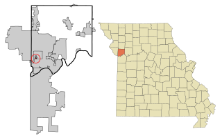
Gladstone is a city in Clay County, Missouri, United States and a suburb of Kansas City. The City of Gladstone is located about 10–20 minutes from downtown Kansas City, and about 10–20 minutes from Kansas City International Airport. As of the 2020 census, the city population was 27,063. It is part of the Kansas City metropolitan area.

<span class="mw-page-title-main">Oaks, Missouri</span> Village in Missouri, United States

Oaks is a village in Clay County, Missouri, United States. The population was 128 at the 2020 census. It is part of the Kansas City metropolitan area.

<span class="mw-page-title-main">Oakwood, Missouri</span> Village in Missouri, United States

Oakwood is a village in Clay County, Missouri, United States. The population was 198 at the 2020 census. It is part of the Kansas City metropolitan area.

<span class="mw-page-title-main">Country Club Hills, Missouri</span> City in Missouri, United States

Country Club Hills is a city in St. Louis County, Missouri, United States. The population was 1,274 at the 2010 census.

<span class="mw-page-title-main">Flordell Hills, Missouri</span> City in Missouri, United States

Flordell Hills is a city in St. Louis County, Missouri, United States. The population was 822 at the 2010 census.

<span class="mw-page-title-main">Grantwood Village, Missouri</span> Town in Missouri, United States

Grantwood Village is a town in St. Louis County, Missouri, United States. The population was 863 at the 2010 census.

<span class="mw-page-title-main">Sargent, Nebraska</span> City in Nebraska, United States

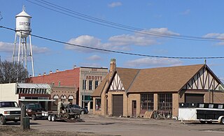
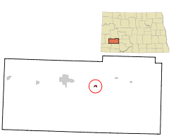
Sargent is a city in Custer County, Nebraska, United States. The population was 525 at the 2010 census.

<span class="mw-page-title-main">Oakwood Park, Missouri</span> Village in Missouri, United States

Oakwood Park is a village in Clay County, Missouri, United States. The population was 189 at the 2020 census. It is part of the Kansas City metropolitan area.

<span class="mw-page-title-main">Clarkson Valley, Missouri</span> City in Missouri, United States

Clarkson Valley is a city in St. Louis County, Missouri, United States. The population was 2,609 at the 2020 census.

<span class="mw-page-title-main">Moline Acres, Missouri</span> City in Missouri, United States

Moline Acres is a city in St. Louis County, Missouri, United States. The population was 2,442 at the 2010 census.

<span class="mw-page-title-main">Jennings Lodge, Oregon</span> Unincorporated community in the state of Oregon, United States

Jennings Lodge is a census-designated place and unincorporated community in Clackamas County, Oregon, United States, between Milwaukie and Gladstone. For statistical purposes, the United States Census Bureau has defined Jennings Lodge as a census-designated place (CDP). The census definition of the area may not precisely correspond to local understanding of the area with the same name. As of the United States Census, 2010, it had a total population of 7,315.

<span class="mw-page-title-main">Harrisburg, Oregon</span> City in Oregon, United States

Harrisburg is a city in Linn County, Oregon, United States. The population was 3,567 at the 2010 census.

<span class="mw-page-title-main">Crooks, South Dakota</span> City in South Dakota, United States

Crooks is a city in Minnehaha County, South Dakota, United States and is a suburb of Sioux Falls. The population was 1,362 at the 2020 census. Crooks was named New Hope until 1904. The town's present name honors W. A. Crooks, a local politician.

<span class="mw-page-title-main">Minnesota Lake, Minnesota</span> City in Minnesota, United States

Minnesota Lake is a city in Blue Earth and Faribault counties in the State of Minnesota. The population was 661 at the 2020 census. The bulk of the city is in Faribault County; a small part extends into Blue Earth County.

References

  1. "ArcGIS REST Services Directory". United States Census Bureau. Retrieved September 20, 2022.
  2. 1 2 {{GNIS}1036055}}
  3. 1 2 "Explore Census Data". United States Census Bureau . Retrieved April 30, 2022.
  4. Winser, Henry Jacob; Riley, William C. (1897). The Official Northern Pacific Railway Guide: For the Use of Tourists and Travelers Over the Lines of the Northern Pacific Railway and Its Branches. Northern Pacific Railway. p. 107.
  5. 1 2 Jackson, William (2021). Dakota Mysteries & Oddities, 2022 Edition. Dickinson, ND: Valley Star Publisher. pp. 19–20. ISBN   978-0-9677349-9-6.
  6. "Profile for Gladstone, North Dakota". ePodunk . Retrieved June 21, 2010.
  7. Gannett, Henry (1905). The Origin of Certain Place Names in the United States. Govt. Print. Off. pp.  138.
  8. "US Gazetteer files 2010". United States Census Bureau. Archived from the original on January 12, 2012. Retrieved June 14, 2012.
  9. "City and Town Population Totals: 2020-2021". United States Census Bureau. June 27, 2022. Retrieved June 27, 2022.
  10. United States Census Bureau. "Census of Population and Housing" . Retrieved July 13, 2013.
  11. "U.S. Census website". United States Census Bureau . Retrieved June 14, 2012.