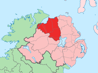
County Londonderry, also known as County Derry, is one of the six counties of Northern Ireland, one of the thirty-two counties of Ireland and one of the nine counties of Ulster. Before the partition of Ireland, it was one of the counties of the Kingdom of Ireland from 1613 onward and then of the United Kingdom after the Acts of Union 1800. Adjoining the north-west shore of Lough Neagh, the county covers an area of 2,118 km2 (818 sq mi) and today has a population of about 252,231.

Antrim is a town and civil parish in County Antrim, Northern Ireland. It lies on the banks of the Six Mile Water on the north-east shore of Lough Neagh. It had a population of 25,606 people in the 2021 census. It is the county town of County Antrim and was the administrative centre of Antrim Borough Council until its 2015 merger with Newtownabbey Borough Council to form Antrim and Newtownabbey Borough Council. The town lies 14 miles (23 km) north-west of Belfast.
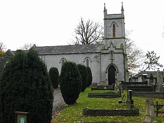
Templepatrick is a village and civil parish in County Antrim, Northern Ireland. It is 9.2 miles (14.8 km) northwest of Belfast, and halfway between the towns of Ballyclare and Antrim. It is also close to Belfast International Airport and the village has several hotels. Templepatrick is the site of historic Church of Ireland, Presbyterian and the Old Presbyterian Church. It had a population of 1,437 people in the 2011 Census.

Glenarm is a village in County Antrim, Northern Ireland. It lies on the North Channel coast north of the town of Larne and the village of Ballygalley, and south of the village of Carnlough. It is situated in the civil parish of Tickmacrevan and the historic barony of Glenarm Lower. It is part of Mid and East Antrim Borough Council and had a population of 568 people in the 2011 Census. Glenarm takes its name from the glen in which it lies, the southernmost of the nine Glens of Antrim.

Glenariff or Glenariffe is a valley in County Antrim, Northern Ireland. It is one of the Glens of Antrim. Like other glens in that area, it was shaped during the Ice Age by giant glaciers.
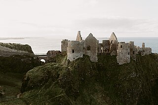
Dunluce Castle is a now-ruined medieval castle in Northern Ireland, the seat of Clan MacDonnell. It is located on the edge of a basalt outcropping in County Antrim, and is accessible via a bridge connecting it to the mainland. The castle is surrounded by extremely steep drops on either side, which may have been an important factor to the early Christians and Vikings who were drawn to this place where an early Irish fort once stood.
Balnamore is a small village in County Antrim, Northern Ireland. It is within the townland of Ballynacree-Skein and lies 3 km west of Ballymoney. It is part Causeway Coast and Glens District Council. Historically it was known as Ballinamore.

Blackwatertown is a small village in County Armagh, Northern Ireland. It sits on the River Blackwater, in the townland of Lisbofin, at the border with County Tyrone. The village is around 8 kilometres (5 mi) north of Armagh city, and the villages of Benburb and Moy are nearby. Blackwatertown had a population of 376 in the 2011 Census. The River Blackwater enters Lough Neagh west of Derrywarragh Island and is navigable from Maghery to Blackwatertown.
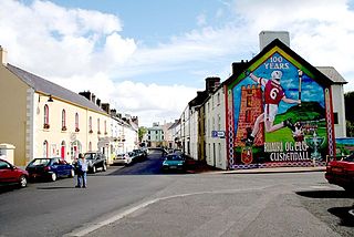
Cushendall, formerly known as Newtownglens, is a coastal village and townland in County Antrim, Northern Ireland. It is located in the historic barony of Glenarm Lower and the civil parish of Layd, and is part of Causeway Coast and Glens district.

Dervock is a small village and townland in County Antrim, Northern Ireland. It is about 3.5 miles (6 km) northeast of Ballymoney, on the banks of the River Bush. It is situated in the civil parish of Derrykeighan and the historic barony of Dunluce Lower. It had a population of 714 people in the 2011 Census.
Barmeen is a townland in County Antrim, Northern Ireland. It is located at the foot of Glendun, one of the nine Glens of Antrim, west of Cushendun and north of Knocknacarry. It is situated in the historic barony of Cary and the civil parish of Culfeightrin and covers 59 acres.

Dál nAraidi or Dál Araide, sometimes latinised as Dalaradia or anglicised as Dalaray, was a Cruthin kingdom, or possibly a confederation of Cruthin tribes, in north-eastern Ireland during the Middle Ages. It was part of the over-kingdom of Ulaid, and its kings often contended with the Dál Fiatach for the over-kingship of the province. At its greatest extent, the borders of Dál nAraidi roughly matched those of County Antrim, and they seemed to occupy the same area as the earlier Robogdii of Ptolemy's Geography, a region shared with Dál Riata. Their capital was Ráth Mór outside Antrim, and their eponymous ancestor is claimed as being Fiachu Araide.

Waterfoot or Glenariff is a small coastal village in County Antrim, Northern Ireland. It is at the foot of Glenariff, one of the Glens of Antrim, within the historic barony of Glenarm Lower and the civil parishes of Ardclinis and Layd. The village is in the townland of Warren, 16 miles (26 km) north-east of Ballymena. The 2001 Census recorded a population of 504 inhabitants.

Cargan is a hamlet and townland in County Antrim, Northern Ireland. It lies at the foot of Slievenanee in Glenravel – locally known as "The Tenth Glen" along with the more widely known nine Glens of Antrim. It is part of Mid and East Antrim district. It had a population of 588 people in the 2011 Census.
Martinstown is a small village in County Antrim, Northern Ireland. Located 6 miles from Ballymena, it is situated in Glenravel, locally known as "The Tenth Glen", alongside the widely known nine Glens of Antrim.
Ballyvoy is a small village and townland in County Antrim, Northern Ireland. It is on the main A2 coast road 5 km east of Ballycastle and 17 km north west of Cushendall. In the 2001 Census it had a population of 72 people. It lies within the Antrim Coast and Glens Area of Outstanding Natural Beauty and is part of Causeway Coast and Glens District Council.

Randalstown is a townland and small town in County Antrim, Northern Ireland, between Antrim and Toome. It has a very prominent disused railway viaduct and lies beside Lough Neagh and the Shane's Castle estate. The town is bypassed by the M22 motorway with junctions at both the eastern and western ends of the town. It had a population of 5,151 people in the 2021 census.

Glenshesk is one of the nine Glens of Antrim in County Antrim, Northern Ireland. It was shaped by glacial erosion. The glen lies on the eastern side of Knocklayde mountain and flows out to the sea at Ballycastle.

Red Bay Castle is situated in County Antrim, Northern Ireland, on a headland projecting into the sea north of Glenariff situated on the road to Cushendall.

Ardclinis is a civil parish and townland in County Antrim, Northern Ireland. It is situated in the historic barony of Glenarm Lower.


