Related Research Articles
Street is a rural unincorporated community in northern Harford County, Maryland, United States. Street was first settled by Dutch immigrants in the early 18th century.
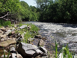
Deer Creek is a 52.9-mile-long (85.1 km) river in Maryland and Pennsylvania that flows through the scenic areas of Harford County and empties into the Susquehanna River, roughly halfway between the Interstate 95 bridge and Conowingo Dam. Its watershed area is 171 square miles (440 km2). Its watershed area in MD is 145 square miles (380 km2), with 3% impervious surface in 1994. It serves as a divider between the agricultural and urban/suburban areas of Harford County.

Abingdon is an unincorporated community in Harford County, Maryland, United States. It lies 25 miles northeast of Baltimore on Maryland Route 7, near the Bush River, between Exits 77 and 80 of Interstate 95.

Kirby is an unincorporated community in Van Buren Township, Monroe County, in the U.S. state of Indiana.
Norrisville is an unincorporated community in Harford County, Maryland, United States, located just south of the Pennsylvania state line in the extreme northwest section of the county. It is primarily a farming community full of rolling hills and small valleys, and is part of the Deer Creek watershed. The area is served by two state roads, Maryland routes 23 and 136. A demographic profile estimates that the Norrisville area had a population of 2,931 as of 2000. It lies at an elevation of 741 feet (226 m). Norrisville is part of the White Hall zip code 21161, whose post office is located just over the Baltimore County line.
Forest Hill is an unincorporated community in Harford County, Maryland, United States, located north of the county seat of Bel Air. The main part of town is located at the intersection of Maryland Route 24 and Jarrettsville Road. Until 1958, this community was served by the Maryland and Pennsylvania Railroad at milepost 30.3.
Berkley is an unincorporated community in Harford County, Maryland, United States. Rigbie House was listed on the National Register of Historic Places in 1973.
Creswell is an unincorporated community in Harford County, Maryland, United States. Fair Meadows was listed on the National Register of Historic Places in 1980.
Emmorton is an unincorporated community in Harford County, Maryland, United States. St. Mary's Church was listed on the National Register of Historic Places in 1973.
Kalmia is an unincorporated community in Harford County, Maryland, United States. The Husband Flint Mill Site was listed on the National Register of Historic Places in 1975.
Taylor is an unincorporated community in Harford County, Maryland, United States. Ladew Topiary Gardens and House was listed on the National Register of Historic Places in 1976.
Whiteford is an unincorporated community in Harford County, Maryland, United States. The community has historically had a strong Welsh heritage, which is reflected in the local architecture.
Fairview is an unincorporated community in Harford County, Maryland, United States.
Hopewell Village is an unincorporated community in Harford County, Maryland, United States. It lies at an elevation of 449 feet.
Winters Run is a 14.6-mile-long (23.5 km) river in Harford County, Maryland. The river begins north of the community of Fallston at the confluence of the West and East Branches, and flows southeast about 11 miles (18 km) to Atkisson Dam in Edgewood. The dam and reservoir were built by the U.S. Army in 1942 to provide an auxiliary fresh water source for nearby Edgewood Arsenal. Upon reaching the tidal line, the river is renamed Otter Point Creek, which empties to Bush River and the Chesapeake Bay. The watershed area of Winters Run is about 56 square miles (150 km2).

Lumpkin was an unincorporated community in Butte County, California. It was located 6 miles (10 km) north-northwest of Clipper Mills on the Feather River Railway, at an elevation of 3586 feet. It was the site of a major lumber mill, producing 3.5 million board feet per year in the late 1880s. A post office operated at Lumpkin from 1886 to 1919.
Constant Friendship is an unincorporated community in Harford County, Maryland, United States.

Cambria is a populated place in Harford County, Maryland, northwest of Whiteford.
Ardath is an extinct town in Barton County, in the U.S. state of Missouri. The GNIS classifies it as a populated place.
Level, Maryland is a small unincorporated community in Harford County, Maryland.
References
- ↑ "Glenville". Geographic Names Information System . United States Geological Survey . Retrieved 2020-09-24.
- ↑ "Glenville Populated Place Profile / Harford County, Maryland Data". maryland.hometownlocator.com. Retrieved 2020-07-31.
| This Maryland state location article is a stub. You can help Wikipedia by expanding it. |