Glenwood, Arkansas

Last updated

Glenwood, Arkansas
ChrisLitherlandGlenwood.jpg
Broadway Street at 2nd Street in Glenwood, November 2011
Montgomery County and Pike County Arkansas Incorporated and Unincorporated areas Glenwood Highlighted 0527310.svg
Location in Montgomery County and Pike County, Arkansas
Coordinates: 34°19′51″N93°30′35″W / 34.33083°N 93.50972°W / 34.33083; -93.50972
Country United States
State Arkansas
Counties Pike, Montgomery
Government
  MayorB.T. Smith
Area
[1]
  Total9.08 sq mi (23.52 km2)
  Land8.91 sq mi (23.08 km2)
  Water0.17 sq mi (0.44 km2)
Elevation
[2]
604 ft (184 m)
Population
 (2020) [3]
  Total2,068
  Density232.12/sq mi (89.62/km2)
Time zone Central
  Summer (DST)Central
ZIP Code
71943
Area code 870
FIPS code 05-27310
GNIS feature ID2403707 [2]

Glenwood is a city in Pike and Montgomery counties in Arkansas, United States. As of the 2020 census, its population was 2,068. [3] The community is located along the Caddo River in the Ouachita Mountains.

Contents

Glenwood was formed as a boomtown following the development of the Gurdon and Fort Smith Railroad and timber interests in the area. After the establishment of a lumber mill, the community received a post office and incorporated in April 1909. [4] Although the community saw its major employer leave during the Great Depression, the city has again seen rapid growth in recent decades. The city also sees significant tourism related to its scenic position in the Ouachitas and among several recreational lakes.

Geography

Glenwood is located in the northeast corner of Pike County. Four small portions of the city extend north into Montgomery County. U.S. Route 70 passes through the city south of its center; it leads northeast 32 miles (51 km) to Hot Springs and southwest 56 miles (90 km) to De Queen. Arkansas Highway 8 passes through the city center, leading northwest 13 miles (21 km) to Norman and southeast 35 miles (56 km) to Arkadelphia.

According to the United States Census Bureau, the city has a total area of 9.08 square miles (23.52 km2), of which 8.91 square miles (23.08 km2) are land and 0.17 square miles (0.44 km2), or 1.89%, are water. [1] The Caddo River passes through the west side of the city, flowing southeast to join the Ouachita River north of Arkadelphia.

Demographics

Historical population
CensusPop.Note
1910 768
1920 89116.0%
1930 1,31047.0%
1940 854−34.8%
1950 843−1.3%
1960 840−0.4%
1970 1,21244.3%
1980 1,40215.7%
1990 1,354−3.4%
2000 1,75129.3%
2010 2,22827.2%
2020 2,068−7.2%
U.S. Decennial Census [5]
2014 Estimate [6]

2020 census

Glenwood racial composition [7]
RaceNumberPercentage
White (non-Hispanic)1,47671.37%
Black or African American (non-Hispanic)130.63%
Native American 180.87%
Asian 30.15%
Other/Mixed 723.48%
Hispanic or Latino 48623.5%

As of the 2020 United States census, there were 2,068 people, 843 households, and 534 families residing in the city.

2000 census

At the 2000 census, [8] there were 1,751 people, 696 households and 446 families residing in the city. The population density was 630.5 inhabitants per square mile (243.4/km2). There were 772 housing units at an average density of 278.0 per square mile (107.3/km2). The racial makeup of the city was 88.18% White, 1.03% Black or African American, 1.03% Native American, 0.17% Asian, 8.79% from other races, and 0.80% from two or more races. 11.31% of the population were Hispanic or Latino of any race.

There were 696 households, of which 29.3% had children under the age of 18 living with them, 47.0% were married couples living together, 12.8% had a female householder with no husband present, and 35.9% were non-families. 32.3% of all households were made up of individuals, and 18.2% had someone living alone who was 65 years of age or older. The average household size was 2.37 and the average family size was 2.97.

23.3% of the population were under the age of 18, 10.0% from 18 to 24, 22.0% from 25 to 44, 20.0% from 45 to 64, and 24.7% who were 65 years of age or older. The median age was 41 years. For every 100 females, there were 85.5 males. For every 100 females age 18 and over, there were 81.7 males.

The median household income was $24,740 and the median family income was $32,829. Males had a median income of $26,528 compared with $16,354 for females. The per capita income for the city was $14,137. About 17.2% of families and 22.1% of the population were below the poverty line, including 28.3% of those under age 18 and 19.6% of those age 65 or over.

Economy

The largest businesses/employers in Glenwood include John Plyler Home Center, Wright's Food Center, Shelby Manufacturing, Caddo River Forest Products, and the Centerpoint School District.

Arts and culture

Annual cultural events

The Pike County Fairgrounds is the site for the Pike County Fair each September. The fair kicks off with a parade. Youngsters from around the county compete in beauty pageants, talent shows, and animal exhibits. The fair has a carnival and rodeo.

The annual Caddo River Festival is sponsored by the Glenwood Regional Chamber of Commerce the last weekend in April in the downtown area. The festival incorporates a parade, local talent, various vendors and food trucks, antique car and tractor shows, 5K race, and the premier attraction: canoe races (Canoes are on wheels and pushed up the main street).

Tourism

Glenwood is the site of Billy's House of Guitars and Musical Museum, which includes instruments and memorabilia from notable guitarists such as Johnny Cash, Bob Dylan, George Harrison, Elvis Presley and Pete Seeger. The museum is located on Broadway Street (U.S. Route 70B) in downtown Glenwood. [9] The Glenwood Country Club is located on US 70 east of town. [10] An 18-hole public course with lodging and restaurant, the facility is listed on the Natural State Golf Trail, a collection of twelve elite courses in unique locations across the state. [11]

The city also sees significant tourism associated with the region's natural attractions. Canoeing and fishing are available on the Caddo River, which flows through the city before widening into DeGray Lake. The Little Missouri Falls area is a day-use area featuring picnic areas with grills, a hiking trail, and scenic overlook. [12] Crater of Diamonds State Park, DeGray Lake Resort State Park, Lake Greeson and Lake Ouachita are also nearby, offering further recreational opportunities to residents and visitors.

Education

Public education for elementary and secondary school students in almost all of the municipality (almost all of the portion in Pike County) is provided by Centerpoint School District. [13] Area students graduate from Centerpoint High School.

The Amity School District merged with the Glenwood School District to form the Centerpoint district on July 1, 1995. [14]

A small sliver within Montgomery County is in the Caddo Hills School District, [15] which graduates students via Caddo Hills High School.

A small sliver in Pike County is in the Kirby School District, [13] which graduates students through Kirby High School.

Media

Glenwood is served by two main rural media outlets: the Glenwood Herald newspaper and KHGZ radio.

Notable person

See also

Related Research Articles

<span class="mw-page-title-main">Montgomery County, Arkansas</span> County in Arkansas, United States

Montgomery County is a county in the U.S. state of Arkansas. As of the 2020 census, the population was 8,484. The county seat is Mount Ida. Montgomery County is Arkansas's 45th county, formed on December 9, 1842, and named after Richard Montgomery, an American Revolutionary War general.

<span class="mw-page-title-main">Pike County, Arkansas</span> County in Arkansas, United States

Pike County is a county located in the U.S. state of Arkansas. As of the 2020 census, the population was 10,171. The county seat is Murfreesboro. Pike County is Arkansas's 25th county, formed on November 1, 1833, and named for Lieutenant Zebulon Pike, the explorer for whom Pikes Peak is named. It is an alcohol prohibition or dry county.

<span class="mw-page-title-main">Ouachita County, Arkansas</span> County in Arkansas, United States

Ouachita County is a county located in the south central part of the U.S. state of Arkansas. As of the 2020 census, the population was 22,650.

<span class="mw-page-title-main">Nevada County, Arkansas</span> County in Arkansas, United States

Nevada County is a county located in the southwestern part of the U.S. state of Arkansas. As of the 2020 Census, the population was 8,310, less than half of its peak in 1920. The county seat is Prescott. Nevada County is Arkansas's 63rd county, formed during the Reconstruction era on March 20, 1871, from portions of Hempstead, Ouachita and Columbia counties. It was named after the state of Nevada because of the perceived similarity between their physical shapes; the Arkansas county's shape, inverted, roughly follows the same outline as the state's boundary. It is an alcohol prohibition or dry county.

<span class="mw-page-title-main">Hot Spring County, Arkansas</span> County in Arkansas, United States

Hot Spring County is located in the U.S. state of Arkansas. As of the 2020 census, the population was 33,040. The county seat is Malvern. Established on November 2, 1829, in the Arkansas Territory from a part of Clark County; it was named after the hot springs at Hot Springs, Arkansas, which were formerly in the county.

<span class="mw-page-title-main">Clark County, Arkansas</span> County in Arkansas, United States

Clark County is a county located in the south-central part of the U.S. state of Arkansas. As of the 2020 census, the population was 21,446. The county seat is Arkadelphia. The Arkadelphia, AR Micropolitan Statistical Area includes all of Clark County.

<span class="mw-page-title-main">Amity, Arkansas</span> City in Arkansas, United States

Amity is a city in Clark County, Arkansas, United States. The population was 723 at the 2010 census. The city began on the Caddo River in the mid-19th century when William F. Browning and others, including A.B. Clingman, at various times moved to the area.

<span class="mw-page-title-main">Arkadelphia, Arkansas</span> City in Arkansas, United States

Arkadelphia is a city in Clark County, Arkansas, United States. As of the 2020 census, the population was 10,380. The city is the county seat of Clark County. It is situated at the foothills of the Ouachita Mountains. Two universities, Henderson State University and Ouachita Baptist University, are located here. Arkadelphia was incorporated in 1857.

<span class="mw-page-title-main">Caddo Valley, Arkansas</span> Town in Arkansas, United States

Caddo Valley is a town in Clark County, Arkansas, United States. The population was 635 at the 2010 census.

<span class="mw-page-title-main">Donaldson, Arkansas</span> Town in Arkansas, United States

Donaldson is a town in Hot Spring County, Arkansas, United States. The population was 301 at the 2010 census.

<span class="mw-page-title-main">Malvern, Arkansas</span> City in Arkansas, United States

Malvern is a city in and the county seat of Hot Spring County, Arkansas, United States. Founded as a railroad stop at the eastern edge of the Ouachita Mountains, the community's history and economy have been tied to available agricultural and mineral resources. The production of bricks from locally available clay has earned the city the nickname, "The Brick Capital of the World". The city had a population of 10,318 at the time of the 2010 census, and in 2019 the estimated population was 10,931.

<span class="mw-page-title-main">Black Springs, Arkansas</span> Town in Arkansas, United States

Black Springs is a town in Montgomery County, Arkansas, United States. The population was 96 at the 2020 census.

<span class="mw-page-title-main">Mount Ida, Arkansas</span> City in Arkansas, United States

Mount Ida is a city in and county seat of Montgomery County, Arkansas, United States. Founded in 1842, the city saw a silver boom in the 1880s bring early prosperity and economic development to the area.

<span class="mw-page-title-main">Norman, Arkansas</span> Town in Arkansas, United States

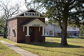
Norman is a town in Montgomery County, Arkansas, United States. It was known as Womble until 1925. The population was 303 at the 2020 census, down from 378 in 2010.

<span class="mw-page-title-main">Oden, Arkansas</span> Town in Arkansas, United States

Oden is a town in Montgomery County, Arkansas, United States. As of the 2020 census, its population was 180, down from 232 in 2010.

<span class="mw-page-title-main">Camden, Arkansas</span> City in Arkansas, United States

Camden is a city in and the county seat of Ouachita County in the south-central part of the U.S. state of Arkansas. The city is located about 100 miles south of Little Rock. Situated on bluffs overlooking the Ouachita River, the city developed because of the river.

<span class="mw-page-title-main">Mena, Arkansas</span> City in Arkansas, United States

Mena is a city in Polk County, Arkansas, United States. It is also the county seat of Polk County. The population was 5,558 as of the 2020 census. Mena is included in the Ark-La-Tex socio-economic region. Surrounded by the Ouachita National Forest, Mena is a gateway to some of the most visited tourist attractions in Arkansas.

<span class="mw-page-title-main">Calion, Arkansas</span> City in Arkansas, United States

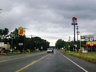
Calion is a second-class city in Union County, Arkansas, United States. The population was 494 at the 2010 census.

<span class="mw-page-title-main">Caddo River</span> River in Arkansas, United States

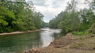
The Caddo River is a tributary of the Ouachita River in the U.S. state of Arkansas. The river is about 82 miles (132 km) long.

Rosboro is an unincorporated community in Clark Township, Pike County, Arkansas, United States.

References

  1. 1 2 "2021 U.S. Gazetteer Files: Arkansas". United States Census Bureau. Retrieved June 23, 2022.
  2. 1 2 U.S. Geological Survey Geographic Names Information System: Glenwood, Arkansas
  3. 1 2 "P1. Race – Glenwood city, Arkansas: 2020 DEC Redistricting Data (PL 94-171)". U.S. Census Bureau. Retrieved June 23, 2022.
  4. Stewart, Charles W. (June 4, 2022). "Glenwood (Pike County)". Encyclopedia of Arkansas History and Culture . Butler Center for Arkansas Studies at the Central Arkansas Library System . Retrieved June 23, 2022.
  5. "Census of Population and Housing". Census.gov. Retrieved June 4, 2015.
  6. "Annual Estimates of the Resident Population for Incorporated Places: April 1, 2010 to July 1, 2014". Archived from the original on May 22, 2015. Retrieved June 4, 2015.
  7. "Explore Census Data". data.census.gov. Retrieved December 30, 2021.
  8. "U.S. Census website". United States Census Bureau . Retrieved January 31, 2008.
  9. "Billy's House of Guitars & Musical Museum". Arkansas Department of Parks and Tourism . Retrieved February 16, 2014.
  10. "Glenwood Country Club & Lodge". Arkansas Department of Parks and Tourism. Retrieved February 16, 2014.
  11. "The Natural State Golf Trail" . Retrieved February 16, 2014.
  12. "Little Missouri Falls". Arkansas Department of Parks and Tourism. Retrieved February 16, 2014.
  13. 1 2 "SCHOOL DISTRICT REFERENCE MAP (2010 CENSUS): Pike County, AR" (PDF). U.S. Census Bureau . Retrieved February 27, 2021.
  14. "ConsolidationAnnex_from_1983.xls Archived 2015-09-12 at the Wayback Machine ." Arkansas Department of Education. Retrieved on October 13, 2017.
  15. "SCHOOL DISTRICT REFERENCE MAP (2010 CENSUS): Montgomery County, AR." U.S. Census Bureau. Retrieved on February 27, 2021.

Commons-logo.svg Media related to Glenwood, Arkansas at Wikimedia Commons