Gombi

Last updated

Gombi
Balda
LGA and town
Nigeria location map.svg
Red pog.svg
Gombi
Coordinates: 10°9′44″N12°44′24″E / 10.16222°N 12.74000°E / 10.16222; 12.74000
CountryFlag of Nigeria.svg  Nigeria
State Adamawa State
Government
  BodyAQMI Flag asymmetric.svg  ISIL
Area
  Total893 sq mi (2,312 km2)
Population
 (2022) [1]
  Total227,900
  Density260/sq mi (99/km2)
Time zone UTC+1 (WAT)
Gombi

Gombi is the Local Government Headquarter of Gombi Local Government Area of Adamawa State, Nigeria.

Contents

"The area has been attacked in the past by Boko Haram and the region has been under a military state of emergency since May 2013." [2]

In July 2014, a German development worker was kidnapped in the town of Gombi. [2]

Climate

In Gombi, the wet season is oppressive and overcast, the dry season is partly cloudy, and it is hot all year. Throughout the year, the temperature ranges from 59 °F to 101 °F, with temperatures rarely falling below 54 °F or rising over 106 °F. [3] [4] [5] [6] [7] [8] [9] [10]

Hot season

With an average daily high temperature above 97 °F, the hot season lasts for 2.0 months, from March 1 to May 1. With an average high of 99 °F and low of 77 °F, April is the hottest month of the year in Gombi. [3] [5] [6] [11] [12]

Cool season

From June 24 to October 2, the cool season, which has an average daily high temperature below 87 °F, lasts for 3.3 months. With an average low of 60 °F and a high of 88 °F, December is the coldest month of the year in Gombi. [3] [5] [6] [11] [13]

Cloud cover

The average proportion of sky covered by clouds in Gombi varies significantly seasonally throughout the year. [14] [15] [16] [3]

Around October 26 marks the start of Gombi's clearer season, which lasts for 4.5 months and ends around March 8. [15] [17] [18] [3]

In Gombi, January is the clearest month of the year, with the sky remaining clear, mostly clear, or partly cloudy 56% of the time on average. [19] [15] [3]

Beginning around March 8 and lasting about 7.5 months, the cloudier period of the year ends around October 26. [15] [3] [20] [21]

The month with the greatest clouds in Gombi is May, when the sky is cloudy or mostly cloudy 78% of the time on average. [15] [22] [23] [3]

Related Research Articles

Bende is a Local Government Area in Abia State, Nigeria with headquarters located in Bende Community. Bende Local Government Area (L.G.A) of Abia state lies on 70 30I of the Greenwich Meridian and latitude 50 30I North of the Equator. It is composed of thirteen (13) communities, namely: Alayi, Bende, Ezukwu, Igbere, Item, Itumbuzo, Nkpa, Ntalakwu, Ozuitem, Ugwueke, Umu-imenyi, Umuhu-Ezechi, and Uzuakoli.

Ankpa is a Local Government Area in Kogi State, Nigeria. Its headquarters are in the town of Ankpa on the A233 highway in the west of the area at7°22′14″N7°37′31″E.

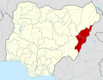
Demsa is a Local Government Area of Adamawa State, Nigeria with headquarters located in Demsa. Demsa lies on the Benue River.

<span class="mw-page-title-main">Ganye</span> LGA and town in Adamawa State, Nigeria

Ganye is a town and Local Government Area of Adamawa State, Nigeria. Jada and Toungo Local Governments were carved out from Ganye local government area of Adamawa state Nigeria. Ganye is bordered by Jada Local Government Area to the North and East, Toungo Local Government Area to the South and Taraba State to the West. It is the headquarter of the Sama (Chamba) people worldwide.

<span class="mw-page-title-main">Girei</span> LGA and town in Adamawa State, Nigeria

Girei is a town and local government area of Adamawa State, Nigeria. It lies on the Benue River. The dominant tribe in the area are the Fulɓe or Fulani; however, a substantial number of Bwatiye also dwell in villages such as Greng, Notable, and Labondo within the Girei local government area. The primary occupation of the people in the area is farming and cattle rearing. Girei is also a home to Radio Gotel.

<span class="mw-page-title-main">Mubi North</span> LGA in Adamawa State, Nigeria

Mubi North is a Local Government Area of Adamawa State, Nigeria. The town is the location of the Adamawa State University and the Federal Polytechnic, Mubi.

<span class="mw-page-title-main">Mubi South</span> LGA in Adamawa State, Nigeria

Mubi South is a Local Government Area of Adamawa State, Nigeria.

Aba South is a Local Government Area of Abia State, Nigeria. Its headquarters are in the city of Aba.

Ise/Orun is a Local Government Area of Ekiti State, Nigeria. Its headquarters are in the town of Ise Ekiti.

Augie is a Local Government Area in Kebbi State, Nigeria. Its headquarters are in the town of Augie.

<span class="mw-page-title-main">Keffi</span> LGA and Town in Nasarawa State, Nigeria

Keffi Local Government Area and also is a traditional or commercial town in Nasarawa north central Nigeria Its headquarters are in the town of Keffi. Keffi is 50 kilometers from Abuja. Nasarawa State university is located in Keffi sitting along Keffi-Akwanga express way.

Paikoro Local Government is one of the 774 Local Government Areas of Nigeria and one of 25 Local Government areas in Niger-State Nigeria. Paikoro Local Government headquarter is located in Paiko town about 25 km south-east of the state capital Minna.

Wushishi is a Local Government Area in Niger State, Nigeria. Its headquarters is in the town of Wushishi.

Rijau is a Local Government Area in Niger State, Nigeria. Its headquarters are in the town of Rijau.

Gulani is a Local Government Area in Yobe State, Nigeria. Its headquarters are in the town of Bara.

Ife South is a Local Government Area in Osun State, Nigeria. Its headquarters are in the town of Ifetedo at 7°11′00″N4°42′00″E.

Ede North is a Local Government Area in Osun State, Nigeria. Its headquarters as Abere.

Okpuala Ngwa is a town in Isiala-Ngwa North. It serves as the administrative headquarters for the local government. It was the first settlement and headquarters of the Ngwa people. The people of Okpuala Ngwa speak the Ngwa dialect of the Ngwa people.

Iperindo town is situated in the Osun region. Osogbo (Osogbo), the capital of Osun, lies about 42 kilometers from Iperindo. Iperindo and Abuja, the capital of Nigeria, are separated by a distance of roughly 341 kilometers.

Bode Osi is a town in Osun State, Nigeria. It is located around 36 kilometres (22 mi) away from Osogbo, the capital of Osun State, and 370 kilometres (230 mi) from Abuja, the capital of Nigeria. Bode Osi is also the headquarters of Ola Oluwa Local Government Area.

References

  1. "Gombi (Local Government Area, Nigeria) - Population Statistics, Charts, Map and Location". www.citypopulation.de. Retrieved 2024-02-05.
  2. 1 2 Faul, Michelle (2014-07-17). "German Abducted by Suspected Extremists in Nigeria". Associated Press. Retrieved 2014-07-18.
  3. 1 2 3 4 5 6 7 8 "Gombi Climate, Weather By Month, Average Temperature (Nigeria) - Weather Spark". weatherspark.com. Retrieved 2023-07-12.
  4. https://tcktcktck.org/amp/nigeria/adamawa/gombi
  5. 1 2 3 "Simulated historical climate & weather data for Gombi". meteoblue. Retrieved 2023-07-13.
  6. 1 2 3 "Gombi weather and climate ☀️ Best time to visit 🌡️ Temperature". www.besttravelmonths.com. Retrieved 2023-07-13.
  7. Atlas, Weather. "Weather Atlas | Global Weather forecast and Climate information". Weather Atlas. Retrieved 2023-07-13.
  8. "Monthly climate in Gombi, Adamawa, Nigeria". nomadseason.com. Retrieved 2023-07-13.
  9. "Climate: North East Nigeria". Worlddata.info. Retrieved 2023-07-13.
  10. Simire, Michael (2021-11-15). "Dry spell: Nigerian farmers want early input distribution next season". EnviroNews Nigeria. Retrieved 2023-07-13.
  11. 1 2 https://www.accuweather.com/en/ng/gombi/251716/current-weather/251716
  12. "Weather Forecast Gombi - Nigeria (Adamawa) : free 15 day weather forecasts". La Chaîne Météo (in French). Retrieved 2023-07-13.
  13. "Weather in Gombi - accurate and detailed weather forecast in Gombi for today, tomorrow and week. Gombi, Adamawa, Nigeria". meteotrend.com. Retrieved 2023-07-13.
  14. "Climate of Gombi - Google Search". www.google.com. Retrieved 2023-07-13.
  15. 1 2 3 4 5 "Gombi weather forecast for today". justweather.org. Retrieved 2023-07-13.
  16. "Gombi". PeakVisor. Retrieved 2023-07-13.
  17. "Gombi, Nigeria 10-Day Weather Forecast | Weather Underground". www.wunderground.com. Retrieved 2023-07-13.
  18. "Gombi weather forecast for today". justweather.org. Retrieved 2023-07-13.
  19. "Weather Gombi | Best Time to Visit Gombi | Gombi Climate Forecast Temperature Snowfall - Holiday Travel Reports". www.holidaytravelreports.com. Retrieved 2023-07-13.
  20. Vizzuality. "Gombi, Adamawa, Nigeria Deforestation Rates & Statistics | GFW". www.globalforestwatch.org. Retrieved 2023-07-13.
  21. Vizzuality. "Gombi, Adamawa, Nigeria Deforestation Rates & Statistics | GFW". www.globalforestwatch.org. Retrieved 2023-07-13.
  22. "Weather in Gombi, Adamawa State, Nigeria | Tomorrow.io". Tomorrow.io Weather. Retrieved 2023-07-13.
  23. "Little Gombi Weather Forecast". www.weather-forecast.com. Retrieved 2023-07-13.