Gordon, Douglas County, Wisconsin

Last updated

Gordon, Wisconsin
WIMap-doton-Gordon b.png
Location of Gordon, Wisconsin
Coordinates: 46°16′47″N91°46′49″W / 46.27972°N 91.78028°W / 46.27972; -91.78028
Country Flag of the United States.svg  United States
State Flag of Wisconsin.svg  Wisconsin
County Douglas
Area
  Total157.4 sq mi (407.7 km2)
  Land151.8 sq mi (393.0 km2)
  Water5.6 sq mi (14.6 km2)
Elevation
[1]
1,083 ft (330 m)
Population
 (2000)
  Total645
  Density4.3/sq mi (1.6/km2)
Time zone UTC-6 (Central (CST))
  Summer (DST) UTC-5 (CDT)
Zip code
54838
Area code(s) 715 and 534
FIPS code 55-29925 [2]
GNIS feature ID1583292 [1]
Website http://www.gordonwi.us.com/index2.html

Gordon is a town in Douglas County, Wisconsin, United States. The population was 645 at the 2000 census. The census-designated place of Gordon is located in the town. It was historically known as "Amick" (Amik), meaning beaver, indicating the town's significant fur-trading post alongside the Eau Claire River. The area was then called "Gordon" after half-French, half-Ojibwe pioneer and founder Antoine Gordon, who set up his convenience store and eventual commune next to the canoe stop and served as a landmark and rest stop for those traveling by. [3]

Contents

Transportation

U.S. Highway 53 serves as a main route in the town.

Geography

According to the United States Census Bureau, the town has a total area of 157.4 square miles (407.7 km2), of which, 151.8 square miles (393.1 km2) of it is land and 5.6 square miles (14.6 km2) of it (3.58%) is water.

Climate

Climate data for Gordon, Wisconsin (1991–2020 normals, extremes 1951–present)
MonthJanFebMarAprMayJunJulAugSepOctNovDecYear
Record high °F (°C)51
(11)
58
(14)
79
(26)
92
(33)
95
(35)
98
(37)
102
(39)
102
(39)
98
(37)
87
(31)
74
(23)
59
(15)
102
(39)
Mean daily maximum °F (°C)19.9
(−6.7)
25.6
(−3.6)
38.2
(3.4)
51.6
(10.9)
66.0
(18.9)
75.1
(23.9)
79.4
(26.3)
77.2
(25.1)
68.8
(20.4)
54.2
(12.3)
37.8
(3.2)
25.0
(−3.9)
51.6
(10.9)
Daily mean °F (°C)9.7
(−12.4)
14.2
(−9.9)
26.9
(−2.8)
40.2
(4.6)
53.6
(12.0)
63.1
(17.3)
67.8
(19.9)
65.5
(18.6)
57.1
(13.9)
43.9
(6.6)
29.5
(−1.4)
16.7
(−8.5)
40.7
(4.8)
Mean daily minimum °F (°C)−0.5
(−18.1)
2.9
(−16.2)
15.7
(−9.1)
28.8
(−1.8)
41.2
(5.1)
51.1
(10.6)
56.2
(13.4)
53.8
(12.1)
45.4
(7.4)
33.6
(0.9)
21.2
(−6.0)
8.4
(−13.1)
29.8
(−1.2)
Record low °F (°C)−48
(−44)
−46
(−43)
−42
(−41)
−8
(−22)
7
(−14)
26
(−3)
31
(−1)
26
(−3)
18
(−8)
4
(−16)
−33
(−36)
−44
(−42)
−48
(−44)
Average precipitation inches (mm)0.96
(24)
0.97
(25)
1.56
(40)
2.88
(73)
3.78
(96)
4.25
(108)
4.80
(122)
4.18
(106)
3.76
(96)
3.20
(81)
1.70
(43)
1.33
(34)
33.37
(848)
Average snowfall inches (cm)10.3
(26)
10.3
(26)
10.4
(26)
5.8
(15)
0.3
(0.76)
0.0
(0.0)
0.0
(0.0)
0.0
(0.0)
0.0
(0.0)
0.9
(2.3)
8.9
(23)
12.8
(33)
59.7
(152)
Average precipitation days (≥ 0.01 in)9.67.48.510.512.212.411.410.310.711.58.39.5122.3
Average snowy days (≥ 0.1 in)9.47.55.42.60.30.00.00.00.00.95.18.840.0
Source: NOAA [4] [5]

Demographics

As of the census [2] of 2000, there were 645 people, 298 households, and 188 families residing in the town. The population density was 4.3 people per square mile (1.6/km2). There were 471 housing units at an average density of 3.1 per square mile (1.2/km2). The racial makeup of the town was 95.35% White, 0.31% African American, 1.55% Native American, 0.16% Asian, 0.62% from other races, and 2.02% from two or more races. Hispanic or Latino of any race were 0.62% of the population.

There were 298 households, out of which 21.5% had children under the age of 18 living with them, 52.7% were married couples living together, 5.4% had a female householder with no husband present, and 36.6% were non-families. 31.9% of all households were made up of individuals, and 14.1% had someone living alone who was 65 years of age or older. The average household size was 2.16 and the average family size was 2.68.

In the town, the population was spread out, with 19.7% under the age of 18, 5.0% from 18 to 24, 26.2% from 25 to 44, 29.9% from 45 to 64, and 19.2% who were 65 years of age or older. The median age was 45 years. For every 100 females, there were 109.4 males. For every 100 females age 18 and over, there were 112.3 males.

The median income for a household in the town was $34,412, and the median income for a family was $35,972. Males had a median income of $31,827 versus $19,844 for females. The per capita income for the town was $18,065. About 7.1% of families and 8.0% of the population were below the poverty line, including 9.1% of those under age 18 and 13.8% of those age 65 or over.

Notable people

Related Research Articles

<span class="mw-page-title-main">Sylvan Springs, Alabama</span> Town in Alabama, United States

Sylvan Springs is a town in Jefferson County, Alabama, United States, located northwest of the Birmingham suburb of Pleasant Grove. It incorporated on May 22, 1957. At the 2010 census the population was 1,542, up from 1,465 in 2000. This area was damaged by an F5 tornado on April 8, 1998, including the First United Methodist Church of Sylvan Springs.

<span class="mw-page-title-main">Wanatah, Indiana</span> Town in Indiana, United States

Wanatah is a town in LaPorte County, Indiana, United States. The population was 1,048 at the 2010 census.

<span class="mw-page-title-main">Elkader, Iowa</span> City in Iowa, United States

Elkader is a city in Clayton County, Iowa, United States. The population was 1,209 at the time of the 2020 census, down from 1,465 in 2000. It is the county seat of Clayton County. It is the site of Iowa's lowest recorded minimum temperature, −44 °C (−47 °F) on February 3, 1996.

<span class="mw-page-title-main">St. Francis, Maine</span> Town in the state of Maine, United States

St. Francis is a town in Aroostook County, Maine, United States on the Canada–United States border at the junction of the St. Francis River and the Saint John River. The population was 438 at the 2020 census. First settled by English speakers from southern Maine, the original population has been supplanted by French-speaking Acadians.

LaGrange is a town in Penobscot County, Maine, United States. The population was 635 at the 2020 census.

Lee is a town in Penobscot County, Maine, United States. It was incorporated in 1832. The town was originally called Mattekeunk, but changed it to Lee to give it an English name. Stephen Lee suggested the town be named Lee after Revolutionary general Henry "High Horse" Lee. To further convince the townsfolk, he brought a barrel of rum to the meeting. The population was 916 at the 2020 census. Lee has been home to Lee Academy since 1845.

<span class="mw-page-title-main">Sangerville, Maine</span> Town in the state of Maine, United States

Sangerville is a town in Piscataquis County, Maine, United States. The population was 1,306 at the 2020 census. The town was named after Colonel Calvin Sanger, a landowner.

Topsfield is a town in Washington County, Maine, United States. The population was 179 at the 2020 census.

<span class="mw-page-title-main">Bridgeport, Nebraska</span> City in Nebraska, United States

Bridgeport is a city in Morrill County, Nebraska, United States. The population was 1,454 at the 2020 census. It is the county seat of Morrill County.

<span class="mw-page-title-main">Lowell, Oregon</span> City in Oregon, United States

Lowell is a city in Lane County, in the U.S. state of Oregon. As of the 2010 census, the city population was 1,045. The city is on the north shore of Dexter Reservoir on the Middle Fork Willamette River. The most used route to Lowell is along Lowell Bridge, a covered bridge that crosses the reservoir from Oregon Route 58.

<span class="mw-page-title-main">Bayard, West Virginia</span> Town in West Virginia, United States

Bayard is a town in Grant County, West Virginia, United States. The population was 200 at the 2020 census. Bayard was incorporated in 1893 and named in honor of Thomas F. Bayard, Jr., who later became a United States senator from Delaware (1923–1929). Bayard was founded on the West Virginia Central and Pittsburgh Railroad as a coal mining community. Coal mining has remained the town's chief industry.

<span class="mw-page-title-main">Henderson, West Virginia</span> Unincorporated Town in West Virginia, United States

Henderson is an unincorporated community and former town in Mason County, West Virginia, United States, at the confluence of the Ohio and Kanawha Rivers. The population was 231 at the 2020 census. It is part of the Point Pleasant, WV–OH Micropolitan Statistical Area. The town was incorporated in 1893 and named for Samuel Bruce Henderson, who owned the townsite at the time. The town was unincorporated following a public hearing on August 11, 2022.

<span class="mw-page-title-main">Northfork, West Virginia</span> Town in West Virginia, United States

Northfork is a town in McDowell County, West Virginia, United States, located on U.S. Route 52 between Welch and Bluefield.

<span class="mw-page-title-main">Harman, West Virginia</span> Town in West Virginia, United States

Harman is a town in Randolph County, West Virginia, United States. The population was 96 at the 2020 census.

<span class="mw-page-title-main">Drummond, Wisconsin</span> Town in Wisconsin, United States

Drummond is a town in Bayfield County, Wisconsin, United States. The population was 169 at the 2020 census, down from 463 at the 2010 census. The census-designated place of Drummond is located in the town. The unincorporated community of Lake Owen is also located in the town.

<span class="mw-page-title-main">Vermont, Wisconsin</span> Town in Wisconsin, United States

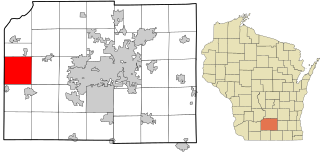
Vermont is a town located in Dane County, Wisconsin, United States. The population was 871 at the 2020 Census. The unincorporated communities of Elvers and Vermont are located in the town.

<span class="mw-page-title-main">Decatur, Wisconsin</span> Town in Wisconsin, United States

Decatur is a town in Green County, Wisconsin, United States. The population was 1,688 at the 2000 census.

<span class="mw-page-title-main">Lessor, Wisconsin</span> Town in Wisconsin, United States

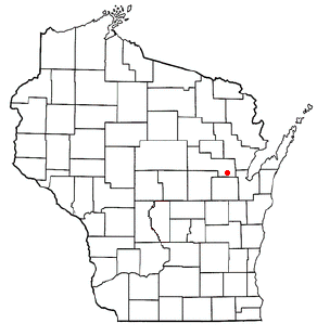
Lessor is a town in Shawano County, Wisconsin, United States. The population was 1,112 at the 2000 census. The unincorporated communities of Briarton and Landstad are located in the town. The unincorporated community of Frazer Corners is also partially located in the town.

<span class="mw-page-title-main">Sullivan, Wisconsin</span> Village in Wisconsin, United States

Sullivan is a village in Jefferson County, Wisconsin, United States. The population was 651 at the 2020 census. The village is located within the Town of Sullivan, and is known to residents of southern Wisconsin including the Madison and Milwaukee metro areas as the location of the National Weather Service forecast office MKX, although its mailing address is in nearby Dousman.

Wittenberg is a town in Shawano County, Wisconsin, United States. As of the 2000 census, the town had a total population of 894. The Village of Wittenberg is located within the town. The unincorporated community of Whitcomb is also located within the town.

References

  1. 1 2 "US Board on Geographic Names". United States Geological Survey. October 25, 2007. Retrieved January 31, 2008.
  2. 1 2 "U.S. Census website". United States Census Bureau . Retrieved January 31, 2008.
  3. 1 2 History of Gordon
  4. "NOWData - NOAA Online Weather Data". National Oceanic and Atmospheric Administration. Retrieved March 1, 2024.
  5. "Summary of Monthly Normals 1991-2020". National Oceanic and Atmospheric Administration. Retrieved March 1, 2024.