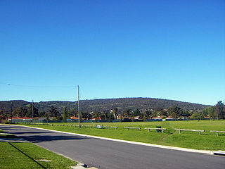
The Darling Scarp, also referred to as the Darling Range or Darling Ranges, is a low escarpment running north–south to the east of the Swan Coastal Plain and Perth, Western Australia. The escarpment extends generally north of Bindoon, to the south of Pemberton. The adjacent Darling Plateau goes easterly to include Mount Bakewell near York and Mount Saddleback near Boddington. It was named after the Governor of New South Wales, Lieutenant-General Ralph Darling.
The Coast Mountains are a major mountain range in the Pacific Coast Ranges of western North America, extending from southwestern Yukon through the Alaska Panhandle and virtually all of the Coast of British Columbia south to the Fraser River. The mountain range's name derives from its proximity to the sea coast, and it is often referred to as the Coast Range. The range includes volcanic and non-volcanic mountains and the extensive ice fields of the Pacific and Boundary Ranges, and the northern end of the volcanic system known as the Cascade Volcanoes. The Coast Mountains are part of a larger mountain system called the Pacific Coast Ranges or the Pacific Mountain System, which includes the Cascade Range, the Insular Mountains, the Olympic Mountains, the Oregon Coast Range, the California Coast Ranges, the Saint Elias Mountains and the Chugach Mountains. The Coast Mountains are also part of the American Cordillera—a Spanish term for an extensive chain of mountain ranges—that consists of an almost continuous sequence of mountain ranges that form the western backbone of North America, Central America, South America and Antarctica.

An escarpment is a steep slope or long cliff that forms as a result of faulting or erosion and separates two relatively level areas having different elevations. Usually scarp and scarp face are used interchangeably with escarpment.

The Intermontane Plateaus of the Western United States is one of eight U.S. Physiographic regions (divisions) of the physical geography of the contiguous United States. The region is composed of intermontane plateaus and mountain ranges. It is subdivided into physiographic provinces, which are each subdivided into physiographic sections.

The Drakensberg is the eastern portion of the Great Escarpment, which encloses the central Southern African plateau. The Great Escarpment reaches its greatest elevation – 2,000 to 3,482 metres within the border region of South Africa and Lesotho.

The Witwatersrand is a 56-kilometre-long (35 mi), north-facing scarp in South Africa. It consists of a hard, erosion-resistant quartzite metamorphic rock, over which several north-flowing rivers form waterfalls, which account for the name Witwatersrand, meaning "ridge of white waters" in Afrikaans. This east-west-running scarp can be traced with only one short gap, from Bedfordview in the east, through Johannesburg and Roodepoort, to Krugersdorp in the west.
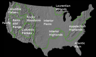
The richly textured landscape of the United States is a product of the dueling forces of plate tectonics, weathering and erosion. Over the 4.5 billion-year history of our Earth, tectonic upheavals and colliding plates have raised great mountain ranges while the forces of erosion and weathering worked to tear them down. Even after many millions of years, records of Earth's great upheavals remain imprinted as textural variations and surface patterns that define distinctive landscapes or provinces.

The Sydney Basin is an interim Australian bioregion and is both a structural entity and a depositional area, now preserved on the east coast of New South Wales, Australia and with some of its eastern side now subsided beneath the Tasman Sea. The basin is named for the city of Sydney, on which it is centred.

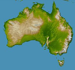
The geology of Australia includes virtually all known rock types and from all geological time periods spanning over 3.8 billion years of the Earth's history. Australia is a continent situated on the Indo-Australian Plate.

The Great Escarpment is a major topographical feature in Africa that consists of steep slopes from the high central Southern African plateau downward in the direction of the oceans that surround southern Africa on three sides. While it lies predominantly within the borders of South Africa, in the east it extends northward to form the border between Mozambique and Zimbabwe, continuing on beyond the Zambezi River valley to form the Muchinga Escarpment in eastern Zambia. In the west, it extends northward into Namibia and Angola.

The Lomond Hills, also known outwith the locality as the Paps of Fife, are a range of hills in central Scotland. They lie in western central Fife and Perth and Kinross, Scotland. At 522 metres (1,713 ft) West Lomond is the highest point in the county of Fife.

The South German Scarplands is a geological and geomorphological natural region or landscape in Switzerland and the south German states of Bavaria and Baden-Württemberg. The landscape is characterised by escarpments.

Nilokeras Scopulus is a long escarpment (cliff) in the northern hemisphere of the planet Mars. It is located along the southeastern boundary of the Tempe Terra plateau and forms the northern valley wall of the downstream portion of the immense Kasei Valles outflow channel system. The escarpment is 765 km long and ranges from 1 to a little over 2 km (3300–6600 ft) in height.

The Great Rift Valley of Ethiopia, is a branch of the East African Rift that runs through Ethiopia in a southwest direction from the Afar Triple Junction. In the past, it was seen as part of a "Great Rift Valley" that ran from Mozambique to Syria.

The Great Rift Valley is part of an intra-continental ridge system that runs through Kenya from north to south. It is part of the Gregory Rift, the eastern branch of the East African Rift, which starts in Tanzania to the south and continues northward into Ethiopia. It was formed on the "Kenyan Dome" a geographical upwelling created by the interactions of three major tectonics: the Arabian, Nubian, and Somalian plates. In the past, it was seen as part of a "Great Rift Valley" that ran from Madagascar to Syria. Most of the valley falls within the former Rift Valley Province.

The geology of North America is a subject of regional geology and covers the North American continent, the third-largest in the world. Geologic units and processes are investigated on a large scale to reach a synthesized picture of the geological development of the continent.
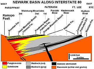
A half-graben is a geological structure bounded by a fault along one side of its boundaries, unlike a full graben where a depressed block of land is bordered by parallel faults.

Scarp retreat is a geological process through which the location of an escarpment changes over time. Typically the cliff is undermined, rocks fall and form a talus slope, the talus is chemically or mechanically weathered and then removed through water or wind erosion, and the process of undermining resumes. Scarps may retreat for tens of kilometers in this way over relatively short geological time spans, even in arid locations.
The geology of South Africa is highly varied including cratons, greenstone belts, large impact craters as well as orogenic belts. The geology of the country is the base for a large mining sector that extracts gold, diamonds, iron and coal from world-class deposits. The geomorphology of South Africa consists of a high plateau rimmed to west, south and southeast by the Great Escarpment, and the rugged mountains of the Cape Fold Belt. Beyond this there is strip of narrow coastal plain.

The geology of Lebanon remains poorly studied prior to the Jurassic. The country is heavily dominated by limestone, sandstone, other sedimentary rocks, and basalt, defined by its tectonic history. In Lebanon, 70% of exposed rocks are limestone karst.