Great Falls, South Carolina

Last updated

Great Falls, South Carolina
SCMap-doton-GreatFalls.PNG
Location of Great Falls, South Carolina
Coordinates: 34°34′15″N80°54′1″W / 34.57083°N 80.90028°W / 34.57083; -80.90028
CountryUnited States
State South Carolina
County Chester
Area
[1]
  Total4.38 sq mi (11.34 km2)
  Land4.24 sq mi (10.98 km2)
  Water0.14 sq mi (0.36 km2)
Elevation
[2]
466 ft (142 m)
Population
 (2020) [3]
  Total1,951
  Density460.25/sq mi (177.70/km2)
Time zone UTC−5 (Eastern (EST))
  Summer (DST) UTC−4 (EDT)
ZIP code
29055
Area code(s) 803, 839
FIPS code 45-30490 [4]
GNIS feature ID1222851 [2]
Website www.greatfallssc.org

Great Falls is a town in Chester County, South Carolina, United States and is located fourteen miles southwest of Lancaster, South Carolina. The population was 1,951 at the 2020 census.

Contents

History

The Great Falls Depot, Great Falls Downtown Historic District, and Republic Theater are listed on the National Register of Historic Places. [5] The town council of Great Falls was the defendant-respondent found to have violated the Establishment Clause through their invocation of Christian prayer before meetings. [6]

Geography

Great Falls is located at 34°34′15″N80°54′1″W / 34.57083°N 80.90028°W / 34.57083; -80.90028 (34.570912, -80.900238). [7]

According to the United States Census Bureau, the town has a total area of 4.4 square miles (11 km2), of which, 4.2 square miles (11 km2) of it is land and 0.1 square miles (0.26 km2) of it (3.19%) is water.

Demographics

Historical population
CensusPop.Note
1950 3,533
1960 3,030−14.2%
1970 2,727−10.0%
1980 2,601−4.6%
1990 2,307−11.3%
2000 2,194−4.9%
2010 1,979−9.8%
2020 1,951−1.4%
U.S. Decennial Census [8] [3]

2020 census

Great Falls racial composition [9]
RaceNum.Perc.
White (non-Hispanic)1,19060.99%
Black or African American (non-Hispanic)64433.01%
Native American 50.26%
Asian 50.26%
Pacific Islander 10.05%
Other/Mixed 884.51%
Hispanic or Latino 180.92%

As of the 2020 United States census, there were 1,951 people, 730 households, and 454 families residing in the town.

2000 census

As of the census [4] of 2000, there were 2,194 people, 892 households, and 595 families living in the town. The population density was 516.8 inhabitants per square mile (199.5/km2). There were 1,041 housing units at an average density of 245.2 per square mile (94.7/km2). The racial makeup of the town was 71.01% White, 27.94% African American, 0.27% Native American, 0.23% Asian, 0.36% from other races, and 0.18% from two or more races. Hispanic or Latino of any race were 0.73% of the population.

There were 892 households, out of which 33.1% had children under the age of 18 living with them, 41.1% were married couples living together, 20.2% had a female householder with no husband present, and 33.2% were non-families. 30.9% of all households were made up of individuals, and 17.2% had someone living alone who was 65 years of age or older. The average household size was 2.46 and the average family size was 3.05.

In the town, the population was spread out, with 28.0% under the age of 18, 8.6% from 18 to 24, 25.9% from 25 to 44, 20.4% from 45 to 64, and 17.2% who were 65 years of age or older. The median age was 35 years. For every 100 females, there were 89.1 males. For every 100 females age 18 and over, there were 82.2 males.

The median income for a household in the town was $24,758, and the median income for a family was $31,683. Males had a median income of $27,336 versus $22,070 for females. The per capita income for the town was $13,266. About 16.4% of families and 18.1% of the population were below the poverty line, including 23.9% of those under age 18 and 20.4% of those age 65 or over.

Education

Great Falls has a public library, a branch of the Chester County Library System. [10]

Notable residents

Related Research Articles

<span class="mw-page-title-main">Higden, Arkansas</span> Town in Arkansas, United States

Higden is a town in Cleburne County, Arkansas, United States. The population was 120 at the 2010 census. Scott Barker is the current Mayor of Higden

<span class="mw-page-title-main">Yarmouth Port, Massachusetts</span> Census-designated place in Massachusetts, United States

Yarmouth Port is a census-designated place (CDP) in the town of Yarmouth in Barnstable County, Massachusetts, United States. The population was 5,320 at the 2010 census.

<span class="mw-page-title-main">Throop, New York</span> Town in New York, United States

Throop is a town in Cayuga County, New York, United States. The town is at the northern city line of Auburn and is in the Finger Lakes region of New York. The population was 1,990 at the 2010 census. The town is named after former New York Governor Enos T. Throop, a resident of Cayuga County.

<span class="mw-page-title-main">Rural Hall, North Carolina</span> Town in North Carolina, United States

Rural Hall is a town in Forsyth County, North Carolina, United States. It is a part of the Piedmont Triad. The population was 3,360 at the 2020 census. The town has one public park: Covington Memorial Park.

<span class="mw-page-title-main">Calhoun Falls, South Carolina</span> Town in South Carolina, United States

Calhoun Falls is a town in Abbeville County, South Carolina, United States. The population was 1,724 at the 2020 census, down from 2,004 at the 2010 census.

<span class="mw-page-title-main">Williamston, South Carolina</span> Town in South Carolina, United States

Williamston is a town in Anderson County, South Carolina. The population was 4,043 at the 2020 census.

<span class="mw-page-title-main">Hollywood, South Carolina</span> Town in South Carolina, United States

Hollywood is a town in Charleston County, South Carolina, United States. The population was 4,714 at the 2010 census, up from 3,946 in 2000. Hollywood is part of the Charleston, South Carolina metropolitan area and the Charleston-North Charleston Urbanized Area.

<span class="mw-page-title-main">Fort Lawn, South Carolina</span> Town in South Carolina, United States

Fort Lawn is a town in Chester County, South Carolina. The population was 895 at the 2010 census.

<span class="mw-page-title-main">Chesterfield, South Carolina</span> Town in South Carolina, United States

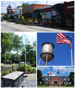
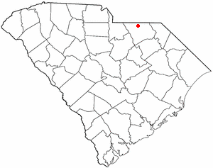
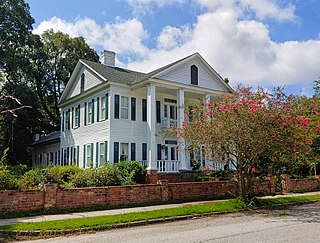
Chesterfield is a town in Chesterfield County, South Carolina, United States. The population was 1,472 at the 2010 census. It is the county seat of Chesterfield County. At the time of the 2010 census, Chesterfield was the least populous of all of South Carolina's county seats.

<span class="mw-page-title-main">Mount Croghan, South Carolina</span> Town in South Carolina, United States

Mount Croghan is a town in Chesterfield County, South Carolina, United States. The population was 195 at the 2010 census, up from 155 in 2000. It houses a Flea market

<span class="mw-page-title-main">Pageland, South Carolina</span> Town in South Carolina, United States

Pageland is a town in Chesterfield County, South Carolina, United States. It is the second largest town in Chesterfield County. The population was 2,760 at the 2010 census.

<span class="mw-page-title-main">Ruby, South Carolina</span> Town in South Carolina, United States

Ruby is a town in Chesterfield County, South Carolina, United States. The population was 360 at the 2010 census.

<span class="mw-page-title-main">Ridgeway, South Carolina</span> Town in South Carolina, United States

Ridgeway is a town in Fairfield County, South Carolina, United States. The population was 319 at the 2010 census. It is part of the Columbia, SC Metropolitan Statistical Area.

<span class="mw-page-title-main">Bethune, South Carolina</span> Town in South Carolina, United States

Bethune is a small town in Kershaw County, South Carolina, United States. The population was 334 at the 2010 census. It is part of the Columbia, South Carolina Metropolitan Statistical Area.

<span class="mw-page-title-main">Kershaw, South Carolina</span> Town in South Carolina, United States

Kershaw is a town in Lancaster County, South Carolina, United States. It was incorporated in 1888. As of the 2010 census, the population was 1,803, and as of 2019 the estimated population was 2,321. The Haile Gold Mine, where gold was discovered in 1825, is 3 miles (5 km) from town and was at one time the largest single producer of gold in the Appalachian region.

Springdale is an unincorporated community and census-designated place (CDP) in Lancaster County, South Carolina, United States. The population was 2,574 at the 2010 census, down from 2,864 at the 2000 census.

<span class="mw-page-title-main">Lynchburg, South Carolina</span> Town in South Carolina, United States

Lynchburg is a town in Lee County, South Carolina, United States. The population was 373 at the 2010 census.

<span class="mw-page-title-main">Dentsville, South Carolina</span> Census-designated place in South Carolina, United States

Dentsville is a census-designated place (CDP) in Richland County, South Carolina, United States. The population was 14,062 at the 2010 census. It is part of the Columbia, South Carolina, Metropolitan Statistical Area.

Harrells is a town in Duplin and Sampson counties, North Carolina, United States. The population was 160 at the 2020 census. At the previous census in 2010, the population was 202.

Broadalbin is a town in Fulton County, New York, on the eastern border of the county and northwest of Albany. The town was named after the Breadalbane Region in Scotland by an early settler. The town contains a village also called Broadalbin. The population was 5,260 at the 2010 census.

References

  1. "ArcGIS REST Services Directory". United States Census Bureau. Retrieved October 15, 2022.
  2. 1 2 U.S. Geological Survey Geographic Names Information System: Great Falls, South Carolina
  3. 1 2 "Census Population API". United States Census Bureau. Retrieved October 15, 2022.
  4. 1 2 "U.S. Census website". United States Census Bureau . Retrieved January 31, 2008.
  5. "National Register Information System". National Register of Historic Places . National Park Service. July 9, 2010.
  6. "Wynne V. Town of Great Falls, South Carolina". 376 F.3d 292 (2004).
  7. "US Gazetteer files: 2010, 2000, and 1990". United States Census Bureau. February 12, 2011. Retrieved April 23, 2011.
  8. "Census of Population and Housing". Census.gov. Retrieved June 4, 2015.
  9. "Explore Census Data". data.census.gov. Retrieved December 14, 2021.
  10. "South Carolina libraries and archives". SCIWAY. Retrieved June 7, 2019.