Great Falls Dam (Tennessee)

Last updated

Great Falls Hydroelectric Station
Great-falls-dam-tva1.jpg
Great Falls Dam
USA Tennessee location map.svg
Red pog.svg
Usa edcp location map.svg
Red pog.svg
Location Warren / White counties, Tennessee, United States
Nearest city Rock Island, Tennessee
Coordinates 35°48′7″N85°37′20″W / 35.80194°N 85.62222°W / 35.80194; -85.62222
Built1915–1916
NRHP reference No. 90001004
Added to NRHP1990

Great Falls Dam is a hydroelectric dam on the Caney Fork, straddling the county line between White County and Warren County in the U.S. state of Tennessee. It is the only dam outside the Tennessee River watershed owned and operated by the Tennessee Valley Authority. The dam impounds the 1,830-acre (740 ha) Great Falls Lake, and its tailwaters feed into Center Hill Lake. [1] The completion of Great Falls Dam in late 1916 was an engineering triumph, marking the first successful attempt to impound the volatile and flood-prone Caney Fork. The dam is also notable for its design, utilizing a mostly underground conduit to carry water from the reservoir via a tributary to the Power House 0.75 miles (1.21 km) downstream from the dam. [2] [3]

Contents

Great Falls Dam is named for the rapids and waterfalls on the Caney Fork downstream from the dam. The section of river below the powerhouse is world-renowned for whitewater kayaking. The dam and its tailwaters are surrounded by Rock Island State Park. [1]

Location

Great Falls Dam is located approximately 94 miles (151 km) above the mouth of the Caney Fork, immediately downstream from the Caney Fork's confluence with the Collins River. The confluence of these two rivers (the Collins flowing from the southwest and the Caney Fork from the east) creates a peninsula. The two rivers nearly meet at the Narrows, a "land bridge" connecting the peninsula to the mainland. Two tunnels measuring approximately 600 feet (180 m) each deliver water from the Collins River section of the Great Falls Reservoir underneath Highway 287 at the Narrows to the dam's powerhouse located on the Caney Fork 0.75 miles (1.21 km) downstream from the dam.

Great Falls Reservoir stretches behind the dam for 22 miles (35 km) along the Caney Fork and for roughly 10 miles (16 km) along the lower Collins River. The lake also includes a small stretch of the lower Rocky River, which empties into the Caney Fork about a mile east of the dam.

Capacity

Great Falls Dam is a concrete gravity diversion type dam 92 feet (28 m) high and 800 feet (240 m) long, and has a generating capacity of 33,800 kilowatts (33.8 MW). [1] The dam's spillway has 18 gates with a combined discharge of 150,000 cubic feet (4,200 m3) per second. [2] [4] Great Falls Reservoir has approximately 49,000 acre-feet (60,000,000 m3) of flood storage, 120 miles (190 km) of shoreline, and 1,830 acres (740 ha) of water surface. [1] [4]

History

Construction work at the Great Falls Dam site, showing the entrance to the dam's diversion tunnel and part of a cofferdam Great-falls-dam-tennessee-construction2.jpg
Construction work at the Great Falls Dam site, showing the entrance to the dam's diversion tunnel and part of a cofferdam

Throughout the 19th century, many attempts were made to harness the extraordinary hydro power potential of the Caney Fork only to be defeated by one of the volatile river's disastrous floods. The first major establishment to utilize the river's power at Great Falls was the Bosson Mill, a gristmill and carding factory that operated at the site across the river from the powerhouse from the 1860s until its destruction by a flood in 1882. [5] The most prominent venture at Great Falls Gorge was the Falls City Cotton Mill Company, which established a cotton mill and company town, Falls City, just above the gorge in 1892. The company turned a moderate profit until 1902, when the Good Friday Flood destroyed its toll bridge and powerhouse, and the mill was forced to close (the mill and the town's "spring castle" are still standing, however). [6]

By 1900, the rise of major industry in Nashville brought an increased demand for electricity. In 1901, Nashville entrepreneur Arthur Dyer formed the Great Falls Power Company and purchased land on the north side of the gorge with plans to build a dam. Dyer had trouble getting financing for the project, however, and in 1912 sold Great Falls Power to the Tennessee Power Company. The original plans called for a dam 110 feet (34 m) high. At the Narrows, where the two tunnels are now located, an open channel was to be made from the Collins River to the Caney Fork. The water was to be carried across the gorge in a steel flume and then in an open canal across Horseshoe Bend, a distance of 1.5 miles (2.4 km). The powerhouse was to be located at least 3 miles (4.8 km) by river below the present powerhouse. In so doing a total head of 235 feet (72 m) would have been available; 110 feet (34 m) at the dam, 75 feet (23 m) between the dam and the present powerhouse and 50 feet (15 m) around horseshoe bend. [7]

Construction of the dam's diversion tunnel Great-falls-dam-tennessee-construction3.jpg
Construction of the dam's diversion tunnel

With financing from Chicago business interests, Tennessee Power began construction work on the dam's foundation. Within a month, however, the Caney Fork burst its banks again, flooding out the project's excavation work and destroying its cofferdams. Tennessee Power struggled with finances but was able to resume construction in 1915, and by late 1916 the 40 feet (12 m) high dam had been completed. The plant went into operation on January 1, 1917. [7]

In 1922, the Tennessee Power Company merged with several other entities to form the Tennessee Electric Power Company (TEPCO). TEPCO tripled the capacity of Great Falls Dam by raising the dam 35 feet (11 m) and installing a second generator at the powerhouse downstream. The dam faced its first major test in March 1929, when several cloudbursts atop the Cumberland Plateau caused the Caney Fork to expand to record flood volumes, sending wreckage and uprooted trees crashing into the dam. The Great Falls Power House was flooded and a substation was destroyed, but the dam held. [7]

The passage of the TVA Act in 1933 gave the Tennessee Valley Authority oversight of flood control operations in the Tennessee River watershed, where most of TEPCO's dams were located. Jo Conn Guild, the head of TEPCO, vehemently opposed TVA and challenged the constitutionality of the TVA Act in federal court. After the U.S. Supreme Court upheld the act, however, TEPCO was forced under eminent domain to sell its assets to TVA for $78 million. This sum included $3.5 million for Great Falls Dam. [2]

After its acquisition, TVA began making improvements to Great Falls Dam. By 1946, grouting work had repaired much of the leakage through the cliffside, which had been an issue since the dam's creation. TVA also built a new switchyard and control building. [2] In the late 1960s, the agency leased part of the Great Falls reservation to the state for the development of Rock Island State Park, which opened in 1969. [8]

Related Research Articles

<span class="mw-page-title-main">Calfkiller River</span> River in Tennessee, United States

The Calfkiller River is a 42.4-mile-long (68.2 km) stream in the east-central portion of Middle Tennessee in the United States. It is a tributary of the Caney Fork, and is part of the Cumberland, Ohio, and Mississippi watersheds. The river is believed to be named for a Cherokee chief who once lived in the area.

<span class="mw-page-title-main">Collins River</span> River in Tennessee, United States

The Collins River is a 67-mile-long (108 km) stream in the east-central portion of Middle Tennessee in the United States. It is a tributary of the Caney Fork, and is part of the Cumberland, Ohio and Mississippi watersheds. The river drains the scenic Savage Gulf area, located just below the river's source, and empties into Great Falls Lake at Rock Island State Park.

<span class="mw-page-title-main">Rocky River (Tennessee)</span> River in Tennessee, United States

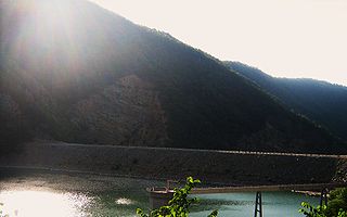
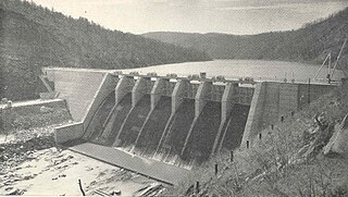
The Rocky River is a 31.0-mile-long (49.9 km) stream in the east-central portion of Middle Tennessee in the United States. It is a tributary of the Caney Fork River, and is part of the Cumberland, Ohio and Mississippi watersheds. The lower portion of the river is part of the reservoir created by Great Falls Dam, which is located near the river's confluence with the Caney Fork.

<span class="mw-page-title-main">Falling Water River</span> River in Tennessee, United States

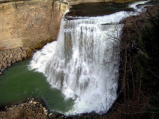
The Falling Water River is a 46.8-mile-long (75.3 km) stream in the east-central portion of Middle Tennessee in the United States. It rises just west of Monterey at the edge of the Cumberland Plateau, and traverses the Eastern Highland Rim before dropping off to the Nashville Basin and emptying into Center Hill Lake along the Caney Fork. The river is noted for the 136-foot (41 m) Burgess Falls, which it spills over near the end of its course.

<span class="mw-page-title-main">Caney Fork River</span> River in Tennessee, United States

The Caney Fork River is a river that flows through central Tennessee in the United States, draining a substantial portion of the southwestern Cumberland Plateau and southeastern Highland Rim regions. It is a major tributary of the Cumberland River, and is part of the Cumberland, Ohio and Mississippi basins. The river is 143 miles (230 km) long, and its watershed covers 1,771 square miles (4,590 km2) in eleven counties. Monterey, Baxter, Sparta, Smithville, McMinnville, Altamont, Spencer and Gordonsville are among the towns that are at least partially drained by the river.

<span class="mw-page-title-main">Fall Creek Falls State Park</span> State park in Tennessee, United States

Fall Creek Falls State Resort Park is a state park in Van Buren and Bledsoe counties, in the U.S. state of Tennessee. The over 30,638-acre (123.99 km2) park is centered on the upper Cane Creek Gorge, an area known for its unique geological formations and scenic waterfalls. The park's namesake is the 256-foot (78 m) Fall Creek Falls, the highest free-fall waterfall east of the Mississippi River.

<span class="mw-page-title-main">Burgess Falls State Park</span> Protected area in Tennessee, US

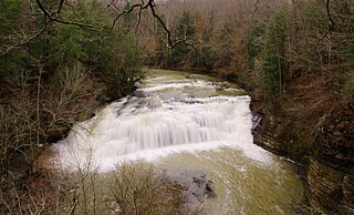
Burgess Falls State Park is a state park and state natural area in Putnam County and White County, Tennessee, located in the southeastern United States. The park is situated around a steep gorge in which the Falling Water River drops 250 feet (76 m) in elevation in less than a mile, culminating in a 136-foot (41 m) cataract waterfall.

<span class="mw-page-title-main">Rock Island State Park (Tennessee)</span> Park in Warren and White Counties, Tennessee, United States

Rock Island State Park is a state park in Warren County and White County, Tennessee, located in the Southeastern United States. The park is named after the community of Rock Island, Tennessee, which in turn received its name from an island on the Caney Fork upstream from the Collins River confluence and Great Falls Dam. Rock Island State Park is centered on a peninsula created by the confluence of these two rivers and extends downstream to the headwaters of Center Hill Lake.

<span class="mw-page-title-main">Edgar Evins State Park</span> State park in Tennessee, United States

Edgar Evins State Park is a state park in DeKalb County, Tennessee, in the southeastern United States. The park consists of 6,300 acres (25 km2) along the shores of Center Hill Lake, an impoundment of the Caney Fork. The State of Tennessee leases the land from the U.S. Army Corps of Engineers.

<span class="mw-page-title-main">Nickajack Dam</span> Dam in Tennessee, United States

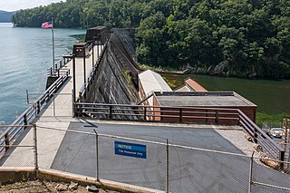
Nickajack Dam is a hydroelectric dam in Marion County in the U.S. state of Tennessee. It is one of nine dams on the Tennessee River owned and operated by the Tennessee Valley Authority, which built the dam in the mid-1960s to replace the outdated Hales Bar Dam 6 miles (9.7 km) upstream. The dam impounds the 10,370-acre (4,200 ha) Nickajack Lake and feeds into Guntersville Lake. Nickajack Dam is named for a Cherokee village once located just upstream from the dam. The village was the namesake for Nickajack Cave, which was partially flooded by the reservoir.

<span class="mw-page-title-main">Hales Bar Dam</span> United States historic place

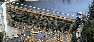
Hales Bar Dam was a hydroelectric dam once located on the Tennessee River in Marion County, Tennessee, United States. The Chattanooga and Tennessee River Power Company began building the dam on October 17, 1905, and completed it on November 11, 1913, making Hales Bar one of the first major multipurpose dams and one of the first major dams to be built across a navigable channel in the United States. It began operation on November 13, 1913.

<span class="mw-page-title-main">Apalachia Dam</span> Dam in North Carolina, United States

Apalachia Dam is a hydroelectric dam on the Hiwassee River in Cherokee County, in the U.S. state of North Carolina. The dam is the lowermost of three dams on the river owned and operated by the Tennessee Valley Authority, which built the dam in the early 1940s to provide emergency power for aluminum production during World War II. While the dam is in North Carolina, an 8.3-mile (13.4 km) underground conduit carries water from the dam's reservoir to the powerhouse located 12 miles (19 km) downstream across the state line in Polk County, Tennessee. The dam and associated infrastructure were listed on the National Register of Historic Places in 2017.

<span class="mw-page-title-main">Calderwood Dam</span> Hydroelectric dam in Tennessee

Calderwood Dam is a hydroelectric dam located along the Little Tennessee River in Blount and Monroe counties, in the U. S. state of Tennessee. Completed in 1930, the dam is owned and maintained by Tapoco, a subsidiary of the Aluminum Company of America (Alcoa), although the Tennessee Valley Authority (TVA) controls the dam's reservoir levels from Fontana Dam further upstream. Calderwood Dam is named for Alcoa engineer Isaac Glidden Calderwood (1871–1941), who supervised much of the company's early Little Tennessee River operations.

<span class="mw-page-title-main">Scott's Gulf</span> Canyon in Tennessee

Scott's Gulf is a canyon situated along the Caney Fork River in White County, Tennessee, in the southeastern United States. The canyon stretches for approximately 18 miles (29 km) as the Caney Fork drops from the top of the Cumberland Plateau down to the eastern Highland Rim. This remote section of the river is home to a wilderness area consisting of a largely undisturbed deciduous forest, numerous waterfalls, caves and other geological formations, and Class IV and Class V whitewater rapids.

<span class="mw-page-title-main">Watauga Dam</span> Dam in Tennessee, United States

Watauga Dam is a hydroelectric and flood control dam on the Watauga River in Carter County, in the U.S. state of Tennessee. It is owned and operated by the Tennessee Valley Authority, which built the dam in the 1940s as part of efforts to control flooding in the Tennessee River watershed. At 318 feet (97 m), Watauga is the second-highest dam in the TVA river and reservoir system, and at the time of its completion was one of the highest earth-and-rock dams in the United States. The dam impounds the TVA Watauga Reservoir of 6,430 acres (2,600 ha), and its tailwaters feed into Wilbur Lake.

<span class="mw-page-title-main">Ocoee Dam No. 1</span> Hydroelectric dam in Tennessee

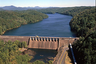
Ocoee Dam Number 1 is a hydroelectric dam on the Ocoee River in Polk County in the U.S. state of Tennessee. The dam impounds the 1,930-acre (780 ha) Parksville Reservoir and is the farthest downstream of four dams on the Toccoa/Ocoee River owned and operated by the Tennessee Valley Authority. Completed in 1911, Ocoee No. 1 was one of the first hydroelectric projects in Tennessee.

<span class="mw-page-title-main">Ocoee Dam No. 2</span> Hydroelectric dam in Tennessee

Ocoee Dam Number 2 is a hydroelectric dam on the Ocoee River in Polk County in the U.S. state of Tennessee. The dam impounds the Ocoee No. 2 Reservoir and is one of three dams on the Toccoa/Ocoee River owned and operated by the Tennessee Valley Authority. It was completed in 1913.

<span class="mw-page-title-main">Blue Ridge Dam</span> Dam in Georgia, United States

Blue Ridge Dam is a hydroelectric dam on the Toccoa River in Fannin County, in the U.S. state of Georgia. It is the uppermost of four dams on the Toccoa/Ocoee River owned and operated by the Tennessee Valley Authority. The dam impounds the 3,300-acre (1,300 ha) Blue Ridge Lake on the southwestern fringe of the Blue Ridge Mountains.

<span class="mw-page-title-main">Ocoee Dam No. 3</span> Dam in Tennessee, United States

Ocoee Dam No. 3 is a hydroelectric dam on the Ocoee River in Polk County, in the U.S. state of Tennessee. It is one of four dams on the Toccoa/Ocoee River owned and operated by the Tennessee Valley Authority, which built the dam in the early 1940s to meet emergency demands for electricity during World War II. The dam impounds the 360-acre (150 ha) Ocoee No. 3 Reservoir, which stretches 11 miles (18 km) upriver to the Tennessee-Georgia state line. Ocoee No. 3's powerhouse is actually located several miles downstream from the dam, and is fed by a 2.5-mile (4.0 km) conduit that carries water to it from the reservoir.

<span class="mw-page-title-main">South Holston Dam</span> Dam in Tennessee, United States

South Holston Dam is a hydroelectric and flood control dam on the South Fork Holston River in Sullivan County, in the U.S. state of Tennessee. It is the uppermost of three dams on the South Fork Holston owned and operated by the Tennessee Valley Authority, which built the dam in the 1940s as part of efforts to control flooding in the Tennessee River watershed. On October 21, 1950 the valve gate closed and water began backing up to create South Holston Reservoir. Work began on the dam in December 1941, but in November 1942, the War Production Board requested that the operation be suspended because of a shortage of critical materials. Work did not resume until July 1, 1947. The dam now impounds the South Holston Lake of 7,550 acres (3,060 ha), which extends northeastward across the Tennessee-Virginia state line.

References

  1. 1 2 3 4 Tennessee Valley Authority, Great Falls Reservoir. Retrieved: January 29, 2009.
  2. 1 2 3 4 Tennessee Valley Authority, Design of TVA Projects Volume 3: Mechanical Design of Hydro Plants, Technical Report No. 24 (Washington, D.C.: Tennessee Valley Authority, 1952), pp. 301-302.
  3. Distance measured from Campaign Quadrangle - Tennessee (Map). 1 : 24,000. 7,5 Minute Series (Topographic). United States Geological Survey. 1981. ISBN   978-0-607-49059-6. and Doyle Quadrangle - Tennessee (Map). 1 : 24,000. 7,5 Minute Series (Topographic). United States Geological Survey. 1981. ISBN   978-0-607-49147-0.
  4. 1 2 Tennessee Valley Authority, The Nickajack Project: A Report on the Planning, Design, Construction, Initial Operations, and Costs, Technical Report No. 16 (Knoxville, Tenn.: Tennessee Valley Authority, 1972), pp. 10-11.
  5. Crouch, Arthur Weir (March 1973). The Caney Fork of the Cumberland. Nashville: Crouch. pp. 38–41. ASIN   B0006W7JUG. OCLC   1973065 . Retrieved May 12, 2011.
  6. Crouch, Arthur Weir (March 1973). The Caney Fork of the Cumberland. Nashville: Crouch. pp. 45–41. ASIN   B0006W7JUG. OCLC   1973065 . Retrieved May 12, 2011.
  7. 1 2 3 Crouch, Arthur Weir (March 1973). The Caney Fork of the Cumberland. Nashville: Crouch. pp. 52–62. ASIN   B0006W7JUG. OCLC   1973065 . Retrieved May 12, 2011.
  8. Tennessee State Parks, Rock Island State Park official park brochure. Retrieved: January 29, 2009. PDF.