
The Republican River is a river in the central Great Plains of North America, rising in the High Plains of eastern Colorado and flowing east 453 miles (729 km) through the U.S. states of Nebraska and Kansas.
The Great Flood of 1993 was a flood that occurred in the Midwestern United States, along the Mississippi and Missouri rivers and their tributaries, from April to October 1993. The flood was among the most costly and devastating to ever occur in the United States, with $15 billion in damages. The hydrographic basin affected an area approximately 745 miles (1,199 km) in length and 435 miles (700 km) in width, totaling about 320,000 square miles (830,000 km2). Within this zone, the flooded area totaled around 30,000 square miles (78,000 km2) and was the worst such U.S. disaster since the Great Mississippi Flood of 1927, as measured by duration, area inundated, persons displaced, crop and property damage, and number of record river levels. In some categories, the 1993 flood even surpassed the 1927 flood, at the time the largest flood ever recorded on the Mississippi River.
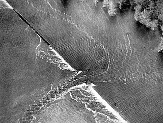
A levee breach or levee failure is a situation where a levee fails or is intentionally breached, causing the previously contained water to flood the land behind the levee.

The Marais des Cygnes River is a principal tributary of the Osage River, about 217 miles (349 km) long, in eastern Kansas and western Missouri in the United States. Via the Osage and Missouri rivers, it is part of the watershed of the Mississippi River.

Tuttle Creek Lake is a reservoir on the Big Blue River 5 miles (8 km) north of Manhattan, in the Flint Hills region of northeast Kansas. It was built and is operated by the Army Corps of Engineers for the primary purpose of flood control. Secondary functions of the project include release of water stores to maintain barge traffic on the Mississippi River during seasons of drought, maintenance of a multi-use conservation pool for fish and wildlife enhancement and recreation, and release of sufficient water in droughts to maintain water quality for downstream communities.
Floods in the United States are generally caused by excessive rainfall, excessive snowmelt, and dam failure. Below is a list of flood events that were of significant impact to the country during the 20th century, from 1900 through 1999, inclusive.
The Great Flood of 1844 is the biggest flood ever recorded on the Missouri River and Upper Mississippi River, in North America, in terms of discharge. The adjusted economic impact was not as great as subsequent floods because of the small population in the region at the time. The flood devastation was particularly widespread since the region had few levees at the time, so the waters were able to spread far from the normal banks. Among the hardest hit in terms of mortality were the Wyandot Indians, who lost 100 people in the diseases that occurred after the flood in the vicinity of today's Kansas City, Kansas.

The Ohio River flood of 1937 took place in late January and February 1937. With damage stretching from Pittsburgh to Cairo, Illinois, 385 people died, one million people were left homeless and property losses reached $500 million. Federal and state resources were strained to aid recovery as the disaster occurred during the depths of the Great Depression and a few years after the beginning of the Dust Bowl.
The Rock Island Bridge in Kansas City, Kansas is a rail crossing of the Kansas River. It connects the Armourdale, Kansas to West Bottoms. It is a truss bridge that is closed to traffic.
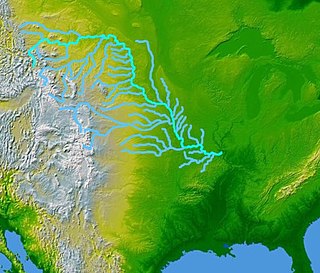
The Missouri River Valley outlines the journey of the Missouri River from its headwaters where the Madison, Jefferson and Gallatin Rivers flow together in Montana to its confluence with the Mississippi River in the State of Missouri. At 2,300 miles (3,700 km) long the valley drains one-sixth of the United States, and is the longest river valley on the North American continent. The valley in the Missouri River basin includes river bottoms and floodplains.

The June 2008 Midwestern United States floods were flooding events which affected portions of the Midwestern United States. After months of heavy precipitation, a number of rivers overflowed their banks for several weeks at a time and broke through levees at numerous locations. Flooding continued into July. States affected by the flooding included Illinois, Indiana, Iowa, Michigan, Minnesota, Missouri and Wisconsin. The American Red Cross assisted the victims of flooding and tornadoes across seven states and the National Guard was mobilized to assist in disaster relief and evacuation.

Milford Lake, also known as Milford Reservoir, is the largest man-made lake in Kansas with 15,700 acres (64 km2) of water. Over 33,000 acres (130 km2) of land resources are managed for quality recreational experiences as well as for protection of the project’s natural and cultural resources. Approximately 70% of the land resources are available for public hunting.

The Christmas flood of 1964 was a major flood in the United States' Pacific Northwest and some of Northern California between December 18, 1964, and January 7, 1965, spanning the Christmas holiday. Considered a 100-year flood, it was the worst flood in recorded history on nearly every major stream and river in coastal Northern California and one of the worst to affect the Willamette River in Oregon. It also affected parts of southwest Washington, Idaho, and Nevada. In Oregon, 17 or 18 people died as a result of the disaster, and it caused hundreds of millions of dollars in damage. The flooding on the Willamette covered 152,789 acres (61,831.5 ha). The National Weather Service rated the flood as the fifth most destructive weather event in Oregon in the 20th century. California Governor Pat Brown was quoted as saying that a flood of similar proportions could "happen only once in 1,000 years," and it was often referred to later as the Thousand Year Flood. The flood killed 19 people, heavily damaged or completely devastated at least 10 towns, destroyed all or portions of more than 20 major highway and county bridges, carried away millions of board feet of lumber and logs from mill sites, devastated thousands of acres of agricultural land, killed 4,000 head of livestock, and caused $100 million in damage in Humboldt County, California, alone.
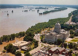
Major floods along the Mississippi River in April and May 2011 were among the largest and most damaging recorded along the U.S. waterway in the past century, comparable in extent to the Great Mississippi Flood of 1927 and Great Flood of 1993. In April 2011, two large storm systems deposited record levels of rainfall on the Mississippi River drainage basin. When that additional water combined with the springtime snowmelt, the river and many of its tributaries began to swell to record levels by the beginning of May. Flooding occurred in Illinois, Missouri, Kentucky, Tennessee, Arkansas, Mississippi, and Louisiana.

The 2011 Missouri River floods was a flooding event on the Missouri River in the United States.The flooding was triggered by record snowfall in Rocky Mountains of Montana and Wyoming along with near-record spring rainfall in central and eastern Montana. All six major dams along the Missouri River released record amounts of water to prevent overflow which led to flooding threatening several towns and cities along the river from Montana to Missouri; in particular Bismarck, North Dakota; Pierre, South Dakota; Dakota Dunes, South Dakota; South Sioux City, Nebraska, Sioux City, Iowa; Omaha, Nebraska; Council Bluffs, Iowa; Saint Joseph, Missouri; Kansas City, Missouri; Jefferson City, Missouri, and St. Louis, Missouri. Many smaller towns were also at risk, suffering the same fate as the larger cities if not worse. According to the National Weather Service, in the second half of the month of May 2011, almost a year's worth of rain fell over the upper Missouri River basin. Extremely heavy rainfall in conjunction with an estimated 212 percent of normal snowpack in the Rocky Mountains contributed to this flooding event.

Shadehill Dam is a dam on the Grand River in Perkins County in northwestern South Dakota in the United States, about 10 miles (16 km) south of Lemmon. The dam and its impoundment, Shadehill Reservoir, serve mainly for flood and silt control, wildlife conservation and recreation. Located directly below the confluence of the North and South Forks of the Grand River, the dam is operated by the U.S. Bureau of Reclamation, and is part of the Shadehill Unit of the Pick-Sloan Missouri Basin Program.
Floods in Colorado include the flood of 1844 which filled the South Platte valley from "bluff to bluff" to the recent Denver floods of 1965 and the 2013 Colorado floods.

Flooding in the Mississippi River Basin during the winter, spring, and summer of 2019 caused at least 12 deaths and economic losses in 19 states totaling in excess of $20 billion. Estimated damages in the Midwestern United States alone had reached $12.5 billion by April 2019. Flood damages totaling $6.2 billion were reported in the 11 states bordering the Mississippi River. In addition to property and crop losses and infrastructure damages, commercial navigation on the Mississippi River was interrupted repeatedly by high currents, low bridge clearances, and closed locks. This delayed shipments of agricultural commodities, adding to the economic stress of crop losses caused by flooding. As of late April 2019, shipments of corn to export terminals in Louisiana were 31% lower than in same period in 2018.

Between May and June 2019, an extended sequence of heavy rainfall events over the South Central United States caused historic flooding along the Arkansas River and its tributaries. Major and record river flooding occurred primarily in northeastern Oklahoma, and the elevated flows continued downstream into Arkansas where they caused additional inundation. Antecedent soil moisture levels and water levels in lakes and streams were already high from previous rains, priming the region for significant runoff and flooding. The prolonged combination of high atmospheric moisture and a sustained weather pattern extending across the continental United States led to frequent high-yield rainfall over the Arkansas River watershed. The overarching weather pattern allowed moisture levels to quickly rebound after each sequential rainfall episode. With soils already saturated, the excess precipitation became surface runoff and flowed into the already elevated lakes and streams. Most rainfall occurred in connection with a series of repeated thunderstorms between May 19–21, which was then followed by additional rains that kept streams within flood stage.

