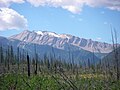
The Flathead Range is a mountain range of the Northern Rocky Mountains located southeast of Whitefish, Montana in the Great Bear Wilderness, part of the Bob Marshall Wilderness Complex. It is west of the Rocky Mountain Front, east of the Swan Range and southeast of the Whitefish Range. Its west side is drained by the South Fork Flathead River which forms Hungry Horse Reservoir.

Rampage Mountain is a summit in Flathead County, Montana, in the United States. With an elevation of 6,855 feet (2,089 m), Rampage Mountain is the 1675th highest summit in the state of Montana. It is situated within Glacier National Park.

Stanton Mountain is a 7,750 feet (2,360 m) mountain summit located in the Livingston Range, of Glacier National Park in the U.S. state of Montana. Stanton Mountain rises more than 4,500 feet (1,400 m) above the northern shore of Lake McDonald. The mountain's name refers to Mrs. Lottie Stanton who lived near the west side of the park in the late 1800s, and with her husband operated a livery stable in historic Demersville. She was a pioneering woman who followed the construction camps during the railroad building days. The mountain's name was officially adopted in 1929. In the late 1800s it was known as Mt. Lottie Stanton. The nearest higher peak is Mount Vaught, 1.38 miles (2.22 km) to the northeast. Precipitation runoff from the mountain drains into tributaries of the Flathead River.

Black Giant is a 13,330-foot-elevation (4,060-meter) mountain summit located west of the crest of the Sierra Nevada mountain range, in Fresno County of central California, United States. Black Giant ranks as the 86th highest summit in California. It is the northernmost and highest summit on its namesake ridge, the Black Divide in northern Kings Canyon National Park. The peak is situated 3.9 miles (6.3 km) east of Mount Goddard, and 2.6 miles (4.2 km) south-southeast of Mount Fiske, which is the nearest higher neighbor. Topographic relief is significant as it rises 4,000 feet above Le Conte Canyon in approximately two miles. Muir Pass is 1.4 miles (2.3 km) to the northwest, and the approach to this remote peak is made via the John Muir Trail.

Calf Robe Mountain is a 7,948-foot-elevation (2,423-meter) mountain summit located in Glacier National Park in the U.S. state of Montana. It is situated on the Continental Divide in the Lewis Range, and can be seen from Highway 2 midway between Marias Pass and East Glacier Park. The summit is set on the border shared by Flathead County and Glacier County. Topographic relief is significant as the east aspect rises 2,500 feet in one mile. The immediate area between the mountain and highway is known for its aspen and beaver dams.

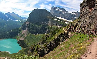
The Dragons Tail is an 8,580-foot (2,620-meter) elevation ridge located in the Lewis Range, of Glacier National Park in the U.S. state of Montana. It is situated on the Continental Divide, on the border shared by Flathead County and Glacier County. Topographic relief is significant as the north aspect rises 2,200 feet above Hidden Lake in one-half mile, and the west aspect rises nearly 4,700 feet above Avalanche Lake in two miles. It can be seen from the Hidden Lake overlook along with its nearest higher neighbor, Bearhat Mountain, 1.27 miles (2.04 km) to the northwest.
Angel Wing is a 7,430-foot (2,260-meter) elevation mountain summit located in the Lewis Range, of Glacier National Park in the U.S. state of Montana. It is situated one mile east of the Continental Divide, in Glacier County. It can be seen from the Many Glacier area, and up close from the Grinnell Glacier Trail. Topographic relief is significant as the north aspect rises nearly 2,500 feet above Grinnell Lake in one-half mile.

Red Crow Mountain is a 7,891-foot-elevation (2,405-meter) mountain summit located in Glacier National Park in the U.S. state of Montana. The summit is set on the border shared by Flathead County and Glacier County. It is situated on the Continental Divide so precipitation runoff from the east side of the mountain drains into Railroad Creek which is part of the Two Medicine River watershed, and the west side drains to Ole Creek, which is a tributary of Middle Fork Flathead River. It is set in the Lewis Range, 6.5 miles southwest of East Glacier Park Village. Topographic relief is significant as the east aspect rises approximately 2,000 feet in one mile. The nearest higher neighbor is Calf Robe Mountain 1.2 mile to the southeast, with Firebrand Pass forming the saddle between these two peaks.

Haystack Butte is a 7,486-foot-elevation (2,282-meter) summit located in the Lewis Range, of Glacier National Park in the U.S. state of Montana. It is situated one mile west of the Continental Divide, in Flathead County, above the Weeping Wall on its south slope. Topographic relief is significant as the west aspect rises 3,900 feet above McDonald Creek in less than 1.5 mile. It can be seen from Logan Pass, and from Going-to-the-Sun Road which traverses the west and south slopes of the peak. The nearest higher neighbor is Mount Gould, 1.07 miles (1.72 km) to the northeast. Climbing access is via the Highline Trail. This geographical feature's descriptive name was on maps as early as 1904, and was officially adopted March 6, 1929, by the United States Board on Geographic Names

Clyde Peak is an 8,610-foot-elevation (2,620-meter) mountain summit located in Glacier National Park in the U.S. state of Montana. The mountain straddles the border shared by Flathead County and Glacier County. It is situated on the Continental Divide so precipitation runoff from the west side of the mountain drains into Thompson Creek which is part of the Middle Fork Flathead River watershed, and the east side drains into headwaters of Red Eagle Creek, which flows to Red Eagle Lake, thence Saint Mary Lake. It is set in the Lewis Range, and the nearest higher neighbor is Mount Logan 1.44 mile to the northwest. Topographic relief is significant as the southwest aspect rises approximately 4,000 feet in one mile.
Elk Mountain is a 7,835-foot-elevation (2,388-meter) mountain summit located in Flathead County in the U.S. state of Montana. It is situated in the southern tip of Glacier National Park, in the Lewis Range, about four miles to the west side of the Continental Divide. US Highway 2 and the Hi-Line Subdivision of the BNSF Railway traverse the southern base of this mountain, approximately four miles west of Marias Pass. Topographic relief is significant as the northwest aspect rises 3,400 feet above Ole Creek in one mile. The nearest higher neighbor is Sheep Mountain 2.7 miles to the north-northwest. The mountain's name first appeared on a 1914 USGS map, and was officially adopted in 1929 by the United States Board on Geographic Names. The summit is the site of a former fire lookout that was built in the 1930s, and removed in 1963.
Scenic Point is a 7,522-foot-elevation (2,293-meter) mountain summit located in the Two Medicine area of Glacier National Park, in Glacier County, Montana, United States. It is situated in the Lewis Range, six miles northwest of East Glacier Park Village, and approximately seven miles east of the Continental Divide, with precipitation runoff from the mountain draining into the Two Medicine River watershed. Topographic relief is significant as the north aspect rises over 2,600 feet above Lower Two Medicine Lake in one mile. Access to the summit is via the Continental Divide National Scenic Trail which traverses the upper slopes of this mountain. The trail to Scenic Point was constructed by the Great Northern Railway, and the summit once hosted a locomotive bell, a Swiss Alps tradition. The mountain's name was officially adopted in 1929 by the United States Board on Geographic Names.

Porcupine Ridge is a prominent mountain ridge located in the Goat Haunt area of Glacier National Park, in Glacier County of the U.S. state of Montana. This mountain is part of the Livingston Range, and is situated 1.5 mile east of the Continental Divide. Topographic relief is significant as the summit rises approximately 3,900 feet above Lake Frances in one mile, and nearly 5,000 feet above Waterton Lake in five miles. Precipitation runoff from the mountain drains to the Waterton River via Olson and Valentine Creeks. This geographical feature's name was officially adopted in 1911 by the United States Board on Geographic Names.

Pentagon Mountain is an 8,873-foot (2,704-metre) mountain summit located in Flathead County of the U.S. state of Montana.

Gable Peaks is a remote 7,700-foot (2,347-metre) double summit mountain located in Flathead County of the U.S. state of Montana.

Union Mountain is a 7,601-foot (2,317-metre) summit located in Flathead County of the U.S. state of Montana.

Jumbo Mountain is an 8,284-foot (2,525-metre) mountain summit located in Powell County of the U.S. state of Montana.

Mount Grant is an 8,590-foot-elevation (2,618 meter) mountain summit located in Flathead County in the U.S. state of Montana.

Glacier Peak is a 9,495-foot elevation (2,894 m) mountain summit located in Union County, Oregon, US.

Chiefs Head Peak is a 13,577-foot-elevation (4,138-meter) mountain summit in Boulder County, Colorado, United States.