Great Recycling and Northern Development Canal

Last updated
Map of GRAND (left) compared with map of the North American Water and Power Alliance (right), a continental water management scheme of similar scale ComparisonGCNA-NAWAPA1.gif
Map of GRAND (left) compared with map of the North American Water and Power Alliance (right), a continental water management scheme of similar scale
Map of North America showing fresh water runoff. Note that 20% of the runoff flows into Hudson-James Bay where less than 1% of the population live. North American Fresh Water Run-Off2.png
Map of North America showing fresh water runoff. Note that 20% of the runoff flows into Hudson-James Bay where less than 1% of the population live.
Possible scenario of the GRAND Canal scheme, showing the initial water capture and diversion into Lake Huron. Water would be pumped south from the newly formed James Lake into the Harricana River, crossing into the Great Lakes watershed near Amos, into Lake Timiskaming and the Ottawa River, crossing near Mattawa into Lake Nipissing and the French River to Lake Huron. GRAND Canal proposal (James Bay to Lake Huron).jpg
Possible scenario of the GRAND Canal scheme, showing the initial water capture and diversion into Lake Huron. Water would be pumped south from the newly formed James Lake into the Harricana River, crossing into the Great Lakes watershed near Amos, into Lake Timiskaming and the Ottawa River, crossing near Mattawa into Lake Nipissing and the French River to Lake Huron.

The Great Recycling and Northern Development Canal or GRAND Canal is a water management proposal designed by Newfoundland engineer Thomas Kierans to alleviate North American freshwater shortage problems. It proposed damming James Bay, using the techniques of the Zuiderzee/IJsselmeer, to prevent its waters mixing with the salt water of Hudson Bay to the north. This would produce an enormous freshwater lake, some of which would be pumped south into Georgian Bay where it would increase the freshwater levels of the lower Great Lakes. The flow would be roughly equivalent to "2.5 Niagara Falls".

Contents

The plan was promoted by Kierans from 1959 until his death in 2013 and since by his son, Michael Kierans. This plan arose as water quality issues threatened the Great Lakes and other vital areas in Canada and the United States. [1] Kierans proposed that to avoid a water crisis from future droughts in Canada and the United States, in addition to water conservation, acceptable new fresh water sources had to be found.

During the 1960s and again in the 1980s when Great Lake water levels declined dramatically, there was interest in the GRAND Canal. However, the reluctance of the US and Canadian governments to enter into large scale co-operative international water sharing arrangements and claims of potential negative environmental impact of the proposal have prevented serious consideration of the idea.

Background

In 1959, Canada officially claimed that U.S. expansion of a Chicago diversion from Lake Michigan would harm downstream Canadian areas in the Great Lakes Basin.

The Canadian government further stated that exhaustive studies had indicated no additional sources of freshwater were available in Canada to replace the waters that would be removed from the Great Lakes by the proposed diversion. Kierans disputed the accuracy of the 1959 Canadian government's position and asserted that the GRAND Canal could provide additional fresh water to the Great Lakes.

Waters from the Ogoki River and Longlac are now being diverted into the Great Lakes at a rate equivalent to that taken by the U.S. at the Chicago diversion. [2]

Proposal

In his proposal, Kierans asserts that experience in the Netherlands demonstrates that a large new freshwater source can be created in Canada's James Bay by collecting runoff from many adjacent river basins in a sea level, outflow-only dyke-enclosure. The project would capture and make available for recycling the entire outflows of the La Grande, Eastmain, Rupert, Broadback, Nottaway, Harricana, Moose, Albany, Kapiskau, Attawapiskat and Ekwan rivers. [3] Moreover, Kierans claims that the California Aqueduct proves that runoff to James Bay can be beneficially recycled long distances and over high elevations via the GRAND Canal. The GRAND Canal would stabilize water levels in the Great Lakes and St. Lawrence River and improve water quality. The GRAND Canal system would also deliver new fresh water from the James Bay dyke-enclosure, via the Great Lakes, to many water deficit areas in Canada and the United States. The project was estimated in 1994 to cost C$100 billion to build and a further C$1 billion annually to operate, involving a string of nuclear reactors and hydroelectric dams to pump water uphill and into other water basins.

Benefits and costs

Kierans argues recycling runoff from a dike-enclosure in Canada's James Bay is not harmful and can bring both nations many useful benefits including:

  1. More fresh water for Canada and the United States to stabilize Great Lakes and St. Lawrence water levels and to relieve water shortages and droughts in western Canada and in the south-west U.S. and in particular to halt the depletion and start the replenishment of the Ogallala Aquifer via water export;
  2. Improved fisheries and shipping in Hudson Bay. Oceanographer Professor Max Dunbar pointed out in his paper "Hudson Bay has too much fresh water" [4] that as a result of its low salinity Hudson Bay currently "offers no possibilities for commercial fisheries". By recycling the fresh water runoff from James Bay south to the Great Lakes and away from Hudson's Bay the GRAND Canal will increase Hudson Bay's now harmfully low salinity and consequently improve the commercial fisheries. Increasing the salinity of Hudson Bay will also have the benefit of reducing the freeze-over period during the winter and thereby lengthen the navigation season in Hudson Bay;
  3. Improved Great Lakes water quality due to the increased flows;
  4. Increased electricity available for alternate uses and lowered user cost of electricity by integrating water transfer energy needs with peak power demand;
  5. Enhanced flood controls; [5]
  6. Improved forest fire protection for both nations; [6]
  7. The construction and operation of the GRAND Canal would provide economic stimulus to create employment and avoid recession. This would be similar to the economic stimulus that the Tennessee Valley Authority development and other public works had in the 1930s to start the recovery from the Great Depression.

According to Kierans, project organization to recycle runoff from James Bay Basin could be like that for the St. Lawrence Seaway. Capital costs for about 160 million users will exceed $100 billion. But, he claims, "before construction is completed, the total value of social, ecologic and economic benefits in Canada and the U.S. will surpass the project's costs."

Developments

The GRAND Canal proposal attracted the attention of former Québec premier Robert Bourassa and former prime minister of Canada Brian Mulroney. By 1985, Bourassa and several major engineering companies endorsed detailed GRAND Canal concept studies; [7] however, these concept studies have not proceeded in part because of opposition based on the potential environmental impact of the plan.

Environmental concerns

The GRAND Canal scheme could alter the breeding grounds of the critically endangered Eskimo curlew. Exteskimocurlewlafboa.jpg
The GRAND Canal scheme could alter the breeding grounds of the critically endangered Eskimo curlew.

Some potential environmental impacts of this proposal that would require study prior to its implementation include:

  1. Later ice formation, and earlier ice breakup outside the dike corresponding to an opposite change in the fresh waters inside;
  2. Diminished ecological productivity, possibly as far away as the Labrador Sea;
  3. Fewer nutrients being deposited into Hudson Bay during spring melts;
  4. Removal of James Bay's dampening effect on tidal and wind disturbances; and
  5. Adversely affected migratory bird populations. [8]

The reduced freshwater flow into Hudson Bay will alter the salinity and stratification of the bay, possibly impacting primary production in Hudson Bay, along the Labrador coast, and as far away as the fishing grounds in the Grand Banks of Newfoundland, the Scotian Shelf, and Georges Bank.

If the James Bay dike is built, "Virtually all marine organisms would be destroyed [in the newly formed lake]". [9] Freshwater species would move in, but northern reservoirs tend to fail to produce viable fisheries. The inter-basin connections would be ideal vectors for invasive species to invade new waters.

The construction of a dike across James Bay could negatively impact many mammal species, including ringed and bearded seals, walruses, and bowhead whales, as well as vulnerable populations of polar bears and beluga whales. The impacts would also affect many species of migratory bird, including lesser snow geese, Canada geese, black scoters, brants, American black ducks, northern pintails, mallards, American wigeons, green-winged teals, greater scaups, common eiders, red knots, dunlins, black-bellied, American goldens, and semipalmated plovers, greater and lesser yellowlegs, sanderlings, many species of sandpipers, whimbrels, and marbled godwits, as well as the critically endangered Eskimo curlew. [8]

Social concerns

The project is expected to cost C$100 billion to implement, and a further C$1 billion a year to operate. Most of the water diverted would be exported to the U.S.[ citation needed ]

In addition, the shoreline communities of Attawapiskat, Kashechewan, Fort Albany, Moosonee and Moose Factory in Ontario, and Waskaganish, Eastmain, Wemindji and Chisasibi in Quebec would be forced to relocate.[ citation needed ]

Conspiracy theory

In the 1990s, Canadian conspiracy theorists believed the "GRAND Canal" was part of a conspiracy to end Canadian sovereignty and force it into a union with the U.S. and Mexico. [10] Conspiracy theorists believed that forces interested in a North American Union would agitate for Quebec separation, which would then touch off a Canadian civil war and plunge the Canadian economy into a depression. Impoverished Canadians would then look to the canal project and North American Union to revitalize the Canadian economy. [11] Much of the scenario was lifted from Lansing Lamont's 1994 book Breakup: The Coming End of Canada and the Stakes for America. [12]

Allegedly masterminding this conspiracy was Simon Reisman, [13] ostensibly a Freemason. [14]

See also

Related Research Articles

<span class="mw-page-title-main">Brackish water</span> Water with salinity between freshwater and seawater

Brackish water, sometimes termed brack water, is water occurring in a natural environment that has more salinity than freshwater, but not as much as seawater. It may result from mixing seawater and fresh water together, as in estuaries, or it may occur in brackish fossil aquifers. The word comes from the Middle Dutch root brak. Certain human activities can produce brackish water, in particular civil engineering projects such as dikes and the flooding of coastal marshland to produce brackish water pools for freshwater prawn farming. Brackish water is also the primary waste product of the salinity gradient power process. Because brackish water is hostile to the growth of most terrestrial plant species, without appropriate management it is damaging to the environment.

<span class="mw-page-title-main">Great Lakes</span> Group of lakes in North America

The Great Lakes, also called the Great Lakes of North America, are a series of large interconnected freshwater lakes in the mid-east region of North America that connect to the Atlantic Ocean via the Saint Lawrence River. There are five lakes, which are Superior, Michigan, Huron, Erie, and Ontario and are in general on or near the Canada–United States border. Hydrologically, lakes Michigan and Huron are a single body joined at the Straits of Mackinac. The Great Lakes Waterway enables modern travel and shipping by water among the lakes.

<span class="mw-page-title-main">Great Salt Lake</span> Salt lake in Utah, United States

The Great Salt Lake is the largest saltwater lake in the Western Hemisphere and the eighth-largest terminal lake in the world. It lies in the northern part of the U.S. state of Utah and has a substantial impact upon the local climate, particularly through lake-effect snow. It is a remnant of Lake Bonneville, a prehistoric body of water that covered much of western Utah.

<span class="mw-page-title-main">Hudson Bay</span> Large body of saltwater in northeastern Canada

Hudson Bay, sometimes called Hudson's Bay, is a large body of saltwater in northeastern Canada with a surface area of 1,230,000 km2 (470,000 sq mi). It is located north of Ontario, west of Quebec, northeast of Manitoba and southeast of Nunavut, but politically entirely part of Nunavut. It is an inland marginal sea of the Arctic Ocean. It drains a very large area, about 3,861,400 km2 (1,490,900 sq mi), that includes parts of southeastern Nunavut, Alberta, Saskatchewan, Ontario, Quebec, all of Manitoba, and parts of the U.S. states of North Dakota, South Dakota, Minnesota, and Montana. Hudson Bay's southern arm is called James Bay.

<span class="mw-page-title-main">James Bay</span> Bay on the southern end of the Hudson Bay, Canada

James Bay is a large body of water located on the southern end of Hudson Bay in Canada. Both bodies of water extend from the Arctic Ocean, of which James Bay is the southernmost part. Despite bordering the Canadian provinces of Quebec and Ontario, the bay and the islands within it, the largest of which is Akimiski Island, are politically part of Nunavut.

<span class="mw-page-title-main">Salton Sea</span> Shallow saline lake in southern California

The Salton Sea is a shallow, landlocked, highly saline body of water in Riverside and Imperial counties at the southern end of the U.S. state of California. It lies on the San Andreas Fault within the Salton Trough, which stretches to the Gulf of California in Mexico.

<span class="mw-page-title-main">Lake Okeechobee</span> Natural freshwater lake in Florida, United States

Lake Okeechobee, also known as Florida's Inland Sea, is the largest freshwater lake in the U.S. state of Florida. It is the tenth largest natural freshwater lake among the 50 states of the United States and the second-largest natural freshwater lake contained entirely within the contiguous 48 states, after Lake Michigan.

<span class="mw-page-title-main">Devils Lake (North Dakota)</span> Lake in North Dakota, United States

Devils Lake is a lake in the U.S. state of North Dakota. It is the largest natural body of water and the second-largest body of water in North Dakota after Lake Sakakawea. It can reach a level of 1,458 ft (444 m) before naturally flowing into the Sheyenne River via the Tolna Coulee. On June 27, 2011, it reached an unofficial historical high elevation of 1,454.3 ft (443.3 m). The cities of Devil's Lake and Minnewaukan take their name from the lake as does the Spirit Lake Reservation, which is located on the lake's southern shores.

<span class="mw-page-title-main">James Bay Project</span>

The James Bay Project refers to the construction of a series of hydroelectric power stations on the La Grande River in northwestern Quebec, Canada by state-owned utility Hydro-Québec, and the diversion of neighbouring rivers into the La Grande watershed. It is located between James Bay to the west and Labrador to the east, and its waters flow from the Laurentian Plateau of the Canadian Shield. The project covers an area the size of New York State and is one of the largest hydroelectric systems in the world. It has cost upwards of US$20 billion to build and has an installed generating capacity of 15,244 megawatts, at the cost of 7,000 square miles of Cree hunting lands. If fully expanded to include all of the original planned dams, as well as the additional James Bay II projects, the system would generate a total of 27,000 MW, making it the largest hydroelectric system in the world. It has been built since 1974 by James Bay Energy (SDBJ) for Hydro-Québec.

<span class="mw-page-title-main">Tidal marsh</span> Marsh subject to tidal change in water

A tidal marsh is a marsh found along rivers, coasts and estuaries which floods and drains by the tidal movement of the adjacent estuary, sea or ocean. Tidal marshes experience many overlapping persistent cycles, including diurnal and semi-diurnal tides, day-night temperature fluctuations, spring-neap tides, seasonal vegetation growth and decay, upland runoff, decadal climate variations, and centennial to millennial trends in sea level and climate.

<span class="mw-page-title-main">Robert-Bourassa generating station</span> Hydroelectric power station in Québec, Canada

The Robert-Bourassa generating station, formerly known as La Grande-2 (LG-2), is a hydroelectric power station on the La Grande River that is part of Hydro-Québec's James Bay Project in Canada. The station can generate 5,616 MW and its 16 units were gradually commissioned between 1979 and 1981. Annual generation is in the vicinity of 26500 GWh.

Thomas William Kierans, FCSCE, P. Eng. was an engineer. He was the originator and principal proponent of the Great Recycling and Northern Development Canal or GRAND Canal.

<span class="mw-page-title-main">St. Lucie River</span> River in the United States of America

The St. Lucie River is a 35-mile-long (56 km) estuary linked to a coastal river system in St. Lucie and Martin counties in the Florida, United States. The St. Lucie River and St. Lucie Estuary are an "ecological jewel" of the Treasure Coast, central to the health and well-being of the surrounding communities. The river is part of the larger Indian River Lagoon system, the most diverse estuarine environment in North America with more than 4,000 plant and animal species, including manatees, oysters, dolphins, sea turtles and seahorses.

Caernarvon is an unincorporated community in St. Bernard Parish, Louisiana, United States. The name of the community is from a plantation originally located here. The plantation's name is widely believed to be from a similarly named town and castle in Wales. Names of antebellum plantations in the American South were often reflective of European roots and aspirations of grandeur; two upriver Mississippi River plantations, Nottoway near White Castle, Louisiana, and Sans Souci near Osceola, Arkansas, are two examples of this tradition.

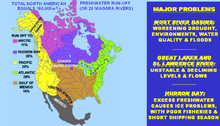
Water exports involve exporting freshwater from one country to another. Large increases in human population and economic growth throughout the world during the twentieth century placed a huge stress on the world’s freshwater resources. Combined with climate change, they are expected to place an even greater demand on water resources in this century. Water shortages have become an international concern, and freshwater has been described as “blue gold” and “the oil of the 21st Century.”

The Peripheral Canal was a series of proposals starting in the 1940s to divert water from California's Sacramento River, around the periphery of the San Joaquin-Sacramento River Delta, to uses farther south. The canal would have attempted to resolve a problem with the quality of water pumped south. Pumps create such a powerful suction that the boundary between freshwater to saltwater has shifted inland, negatively affecting the environment. The pumps have increased by 5 to 7 million acre-feet the amount of water exported each year to the Central Valley and Southern California. However, the peripheral canal as proposed would have reduced the overall freshwater flow into the Delta and move the freshwater-saltwater interface further inland, causing damage to Delta agriculture and ecosystems.

The Manych Ship Canal is a canal between the Black Sea lagoon the Sea of Azov and the Caspian Sea.

The phenomenon of paleoflooding is apparent in the geologic record over various spatial and temporal scales. It often occurred on a large scale, and was the result of either glacial ice melt causing large outbursts of freshwater, or high sea levels breaching bodies of freshwater. If a freshwater outflow event was large enough that the water reached the ocean system, it caused changes in salinity that potentially affected ocean circulation and global climate. Freshwater flows could also accumulate to form continental glacial lakes, and this is another indicator of large-scale flooding. In contrast, periods of high global sea level could cause marine water to breach natural dams and flow into bodies of freshwater. Changes in salinity of freshwater and marine bodies can be detected from the analysis of organisms that inhabited those bodies at a given time, as certain organisms are more suited to live in either fresh or saline conditions.

The Salt Water Barrier was a proposed project on the estuary of the Delaware River, which was projected in the late 1950s to convert the lower reaches of the Delaware into a freshwater lake. The barrier was proposed as a 30-foot (9.1 m) high dam near New Castle, Delaware, 53,300 feet (16,200 m) long, equipped with locks for the passage of shipping to Wilmington and Philadelphia. A study for the project was authorized by Congress in 1958, with engineering evaluations and public hearings by the U.S. Army Corps of Engineers. The prime purpose of the project was to develop the lower river as a source of drinking water for communities along the lower river. Objections to the barrier included concerns about the oyster industry, shipping constraints, increased shoaling, ice formation, and most importantly, the possibility of trapping pollutants above the barrier. The project was found to be technically feasible, but not economically practical. It was not included in the final Delaware River Basin Report of 1962, which proposed reservoirs higher in the Delaware River basin, and no further action was taken.

<span class="mw-page-title-main">Coastal reservoir</span> Place to store freshwater near seas

A Coastal reservoir is a type of reservoir to store fresh water on sea coast area near a river delta. Saemanguem in South Korea, Marina Barrage in Singapore, Qingcaosha and Plover Cove in China, Delta Works in Netherlands, and Thanneermukkom Bund in India are a few existing coastal reservoirs.

References

  1. Great Lakes water diversion CityMayors.com
  2. DeCew Falls II Archived 2008-07-05 at the Wayback Machine Ontario Power Generation
  3. A brief history of the Great Recycling and Northern Development (Grand) Canal project Undercurrents
  4. Dunbar, Max (1993, May) Centre for Climate and Global Change Research, McGill University
  5. The GRAND Canal Official Web Site: Proposal
  6. The GRAND Canal Official Website: Summary
  7. Bourassa, Robert (1985, May). Power From the North, Prentice Hall of Canada Ltd.
  8. 1 2 Milko, Robert (1986, December). Potential ecological effects of the proposed GRAND Canal diversion project on Hudson and James Bays. Arctic, 39(4): 316-325.
  9. Milko, Robert (1986, December). Potential ecological effects of the proposed GRAND Canal diversion project on Hudson and James Bays. Arctic, 39(4): 322.
  10. The planned destruction of Canada from the Social Credit Party of Canada newspaper the Michael Journal
  11. Usenet posting from 1996
  12. Amazon.com: Breakup: The Coming End of Canada and the Stakes for America: Lansing Lamont: Books
  13. The West By John Frederick Conway
  14. "Build your own conspiracy theory" Montreal Mirror