Groton (village), New York

Last updated

Groton, New York
USA New York location map.svg
Red pog.svg
Groton, New York
Location within the state of New York
Coordinates: 42°35′13″N76°21′54″W / 42.58694°N 76.36500°W / 42.58694; -76.36500
Country United States
State New York
County Tompkins
Settled1795 (1795)
IncorporatedJune 11, 1860 (1860-06-11)
Named for Uncertain, possibly named after Groton, Connecticut and Groton, Massachusetts, from where many early settlers hailed [1]
Government
  MayorChris Neville [2]
Area
[3]
  Total1.74 sq mi (4.50 km2)
  Land1.74 sq mi (4.50 km2)
  Water0.00 sq mi (0.00 km2)
Elevation
997 ft (304 m)
Population
 (2020)
  Total2,145
  Density1,234.89/sq mi (476.67/km2)
Time zone UTC-5 (Eastern (EST))
  Summer (DST) UTC-4 (EDT)
ZIP code
13073
Area code 607
FIPS code 36-30961
GNIS feature ID0951849
Website www.grotonny.org/village

Groton is a village in Tompkins County, New York, United States. The population was 2,363 at the 2010 census.

Contents

The Village of Groton is near the center of the Town of Groton and is northeast of Ithaca and west of Cortland.

History

The village lies within the former Central New York Military Tract and was first settled by outsiders around 1795. Before then, the only purpose of the land surrounding Groton was to host the winding trails of the Native Americans that once lived in central New York. Also, they used the Owasco Inlet as a water source for their people and possibly for transportation, though it is very shallow at some points. The village was within Cayuga County until Tompkins County was formed in 1817.

The Village of Groton was incorporated in 1860.

The village was served by the Southern Central Railroad and then later by the Lehigh Valley Railroad after the former was incorporated into the latter's system.

Groton Historical Association Museum Groton Historical Association Museum.jpeg
Groton Historical Association Museum

The Groton Historical Association Museum, at 172 Main Street, occupies a former Baptist meetinghouse.

The Groton High School was listed on the National Register of Historic Places in 1992. [4] Students now attend Groton Junior/Senior High School.

Geography

Groton is located at 42°35′12″N76°21′53″W / 42.58667°N 76.36472°W / 42.58667; -76.36472 (42.586922, -76.364908). [5]

According to the United States Census Bureau, the village has a total area of 1.7 square miles (4.5 km2). None of the area is covered with water.

New York State Route 38 intersects New York State Route 222 in the village.

Demographics

Historical population
CensusPop.Note
1870 863
1880 9237.0%
1890 1,28038.7%
1900 1,3445.0%
1910 1,260−6.2%
1920 2,23577.4%
1930 2,004−10.3%
1940 2,0874.1%
1950 2,1503.0%
1960 2,123−1.3%
1970 2,112−0.5%
1980 2,3139.5%
1990 2,3983.7%
2000 2,4703.0%
2010 2,363−4.3%
2020 2,145−9.2%
U.S. Decennial Census [6]

As of the census [7] of 2000, there were 2,470 people, 960 households, and 627 families residing in the village. The population density was 1,427.1 inhabitants per square mile (551.0/km2). There were 1,028 housing units at an average density of 593.9 per square mile (229.3/km2). The racial makeup of the village was 97.29% White, 0.57% Black or African American, 0.16% Native American, 0.08% Asian, 0.20% from other races, and 1.70% from two or more races. Hispanic or Latino of any race were 0.36% of the population.

There were 960 households, out of which 34.6% had children under the age of 18 living with them, 48.8% were married couples living together, 12.6% had a female householder with no husband present, and 34.6% were non-families. 28.6% of all households were made up of individuals, and 13.1% had someone living alone who was 65 years of age or older. The average household size was 2.46 and the average family size was 3.05.

In the village, the population was spread out, with 27.4% under the age of 18, 5.8% from 18 to 24, 28.1% from 25 to 44, 22.0% from 45 to 64, and 16.7% who were 65 years of age or older. The median age was 38 years. For every 100 females, there were 90.1 males. For every 100 females age 18 and over, there were 79.9 males.

The median income for a household in the village was $36,047, and the median income for a family was $43,563. Males had a median income of $31,250 versus $24,000 for females. The per capita income for the village was $18,108. About 3.5% of families and 5.2% of the population were below the poverty line, including 7.2% of those under age 18 and 3.3% of those age 65 or over.

Related Research Articles

<span class="mw-page-title-main">Genoa, New York</span> Town in New York, United States

Genoa is a town in Cayuga County, New York, United States. The population was 1,816 at the 2020 census. The town is named after Genoa in Italy.

<span class="mw-page-title-main">Locke, New York</span> Town in New York, United States

Locke is a town in Cayuga County, New York, United States. The population was 1,877 at the 2020 census. The town was named after John Locke, an English philosopher, and is the birthplace of Millard Fillmore, 13th President of the United States.

<span class="mw-page-title-main">Summerhill, New York</span> Town in New York, United States

Summerhill is a town in Cayuga County, New York, United States. The population was 1,217 at the 2010 census. The town name is that of a location in Ireland. Summerhill is in the southeastern corner of the county and is northeast of Ithaca.

Cortland West is a census-designated place and region in Cortland County, New York, United States. The population was 1,356 at the 2010 census.

<span class="mw-page-title-main">Harford, New York</span> Town in New York, United States

Harford is a town in Cortland County, New York, United States. The population was 943 at the 2010 census. Harford is in the southwestern corner of Cortland County and is south of Cortland.

Denmark is a town in Lewis County, New York, United States, named after the Kingdom of Denmark in northern Europe. The population was 2,860 at the 2010 census. The town is on the northwestern border of Lewis County and lies east of Watertown.

<span class="mw-page-title-main">Cayuta, New York</span> Town in New York, United States

Cayuta is a town in Schuyler County, New York, United States. As of the 2020 census, the population was 508.

Covert is a town in Seneca County, New York, United States. The population was 2,135 at the 2020 census.

Enfield is a town in Tompkins County, New York, United States. The population was 3,401 at the 2020 census.

<span class="mw-page-title-main">Forest Home, New York</span> CDP in New York, United States

Forest Home is a census-designated place (CDP) in Tompkins County, New York, United States. The population was 572 at the 2010 census.

Newfield is a census-designated place (CDP) in Tompkins County, New York, United States. The population was 759 at the 2010 census.

Northeast Ithaca is a census-designated place (CDP) in Ithaca (town), New York in Tompkins County, New York, United States. The population was 2,655 at the 2000 census.

<span class="mw-page-title-main">Trumansburg, New York</span> Village in New York, United States

Trumansburg is a village in Tompkins County, New York, United States. The population was 1,797 at the 2010 census. The name incorporates a misspelling of the surname of the founder, Abner Treman. The Tremans spelled their surname several different ways; "Truman," however, was not one of them. The village's application for a post office established the present spelling. The Village of Trumansburg is located within the Town of Ulysses and is northwest of Ithaca, New York.

The village of Moravia in Cayuga County, New York, United States is a community with population of about 1,200. The village of Moravia is in the southern part of the town of Moravia and is south of Auburn.

Van Etten is a town in Chemung County, New York, United States. It is part of the Elmira Metropolitan Statistical Area. The population of the town was 1,541 at the 2020 census. The town is named for the two brothers who founded the village of Van Etten in it. The town is at the northeastern corner of the county, northeast of Elmira.

<span class="mw-page-title-main">Dryden (village), New York</span> Village in New York, United States

Dryden is a village in Tompkins County, New York, United States. The population was 1,890 at the 2010 census. The name was assigned by a clerk, interested in the classics, to honor poet John Dryden. The village is in the town of Dryden, east of Ithaca. It is near the border of Cortland County.

<span class="mw-page-title-main">Groton (CDP), Massachusetts</span> Census-designated place in Massachusetts, United States

Groton is a census-designated place (CDP) comprising the main village in the town of Groton in Middlesex County, Massachusetts, United States. The population of the CDP was 1,353 at the 2020 census, out of 11,315 in the entire town of Groton.

<span class="mw-page-title-main">Dryden, New York</span> Town in New York, United States

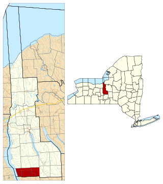
Dryden is a town in Tompkins County, New York, United States. The population was 14,435 at the 2010 census. The town administers an area that includes two villages, one also named Dryden and one named Freeville, as well as a number of hamlets. The town is on the county's eastern border, east of Ithaca, in the Finger Lakes region.

Groton is a town in Tompkins County, New York, United States. The population was 5,950 at the 2010 census. The name is taken from Groton, Massachusetts.

Lansing is a village in Tompkins County, New York, United States, and a suburb of Ithaca. The population was 3,648 at the 2020 census.

References

  1. "Important dates in the history of Groton, NY". Village of Groton. Archived from the original on September 15, 2013. Retrieved August 3, 2013. 1818 - Settlers in the hollow of Division petitioned to have the settlement's name changed to Groton. It Is suspected the reason this was because many of these early settlers were from both Groton Conn. and Groton, Mass.
  2. Village of Groton Board Members List of Village of Groton, NY Board Members, as of 01/17/2019.
  3. "ArcGIS REST Services Directory". United States Census Bureau. Retrieved September 20, 2022.
  4. "National Register Information System". National Register of Historic Places . National Park Service. March 13, 2009.
  5. "US Gazetteer files: 2010, 2000, and 1990". United States Census Bureau. February 12, 2011. Retrieved April 23, 2011.
  6. "Census of Population and Housing". Census.gov. Retrieved June 4, 2015.
  7. "U.S. Census website". United States Census Bureau . Retrieved January 31, 2008.