
A blizzard is a severe snowstorm characterized by strong sustained winds and low visibility, lasting for a prolonged period of time—typically at least three or four hours. A ground blizzard is a weather condition where snow that has already fallen is being blown by wind. Blizzards can have an immense size and usually stretch to hundreds or thousands of kilometres.

A nor'easter is a large-scale extratropical cyclone in the western North Atlantic Ocean. The name derives from the direction of the winds that blow from the northeast. Typically, such storms originate as a low-pressure area that forms within 100 miles (160 km) of the shore between North Carolina and Massachusetts. The precipitation pattern is similar to that of other extratropical storms, although nor'easters are usually accompanied by heavy rain or snow, and can cause severe coastal flooding, coastal erosion, hurricane-force winds, or blizzard conditions. They tend to develop most often and most powerfully between the months of November and March, because of the difference in temperature between the cold polar air mass coming down from central Canada and the warm ocean waters off the upper East Coast. The susceptible regions—the upper north Atlantic coast of the United States and the Atlantic Provinces of Canada—are generally impacted by nor'easters a few times each winter.

The 1993 Storm of the Century was a cyclonic storm, or nor'easter, that formed over the Gulf of Mexico on March 12, 1993. The cold weather, heavy snowfall, high winds and storm surges that the storm brought affected a very large area; at its height, it stretched from Canada to Honduras. The cyclone moved through the Gulf of Mexico and then through the eastern United States before moving on to eastern Canada. It eventually dissipated in the North Atlantic Ocean on March 15.
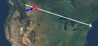
An Alberta clipper, also known as an Alberta low, Alberta cyclone, Alberta lee cyclone, Canadian clipper, or simply clipper, is a fast-moving low-pressure system that originates in or near the Canadian province of Alberta just east of the Rocky Mountains and tracks east-southeastward across southern Canada and the northern United States to the North Atlantic Ocean.

A panhandle hook is a relatively infrequent winter storm system whose cyclogenesis occurs in the South to southwestern United States from the late fall through winter and into the early spring months. They trek to the northeast on a path towards the Great Lakes region, as the southwesterly jet streams are most prevalent, usually affecting the Midwestern United States and Eastern Canada. Panhandle hooks account for some of the most memorable and deadly blizzards and snowstorms in North America. The name is derived from the region of surface cyclogenesis in the Texas panhandle and Oklahoma panhandle regions. In some winters, there are no panhandle hook storms; in others, there are several.
The 1991 Halloween blizzard was a powerful storm that caused a period of heavy snowfall and ice accumulation, which affected parts of the Upper Midwest of the United States, from October 31 to November 4, 1991. Over the last week of October 1991, a large storm system over the Atlantic Ocean blocked most of the weather patterns over the eastern half of the United States, and in turn, moisture from the Gulf of Mexico was funneled straight northward over the affected region. By the time the precipitation stopped falling, many cities in the eastern half of Minnesota and northwestern Wisconsin had witnessed record early-season snowfall accumulations, while parts of southern Minnesota and northern Iowa were crippled by a large ice storm. Arctic air that was pulled southward behind the storm had combined with the heavy snow pack to produce many record low temperatures. Between the blizzard and the ice storm, 22 people were killed and over 100 were injured.

The climate of the United States varies due to changes in latitude, and a range of geographic features, including mountains and deserts. Generally, on the mainland, the climate of the U.S. becomes warmer the farther south one travels, and drier the farther west, until one reaches the West Coast.

The January 2008 North American storm complex was a powerful Pacific extratropical cyclone that affected a large portion of North America, primarily stretching from western British Columbia to near the Tijuana, Mexico area, starting on January 3, 2008. The system was responsible for flooding rains across many areas in California along with very strong winds locally exceeding hurricane force strength as well as heavy mountain snows across the Cascade and Sierra Nevada mountain chains as well as those in Idaho, Utah and Colorado. The storms were responsible for the death of at least 12 people across three states, and extensive damage to utility services as well, as damage to some other structures. The storm was also responsible for most of the January 2008 tornado outbreak from January 7–8.

Hurricane Henri was a rare tropical cyclone that entered the Gulf of Mexico without having made landfall; it was the second of four times this occurred during the 20th century. The eighth named storm and fifth hurricane of the 1979 Atlantic hurricane season, it formed on September 14 in the northwestern Caribbean Sea. Throughout much of its duration, Henri moved erratically and initially maintained a general westward track. On September 16 it attained tropical storm status, and a day later it reached hurricane status. By two days later, after experiencing hostile conditions, Henri weakened to tropical depression status as it turned to the northeast, before degenerating into a remnant low on September 21. On September 24, it merged with a frontal low in the northeast Gulf of Mexico. Due to its slow and erratic motion, the hurricane forced evacuations along the Mexican coastline. Its remnants brought rainfall and flooding to the Florida Panhandle.

The December 1960 nor'easter was a significant early-season winter storm that impacted the Mid-Atlantic and New England regions of the United States. Moderate to heavy snowfall fell from West Virginia to eastern Maine, amounting to 10 in (25 cm) or more in parts of 13 states and peaking at 21.4 in (54 cm) at Newark, New Jersey. The storm was accompanied by strong winds, gusting to over 90 mph (140 km/h) in coastal New England, and left in its wake a dangerously cold air mass. The storm originated in a weak low pressure area which formed over the western Gulf of Mexico on December 10. A secondary low developed over South Carolina on the next day, supported by the merger of two troughs aloft. Sliding southeast of New England, the new storm explosively deepened to become a full-fledged nor'easter, with a minimum central air pressure of 966 mbar. It began to weaken over the Canadian Maritimes.

The March 2013 nor'easter was a powerful nor'easter that affected much of the United States, most notably New England. On March 6, the system moved into the Mid-Atlantic region of the east coast, and intensified into a nor'easter, dumping up to 3 feet of snow in some places. By late March 6, 2013, the nor'easter had knocked out power to about 250,000 homes and businesses.

The 2013–14 North American winter was one of the most significant for the United States, due in part to the breakdown of the polar vortex in November 2013, which allowed very cold air to travel down into the United States, leading to an extended period of very cold temperatures. The pattern continued mostly uninterrupted throughout the winter and numerous significant winter storms affected the Eastern United States, with the most notable one being a powerful winter storm that dumped ice and snow in the Southeastern United States and the Northeastern United States in mid-February. Most of the cold weather abated by the end of March, though a few winter storms did affect the Western United States towards the end of the winter.

The 2015–16 North American winter was not as frigid across North America and the United States as compared to the 2013–14 and 2014–15 winters. This was mainly due to a strong El Niño, which caused generally warmer-than-average conditions. However, despite the warmth, significant weather systems still occurred, including a snowstorm and flash flooding in Texas at the end of December and a large tornado outbreak at the end of February. The main event of the winter season, by far and large, was when a crippling and historic blizzard struck the Northeastern United States in late January, dumping up to 3 feet of snow in and around the metropolitan areas. Several other smaller snow events affected the Northeast as well, but for the most part the heaviest snowstorms and ice stayed out further west, such as a severe blizzard in western Texas in late December, and a major late-season snowstorm in Colorado in mid-April.

The January 2–4, 2014 North American blizzard was a major winter storm that affected much of the East Coast with snow, and frigid temperatures following the storm. The storm had dumped up to 2 ft (0.61 m) of snow in some areas, especially around Boston, Massachusetts.

The 2012–13 North American winter started out somewhat early, as the remnants of Hurricane Sandy brought heavy snow to the mountains of West Virginia in late October. Later, a strong nor'easter affected the weary Northeastern United States, hampering storm recovery efforts and dropping several inches of snow. The rest of the winter featured several other notable events, such as a Christmas winter storm that affected most of the Eastern United States, and the most notable event occurring in early February, when a powerful blizzard struck the Northeast and brought record snow to some areas. During the winter, a weak El Nino was expected to influence weather conditions across the continent.

The 2011–12 North American winter by and large saw above normal average temperatures across the continent, with the Contiguous United States encountering its fourth-warmest winter on record, along with an unusually low number of significant winter precipitation events. The primary outlier was Alaska, parts of which experienced their coldest January on record.

The 2010–11 North American winter was influenced by an ongoing La Niña, seeing winter storms and very cold temperatures affect a large portion of the Continental United States, even as far south as the Texas Panhandle. Notable events included a major blizzard that struck the Northeastern United States in late December with up to 2 feet (24 in) of snowfall and a significant tornado outbreak on New Year's Eve in the Southern United States. By far the most notable event was a historic blizzard that impacted areas from Oklahoma to Michigan in early February. The blizzard broke numerous snowfall records, and was one of the few winter storms to rank as a Category 5 on the Regional Snowfall Index. In addition, Oklahoma set a statewide low temperature record in February.

The 2017–18 North American winter saw weather patterns across North America that were very active, erratic, and protracted, especially near the end of the season, resulting in widespread snow and cold across the continent during the winter. Significant events included rare snowfall in the South, an outbreak of frigid temperatures that affected the United States during the final week of 2017 and early weeks of January, and a series of strong nor'easters that affected the Northeastern United States during the month of March. In addition, flooding also took place during the month of February in the Central United States. Finally the winter came to a conclusion with a powerful storm system that caused a tornado outbreak and blizzard in mid-April. The most intense event, however, was an extremely powerful cyclonic blizzard that impacted the Northeastern United States in the first week of 2018. Similar to the previous winter, a La Niña was expected to influence the winter weather across North America.

A black nor'easter is a persistent and potentially violent north-easterly storm that occurs on the east coast of Australia, particularly from southeastern Queensland to southern New South Wales, usually between late spring and early autumn, about two days a year.

The Miller classification is a technique that meteorologists use to classify nor'easters. The system splits nor'easters into five categories: Miller A, Miller B, Miller C, Miller D, and Miller E; the classification system initially started out with the first two categories. The system was derived by meteorologist and researcher J.E. Miller in 1946,.
