
Gwynedd is a county in the north-west of Wales. It borders Anglesey across the Menai Strait to the north, Conwy, Denbighshire, and Powys to the east, Ceredigion over the Dyfi estuary to the south, and the Irish Sea to the west. The city of Bangor is the largest settlement, and the administrative centre is Caernarfon. The preserved county of Gwynedd, which is used for ceremonial purposes, includes the Isle of Anglesey.
Conwy County Borough is a county borough in the north of Wales. It borders Gwynedd to the west and south and Denbighshire to the east. The largest settlement is Colwyn Bay, and Conwy is the administrative centre.

The preserved counties of Wales are the eight current areas used in Wales for the ceremonial purposes of lieutenancy and shrievalty. They are based on the counties which were used for local government and other purposes between 1974 and 1996. Each comprises one or more of the 22 single-tier principal areas which are used for administrative purposes.

Denbighshire is a county in the north-east of Wales. It borders the Irish Sea to the north, Flintshire to the east, Wrexham to the southeast, Powys to the south, and Gwynedd and Conwy to the west. Rhyl is the largest town, and Ruthin is the administrative centre. Its borders differ from the historic county of the same name.

Until 1974, Denbighshire, or the County of Denbigh, was an administrative county in the north of Wales, later classed as one of the thirteen historic counties of Wales. It was a maritime county, that was bounded to the north by the Irish Sea, to the east by Flintshire, Cheshire and Shropshire, to the south by Montgomeryshire and Merionethshire, and to the west by Caernarfonshire.
Clwyd is a preserved county of Wales, situated in the north-east corner of the country; it is named after the River Clwyd, which runs through the area. To the north lies the Irish Sea, with the English ceremonial counties of Cheshire to the east and Shropshire to the south-east. Powys and Gwynedd lie to the south and west respectively. Clwyd also shares a maritime boundary with Merseyside along the River Dee. Between 1974 and 1996, a slightly different area had a county council, with local government functions shared with six district councils. In 1996, Clwyd was abolished, and the new principal areas of Conwy County Borough, Denbighshire, Flintshire and Wrexham County Borough were created; under this reorganisation, "Clwyd" became a preserved county, with the name being retained for certain ceremonial functions.

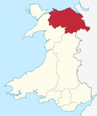
North Wales is a region of Wales, encompassing its northernmost areas. It borders mid Wales to the south, England to the east, and the Irish Sea to the north and west. The area is highly mountainous and rural, with Snowdonia National Park and the Clwydian Range and Dee Valley, known for its mountains, waterfalls and trails, wholly within the region. Its population is concentrated in the north-east and northern coastal areas, with significant Welsh-speaking populations in its western and rural areas. North Wales is imprecisely defined, lacking any exact definition or administrative structure. It is commonly defined administratively as its six most northern principal areas, but other definitions exist, with Montgomeryshire historically considered to be part of the region.

The Borough of Aberconwy was a local government district with borough status from 1974 to 1996, being one of five districts in the county of Gwynedd, north-west Wales.

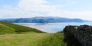
Rhos is a region to the east of the River Conwy in North Wales. It started as a minor kingdom then became a medieval cantref, and was usually part of the Kingdom of Gwynedd.
Llanrhos is a village in the community of Conwy, in Conwy County Borough, Wales. The village lies between the towns of Conwy and Llandudno. Llanrhos was a civil parish from 1894 until 1974. The area was formerly part of a larger parish called Eglwys Rhos or Eglwysrhos, being an old variant name for the same village. The ancient parish included Deganwy, the Craig-y-Don district of Llandudno, the Little Orme and Penrhyn Bay. The area was in the administrative county of Caernarfonshire prior to 1974.
Perfeddwlad or Y Berfeddwlad was an historic name for the territories in Wales lying between the River Conwy and the River Dee. comprising the cantrefi of Rhos, Rhufoniog, Dyffryn Clwyd and Tegeingl. Perfeddwlad thus was also known as the Four Cantrefs.
Llanbedr is a village in Gwynedd, northwest Wales.

Pentrefoelas is a village and community in Conwy County Borough, Wales. The village lies on the A5 road between Betws-y-Coed to the west and Cerrigydrudion to the east. The Afon Merddwr river, a tributary of the River Conwy, flows through it. The community had a population of 356 at the time of the 2011 census, 70% were able to speak Welsh. It has an area of 53.86 km2 and covers a large region around the village including part of Mynydd Hiraethog, Llyn Alwen and part of Alwen Reservoir. It is in the electoral ward of Llangernyw. The community includes the small settlement of Rhydlydan.

The 2015 United Kingdom general election in Wales was held on 7 May 2015 and all 40 seats in Wales were contested. The election for each seat was conducted on the basis of first-past-the-post.

North West Wales is an area or region of Wales, commonly defined as a grouping of the principal areas of Conwy County Borough, Gwynedd and the Isle of Anglesey in the north-west of the country. These principal areas make up the entire preserved county of Gwynedd, and parts of Clwyd. It is bordered by Denbighshire, in North East Wales to the east, Powys, and Ceredigion in Mid Wales to the south, and the Irish sea to the north and west. It is the more mountainous, rural, and sparsely populated part of the north Wales geographic region.
Llanfairfechan Town Football Club is a Welsh football team based in Llanfairfechan, Conwy County Borough, Wales. The team plays in the North Wales Coast East Premier Division.
The Register of Landscapes of Historic Interest in Wales is a non-statutory heritage register of 58 landscapes of outstanding or special historic interest published in two volumes. It was produced by a partnership between Cadw, the Countryside Council for Wales, and the International Council on Monuments and Sites working in collaboration with the Welsh Archaeological Trusts and several other organisations with the intention of aiding in the protection and conservation of the most important and significant historic landscape areas in Wales.