Hagerstown, Indiana

Last updated

Hagerstown, Indiana
Hagerstown, Indiana.jpg
Wayne County Indiana Incorporated and Unincorporated areas Hagerstown Highlighted 1830402.svg
Location of Hagerstown in Wayne County, Indiana
Coordinates: 39°54′41″N85°09′20″W / 39.91139°N 85.15556°W / 39.91139; -85.15556
Country Flag of the United States.svg United States
State Flag of Indiana.svg Indiana
County Wayne
Township Jefferson
Area
[1]
  Total1.32 sq mi (3.42 km2)
  Land1.32 sq mi (3.41 km2)
  Water0.00 sq mi (0.01 km2)
Elevation
[2]
981 ft (299 m)
Population
 (2020)
  Total1,681
  Density1,275.42/sq mi (492.35/km2)
Time zone UTC-5 (Eastern (EST))
  Summer (DST) UTC-4 (EDT)
ZIP code
47346
Area code 765
FIPS code 18-30402 [3]
GNIS feature ID2396981 [2]
Website http://www.hagerstown.in.gov/

Hagerstown is a town in Jefferson Township, Wayne County, in the U.S. state of Indiana. [2] As of the 2020 census, the population was 1,681.

Contents

Hagerstown from the air, looking northeast. Hagerstown-indiana-from-above.jpg
Hagerstown from the air, looking northeast.

History

Hagerstown was laid out and platted in 1832. [4] The town was named after the city of Hagerstown, Maryland. [5] The Hagerstown post office has been in operation since 1836. [6]

The Whitewater Canal, which was built in the mid-19th century and extends to Lawrenceburg, Indiana, has its northern terminus in Hagerstown. [7] This section was funded by the Hagerstown Canal Company.

The Hagerstown I.O.O.F. Hall and John and Caroline Stonebraker House are listed on the National Register of Historic Places. [8] [9]

Geography

The town lies 61 miles (98 kilometers) ENE of Indianapolis, Indiana, 17 miles (27 kilometers) NW of Richmond, Indiana, and 63 miles (101 kilometers) WNW of Dayton, Ohio in the Midwestern region of the United States.

Terrain surrounding Hagerstown consists of flat land at an elevation of roughly 1000 feet above sea level that is used primarily for agriculture.

According to the 2010 census, Hagerstown has a total area of 1.34 square miles (3.47 km2), all land. [10]

Demographics

The Hagerstown IOOF Hall is listed on the National Register of Historic Places Hagerstown I.O.O.F. Hall.jpg
The Hagerstown IOOF Hall is listed on the National Register of Historic Places
Historical population
CensusPop.Note
1850 606
1860 6385.3%
1870 83030.1%
1880 8927.5%
1890 873−2.1%
1900 862−1.3%
1910 9368.6%
1920 1,23832.3%
1930 1,2621.9%
1940 1,63829.8%
1950 1,6943.4%
1960 1,7302.1%
1970 2,05919.0%
1980 1,950−5.3%
1990 1,835−5.9%
2000 1,768−3.7%
2010 1,7871.1%
2020 1,681−5.9%
U.S. Decennial Census [11]

2010 census

As of the census [12] of 2010, there were 1,787 people, 751 households, and 467 families living in the town. The population density was 1,333.6 inhabitants per square mile (514.9/km2). There were 826 housing units at an average density of 616.4 per square mile (238.0/km2). The racial makeup of the town was 97.7% White, 0.6% African American, 0.2% Native American, 0.3% Asian, and 1.2% from two or more races. Hispanic or Latino of any race were 0.8% of the population.

There were 751 households, of which 31.4% had children under the age of 18 living with them, 47.1% were married couples living together, 10.7% had a female householder with no husband present, 4.4% had a male householder with no wife present, and 37.8% were non-families. 33.0% of all households were made up of individuals, and 16.5% had someone living alone who was 65 years of age or older. The average household size was 2.38 and the average family size was 3.02.

The median age in the town was 37.9 years. 25.6% of residents were under the age of 18; 8.3% were between the ages of 18 and 24; 25.1% were from 25 to 44; 23.1% were from 45 to 64; and 17.9% were 65 years of age or older. The gender makeup of the town was 48.4% male and 51.6% female.

2000 census

As of the census [3] of 2000, there were 1,768 people, 787 households, and 498 families living in the town. The population density was 1,276.0 inhabitants per square mile (492.7/km2). There were 832 housing units at an average density of 600.5 per square mile (231.9/km2). The racial makeup of the town was 99.26% White, 0.28% African American, 0.06% Native American, 0.11% Asian, 0.06% from other races, and 0.23% from two or more races. Hispanic or Latino of any race were 0.34% of the population.

There were 787 households, out of which 28.8% had children under the age of 18 living with them, 52.5% were married couples living together, 8.4% had a female householder with no husband present, and 36.6% were non-families. 34.6% of all households were made up of individuals living alone, and 16.6% had someone living alone who was 65 years of age or older. The average household size was 2.25 and the average family size was 2.86.

The population has 24.0% under the age of 18, 7.0% from 18 to 24, 28.1% from 25 to 44, 23.9% from 45 to 64, and 17.1% who were 65 years of age or older. The median age was 39 years. For every 100 females, there were 85.5 males. For every 100 females age 18 and over, there were 82.1 males.

The median income for a household in the town was $36,691, and the median income for a family was $48,864. Males had a median income of $35,536 versus $25,913 for females. The per capita income for the town was $20,901. About 0.8% of families and 1.8% of the population were below the poverty line, including none of those under age 18 and 0.9% of those age 65 or over.

Sites of interest

Education

Hagerstown Elementary and Hagerstown Jr./Sr. High School provide education for Hagerstown and smaller communities nearby. Hagerstown Jr./Sr. High School occupies a large campus which includes an outdoor laboratory and sporting facilities.

The town has a lending library, the Hagerstown-Jefferson Township Public Library. [13]

Notable people

Media

Radio

WBST (91.1 FM): Repeater for National Public Radio affiliated station owned by Ball State University.

Transportation

Hagerstown is situated on State Road 38, which passes through the town and intersects with State Road 1. Directly south of the town is Interstate 70, enabling travel and commuting to larger cities such as Indianapolis or Richmond.

By air, Hagerstown is served by the Hagerstown Airport. This is a public-use airport and utilizes a grass runway. The nearest commercial airport is Dayton International Airport in Dayton, Ohio.

The nearest rail link is the Amtrak station located in Connersville, Indiana.

Municipal partnerships

Related Research Articles

<span class="mw-page-title-main">Zanesville, Indiana</span> Town in Indiana, United States

Zanesville is a town in Wells and Allen counties in the U.S. state of Indiana, southwest of Fort Wayne. The population was 580 at the 2020 Census, down from 600 at the 2010 census.

<span class="mw-page-title-main">Jonesville, Indiana</span> Town in Indiana, United States

Jonesville is a town in Wayne Township, Bartholomew County, in the U.S. state of Indiana. The population was 177 at the 2010 census. It is part of the Columbus, Indiana metropolitan statistical area.

<span class="mw-page-title-main">Upland, Indiana</span> Town in Indiana, United States

Upland is a town in Jefferson Township, Grant County, Indiana, United States. The population was 3,821 at the 2020 census. It is the home of Taylor University, a Christian college.

<span class="mw-page-title-main">Springport, Indiana</span> Town in Indiana, United States

Springport is a town in Prairie Township, Henry County, Indiana, United States. The population was 149 at the 2010 census.

<span class="mw-page-title-main">Mount Etna, Indiana</span> Town in Indiana, United States

Mount Etna is a town in Huntington County, Indiana, United States. The population was 94 at the 2010 census. It lies at the intersection of four townships: Jefferson, Lancaster, Polk and Wayne.

<span class="mw-page-title-main">Winona Lake, Indiana</span> Town in Indiana, United States

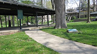
Winona Lake is a town in Wayne Township, Kosciusko County, in the U.S. state of Indiana, and the major suburb of Warsaw. The population was 4,908 at the 2010 census.

<span class="mw-page-title-main">Wolcottville, Indiana</span> Town in Indiana, United States

Wolcottville is a town in Orange Township, Noble County and Johnson Township, LaGrange County in the U.S. state of Indiana. The population was 998 at the 2010 census.

<span class="mw-page-title-main">Modoc, Indiana</span> Town in Indiana, United States

Modoc is a town in Union Township, Randolph County, in the U.S. state of Indiana. The population was 196 at the 2010 census.

<span class="mw-page-title-main">Dayton, Indiana</span> Town in Indiana, United States

Dayton is a town in Sheffield Township, Tippecanoe County, in the U.S. state of Indiana. The population was 1,420 at the 2010 census.

<span class="mw-page-title-main">Boston, Indiana</span> Town in Indiana, United States

Boston is a town in Boston Township, Wayne County, Indiana, United States. The population was 138 at the 2010 census.

<span class="mw-page-title-main">Cambridge City, Indiana</span> Town in Indiana, United States

Cambridge City is a town in Jackson Township, Wayne County, in the U.S. state of Indiana. The population was 1,870 at the 2010 census.

<span class="mw-page-title-main">Dublin, Indiana</span> Town in Indiana, United States

Dublin is a town in Jackson Township, Wayne County, in the U.S. state of Indiana. The population was 679 at the 2020 census.

<span class="mw-page-title-main">Economy, Indiana</span> Town in Indiana, United States

Economy is a town in Perry Township, Wayne County, in the U.S. state of Indiana. The population was 173 at the 2021 census.

<span class="mw-page-title-main">Fountain City, Indiana</span> Town in Indiana, United States

Fountain City, formerly Newport, is a town in New Garden Township, Wayne County, in the U.S. state of Indiana. The population was 796 at the 2010 census.

<span class="mw-page-title-main">Greens Fork, Indiana</span> Town in Indiana, United States

Greens Fork is a town in Clay Township, Wayne County, in the U.S. state of Indiana. The population was 423 at the 2010 census.

<span class="mw-page-title-main">Milton, Indiana</span> Town in Indiana, United States

Milton is a town in Washington Township, Wayne County, in the U.S. state of Indiana. The population was 490 at the 2010 census.

<span class="mw-page-title-main">Mount Auburn, Indiana</span> Town in Indiana, United States

Mount Auburn is a town in Jackson Township, Wayne County, in the U.S. state of Indiana. The population was 117 at the 2010 census. The town is sandwiched between Dublin and Cambridge City.

<span class="mw-page-title-main">Spring Grove, Indiana</span> Town in Indiana, United States

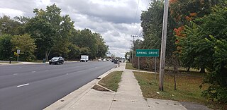
Spring Grove is a town in Wayne Township, Wayne County, in the U.S. state of Indiana. The population was 344 at the 2010 census.

<span class="mw-page-title-main">Whitewater, Indiana</span> Town in Indiana, United States

Whitewater is a town in Franklin Township, Wayne County, in the U.S. state of Indiana. The population was 83 at the 2010 census.

<span class="mw-page-title-main">Ossian, Indiana</span> Town in Indiana, United States

Ossian is a town in Jefferson Township, Wells County, in the U.S. state of Indiana. The town was named after Ossian, the narrator of a cycle of epic poems by the Scottish poet James Macpherson. The population was 3,289 at the 2010 census.

References

  1. "2020 U.S. Gazetteer Files". United States Census Bureau. Retrieved March 16, 2022.
  2. 1 2 3 U.S. Geological Survey Geographic Names Information System: Hagerstown, Indiana
  3. 1 2 "U.S. Census website". United States Census Bureau . Retrieved January 31, 2008.
  4. Young, Andrew White (1872). History of Wayne County, Indiana, from Its First Settlement to the Present Time. R. Clarke & Company. pp.  280.
  5. Dept. of English and Journalism (1970–1972). Indiana names, v.1-3. Indiana State University. p. 15.
  6. "Wayne County". Jim Forte Postal History. Retrieved July 7, 2016.
  7. History of Wayne County, Indiana: Together with Sketches of Its Cities, Villages and Towns, Volume 2. Inter-State Publishing Company. 1884. p. 616.
  8. "National Register Information System". National Register of Historic Places . National Park Service. July 9, 2010.
  9. "National Register of Historic Places Listings". Weekly List of Actions Taken on Properties: 12/15/14 through 12/19/14. National Park Service. December 24, 2014.
  10. "G001 - Geographic Identifiers - 2010 Census Summary File 1". United States Census Bureau. Archived from the original on February 13, 2020. Retrieved July 16, 2015.
  11. "Census of Population and Housing". Census.gov. Retrieved June 4, 2015.
  12. "U.S. Census website". United States Census Bureau . Retrieved December 11, 2012.
  13. "Indiana public library directory" (PDF). Indiana State Library. Archived from the original (PDF) on February 18, 2017. Retrieved March 15, 2018.
  14. Mike Bennett (August 11, 2014). "A Tale of Two Hagerstowns". Hagerstown, Indiana. Archived from the original on November 20, 2014. Retrieved May 19, 2017.