Hailstone
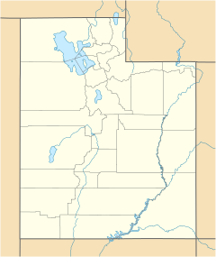
Location of the former town of Hailstone within the State of Utah
Hailstone was a town in northern Wasatch County, Utah, United States. [1]
Hailstone was a town in northern Wasatch County, Utah, United States. [1]
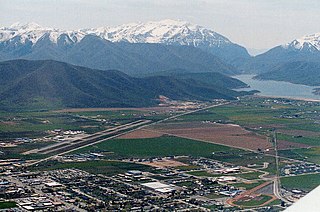
Hailstone was located at the junction on the former routing of US-40 and US-189, 7 miles (11 km) north of Heber City. [2] It was submerged in 1995 by the waters of Jordanelle Reservoir along with Jordanelle and Keetley.
Originally known as Elkhorn, Hailstone was homesteaded in 1864 by William Paret Hailstone, Ann Davis Hailstone, and others. The town was a base for mining, ranching, and logging. [3]

Wasatch County is a county in the U.S. state of Utah. As of the 2020 United States Census, the population was 34,788. Its county seat and largest city is Heber City. The county was named for a Ute word meaning "mountain pass" or "low place in the high mountains".

Fountain Green is a city in Sanpete County, Utah, United States. The population was 1,071 at the 2010 census.
Heber City is a city and county seat of Wasatch County, Utah. The population was 16,856 as of the 2020 United States census. The city is located 43 miles southeast of Salt Lake City.

U.S. Route 189 is a spur of U.S. Route 89. It currently runs for 322 miles (518 km) from Provo, Utah at Interstate 15 to Jackson, Wyoming. The highway was not part of the original 1926 U.S. Highway system. The highway was created in the 1930s, absorbing former U.S. Route 530 and a portion of U.S. Route 30S. The portion through Provo Canyon has been designated the Provo Canyon Scenic Byway by the state of Utah.

Jordanelle Reservoir is a reservoir in Wasatch County, Utah, United States, just north of Heber City.
Keetley is a ghost town located in northeastern Wasatch County, Utah, United States.

The Anna River is a 7.1-mile-long (11.4 km) river on the Upper Peninsula of the U.S. state of Michigan. The mouth of the river is at 46°24′40″N86°38′26″W in the city of Munising on the South Bay of Grand Island Harbor on Lake Superior.

The Salt Lake City Cemetery is a cemetery in northeastern Salt Lake City, Utah, United States, that is one of the largest city-operated cemeteries in the United States.

State Route 32 (SR-32) is a state highway in Wasatch and Summit Counties in the U.S. state of Utah. Most of the highway is an old routing of U.S. Route 189 that became disconnected from the rest of US-189 during the construction of the Jordanelle Reservoir. SR-32 runs for 29.053 miles (46.756 km) from US-40 and US-189 north of Heber City to I-80 near Wanship. Although signed US-189 or US-189 Alternate for most of its history, the highway pre-dates the creation of U.S. Highways and has had several numerical designations and route changes through the years.

Saunemin Township is located in Livingston County, Illinois, United States. As of the 2010 census, its population was 666 and it contained 281 housing units. It is named after, and contains, Saunemin, Illinois.
State Route 248 is a highway in northern Utah that connects Park City with Kamas. In Park City it is known as Kearns Boulevard.

Peoa is an unincorporated census-designated place in southwestern Summit County, Utah, United States, between Jordanelle and Rockport State Parks. It lies along State Route 32, south of the city of Coalville, the county seat of Summit County. Its elevation is 6,191 feet (1,887 m). The population was 253 at the 2010 census. Peoa is unincorporated with the ZIP code of 84061.

State Route 35 is a highway in northern Utah connecting SR-32 in Francis to SR-87 in Duchesne in a span of sixty-two miles.

Vivian Park is an unincorporated community in northeastern Utah County, Utah, United States.
Somersville is an unincorporated community in York Township, Union County, Ohio, United States. It is located at 40°24′00″N83°24′40″W, at the intersection of Ohio State Routes 31 and 47.


Davant is an unincorporated community located in the delta of the Mississippi River in the parish of Plaquemines, Louisiana, United States.
Bacchus is a ghost town in Salt Lake County, Utah, United States.
Jordanelle was a community in northern Wasatch County, Utah, United States.
![]() Media related to Hailstone, Utah at Wikimedia Commons
Media related to Hailstone, Utah at Wikimedia Commons
40°36′30″N111°24′40″W / 40.60833°N 111.41111°W
Municipalities and communities of Wasatch County, Utah, United States | ||
|---|---|---|
| Cities | 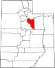 | |
| Towns | ||
| CDP | ||
| Unincorporated community | ||
| Indian reservation | ||
| Ghost towns | ||
| Footnotes | ‡This populated place also has portions in an adjacent county or counties | |
| | This article about a location in Utah is a stub. You can help Wikipedia by expanding it. |