
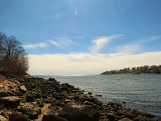
Madison is a town in the southeastern corner of New Haven County, Connecticut, United States, occupying a central location on Connecticut's Long Island Sound shoreline. The town is part of the South Central Connecticut Planning Region. The population was 17,691 at the 2020 census.

Guilford is an unincorporated community located in Howard County in the state of Maryland. The location is named after the Guilford Mill. Guilford is near Kings Contrivance, one of the nine "villages" of Columbia.

Chatfield Hollow State Park is a public recreation area occupying 412 acres (167 ha) that lie adjacent to Cockaponset State Forest in the town of Killingworth, Connecticut. The state park offers hiking trails, a swimming beach, trout fishing, mountain biking, rock climbing, and picnicking areas. Park attractions include 6.67-acre (2.70 ha) Schreeder Pond, Indian caves, historic sites, a restored water wheel, and a reproduction covered bridge. The park is managed by the Connecticut Department of Energy and Environmental Protection.
Rocky Neck State Park is a public recreation area on Long Island Sound in the town of East Lyme, Connecticut, United States. The state park's 708 acres (287 ha) include a tidal river, a broad salt marsh, white sand beaches, rocky shores, and a large stone pavilion dating from the 1930s. It is managed by the Connecticut Department of Energy and Environmental Protection.
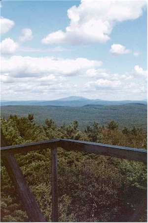
Mount Grace, 1,617 feet (493 m), is a prominent monadnock located in north central Massachusetts in the town of Warwick, approximately two miles south of the New Hampshire border. The mountain is rugged and largely wooded, but a firetower on the summit provides expansive views of the surrounding rural countryside. Little Mount Grace, 1,226 feet (374 m), is the southern summit of the mountain. Mount Grace supports a predominantly northern hardwood forest as well as stands of red spruce near its summit.

The Hammonasset River is formed about 4 miles (6.4 km) southeast of Durham, Connecticut along a gully on the north end of Bunker Hill at about a half mile northeast of the junction of Route 148 and Bunker Hill Road. The river travels for 21.0 miles (33.8 km) to Clinton Harbor on Long Island Sound just east of Hammonasset Beach State Park. A popular paddling route runs for about 10 miles (16 km) starting along Summer Hill Road about 2.5 miles (4.0 km) south on Route 79 from North Madison, Connecticut. This is a scenic river run with mostly flat and quickwater, but with a few Class I-II whitewater areas.

Historic RittenhouseTown, sometimes referred to as Rittenhouse Historic District, encompasses the remains of an early industrial community which was the site of the first paper mill in British North America. The mill was built in 1690 by William Rittenhouse and his son Nicholas on the north bank of Paper Mill Run near Philadelphia, Pennsylvania. The district, off Lincoln Drive near Wissahickon Avenue in Fairmount Park, includes six of up to forty-five original buildings. RittenhouseTown was listed on the National Register of Historic Places and was designated a National Historic Landmark District on April 27, 1992.

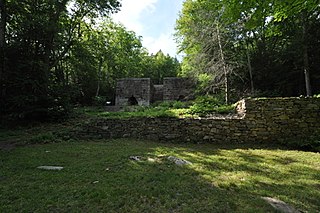
The Gurleyville Historic District encompasses a formerly industrial rural crossroads village in Mansfield, Connecticut. Centered on Gurleyville and Chaffeeville Roads, it includes a collection of mainly vernacular 19th-century residences, a stone gristmill dating to about 1749, and the archaeological remains of later industrial endeavours. The district was listed on the National Register of Historic Places in 1975.

Warren Hull House is a historic home located at Lancaster in Erie County, New York. It was built about 1810 by Warren Hull, one of Erie County's earliest pioneers. It is in the Federal style and includes the family burial plot in the rear of the property. It is the oldest stone house in western New York and is currently owned by the Hull Family home association.
Hammonasset may refer to the following in the U.S. state of Connecticut:

Hallville Mill Historic District is a historic district in the town of Preston, Connecticut, that was listed on the National Register of Historic Places in 1996. Contributing properties in the district are 23 buildings, two other contributing structures, and one other contributing site over a 50-acre (20 ha) area. The district includes the dam that forms Hallville Pond, historic manufacturing buildings and worker housing, and the Hallville Mill Bridge, a lenticular pony truss bridge built circa 1890 by the Berlin Iron Bridge Company.

Bridge No. 1132 is an open-spandrel concrete arch bridge carrying the two-lane Connecticut Route 80 across the Hammonasset River, between Killingworth and Madison, Connecticut. Built in 1934, it is one of a small number of open-spandrel concrete bridges in the state, and was noted for its aesthetics at the time of its construction. It was listed on the National Register of Historic Places in 2004.

Clinton is a town in Middlesex County, Connecticut, United States. The town is part of the Lower Connecticut River Valley Planning Region. The population of the town was 13,185 at the 2020 census. The town center along the shore line was listed as a census-designated place (CDP) by the U.S. Census Bureau in the 2020 census.
The Wiswall Falls Mill Site is a historic archaeological industrial site in Durham, New Hampshire. It is located in John Hatch Park, a small public park just south of Wiswall Road on the eastern bank of the Lamprey River. The 3-acre (1.2 ha) site encompasses the remains of a small 19th-century mill complex that was one of Durham's major industrial sites of the 19th century until it burned in 1883. The site, which includes remains of the waterworks and foundations, was listed on the National Register of Historic Places in 1988.

Upton State Forest is a publicly owned forest with recreational features primarily located in the town of Upton, Massachusetts, with smaller sections in the towns of Hopkinton and Westborough. The state forest encompasses nearly 2,800 acres (1,100 ha) of publicly accessible lands and includes the last remaining Civilian Conservation Corps (CCC) camp in Massachusetts, built in Rustic style. The CCC campground was listed on the National Register of Historic Places in 2014.
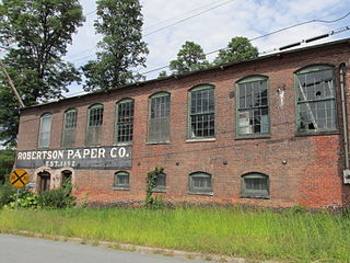
The Robertson Paper Company Complex was a historic industrial facility on Island Street in Bellows Falls, Vermont. It consisted of a collection of mostly-interconnected factory and related buildings, built between c. 1890 and c. 1960 by various paper-related companies. It was occupied and enlarged by the Robertson Paper Company between 1907 and its failure in 1987, at which time it was the longest-lived paper company in the state. The complex was listed on the National Register of Historic Places in 1990. It was demolished in 2018-19 as a Brownfields Economic Revitalization Alliance (BERA) project, with federal, state, and local funding.

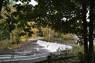
The Green River Crib Dam is a historic 19th-century dam on the Green River in western Guilford, Vermont. Built about 1811, it is a reminder of the modest industrial enterprises once conducted in the area using the water power it provided, and is one of the state's few surviving crib dams. It was listed on the National Register of Historic Places in 1995.

The Barkhamsted Lighthouse was a historical community located in what is now Peoples State Forest in Barkhamsted, Connecticut. Set on a terrace above the eastern bank of the West Branch Farmington River, it was in the 18th and 19th centuries a small village of economically marginalized mixed Native American, African American, and white residents. It was given the name "lighthouse" because its lights acted as a beacon marking the north–south stage road that paralleled the river. The archaeological remains of the village site were listed on the National Register of Historic Places in 1991 as Lighthouse Archeological Site (5-37).
Mine Hills Preserve is a natural and historical conservation area on Mine Hills Road in northwestern Roxbury, Connecticut. Owned by the Roxbury Land Trust, it protects the site of a well-preserved 19th-century iron mine and furnace works. Several miles of trails provide access to abandoned quarry areas and the preserved remains of the iron works, whose uses are explained by informational panels. The preserve is open from dawn to dusk. The 360-acre (150 ha) preserve was listed on the National Register of Historic Places in 1979.

The State Park Supply Yard is a historic maintenance facility at 51 Mill Road in Madison, Connecticut. The facility buildings were built in 1933-35 by crews of the Civilian Conservation Corps, and remain a well-preserved example of the Corps' work. Still used by the state, the facility was listed on the National Register of Historic Places in 1986.


