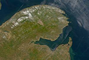
Chaleur Bay, also Chaleurs Bay, baie of Chaleur, is an arm of the Gulf of Saint Lawrence located between Quebec and New Brunswick, Canada.
Baie-Mahault is a commune in the overseas department and region of Guadeloupe, France. It is the second most populated commune of Guadeloupe, after Les Abymes. The extensive industrial zone of Jarry in Baie-Mahault is by far the most industrialized commune in the islands and the largest industrial park in the Lesser Antilles. It is part of the urban area of Pointe-à-Pitre, the largest metropolitan area in Guadeloupe, located in the northwest.
Baie-Comeau is a city located approximately 420 km (260 mi) north-east of Quebec City in the Côte-Nord region of the province of Quebec, Canada. It is located on the shores of the Saint Lawrence River near the mouth of the Manicouagan River, and is the seat of Manicouagan Regional County Municipality.

La Baie is one of three boroughs in the city of Saguenay, Quebec, Canada. It was created during Quebec's municipal reorganization in 2002. From 1976 to 2001, it was known as the Town of La Baie, a municipality composed of the Grande-Baie, Bagotville and Port-Alfred sectors.

Jamésie is a territory equivalent to a regional county municipality (TE) of Nord-du-Québec, Canada.

Fatu-Hiva is the southernmost island of the Marquesas Islands in French Polynesia, an overseas territory of France in the Pacific Ocean. With Motu Nao as its closest neighbor, it is also the most isolated of the inhabited islands.

Gros-Mécatina is a municipality on the Lower North Shore of the Gulf of Saint Lawrence, near the border with Labrador in Quebec, Canada. Located near crab, lobster, and scallop fishing grounds, it is dependent on the fishing business, including a fish processing factory that contributes to regional economic activity.

Blanc-Sablon is the easternmost community in Le Golfe-du-Saint-Laurent Regional County Municipality, in the administrative région of Côte-Nord, in the province of Quebec, Canada. With a population of 1,122 inhabitants in 2021, it is the most populous community in the county municipality.
Fortune Bay is a fairly large natural bay located in the Gulf of St. Lawrence on the south coast of Newfoundland, Canada. The Bay is bounded by Point Crewe on the Burin Peninsula and Pass Island at the entrance to Hermitage Bay to the northwest for a distance of 56 kilometers. The bay extends in a northeast direction for 105 kilometers ending at Terrenceville.

Le Crotoy is a commune in the Somme department in Hauts-de-France in northern France. The inhabitants are known as Crotellois.
Bay d'Espoir is an arm of Hermitage Bay in the Gulf of Saint Lawrence, located on the south coast of Newfoundland. Communities in Bay d'Espoir include: Milltown-Head of Bay d'Espoir, Morrisville, St. Alban's, St. Joseph's Cove, St. Veronica's and Miawpukek. The Miawpukek First Nation reserve of Samiajij Miawpukek is located in Bay d'Espoir.

Baie-Sainte-Catherine, Quebec is a town in Quebec, Canada. The municipal's territory extends along the Saguenay and Saint Lawrence rivers, whereas the town itself is on the small St. Catherine Bay, which is located at the confluence of these two rivers. Its elevation is 260 feet.

Saint-Stanislas-de-Kostka is a municipality of Quebec, Canada, located within the Beauharnois-Salaberry Regional County Municipality in the Montérégie administrative region. The population as of the Canada 2021 Census was 1,852.
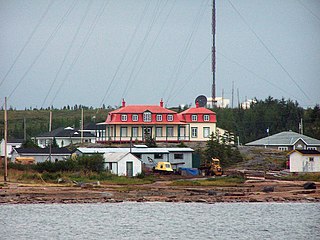
Baie-Johan-Beetz is a municipality and village in the Côte-Nord region of the province of Quebec in Canada, located some 60 kilometres (37 mi) east of Havre-Saint-Pierre. It has the lowest population of all incorporated places in the Côte-Nord region.
Les Îlets-Jérémie is a settlement in the municipality of Colombier in the Côte-Nord region of the Canadian province of Quebec. Located on the north shore of the Saint Lawrence River, the small community is named after the Jérémie Islets that are just off its shores and mark the western end of the Jérémie Islets Bay. The Innu call the hamlet Ishkuamishkut, meaning "where one expects polar bear".

Baie des Trépassés, or the Bay of the Dead, is a bay on Cap Sizun on the west coast of Finistère, in Brittany, France. The bay is located between Pointe du Raz and Pointe du Van, on the territory of the commune of Plogoff.

Français Glacier is a glacier 4 nautical miles (7 km) wide and 12 nautical miles (22 km) long, flowing north-northeast from the continental ice to the Antarctic coast close west of Ravin Bay. Though no glaciers were noted on Captain Jules Dumont d'Urville's chart of this coast, the close correlation of his "Baie des Ravins" feature and narrative description with the indentation of the coast near the mouth of this glacier suggests first sighting of this feature by the French Antarctic Expedition, 1837–40. During December 1912 members of the Main Base Party of the Australasian Antarctic Expedition (AAE) camped on the upland slopes close east of the glacier, but no reference was made to the glacier in the AAE reports, though a clear view and unpublished sketch were obtained of the distant coast to the northwest.
The Véronique River is a river in the Côte-Nord region of the province of Quebec, Canada. It flows into the Gulf of Saint Lawrence, opposite to Anticosti Island.

The Piashti River is a salmon river in the Côte-Nord region of the province of Quebec, Canada. It empties into the Gulf of Saint Lawrence.
The Baie des Rochers River is a tributary of the northwest shore of the St. Lawrence River, flowing into the town of Saint-Siméon, in the Charlevoix-Est Regional County Municipality, in the Capitale-Nationale administrative region, Quebec, Canada. The course of this river goes through the village of Baie-des-Rochers before going to the Bay of Rochers, in the St. Lawrence River.

