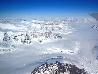
A glacier is a persistent body of dense ice that is constantly moving under its own weight. A glacier forms where the accumulation of snow exceeds its ablation over many years, often centuries. Glaciers slowly deform and flow under stresses induced by their weight, creating crevasses, seracs, and other distinguishing features. They also abrade rock and debris from their substrate to create landforms such as cirques, moraines, or fjords. Glaciers form only on land and are distinct from the much thinner sea ice and lake ice that forms on the surface of bodies of water.

A valley is an elongated low area often running between hills or mountains, which will typically contain a river or stream running from one end to the other. Most valleys are formed by erosion of the land surface by rivers or streams over a very long period of time. Some valleys are formed through erosion by glacial ice. These glaciers may remain present in valleys in high mountain or polar areas. At lower latitudes and altitudes, these glacially formed valleys may have been created or enlarged during ice ages but now are ice-free and occupied by streams or rivers. In desert areas, valleys may be entirely dry or carry a watercourse only rarely. In areas of limestone bedrock, dry valleys may also result from drainage taking place underground rather than at the surface. Rift valleys arise principally from earth movements, rather than erosion. Many different types of valley are described by geographers, using terms that may be global in use or else applied only locally.

Watkins Glen State Park is in the village of Watkins Glen, south of Seneca Lake in Schuyler County in New York's Finger Lakes region. The park's lower part is near the village, while the upper part is open woodland. It was opened to the public in 1863 and was privately run as a tourist resort until 1906, when it was purchased by New York State. Initially known as Watkins Glen State Reservation, the park was first managed by the American Scenic and Historic Preservation Society before being turned over to full state control in 1911. Since 1924, it has been managed by the Finger Lakes Region of the New York State Office of Parks, Recreation and Historic Preservation.

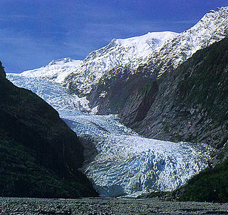
The Franz Josef Glacier / Kā Roimata o Hine Hukatere is a 12-kilometre-long (7.5 mi) temperate maritime glacier in Westland Tai Poutini National Park on the West Coast of New Zealand's South Island. Together with the Fox Glacier 20 kilometres (12 mi) to the south, and a third glacier, it descends from the Southern Alps to less than 300 metres (980 ft) above sea level.
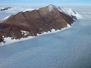
The Pensacola Mountains are a large group of mountain ranges of the Transantarctic Mountains System, located in the Queen Elizabeth Land region of Antarctica.
The Britannia Range is an Antarctic mountain range bounded by the Hatherton and Darwin glaciers on the north and the Byrd Glacier on the south, westward of the Ross Ice Shelf. Discovered by the British National Antarctic Expedition (1901–04) under Scott.
The Darwin Mountains is a group of mountains between the Darwin and Hatherton glaciers in Antarctica. Discovered by the British National Antarctic Expedition (1901–04) and named for Major Leonard Darwin, at that time Honorary Secretary of the Royal Geographical Society.

An icefall is a portion of certain glaciers characterized by relatively rapid flow and chaotic crevassed surface, caused in part by gravity. The term icefall is formed by analogy with the word waterfall, which is a similar phenomenon of the liquid phase but at a more spectacular speed. When ice movement of a glacier is faster than elsewhere, because the glacier bed steepens or narrows, and the flow cannot be accommodated by plastic deformation, the ice fractures, forming crevasses. Where two fractures meet, seracs can be formed. When the movement of the ice slows down, the crevasses can coalesce, resulting in the surface of the glacier becoming smoother.

Glacial landforms are landforms created by the action of glaciers. Most of today's glacial landforms were created by the movement of large ice sheets during the Quaternary glaciations. Some areas, like Fennoscandia and the southern Andes, have extensive occurrences of glacial landforms; other areas, such as the Sahara, display rare and very old fossil glacial landforms.

The Khumbu Icefall is located at the head of the Khumbu Glacier and the foot of the Western Cwm, which lies at an altitude of 5,486 metres (17,999 ft) on the Nepali slopes of Mount Everest, not far above Base Camp and southwest of the summit. The icefall is considered one of the most dangerous stages of the South Col route to Everest's summit.

A serac is a block or column of glacial ice, often formed by intersecting crevasses on a glacier. Commonly house-sized or larger, they are dangerous to mountaineers, since they may topple with little warning. Even when stabilized by persistent cold weather, they can be an impediment to glacier travel.
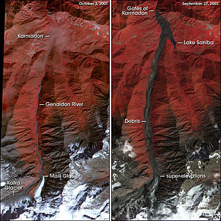
The Kolka–Karmadon rock-ice slide occurred on the northern slope of the Mount Kazbek massif in North Ossetia–Alania on 20 September 2002, following a partial collapse of the Kolka Glacier. It started on the north-northeast wall of Dzhimarai-Khokh, 4,780 m (15,680 ft) above sea level, and seriously affected the valley of Genaldon and Karmadon. The resulting avalanche and mudflow killed more than 120 people While this type of avalanche is not uncommon this particular event is considered extraordinary because of several aspects.

U-shaped valleys, also called trough valleys or glacial troughs, are formed by the process of glaciation. They are characteristic of mountain glaciation in particular. They have a characteristic U shape in cross-section, with steep, straight sides and a flat or rounded bottom. Glaciated valleys are formed when a glacier travels across and down a slope, carving the valley by the action of scouring. When the ice recedes or thaws, the valley remains, often littered with small boulders that were transported within the ice, called glacial till or glacial erratic.
Glacier morphology, or the form a glacier takes, is influenced by temperature, precipitation, topography, and other factors. The goal of glacial morphology is to gain a better understanding of glaciated landscapes and the way they are shaped. Types of glaciers can range from massive ice sheets, such as the Greenland ice sheet, to small cirque glaciers found perched on mountain tops. Glaciers can be grouped into two main categories:
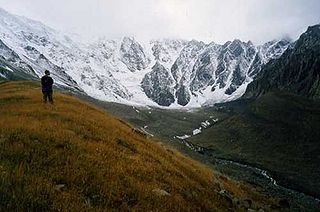
Kolka Glacier is a glacier in North Ossetia, Russia, near Mount Kazbek, known for its surging properties. The most recent and the most powerful surge took place on 20 September 2002, resulting in the death of ca. 140 people.
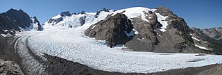
Blue Glacier is a large glacier located to the north of Mount Olympus in the Olympic Mountains of Washington. The glacier covers an area of 1.7 sq mi (4.4 km2) and contains 580,000,000 cu ft (16,000,000 m3) of ice and snow in spite of its low terminus elevation. The glacier length has decreased from about 3.4 mi (5.5 km) in 1800 to 2.7 mi (4.3 km) in the year 2000. Just in the period from 1995 and 2006, Blue Glacier retreated 325 ft (99 m). Blue Glacier is also thinning as it retreats and between 1987 and 2009 the glacier lost 178 ft (54 m) of its depth near its terminus and between 32 and 48 ft in the uppermost sections of the glacier known as the accumulation zone.

Wright Upper Glacier is an ice apron at the upper west end of Wright Valley in Asgard Range, Antarctica. It is formed by a glacier flowing east from the inland ice plateau. Named by the Victoria University of Wellington Antarctic Expedition (VUWAE) (1958–59) for C.S. Wright, a member of the British Antarctic Expedition (1910–13), after whom the "Wright Glacier" was named.
Ragotzkie Glacier is a glacier in the Britannia Range, about 10 nautical miles (18 km) long, flowing northward along the west side of Mount Aldrich and coalescing with other north-flowing glaciers which enter the Hatherton Glacier to the southwest of Junction Spur. Named by Advisory Committee on Antarctic Names (US-ACAN) for Robert A. Ragotzkie, project director for United States Antarctic Research Program (USARP) studies of lakes in the ice-free valleys. He made personal studies in Victoria Land in the 1962–63 season.

Karmadon (Genaldon) gorge is a gorge in North Ossetia. The Genaldon river of the Greater Caucasus mountain system flows in the gorge. In the upper reaches of the gorge there are two glaciers: Kolka and Mayli. It is located at altitudes from 750 m to 1200 m above sea level.


