Hartford, Tennessee

Last updated

Hartford, Tennessee
Hartford-from-I40-tn.jpg
Businesses in Hartford
USA Tennessee location map.svg
Red pog.svg
Hartford
Location within the state of Tennessee
Usa edcp location map.svg
Red pog.svg
Hartford
Hartford (the United States)
Coordinates: 35°49′0″N83°8′36″W / 35.81667°N 83.14333°W / 35.81667; -83.14333
Country United States
State Tennessee
County Cocke
Elevation
[1]
1,263 ft (385 m)
Population
 (2000)
  Total814
Time zone UTC-5 (Eastern (EST))
  Summer (DST) UTC-4 (EDT)
ZIP codes
37753
GNIS feature ID1328398 [1]

Hartford is an unincorporated community in Cocke County, Tennessee, located in the southeastern United States. Although it is not a census-designated place, the ZIP Code Tabulation Area for the ZIP Code (37753) that serves Hartford had a population of 814, according to the 2000 census. [2]

Contents

Hartford is the easternmost community in Tennessee along Interstate 40, and thus acts as the state's "gateway" by helping to maintain the Tennessee Welcome Center. The community is located at the northeastern tip of the Great Smoky Mountains and lies within the Cherokee National Forest.

Demographics

As of the census [3] of 2000, there were 814 people, 333 households, and 226 families residing in the Zip Code Tabulation Area for zip code 37753, which serves Hartford. The racial makeup of the ZCTA was 98.2% White, 0.1% Native American, 0.1% Asian, and 1.6% from two or more races. Hispanic and Latino of any race were 1.4% of the population.

There were 333 households, out of which 27.0% had children under the age of 18 living with them, 48.3% were married couples living together, 13.8% had a female householder with no husband present, and 32.1% were non-families. The average household size was 2.44 and the average family size was 2.94.

78.9% of the population was 18 years of age or older with 13.6% being 65 years of age or older. The median age was 39.9 years. The population was 53.1% male and 46.9% female.

The median income for a household in ZCTA 37753 was $20,357, and the median income for a family was $25,185. The per capita income for the ZCTA was $10,684. About 23.0% of families and 29.8% of the population were below the poverty line.

Geography

Eastern Cocke County, looking north from the summit of Mt. Cammerer View-from-cammerer.jpg
Eastern Cocke County, looking north from the summit of Mt. Cammerer

Hartford is located at 35°49′0″N83°8′36″W / 35.81667°N 83.14333°W / 35.81667; -83.14333 (35.816670, -83.143330). [4] The community is situated in a narrow valley along the Pigeon River, which flows from its source high in the Blue Ridge Mountains down into the flatlands of Cocke County. The river's valley divides the Great Smokies crest to the southwest from the Snowbird massif to the northeast.

Hartford is surrounded by mountains on all sides, with Snowbird Mountain rising some 4,200 feet to the east and Mount Cammerer— the easternmost of the Great Smokies— rising nearly 5,000 feet to the south. To the west, Foothills Parkway traverses Green Mountain, connecting the Pigeon Valley to Cosby, Tennessee. Stone Mountain, commonly called Hall Top, dominates the area to the north.

Interstate 40, which passes through Hartford, follows the Pigeon River Valley between Cocke County and Haywood County, North Carolina. Along I-40, Hartford is located roughly halfway between Knoxville, Tennessee and Asheville, North Carolina.

History

Pigeon Valley Church, organized in 1889 Pigeon-valley-church.jpg
Pigeon Valley Church, organized in 1889

The first known permanent settler in what is now Hartford was Solomon Williams, who arrived in the area in 1853. He was followed shortly thereafter by Moses Clark, who would donate the land upon which a log meeting house was built. For much of the 19th century, this meeting house was used for various functions, including church services and school. In this period, the community was known simply as Pigeon Valley. Hartford's Pigeon Valley Church, organized in 1889, still bears the town's old name. [5]

Like many Appalachian communities, Pigeon Valley thrived during the logging boom of the late 19th century. Innovations such as the band saw and high demand for wood led lumber companies to seek out the dense forests of the Appalachian Mountains for timber. The Scottish-Carolina Timber and Land Company, which had established a foothold in the region through its American agent Alexander Arthur (1846–1912), was among the first to harvest the trees in the Pigeon Valley area, which they moved downstream via river current to the A.C. Lawrence Leather Company factory in Newport. The leather company used the trees' bark in the tanning process. [5] The Scottish Lumber venture lasted for roughly six years. In 1886, a massive flood on the Pigeon River scattered the company's stock of logs, and the company was forced to shut down operations. [6]

Early 1900s

Pigeon Valley was given the name "Hartford" in honor of John Hart, co-owner of the Tennessee & North Carolina Railroad who supervised the construction of a line through the valley connecting Newport and Waterville.

In 1917, the Boice Hardwood Company erected a band mill at Hartford with plans to log the river's north bank all the way to Max Patch Mountain. Hartford quickly developed into a company town, situated around the band mill. [7] Mary Bell Smith, who lived in Hartford during this period, recalls:

Every morning Hartford came to life at five o'clock with the shrill whistle from the sawmill that signaled the new day. Before dawn, the big steam boiler began belching out the steam which operated the sawmill for another day. The bandsaw hummed, the cut-off saw screeched, and the drag-chain rumbled as it carried trash, cull lumber, and sawdust up the conveyor to the blazing furnace. [8]

As the mill prospered in the 1920s Hartford grew to include several frame houses, a general store, a post office, a school, and a movie theater. The sawmill's generators even provided electricity to the town from 5am to 10pm. [9] Converts trickled into the old Pigeon Valley Church. Smith recalled a baptism held in Hartford in the dead of winter in 1925:

At two o'clock that Sunday afternoon, Rev. Hall walked into the Pigeon River, pushing away mushy ice as he walked. Wading far enough out into the river for the water to reach about waist high, he prepared himself for the baptismal service. We spectators watched with steamy breath from the river banks as the newly converted believers were momentarily buried in the icy waters. [10]

With the onset of the Great Depression in the early 1930s, the timber market dried up, and Boice Hardwood was forced to close. [11] Hartford wouldn't recover economically until the construction of I-40 through the town in the 1960s. [12]

The Pigeon River Pollution Controversy

Pigeon River in Hartford Hartford-Pigeon-River-tn2.jpg
Pigeon River in Hartford

While the various lumber industries along the Pigeon River brought at least temporary prosperity to many of the valley's communities, the long-term effects of the mills' use of the river for waste dumping eventually began to take its toll.

In 1908, Champion International (then known as the Champion Fibre Company)— which had bought up large tracts of forest in the Smokies— established a paper mill in Canton, North Carolina (upstream from Hartford). Over the next few decades, Champion, like other industries along the Pigeon, used the river to dispose of its industrial waste.

Throughout the 20th century, the Pigeon River Valley experienced a relatively high rate of cancer and other toxin-related deaths. Hartford itself was hit particularly hard, earning the nickname "Widowville." [13] Environmentalists blamed the high cancer rate on the unusually high levels of dioxins and dioxin-like compounds in the tissue of fish living in the river. After it was determined that Champion's Canton mill was the primary source of the excessive dioxin levels, the Environmental Protection Agency began to pressure the paper manufacturer to reduce its dioxin emissions. The debate reached a high point in 1988, when then-Senator Al Gore— who was seeking the Democratic presidential nomination— intervened on behalf of Champion. As Gore is normally pro-environment, many saw this move as hypocritical, and accused Gore of selling out the Pigeon Valley in order to gain much-needed primary votes in North Carolina. [14]

In spite of Gore's apparent snub, pressure from environmental groups continued, and Champion began taking measures to drastically reduce dioxin emissions in the early 1990s. By 1994, Champion had spent $330 million modernizing its plant before new regulations forced the company to sell the plant in 1999. [14] Starting in 2002, the paper mill's new owner, the Blue Ridge Paper Company, spent $22 million to clean up the river. The measures taken by Champion and Blue Ridge Paper led to a 99% reduction in the river's dioxin levels, and in early 2007, state advisory boards deemed fish caught in the Pigeon River safe for consumption. [15]

Hartford today

Businesses in Hartford Hartford-businesses-tn.jpg
Businesses in Hartford

Along with being one of the few refueling stops along the 60-mile stretch of I-40 between Newport and Waynesville, North Carolina, Hartford has managed to take advantage of its position along a relatively rapid leg of the Pigeon River to attract whitewater rafting enthusiasts. The Martha Sundquist State Forest is located near Hartford.

Education

The only school in Hartford is Grassy Fork Elementary School, which serves students in kindergarten through eighth grade. For high school, most students will attend Cosby High School in the neighboring community of Cosby, or Cocke County High School in Newport.

Related Research Articles

<span class="mw-page-title-main">Sevier County, Tennessee</span> County in Tennessee, United States

Sevier County is a county of the U.S. state of Tennessee. As of the 2020 census, the population was 98,380. Its county seat and largest city is Sevierville. Sevier County comprises the Sevierville, TN Micropolitan Statistical Area, which is included in the Knoxville-Morristown-Sevierville, TN Combined Statistical Area.

<span class="mw-page-title-main">Cocke County, Tennessee</span> County in Tennessee, United States

Cocke County is a county on the eastern border of the U.S. state of Tennessee. As of the 2020 census, the population was 35,999. Its county seat is Newport. Cocke County comprises the Newport, TN Micropolitan Statistical Area, which is part of the Knoxville-Morristown-Sevierville, Tennessee Combined Statistical Area.

<span class="mw-page-title-main">Haywood County, North Carolina</span> County in North Carolina, United States

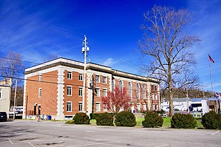
Haywood County is a county located in the U.S. state of North Carolina. As of the 2020 census, the population was 62,089. The county seat and its largest city is Waynesville.

<span class="mw-page-title-main">Canton, North Carolina</span> Town in North Carolina, United States

Canton is the second largest town in Haywood County, North Carolina, United States. It is located about 17 miles (27 km) west of Asheville and is part of that city's metropolitan area. The town is named after the city of Canton, Ohio. The population was 4,227 at the 2010 census.

<span class="mw-page-title-main">Townsend, Tennessee</span> City in Tennessee, United States

Townsend is a city in Blount County, Tennessee. The city was chartered in 1921 by persons who were involved with the Little River Railroad and Lumber Company. The population was 550 at the 2020 census. For thousands of years a site of Native American occupation by varying cultures, Townsend is one of three "gateways" to the Great Smoky Mountains National Park. It has several museums and attractions relating to the natural and human history of the Great Smokies.

<span class="mw-page-title-main">Newport, Tennessee</span> City and county seat of Cocke County, Tennessee, United States

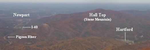
Newport is a city in and the county seat of Cocke County, Tennessee, United States. The population was 6,945 at the 2010 census, down from 7,242 at the 2000 census. The estimated population in 2018 was 6,801. It is located along the Pigeon River.

<span class="mw-page-title-main">Gatlinburg, Tennessee</span> City in Tennessee, United States

Gatlinburg is a mountain resort city in Sevier County, Tennessee. It is located 39 miles (63 km) southeast of Knoxville and had a population of 3,944 at the 2010 Census and a U.S. Census population of 3,577 in 2020. It is a popular vacation resort, as it rests on the border of Great Smoky Mountains National Park along U.S. Route 441, which connects to Cherokee, North Carolina, on the southeast side of the national park. Prior to incorporation, the town was known as White Oak Flats, or just simply White Oak.

<span class="mw-page-title-main">Pigeon Forge, Tennessee</span> City in Tennessee, United States

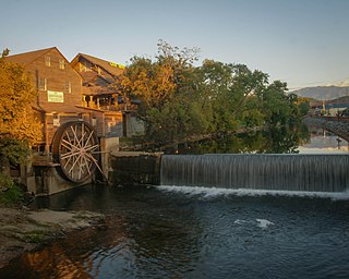
Pigeon Forge is a mountain resort city in Sevier County, Tennessee, United States. As of the 2020 census, the city had a total population of 6,343. Situated just 5 miles (8 km) north of Great Smoky Mountains National Park, Pigeon Forge is a tourist destination that caters primarily to Southern culture and country music fans. The city's attractions include Dollywood and Dollywood's Splash Country as well as numerous gift shops, outlet malls, amusement rides, and musical theaters.

<span class="mw-page-title-main">French Broad River</span> River in North Carolina and Tennessee, United States

The French Broad River is a river in the U.S. states of North Carolina and Tennessee. It flows 218 miles (351 km) from near the town of Rosman in Transylvania County, North Carolina, into Tennessee, where its confluence with the Holston River at Knoxville forms the beginning of the Tennessee River. The river flows through the counties of Transylvania, Buncombe, Henderson, and Madison in North Carolina, and Cocke, Jefferson, Sevier, and Knox in Tennessee. It drains large portions of the Pisgah National Forest and the Cherokee National Forest.

<span class="mw-page-title-main">Great Smoky Mountains</span> American mountain range along North Carolina/Tennessee border

The Great Smoky Mountains are a mountain range rising along the Tennessee–North Carolina border in the southeastern United States. They are a subrange of the Appalachian Mountains, and form part of the Blue Ridge Physiographic Province. The range is sometimes called the Smoky Mountains and the name is commonly shortened to the Smokies. The Great Smokies are best known as the home of the Great Smoky Mountains National Park, which protects most of the range. The park was established in 1934, and, with over 11 million visits per year, it is the most visited national park in the United States.

<span class="mw-page-title-main">U.S. Route 321</span> Highway in the United States

U.S. Route 321 (US 321) is a spur of U.S. Route 21. It runs for 516.9 miles (831.9 km) from Hardeeville, South Carolina to Lenoir City, Tennessee; with both serving as southern termini. It reaches its northernmost point at Elizabethton, Tennessee, just northeast of Johnson City. Because of its unusual "north–south–north" routing, U.S. Route 321 intersects both Interstate 40 and U.S. Route 70 three separate times. The highway serves different roles in each state: An alternate route to interstates in South Carolina, a major highway in North Carolina, and a scenic route in Tennessee.

<span class="mw-page-title-main">Pigeon River (Tennessee–North Carolina)</span> U.S. river

The Pigeon River of Western North Carolina and East Tennessee rises above Canton, North Carolina, is impounded by Walters Dam, enters Tennessee, and flows into the French Broad River, just past Newport, Tennessee. The river traverses the Pisgah National Forest and the Cherokee National Forest, and drains much of the northeastern Great Smoky Mountains National Park.

<span class="mw-page-title-main">Foothills Parkway</span> National parkway in Tennessee

The Foothills Parkway is a national parkway which traverses the foothills of the northern Great Smoky Mountains in East Tennessee, located in the southeastern United States. The 72.1-mile (114 km) parkway will connect U.S. Route 129 along the Little Tennessee River in the west with Interstate 40 (I-40) along the Pigeon River in the east.

<span class="mw-page-title-main">Happy Valley, Blount County, Tennessee</span> Unincorporated community in Tennessee, United States

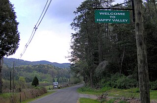
Happy Valley is an unincorporated community in Blount County, Tennessee, near the Great Smoky Mountains National Park. Although it is not a census-designated place, the ZIP Code Tabulation Area for the ZIP Code (37878) that serves Happy Valley had a population of 529 as of the 2000 U.S. Census.

<span class="mw-page-title-main">The Sugarlands</span> Valley in the north-central Great Smoky Mountains

The Sugarlands is a valley in the north-central Great Smoky Mountains, located in the Southeastern United States. Formerly home to a string of small Appalachian communities, the valley is now the location of the Great Smoky Mountains National Park headquarters and the Sugarlands Visitor Center. Lying just south of Gatlinburg, the Sugarlands is one of the park's most popular access points.

<span class="mw-page-title-main">Cosby, Tennessee</span> Census-designated place in Tennessee, United States

Cosby is a census-designated place (CDP) and unincorporated community in Cocke County in the U.S. state of Tennessee. The population of the Cosby CDP according to the 2020 census was 807. The community has given its name to the northeastern section of the Great Smoky Mountains National Park, which forms its southern boundary. Cosby's zip code also extends to into Sevier County, and borders the town of Pittman Center.

<span class="mw-page-title-main">Del Rio, Tennessee</span> Unincorporated community in Tennessee, United States

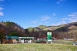
Del Rio is an unincorporated community in Cocke County, Tennessee, United States. Although it is not a census-designated place, the ZIP Code Tabulation Area for the ZIP Code (37727) that serves Del Rio had a population of 2,138, according to the 2000 census.

<span class="mw-page-title-main">Walland, Tennessee</span> CDP in Tennessee, United States

Walland is an unincorporated community and census-designated place (CDP) in Blount County, Tennessee. Its population was 281 as of the 2020 census. Walland is the site of a post office and is the place name associated with zip code 37886, which covers an area beyond the Walland community.

<span class="mw-page-title-main">Mount Sterling (Great Smoky Mountains)</span>

Alexander Alan Arthur was a Scottish-born engineer and entrepreneur active primarily in the southeastern United States in the latter half of the 19th century. Flamboyant, charismatic, and energetic, Arthur used his prominent American and European financial connections to fund numerous business ventures, most of which were overly ambitious and ultimately failed. A proponent of economic advancement in what became known as the New South, Arthur played a primary role in the development of the Cumberland Gap area, and in the course of his endeavors established the cities of Middlesboro, Kentucky and Harrogate, Tennessee. The community of Arthur, Tennessee, is named for him.

References

  1. 1 2 U.S. Geological Survey Geographic Names Information System: Hartford, Tennessee
  2. U.S. Department of Commerce, Bureau of the Census, "Zip Code Tabulation Area 37753 Fact Sheet." Retrieved: December 2, 2007.
  3. "U.S. Census website". United States Census Bureau . Retrieved January 31, 2008.
  4. "US Gazetteer files: 2010, 2000, and 1990". United States Census Bureau. February 12, 2011. Retrieved April 23, 2011.
  5. 1 2 Rolfe Godshalk (editor), "Hartford," Newport (Newport, Tenn.: Clifton Club, 1970), 60-62.
  6. Rolfe Godshalk (editor), "Newport," Newport (Newport, Tenn.: Clifton Club, 1970), 35-49.
  7. Mary Bell Smith, In the Shadow of the White Rock (Boone, N.C.: Minor's Publishing Company, 1979), 18-20.
  8. Mary Bell Smith, In the Shadow of the White Rock (Boone, N.C.: Minor's Publishing Company, 1979), 20-21.
  9. Mary Bell Smith, In the Shadow of the White Rock (Boone, N.C.: Minor's Publishing Company, 1979), 16-21.
  10. Mary Bell Smith, In the Shadow of the White Rock (Boone, N.C.: Minor's Publishing Company, 1979), 16.
  11. Mary Bell Smith, In the Shadow of the White Rock (Boone, N.C.: Minor's Publishing Company, 1979), 22.
  12. Rolfe Godshalk (editor), "Hartford," Newport (Newport, Tenn.: Clifton Club, 1970), 62.
  13. Rebecca Bowe, "Enviro Triumph or Dirty Bird? Local Activists Challenge Pigeon River Success Story." The Mountain Xpress, Vol. 13 no. 33 (March 14, 2007). Retrieved: September 7, 2007.
  14. 1 2 Robert Zelnick, "Al Gore: A Case Study Archived September 27, 2007, at the Wayback Machine ." Hoover Institute Digest, 1999 no. 3. Retrieved: September 7, 2007.
  15. "Pigeon River Fish Termed Safe To Eat." The News & Observer Publishing Company, January 12, 2007. Retrieved: September 7, 2007.