Hope Valley was the first full-fledged country club community in the suburbs of Durham, Durham County, North Carolina. It is developed around an 18-hole Donald Ross golf course. Created in 1925-26 just before the stock market crash of 1929, Hope Valley remained a unique rural colony until after World War II. Well outside the city limits Hope Valley was situated between Durham and Chapel Hill, and their university campuses, Duke and UNC Chapel Hill. It was one of North Carolina's first suburbs designed to be completely serviced by the automobile, well beyond urban transportation routes. It was listed on the National Register of Historic Places in 2009 as the Hope Valley Historic District, a national historic district.
The neighborhoods of Hartford, Connecticut in the United States are varied and historic.
Prospect Hill is a neighborhood of the city of New Haven, Connecticut located in the north central portion of the city, directly north of Downtown New Haven. The neighborhood contains residences, institutional buildings of Albertus Magnus University and a portion of the main campus of Yale University, including the Science Hill area, the Hillhouse Avenue area and the Yale Peabody Museum. The City of New Haven defines the neighborhood to be the region bounded by the town of Hamden in the north, Winchester Avenue in the west, Munson Street/Hillside Place/Prospect Street in the southwest, Trumbull Street in the south, and Whitney Avenue in the east. Prospect Street is the main thoroughfare through the neighborhood.

The Whitney Avenue Historic District is a historic district in the East Rock neighborhood of New Haven, Connecticut. It is a 203-acre (82 ha) district which included 1,084 contributing buildings when it was listed on the National Register of Historic Places in 1989.

The Wianno Club is a historic club at 107 Sea View Avenue in Osterville, Massachusetts. The club began as the Cotocheset House, a Shingle-style structure built in 1882 on the site of a grander hotel that burned down in 1881. This hotel was the centerpiece of a major resort development for the wealthy that was mostly developed prior to World War I. In 1916 the newly founded club purchased the hotel property. The club built a nine-hole golf course on the original land purchase now occupied by holes numbered 13-18. The 16th was the first hole, and the Swan residence behind the hole was built as the original clubhouse. Additional land was assembled on the west side of Parker Road and north of West Bay Road and in 1919, Donald Ross was hired to redesign the original nine and to create a new nine.

The West End South Historic District encompasses a neighborhood of mid 19th to early 20th century residential architecture in western Hartford, Connecticut and eastern West Hartford, Connecticut. Roughly bounded by Prospect and South Whitney Streets, West Boulevard, and Farmington Avenue, the area includes a large number of Colonial Revival and Queen Anne houses, as well as numerous buildings in other period styles, with only a small number of losses. It was listed on the National Register of Historic Places in 1985.

The West Hill Historic District is a prestigious residential subdivision of the town of West Hartford, Connecticut. Originally the site of the estate of Cornelius J. Vanderbilt, son of transportation magnate Cornelius Vanderbilt, it was developed as a planned subdivision of upper-class residences in the 1920s. It was established as a local historic district in 1988, and was listed on the National Register of Historic Places in 1996.

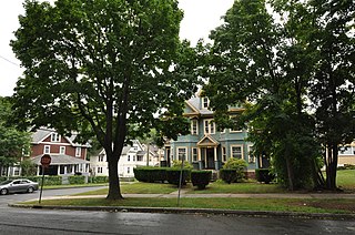
The Beaver Hills Historic District is a 97-acre (39 ha) historic district in the Beaver Hills neighborhood of New Haven, Connecticut. It was listed on the National Register of Historic Places in 1986. In 1986, it included 235 contributing buildings.

Newington Junction is a section of the town of Newington, Connecticut. It is centered at the intersection of Willard Avenue and West Hill Road in the northwestern part of the town, in the area generally just south of the Hartford city line. The name of the area refers to the railroad junction where the railroad line from New Haven meets with the railroad line from Bristol and Waterbury. The development of Newington Junction as a result of the railroad was instrumental in the separation of the town of Newington from its mother town of Wethersfield.

The Hillside Historic District in Waterbury, Connecticut is a 106-acre (43 ha) historic district that was listed on the National Register of Historic Places (NRHP) in 1987. It encompasses a residential area north of the city's central business district, and is bounded on the south by West Main Street, the west by Willow Avenue and Cliff and Frederick Streets, on the north by Buckingham Street and Woodland Terrace, and on the east by Cooke Street. Developed principally over an 80-year period between 1840 and 1920, it includes a cross-section of architectural styles of the 19th and early 20th centuries. The area was a desirable neighborhood of the city for much of this time, and was home to a number of the city's elite. In 1987, it included 395 buildings deemed to contribute to the historic character of the area, and one other contributing structure. It includes the Wilby High School and the Benedict-Miller House, which are both separately listed. 32 Hillside Road, a several acre property that includes the Benedict Miller House, was the original site of The University of Connecticut's Waterbury Branch until 2003.

Lindbergh Forest is a neighborhood in Knoxville, Tennessee, United States, located off Chapman Highway (US-441) in South Knoxville, that is listed on the National Register of Historic Places as an historic district. Initially developed in the late 1920s as one of Knoxville's first automobile suburbs, the neighborhood is now noted for its late-1920s and early-1930s residential architecture, and the use of East Tennessee marble detailing. The neighborhood also contains two of Knoxville's five surviving Lustron houses. In 1998, several of its houses were added to the National Register of Historic Places as the Lindbergh Forest Historic District.

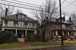
The Prospect Avenue Historic District encompasses a predominantly residential area in western Hartford and eastern West Hartford, Connecticut. The 300-acre (120 ha) historic district extends along Prospect Avenue from Albany Avenue to Fern Street, including most of the area between those streets and the Park River to the east, and Sycamore Street and Sycamore Lane to the west. The district includes 240 contributing buildings and 48 non-contributing buildings, most of them residences built between 1880 and 1930. The district was listed on the National Register of Historic Places in 1985.

Forest Park is a Victorian garden district located in Springfield, Massachusetts, developed between 1880 and 1920. It is the city's most populous neighborhood, and surrounds the 735-acre Forest Park, for which the neighborhood is named. The Forest Park neighborhood has nature and recreation within walking distance. To the west, I-91 separates Forest Park from the Connecticut River. A 195-acre section of the neighborhood was listed on the National Register of Historic Places in 1982 as the Forest Park Heights Historic District.
The Buckingham Square District of Hartford, Connecticut encompasses a mixed residential and commercial neighborhood area just south of the city's downtown. It is centered around Buckingham Square, laid out in 1830 on the site of an early colonial-era church. The district includes a concentration of well-preserved Victorian architecture from the 1860s to 1890s. It was listed on the National Register of Historic Places in 1977, and slightly enlarged in 1982.

The West End North Historic District encompasses a neighborhood of late 19th and early 20th century residential architecture in western Hartford, Connecticut and eastern West Hartford, Connecticut. Roughly bounded by Prospect, Elizabeth, and Lorraine Streets and Farmington Avenue, the area includes a large number of Colonial Revival and Queen Anne houses, as well as numerous buildings in other period styles, with only a small number of losses. It was listed on the National Register of Historic Places in 1985.
The Oxford-Whitney Streets District is a historic district encompassing an early-20th century residential area in the West End neighborhood of Hartford, Connecticut. It extends along the east side of Oxford Street between Elizabeth and Cone Streets, and along the west side of Whitney between Fern and Elizabeth, and includes the north side of Fern Street between Whitney and Oxford. Most of the housing, a combination of single and multi-family residences, was built between 1906 and 1919, a period later than the surrounding areas, and is predominantly Colonial Revival in character. It was listed on the National Register of Historic Places in 2010.
The Sisson-South Whitney Historic District encompasses a neighborhood in the West End area of Hartford, Connecticut, that was built out between 1890 and 1930 as a streetcar suburb. It is roughly bounded by Farmington Avenue, South Whitney Street, West Boulevard, and Sisson Avenue, and includes a diversity of residential and commercial architecture, reflective of its initial development and subsequent growth. The district was listed on the National Register of Historic Places in 2013.

The Vine Street Apartment Buildings, many now known as the Horace Bushnell Apartments, are a historic collection of residential apartment blocks at 4-48 Vine Street in Hartford, Connecticut. Built between 1922 and 1925, they consist of eleven brick buildings sharing massing, scale, and setting, with a cross-section of period building styles. They were listed on the National Register of Historic Places in 2012.

The Upper Albany Historic District encompasses a predominantly residential area of the North End of Hartford, Connecticut. It extends along Albany Avenue between Garden and Woodland Streets, including side streets to the south, and extends northward to include the southern portion of Keney Park. This area was developed in the first two decades of the 20th century, and has a fine array of period middle-class housing in the Queen Anne and Colonial Revival styles. It was listed on the National Register of Historic Places in 1986.

The West End Historic District encompasses a predominantly residential area west of downtown New Britain, Connecticut. Forming a rough C shape around the west part of Walnut Hill Park, the area was developed in the late 19th century as one of its premier upper-class neighborhoods, home to business and civic leaders, with a fine array of late 19th and early 20th century architecture. It was listed on the National Register of Historic Places in 1998.


