Ring of Brodgar – a stone circle 104metres in diameter, originally composed of 60 stones set within a circular ditch up to 3metres deep and 10metres wide, forming a henge monument. It has been estimated that the structure took 80,000 man-hours to construct.[4][5]
Ness of Brodgar is an archaeological site between the Ring of Brodgar and the Stones of Stenness that has provided evidence of housing, decorated stone slabs, a massive stone wall with foundations, and a large building described as a Neolithic "cathedral".[7][8] Although it is not part of the World Heritage Site, the Ness of Brodgar "contribute[s] greatly to our understanding of the WHS" according to Historic Scotland, which manages most of the site.[9]
In 2008, UNESCO expressed concern about plans by the local council to "erect three large 72 metres wind turbines to the north-west of the Stones of Stenness and the Ring of Brogdar" that might damage the site.[10] In 2019, a risk assessment was performed to assess the site's vulnerability to climate change. The report by Historic Environment Scotland, the Orkney Islands Council and others concludes that the entire World Heritage Site, and in particular Skara Brae, is "extremely vulnerable" to climate change due to rising sea levels, increased rainfall and other factors; it also highlights the risk that Skara Brae could be partially destroyed by one unusually severe storm.[11]
The first application of the Climate Vulnerability Index to a Cultural World Heritage property took place at the Heart of Neolithic Orkney in April 2019.[12]
A chambered cairn is a burial monument, usually constructed during the Neolithic, consisting of a sizeable chamber around and over which a cairn of stones was constructed. Some chambered cairns are also passage-graves. They are found throughout Britain and Ireland, with the largest number in Scotland.
Maeshowe is a Neolithic chambered cairn and passage grave situated on Mainland Orkney, Scotland. It was probably built around 2800 BC. In the archaeology of Scotland, it gives its name to the Maeshowe type of chambered cairn, which is limited to Orkney.
Orkney, also known as the Orkney Islands, is an archipelago in the Northern Isles of Scotland, situated off the north coast of the island of Great Britain. Orkney is 10 miles (16 km) north of the coast of Caithness and has about 70 islands, of which 20 are inhabited. The largest island, the Mainland, has an area of 523 square kilometres (202 sq mi), making it the sixth-largest Scottish island and the tenth-largest island in the British Isles. Orkney's largest settlement, and also its administrative centre, is Kirkwall.
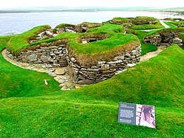
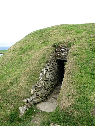
Skara Brae is a stone-built Neolithic settlement, located on the Bay of Skaill on the west coast of Mainland, the largest island in the Orkney archipelago of Scotland. It consisted of ten clustered houses, made of flagstones, in earthen dams that provided support for the walls; the houses included stone hearths, beds, and cupboards. A primitive sewer system, with "toilets" and drains in each house, included water used to flush waste into a drain and out to the ocean.
The Ring of Brodgar is a Neolithic henge and stone circle about 6 miles north-east of Stromness on Mainland, the largest island in Orkney, Scotland. It is part of the UNESCO World Heritage Site known as the Heart of Neolithic Orkney.
The Knap of Howar on the island of Papa Westray in Orkney, Scotland is a Neolithic farmstead which may be the oldest preserved stone house in northern Europe. Radiocarbon dating shows that it was occupied from 3700 BC to 2800 BC, earlier than the similar houses in the settlement at Skara Brae on the Orkney Mainland.
Unstan ware is the name used by archaeologists for a type of finely made and decorated Neolithic pottery from the 4th and 3rd millennia BC. Typical are elegant and distinctive shallow bowls with a band of grooved patterning below the rim, a type of decoration which was created using a technique known as "stab-and-drag". A second version consists of undecorated, round-bottomed bowls. Some of the bowls had bits of volcanic rock included in the clay to make them stronger. Bone tools were used to burnish the surfaces to make them shiny and impermeable.
The Standing Stones of Stenness is a Neolithic monument five miles northeast of Stromness on the mainland of Orkney, Scotland. This may be the oldest henge site in the British Isles. Various traditions associated with the stones survived into the modern era and they form part of the Heart of Neolithic Orkney World Heritage Site. They are looked after by Historic Environment Scotland as a scheduled monument.
The Neolithic Barnhouse Settlement is sited by the shore of Loch of Harray, Orkney Mainland, Scotland, not far from the Standing Stones of Stenness, about 5 miles north-east of Stromness.
The Dwarfie Stane is a megalithic chambered tomb carved out of a titanic block of Devonian Old Red Sandstone located in a steep-sided glaciated valley between the settlements of Quoys and Rackwick on Hoy, an island in Orkney, Scotland. The stone is a glacial erratic located in desolate peatland. The site is managed by Historic Environment Scotland.
The Loch of Stenness is a large brackish loch on Mainland, Orkney, Scotland and is named for the parish of Stenness. It is 2 miles northeast of the town of Stromness, lies immediately to the south of the Loch of Harray and is close to the World Heritage neolithic sites of the Stones of Stenness and Ring of Brodgar. In Old Norse its name was Steinnesvatn.
The Loch of Harray is the largest loch of Mainland Orkney, Scotland and is named for the parish of Harray. It lies immediately north of the Loch of Stenness and is close to the World Heritage neolithic sites of the Stones of Stenness and Ring of Brodgar. In Old Norse its name was Heraðvatn.
Prehistoric Orkney refers only to the prehistory of the Orkney archipelago of Scotland that begins with human occupation. Although some records referring to Orkney survive that were written during the Roman invasions of Scotland, “prehistory” in northern Scotland is defined as lasting until the start of Scotland's Early Historic Period.
Unstan is a Neolithic chambered cairn located about 2 mi (3 km) north-east of Stromness on Mainland, Orkney, Scotland. The tomb was built on a promontory that extends into the Loch of Stenness near the settlement of Howe. Unstan is notable as an atypical hybrid of the two main types of chambered cairn found in Orkney, and as the location of the first discovery of a type of pottery that now bears the name of the tomb. The site is in the care of Historic Environment Scotland as a scheduled monument.
The Ness of Brodgar is an archaeological site covering 2.5 hectares between the Ring of Brodgar and the Stones of Stenness in the Heart of Neolithic Orkney World Heritage Site in Orkney, Scotland. Excavations at the site began in 2003. The site has provided evidence of decorated stone slabs, a stone wall 6 metres (20 ft) thick with foundations, and a large building described as a Neolithic temple. The earliest structures were built between 3,300 and 3,200 BC, and the site had been closed down and partly dismantled by 2,200 BC. It was the main subject of a 2016 BBC Scotland documentary, Britain’s Ancient Capital: Secrets of Orkney, presented by Neil Oliver, Chris Packham, Shini Somara, Andy Torbet and Doug Allan. For preservation, the site is closed during the winter months and covered in polyethylene plastic and tyres to protect it from the environment.
Hoy and West Mainland is a national scenic area (NSA) covering parts of the islands of Hoy and Mainland in the Orkney Islands of Scotland, as well as parts of the surrounding sea. It is one of 40 such areas in Scotland, which are defined so as to identify areas of exceptional scenery and to ensure its protection by restricting certain forms of development. The Hoy and West Mainland NSA covers 24,407 ha in total, consisting of 16,479 ha of land with a further 7928 ha being marine.
This page is based on this Wikipedia article Text is available under the CC BY-SA 4.0 license; additional terms may apply. Images, videos and audio are available under their respective licenses.