
A dragon is a magical legendary creature that appears in the folklore of multiple cultures worldwide. Beliefs about dragons vary considerably through regions, but dragons in Western cultures since the High Middle Ages have often been depicted as winged, horned, and capable of breathing fire. Dragons in eastern cultures are usually depicted as wingless, four-legged, serpentine creatures with above-average intelligence. Commonalities between dragons' traits are often a hybridization of feline, reptilian, mammalian, and avian features. Some scholars believe large extinct or migrating crocodiles bear the closest resemblance, especially when encountered in forested or swampy areas, and are most likely the template of modern Asian dragon imagery.

Martin Waldseemüller was a German cartographer and humanist scholar. Sometimes known by the Latinized form of his name, Hylacomylus, his work was influential among contemporary cartographers. His collaborator Matthias Ringmann and he are credited with the first recorded usage of the word America to name a portion of the New World in honour of Italian explorer Amerigo Vespucci in a world map they delineated in 1507. Waldseemüller was also the first to map South America as a continent separate from Asia, the first to produce a printed globe, and the first to create a printed wall map of Europe. A set of his maps printed as an appendix to the 1513 edition of Ptolemy's Geography is considered to be the first example of a modern atlas.
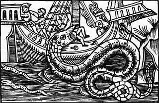
A sea serpent is a type of sea monster described in various mythologies, most notably Mesopotamian (Tiamat), Judaeo-Christian (Leviathan), Greek, and Norse (Jörmungandr).
The European dragon is a legendary creature in folklore and mythology among the overlapping cultures of Europe.

A globe is a spherical model of Earth, of some other celestial body, or of the celestial sphere. Globes serve purposes similar to maps, but, unlike maps, they do not distort the surface that they portray except to scale it down. A model globe of Earth is called a terrestrial globe. A model globe of the celestial sphere is called a celestial globe.
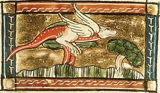
The jaculus is a small mythical serpent or dragon. It can be shown with wings and sometimes has front legs. It is also sometimes known as the javelin snake.

The Cantino planisphere or Cantino world map is a manuscript Portuguese world map preserved at the Biblioteca Estense in Modena, Italy. It is named after Alberto Cantino, an agent for the Duke of Ferrara, who successfully smuggled it from Portugal to Italy in 1502. It measures 220 x 105 cm.
Terra incognita or terra ignota is a term used in cartography for regions that have not been mapped or documented. The expression is believed to be first seen in Ptolemy's Geography c. 150. The term was reintroduced in the 15th century from the rediscovery of Ptolemy's work during the Age of Discovery. The equivalent on French maps would be terres inconnues, and some English maps may show Parts Unknown.
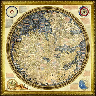
The Fra Mauro map is a map of the world made around 1450 by the Italian (Venetian) cartographer Fra Mauro, which is “considered the greatest memorial of medieval cartography." It is a circular planisphere drawn on parchment and set in a wooden frame that measures over two by two meters. Including Asia, the Indian Ocean, Africa, Europe, and the Atlantic, it is orientated with south at the top. The map is usually on display in the Biblioteca Nazionale Marciana in Venice in Italy.
The earliest known world maps date to classical antiquity, the oldest examples of the 6th to 5th centuries BCE still based on the flat Earth paradigm. World maps assuming a spherical Earth first appear in the Hellenistic period. The developments of Greek geography during this time, notably by Eratosthenes and Posidonius culminated in the Roman era, with Ptolemy's world map, which would remain authoritative throughout the Middle Ages. Since Ptolemy, knowledge of the approximate size of the Earth allowed cartographers to estimate the extent of their geographical knowledge, and to indicate parts of the planet known to exist but not yet explored as terra incognita.
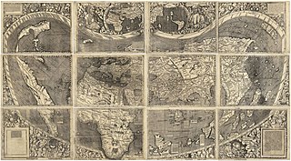
The Waldseemüller map or Universalis Cosmographia is a printed wall map of the world by German cartographer Martin Waldseemüller, originally published in April 1507. It is known as the first map to use the name "America". The name America is placed on South America on the main map. As explained in Cosmographiae Introductio, the name was bestowed in honor of the Italian Amerigo Vespucci.
The Johannes Schöner globes are a series of globes made by Johannes Schöner (1477–1547), the first being made in 1515. Schöner's globes are some of the oldest still in existence. Some of them are said by some authors to show parts of the world that were not yet known to Europeans, such as the Magellan Strait and the Antarctic.
Johannes Ruysch, a.k.a. Johann Ruijsch or Giovanni Ruisch was an explorer, cartographer, astronomer, manuscript illustrator and painter from the Low Countries who produced a famous map of the world: the second oldest known printed representation of the New World. This Ruysch map was published and widely distributed in 1507.
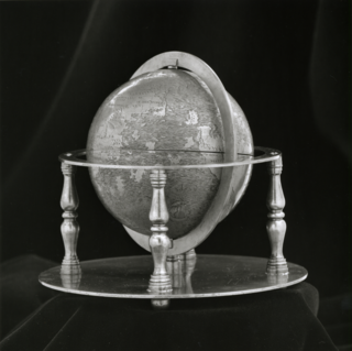
The Hunt–Lenox Globe or Lenox Globe, dating from about 1508, is the second- or third-oldest known terrestrial globe, after the Erdapfel of Martin Behaim (1492) and the Ostrich Egg Globe. The Hunt-Lenox Globe is housed by the Rare Book Division of the New York Public Library. It is notable as one of only two known instances of a historical map actually using the phrase HC SVNT DRACONES.

The Jagiellonian globe, also known as the Globus Jagellonicus, is a mechanical armillary sphere made in France before 1510. It is an astronomical instrument and a universal clock tracking both local solar time and sidereal time. The central brass sphere is engraved with a map of Earth and contains the clock mechanism. It is the oldest extant globe to use the name America.

In Icelandic folklore, the Lagarfljótsormur or Lagarfljót worm is a lake monster purported to live in Lagarfljót, a lake by the town of Egilsstaðir.


