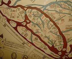
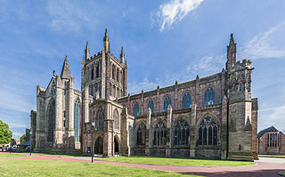
The Hereford Mappa Mundi (Latin: mappa mundi) is the largest medieval map still known to exist, depicting the known world. It is a religious rather than literal depiction, featuring heaven, hell and the path to salvation. The map is drawn in a form deriving from the T and O pattern, dating from c. 1300. It is displayed at Hereford Cathedral in Hereford, England.[1] The map was created with the intent of its being appreciated as an intricate work of art rather than as a navigational tool.[2] Sources for the information presented on the map include the Alexander tradition, medieval bestiaries and Monstrous races tradition, as well as the Bible.
Although the evidence is circumstantial, modern scholarship links the map with the promotion of the cult of Thomas de Cantilupe,[3] and with a justification of the expulsion of Jewry from England.[4] Potentially antisemitic images include a horned Moses and a depiction of Jews worshipping the Golden Calf in the form of a Saracen devil. The map also seems to reflect very patriarchical views of women as inherently sinful, including figures such as the wife of Lot being turned into a pillar of salt for gazing at the city of Sodom. Cantilupe was known for his dislike of Jews and was regarded as misogynistic even by the standards of his own time.[3]
The map would have functioned as an object to show people visiting Cantilupe's cult, and guides would have described and helped visitors to understand the content. The idea of looking, reading and hearing the stories is mentioned on the map itself. There would not have always been single, fixed ideas attached to the images, which would be interpreted symbolically, and through juxtaposition and proximity. Text in Latin and French would help guides and international visitors to understand something of its meaning.
The map suffered neglect in the post-Reformation period. By the 19th century, it was in need of repair, and it was repaired at the British Museum. However, the side panels of the original triptych were lost, and the map was detached from its wooden frame panel. The cathedral proposed to sell the map in 1988, but fundraising kept the map from sale, and it was moved to a dedicated building in 1996.
A larger mappa mundi, the Ebstorf Map, was destroyed by Allied bombing in 1943, though photographs of it survive.
Post-Reformation history
The Hereford Mappa Mundi hung, with little regard, for many years on a wall of a choir aisle in the cathedral. During the troubled times of the Commonwealth the map had been laid beneath the floor of Bishop Audley's Chantry, where it remained secreted for some time. In 1855 it was cleaned and repaired at the British Museum. During the Second World War, for safety reasons, the mappa mundi and other valuable manuscripts from Hereford Cathedral Library were kept elsewhere and returned to the collection in 1946.[5]
In 1988, a financial crisis in the Diocese of Hereford caused the Dean and Chapter to propose selling the mappa mundi.[6] After much controversy, large donations from the National Heritage Memorial Fund, Paul Getty and members of the public kept the map in Hereford and allowed the construction of a new library designed by Sir William Whitfield to house the map and the chained libraries of the Cathedral and of All Saints' Church. The new Library Building in the south east corner of the cathedral close opened in 1996.[5] An open-access high-resolution digital image of the map with more than 1,000 place and name annotations is included among the thirteen medieval maps of the world edited in the Virtual Mappa project. In 1991 British Rail Class 31 locomotive No.31405 was named "Mappa Mundi" at a ceremony at the Hereford Rail Day.[citation needed]
Original sources
The map is based on traditional accounts and earlier maps such as the one of the Beatus of Liébana codex, and is very similar to the Ebstorf Map, the Psalter world map, and the Sawley map (erroneously for considerable time called the Henry of Mainz map). It is not a literal map, and does not conform to geographical knowledge of the time.
Among the most important sources for the map are the Historiarum adversum paganos libri septem (Seven Books against the Pagans) of Orosius, which is cited on the map. The map also draws on the Alexander myths, bestiaries and commonly accepted ideas of Monstrous Races.[7]
Interpretation and purpose
1784 sketch of the triptych containing the Hereford Mappa Mundi, showing side panels
The map has been interpreted from a topographical and encylopedic perspective, but more recent approaches have attempted to see the map as a work of art, that conveys meanings through symbolism and associations. Interpretations of the Hereford Mappa Mundi are difficult, because the original context and purpose are lost.[8] However, it is known that it formed the central panel of a triptych, a drawing of which is held by the British Library. The left panel depicted the angel Gabriel, and the right the Virgin annunciate.[9] This gives the map particular associations with the cult of the Virgin Mary, which was very prominent in Christian worship at the time, and highly developed at Hereford.[10]
There is an emerging consensus that the map played a role in promoting the cult of Thomas de Cantilupe,[11] who was later accepted as a Saint by the Holy See. This is partly based on examination of features of the cathedral and conjecture about the original placement of the triptych. There is however disagreement about the timing of its installation, whether shortly before or somewhat after 1290.[12]
The map needs therefore to be understood as an object used within that cult, as a didactic and religious object, that would have been looked at by an international audience, some of whom would be able to read the Latin or French inscriptions. It is likely that guides, whether highly educated and literate, or less so, would help ensure those looking at the map were able to interpret the figures in the correct manner. Guides could have included the cathedral canons, for example. The map itself shows some evidence that it was used this way, for instance, Hereford has nearly disappeared from it, presumably from repeated touching; and one of the map's main inscriptions states: "Let all who have this history — or who shall hear, or read, or see it — pray to Jesus in his divinity."[13]
Placement and Cantilupe cult
Dan Terkla places the map in the north transept's east wall next to de Cantilupe's shrine. Among the evidence he cites are masonry remains that can be observed at the proposed site of the triptych, including a set of eight square stone inserts, placed to block holes potentially used for wooden or stone supports (corbels) for the display. This would align with the stained glass windows above. The supports match the length of the opened triptych panels at about 3 meters wide, with a small overhang. He contends that the triptych would have fitted neatly, aligning with other features and presenting the map's key features at an appropriate height, with Jerusalem at 129cm and the Last Judgement at 215cm.[14] There are however potential objections to this theory; the dimensions cited by Terkla may underestimate the size of the triptych, and in any case, it would be very unusual for a decorative object to be placed so near a shrine.[15]
Another theory from Thomas de Wesselow places the triptych on another wall on the south aisle of the choir adjacent to de Cantilupe's tomb. This wall is recorded as having metal hooks which could have acted as supports for the triptych. Aligned wooden fittings on the back of the surviving central section of the triptych give credence to this view.[16]
In either case, the map within its triptych would have formed a central focus for pilgrims seeking divine intervention from Cantilupe. The map would be expected to reflect central concerns and beliefs or teachings of Cantilupe. His views depicted on the map may include his aversion to Jews and his misogyny. In Debra Strickland's view, the map reflects a post-Expulsion narrative, conflating the Exodus of the Bible with the contemporary expulsion, and as outlined below, setting out why Christians should believe that Jews are deserving of such punishment.[17]
Authorship and patronage
The production of the map is likely to have involved the patronage of up to four men, Thomas de Cantilupe, Richard of Haldingham, Richard de Bello and Richard Swinefield, the Bishop of Worcester after Cantilupe. Richard of Haldingham, who died in 1278, may have been a senior relative of de Bello, and appears to be credited on the map as the designer (who "made and laid it out"). Richard de Bello's career from the later 1280 and 90s is linked to Swinefield's patronage in Lincoln, where Swinefield was briefly treasurer. Finally, of course, in creating the map for the Cantilupe cult, it was a sign of Swinefield's gratitude to his benefactor.[18] However, these possible links remain speculative, and it is equally possible that Richard of Haldingham and Swinefield knew each other directly, even assuming that the Haldingham that died in 1278 was the original drafter identified on the map.[19]
There is possible evidence of female patronage contributing to the map's production, in the single well-dressed, arisocratic female figure among the elect drawn on the top left handside of the map, and in the drawing of the modestly dressed and therefore piously presented handmaiden offering the Virgin Mary a crown.[20]
It was long believed that the mappa mundi was created, not in Hereford, but in Lincoln because the city of Lincoln was drawn in considerable detail and was represented by a cathedral (accurately) located on a hill near a river.[21] Hereford, on the other hand, was represented only by a cathedral, a seeming afterthought drawn by a different hand when compared with other features of the map.[22] However, more recent research on the origin of the wood in the frame suggests it may in fact have been created in or around Hereford.[23]
Strickland has attempted to interpret the map's images of medieval Jewry and associated bible stories to understand what it may have been trying to convey about Jews and Judaism. She notes that this was a particular concern in England, where the Jews were expelled in 1290, and also of Hereford catherdral and its leadership, who had been in conflict with the local Jewish population.[17] The map has several depictions of Jews (Judaei), mostly relating to depictions of the Exodus.[17] These are unusual, not least as they would normally be identified as historical "Israelites" or similar formulations rather than by the contemporary term "Jews".[24] The Exodus cycle is particularly prominent, indicating unusual significance, as it is not found on other similar medieval religious maps.[25]
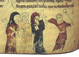
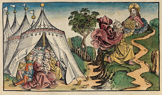
Jews worshipping the Golden Calf presented as a Mahun, or Saracen devil
Some of the images are clearly derogatory and anti-semitic. For instance, within the Exodus cycle, a prominent scene depicts the worship of the Golden Calf. However, the Golden Calf is depicted as a devil defacating coins onto its altar.[26] The devil is labelled "Mahu(n)", a name for imaginary idols believed to be worshipped by Muslims, building an association with figures elsewhere on the map negatively representing Saracens.[27] The scene also depicts Christian crosses as present on the altar. This arguably moves the image into a depiction of host desecration, but at a minimum places the Jews in a position of mocking Christians. The four men labelled "Judaei" worshipping the devil hold a blank scroll, a symbol used to denote the association of Jews with scrolls containing the Word of God, yet in the view of Christians, having an inability to understand and accept it.[28] Overall, the Golden Calf scene, by labelling Israelites as "Jews", associating them with the mockery of Christians and with conceptions of Muslims or Saracens of the period through the "Mahun" figure, connects the Exodus story with contemporary Jews.[28]
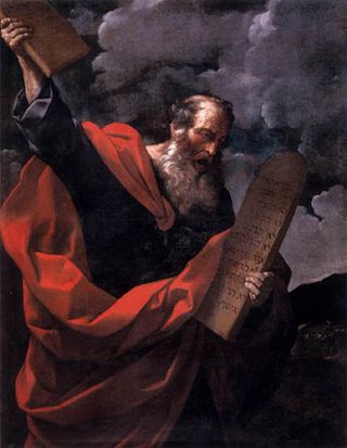
The "blank scroll" of the Golden Calf scene also connects with the nearby depiction of Moses receiving the Ten Commandments, directly above. This can be read as the Jews receiving the law from God, and then rejecting it, transforming the Exodus story from that of redemption to rejection and damnation.[29]
The Moses figure can also be interpreted negatively. He is depicted with yellow horns, near red coloured seas and as already noted, is close to another devil.[lower-alpha 1] The red and yellow colour combination is well known from other derogatory depictions of Jews, and can be read as reinforcing negative stereotypes of Jews.[31] A coffin with a Christian cross placed next to Moses may represent Joseph's bones being taken back to Israel, but could also represent the contemporary death of the Old Law, God's rejection of the Jews, and the replacement of the Mosaic law by the Christian message. It may recall Jesus' comparison in Matthew 23.27 of the scribes and Pharisees to whitened tombs.[32] Lastly, Moses is placed in proximity to dragons patrolling the entrance to hell, through a diagonal alignment.[32]
The Biblical Exodus can be read as a parallel for the near contemporary 1290 expulsion of the Jews from England. The itinerary has beasts and objects placed near it which may reinforce negative portrayals of Jews. At the start of the Exodus, at Ramasses, a yale and a mandrake stand beside the start of the route. The yale's horns echo those of Moses. The next beast encountered on the path is near the Jews worshipping the Golden Calf is a phoenix. The phoenix symbolised Christ's resurrection, as it emerges intact from fire after three days; in the bestiaries, this was said to echo the prophecy of Jesus that he had the power to lay his life down and take it up again, which had angered the Jews. After three loops representing forty years of travel each, the path encounters the disobedient wife of Lot, on the point of being turned into a pillar of salt for looking back onto the city of Sodom. Here also stands a marsok, with different kinds of feet, which may be linked to the shape changing hyena, itself associated in bestiaries with Jews as an unclean, sex-changing animal. Positioned between the Tower of Babel and Lot's wife, the marsok may also function to connect the Exodus story to the sin of pride. The destination of the Exodus path is Jericho, positioned just above the crucified Christ, whose hand points back to the Jews worshipping the Golden Calf, linking the crucifixion to those deemed responsible in medieval theology.[33]
Jews depicted in the Gog and Magog myth
There are a total of four references to Gog and Magog.[34] At the top left of the map, near the Day of Judgement, is a description of the cannabilism of fili caim maledicti, or "accursed sons of Cain". These Jewish figures are a frequent depiction on medieval maps, and derived from the Alexander cycle myth. They are in the myth fated to fight Christendom at the end of time.[27]
Presentation of women
Strickland notes that the map conveys a "pervasive masculinity: male ecclesiastical headgear, flat chests, beards, tonsures, testicles, and penises abound",[35] and the "entire visual field is enframed, patrolled, and occupied by males".[36] She contrasts this with the female figures, which she believes depict aspects of the prevailing misogynistic depiction of women as fundamentally proud, disobedient and lustful.[37] The Virgin Mary stands in medieval thinking as the role model for women, as virginal and free from sin, and therefore complements rather than subverts this depiction.[10]
Some twenty figures that represent women, of which the most important represents the Virgin Mary, positioned at the top of the map at the Last Judgement, where she bares her breasts in an act of supplication. Other figures include a handmaiden presenting Mary with a crown, and a siren near Jerusalem bearing a mirror. The wife of Lot gazes towards Sodom and Gomorrah, and Noah's wife stands beside him. There are also a prominent female Epiphagus, a Psyllian, and a further twenty other non-human females.[38]
The four most prominent women are positioned around the Tower of Babel, a symbol of the sin of pride, viewed in the Christian morality of the time as the root of all evil, and also the sin most closely associated with women.[38] The Tower of Babel symbolised pride as God cast it down for attempting to reach heaven. In general, women were associated with the related sins of vanity, gluttony, and avarice. Religious teachings recognised the necessity of marriage and reproductive sex, but emphasised virginity as the preferable state. The four women who stand around the tower were those depicted in contemporary Christian morality as having specific failings related to pride. The women and female figures together depict pride, disobedience and sexual misconduct, fulfilling the map's didactic role, in reinforcing "misogynisitic ideologies" and the social control of women.[39]
Contents
Drawn on a single sheet of vellum, it measures 158cm by 133cm,[1] some 52in (130cm) in diameter and is the largest medieval map known still to exist. The writing is in black ink, with additional red and gold, and blue or green for water (with the Red Sea (8) coloured red). It depicts 420 towns, 15 Biblical events, 33 animals and plants, 32 people, and five scenes from classical mythology.[1]
Utilizing the contemporary medieval styled T-O map of the time, the map is a biblically inspired map which shows Jerusalem drawn in the centre of the circle; east is on top, showing the Garden of Eden in a circle at the edge of the world (1).[40] Great Britain is drawn at the northwestern border (bottom left, 22 and 23). Curiously, the labels for Africa and Europe are reversed, with Europe scribed in red and gold as "Africa" and vice versa.[1] The Mediterranean Sea is shown at the bottom center, with the Straits of Gibraltar marking its most western point.[40]
As noted, it does not correspond to the geographical knowledge of the 14th century. For example, the Caspian Sea (5) connects to the encircling ocean (upper left). This is in spite of William of Rubruck's having reported it to be landlocked in 1255, several decades before the map's creation; see also Portolan chart.
Various animals not well known to Europeans at the time, such as elephants and camels, are depicted. Elephants were shown to be very practical beasts of war, as they were strong enough to transport siege equipment across great distances, as well as being capable of supporting platforms from which rows of archers were able to stand and fire, or so envisioned the medieval English cartographers. Mythical beasts such as the legendary monoceros are depicted on the map. A number of monsters and inhuman races are present. One such race is the Blemmyes, a headless tribe whose facial features were situated on their chests.[41]
The "T and O" shape does not imply that its creators believed in a flat Earth. The spherical shape of the Earth was already known to the ancient Greeks and Romans and the idea was never entirely forgotten even in the Middle Ages, and thus the circular representation may well be considered a conventional attempt at a projection: in spite of the acceptance of a spherical Earth, only the known parts of the Northern Hemisphere were believed to be inhabitable by human beings (see antipodes), so that the circular representation remained adequate.[42] The long river on the far right is the River Nile (12), and the T shape is established by the Mediterranean Sea (19-21-25) and the rivers Don (13) and Nile (16).
↑ The "horned" aspect could be due to a mistranslation of Moses as cornuta (horned) in the Vulgate Bible, but this itself may not have been a neutral mistake. There is also evidence of association of Jews with devils in medieval sermons, and in any case, Strickland argues, the audience would be likely to associate horns with devilry. Stephen Bertman makes similar points regarding medieval depictions of a horned Moses.[30]
Related Research Articles
Moses was a Hebrew teacher and leader considered the most important prophet in Judaism and one of the most important prophets in Christianity, Islam, the Baháʼí Faith, and other Abrahamic religions. According to both the Bible and the Quran, Moses was the leader of the Israelites and lawgiver to whom the prophetic authorship of the Torah is attributed.
A mappa mundi is any medieval European map of the world. Such maps range in size and complexity from simple schematic maps 25 millimetres or less across to elaborate wall maps, the largest of which to survive to modern times, the Ebstorf map, was around 3.5 m in diameter. The term derives from the Medieval Latin words mappa and mundus (world).
Moses is a sculpture by the Italian High Renaissance artist Michelangelo, housed in the church of San Pietro in Vincoli in Rome. Commissioned in 1505 by Pope Julius II for his tomb, it depicts the biblical figure Moses with horns on his head, based on a description in chapter 34 of Exodus in the Vulgate, the Latin translation of the Bible used at that time. Some scholars believe the use of horns may often hold an antisemitic implication, while others hold that it is simply a convention based on the translation error.
Hereford Cathedral is the cathedral church of the Anglican Diocese of Hereford in Hereford, England.
According to the Bible and the Quran, the golden calf was a cult image made by the Israelites when Moses went up to Mount Sinai. In Hebrew, the incident is known as "the sin of the calf". It is first mentioned in the Book of Exodus.
The Edict of Expulsion was a royal decree expelling all Jews from the Kingdom of England that was issued by Edward I 18 July 1290; it was the first time a European state is known to have permanently banned their presence. The date of issuance was most likely chosen because it was a Jewish holy day, the ninth of Ab, which commemorates the destruction of Jerusalem and other disasters the Jewish people have experienced. Edward told the sheriffs of all counties he wanted all Jews expelled before All Saints' Day that year.
The first Jews in England arrived after the Norman Conquest of the country by William the Conqueror in 1066, and the first written record of Jewish settlement in England dates from 1070. Jews suffered massacres in 1189–90, and after a period of rising persecution, all Jews were expelled from England after the Edict of Expulsion in 1290.
Thomas de Cantilupe was Lord Chancellor of England and Bishop of Hereford. He was canonised in 1320 by Pope John XXII. He has been noted as "an inveterate enemy of the Jews", and his demands that they be expelled from England were cited in the evidence presented for his canonization.
The Exodus is the founding myth of the Israelites whose narrative is spread over four of the five books of the Pentateuch.
The earliest known world maps date to classical antiquity, the oldest examples of the 6th to 5th centuries BCE still based on the flat Earth paradigm. World maps assuming a spherical Earth first appear in the Hellenistic period. The developments of Greek geography during this time, notably by Eratosthenes and Posidonius culminated in the Roman era, with Ptolemy's world map, which would remain authoritative throughout the Middle Ages. Since Ptolemy, knowledge of the approximate size of the Earth allowed cartographers to estimate the extent of their geographical knowledge, and to indicate parts of the planet known to exist but not yet explored as terra incognita.
Richard Swinefield was a medieval Bishop of Hereford, England. He graduated as a doctor of divinity before holding several ecclesiastical offices, including that of Archdeacon of London. As a bishop, he dedicated considerable efforts to securing the canonisation of Thomas de Cantilupe, his predecessor, for whom he had worked during his lifetime. Active in his diocese, he devoted little time to national political life. He was noted for his hostility to Jews and demanded their removal from Christian society, and ultimately, from England. He was buried in Hereford Cathedral where his memorial still stands.
"Majorcan cartographic school" is the term coined by historians to refer to the collection of predominantly Jewish cartographers, cosmographers and navigational instrument-makers and some Christian associates that flourished in Majorca in the 13th, 14th and 15th centuries until the expulsion of the Jews. The label is usually inclusive of those who worked in Catalonia. The Majorcan school is frequently contrasted with the contemporary Italian cartography school.
Various species of mythical headless men were rumoured, in antiquity and later, to inhabit remote parts of the world. They are variously known as akephaloi or Blemmyes and described as lacking a head, with their facial features on their chest. These were at first described as inhabitants of ancient Libya or the Nile system (Aethiopia). Later traditions confined their habitat to a particular island in the Brisone River, or shifted it to India.
Ecclesia and Synagoga, or Ecclesia et Synagoga in Latin, meaning "Church and Synagogue", are a pair of figures personifying the Church and the Jewish synagogue, that is to say Judaism, found in medieval Christian art. They often appear sculpted as large figures on either side of a church portal, as in the most famous examples, those at Strasbourg Cathedral. They may also be found standing on either side of the cross in scenes of the Crucifixion, especially in Romanesque art, and less frequently in a variety of other contexts.
The Psalter World Map or the Map Psalter is a small mappa mundi from the 13th century, now in the British Library, found in a psalter. No other records of psalters found from the Middle Ages have a mappa mundi.
The earliest cartographic depictions of Europe are found in early world maps. In classical antiquity, Europe was assumed to cover the quarter of the globe north of the Mediterranean, an arrangement that was adhered to in medieval T and O maps.
Hereford Cathedral Library is a working theological lending and reference library located in Hereford Cathedral, Hereford, England; it also holds books and manuscripts of major importance to the history of the county of Herefordshire. Hereford Cathedral Library is also well known for its chained books as it is the only library of this type to survive with all of the chains, rods and locks still intact.
Virtual Mappa (VM) (https://sims2.digitalmappa.org/36) is a collaborative digital humanities project that collects, annotates and networks medieval mappamundi using the Digital Mappa resource. The project is open access, hosted and published by the Schoenberg Institute for Manuscript Studies at the University of Pennsylvania, and in collaboration with the British Library. The project is currently directed by Martin Foys and Heather Wacha, and continues to grow as new contributors join the project and edit new medieval maps.
The Sawley map, formerly known as the 'Henry of Mainz' map, is the earliest surviving mappa mundi made in England. It was made between about 1180 and the early 13th century. The map is the frontispiece of a copy of the Imago mundi of Honorius of Autun. It is oriented with east at the top and the island of Delos at the centre.
The Horns of Moses are an iconographic convention common in Latin Christianity whereby Moses was commonly presented as having two horns on his head, later replaced by rays of light. The idea comes from a translation, or mis-translation, of a Hebrew term in Jerome's Latin Vulgate Bible, and many later vernacular translations dependent on that. Moses is said to be "horned", or radiant, or glorified, after he sees God who presents him with the tablets of the law in the Book of Exodus. The use of the term "horned" to describe Moses in fact predates Jerome, and can be traced to the Greek Jewish scholar Aquila of Sinope, whose Greek translations were well known to Jerome. The Hebrew qāran' may reflect an allegorical concept of "glorified", or rings of light. Horns tend to have positive associations in the Old Testament, and in ancient middle eastern culture more widely, but are associated with negative forces in the Book of Revelation in the New Testament. These considerations may have influenced the translators in their choices, for Aquila as a positive, or for Jerome, as a negative.
Bertman, Stephen (2009). "The Antisemitic Origin of Michelangelo's Horned Moses". Shofar. 27 (4). Purdue University Press: 95–106. JSTOR42944790.
Brown, Kevin J. (2017). Maps Through the Ages. White Star Publishers. p.20. ISBN9788854416154.
Edson, Evelyn (1997). Mapping Time and Space: How Medieval Mapmakers Viewed Their World. The British Library.
Harvey, P. D. A. (2000). "Mappa Mundi". In Aylmer, Gerald; Tiller, John (eds.). Hereford Cathedral: a History. London: Hambledon Press. pp.557–562. ISBN1852851945.
Harvey, P. D. A. (2010). Mappa Mundi: The Hereford World Map (2nded.). Hereford: Hereford Cathedral.}
Kline, Naomi Reed (2006). "Alexander Interpreted on the Hereford Mappamundi". In Harvey, P.D.A. (ed.). The Hereford World Map: Medieval World Maps and their Context. British Library.
Kupfer, Marcia (2016). Art and Optics in the Hereford Map: An English Mappa Mundi, c. 1300. Yale University Press. ISBN978-0300220339.
Kupfer, Marcia (2019). "The Hereford Map (c. 1300)". In Terkla, Dan; Mellea, Nick (eds.). A Companion to English Mappaemundi of the Twelfth and Thirteenth Centuries. Woodbridge: Boydell and Brewer. pp.226–52. ISBN978 1 78327 422 2.
Magasich-Airola, Jorge; de Beer, Jean-Marc (2007). America Magica: When Renaissance Europe Thought It Had Conquered Paradise (2nded.). Anthem Press. ISBN978-1843312925.
Mittman, A. S. (2018). "England is the World and the World is England". Postmedieval. 9 (1): 15–29. doi:10.1057/s41280-017-0067-x.
Terkla, Dan (2004). "The Original Placement of the Hereford Map". Imago Mundi: The International Journal for the History of Cartography. 56 (2). Routledge: 131–151. doi:10.1080/0308569042000238064.
Wesselow, Thomas de (2013). "Locating the Hereford Mappamundi". Imago Mundi. 65 (2): 180–206. doi:10.1080/03085694.2013.784555.
Woodward, David (December 1985). "Reality, Symbolism, Time, and Space in Medieval World Maps". Annals of the Association of American Geographers. 75 (4): 517–519. JSTOR2563109.
Driver, Christopher (19 November 1988). "World time forgot: the 13th-century world map up for sale is not the only neglected treasure of Hereford Cathedral". The Guardian.
Westrem, Scott D. (2001). The Hereford Map. Terrarum Orbis 1. Turnhout: Brepols. ISBN2-503-51056-6. A series of close-up photographs of the entire map, along with annotated transcriptions and English translations of all the text thereon.
Digital Facsimile edition: Virtual Mappa: Digital Editions of Early Medieval Maps of the World, eds. Martin Foys, Heather Wacha, et al. (Philadelphia, PA: Schoenberg Institute of Manuscript Studies, 2020). DOI: 10.21231/ef21-ev82.
This page is based on this Wikipedia article Text is available under the CC BY-SA 4.0 license; additional terms may apply. Images, videos and audio are available under their respective licenses.