Hermitage, Arkansas

Last updated

Hermitage, Arkansas
Bradley County Arkansas Incorporated and Unincorporated areas Hermitage Highlighted 0531540.svg
Location of Hermitage in Bradley County, Arkansas.
Coordinates: 33°26′51″N92°10′17″W / 33.44750°N 92.17139°W / 33.44750; -92.17139
Country United States
State Arkansas
County Bradley
Area
[1]
  Total1.07 sq mi (2.76 km2)
  Land1.07 sq mi (2.76 km2)
  Water0.00 sq mi (0.00 km2)
Elevation
[2]
157 ft (48 m)
Population
 (2020)
  Total525
  Density492.03/sq mi (190.00/km2)
Time zone UTC-6 (Central (CST))
  Summer (DST) UTC-5 (CDT)
ZIP code
71647
Area code 870
FIPS code 05-31540
GNIS feature ID2405820 [2]

Hermitage is a city [3] in Bradley County, Arkansas, United States. The United States Census Bureau estimated the population to be 830 as of the 2010 census.

Contents

Jeff Wardlaw, the District 8 member of the Arkansas House of Representatives, operates Wardlaw Brothers Farms, Inc., in Hermitage.

Geography

According to the United States Census Bureau, the town has a total area of 3.0 km2 (1.1 mi2), all land.

Demographics

Historical population
CensusPop.Note
1910 247
1920 28515.4%
1930 41947.0%
1940 344−17.9%
1950 39815.7%
1960 379−4.8%
1970 3995.3%
1980 378−5.3%
1990 63969.0%
2000 76920.3%
2010 8307.9%
2020 525−36.7%
U.S. Decennial Census [4]

As of the census [5] of 2000, there were 769 people, 219 households, and 142 families residing in the town. The population density was 258.2/km2 (670.5/mi2). There were 361 housing units at an average density of 121.2/km2 (314.7/mi2). The racial makeup of the town was 45.25% White, 30.30% Black or African American, 0.26% Native American, 0.13% Asian, 22.50% from other races, and 1.56% from two or more races. 27.57% of the population were Hispanic or Latino of any race.

There were 261 households, out of which 42.9% had children under the age of 18 living with them, 40.2% were married couples living together, 26.1% had a female householder with no husband present, and 28.4% were non-families. 24.5% of all households were made up of individuals, and 11.5% had someone living alone who was 65 years of age or older. The average household size was 2.95 and the average family size was 3.51.

In the town the population was spread out, with 36.8% under the age of 18, 14.2% from 18 to 24, 26.0% from 25 to 44, 13.9% from 45 to 64, and 9.1% who were 65 years of age or older. The median age was 24 years. For every 100 females, there were 94.7 males. For every 100 females age 18 and over, there were 91.3 males.

The median income for a household in the town was $18,438, and the median income for a family was $24,792. Males had a median income of $21,136 versus $17,500 for females. The per capita income for the town was $10,571. About 34.8% of families and 39.3% of the population were below the poverty line, including 51.0% of those under age 18 and 18.1% of those age 65 or over.

Public schools

The Hermitage School District serves the residents of the southern part of Bradley County, Arkansas, United States. Hermitage is known for its Future Farmers of America program. In 2001, The Hermitage High School forestry team won the national championships in forestry.

The Southeast Arkansas Public Library operates the Hermitage Branch Library. [6]

Railroad

Genesee & Wyoming owns the railroad that goes through Hermitage. The Fordyce & Princeton Railroad had purchased the railroad after the liquidation of Chicago, Rock Island and Pacific Railroad. The Genesee & Wyoming passes through Hermitage. The railroad runs from Tinsman to Crossett, Arkansas, (44 miles) via Banks, Arkansas, Craney, Hermitage, Arkansas, Ingalls, Arkansas, Vick, Arkansas, Broad, Emery, and Whitlow. In the past, a branch of the Warren and Saline River Railroad connected between Warren, Arkansas and the Chicago, Rock Island and Pacific Railroad just north of Hermitage.

In the early 1900's, the Chicago, Rock Island and Pacific Railroad (CRI&PR) was built by Hermitage to allowed timber and lumber to move between the sawmills in Crossett to Fordyce. The Fordyce Lumber Company sawmills to The Crossett Lumber Company. Both companies were owned by Charles Warner Gates, John Wenzel Watzek and Edward Savage Crossett. On March 10, 1907, the Chicago, Rock Island and Pacific Railroad (CRI&PR) connected the town of Crossett to Fordyce. [7]

See also

Related Research Articles

<span class="mw-page-title-main">Bradley County, Arkansas</span> County in Arkansas, United States

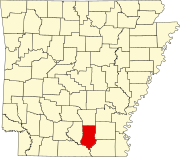
Bradley County is a county located in the U.S. state of Arkansas. As of the 2020 census, the population was 10,545. The county seat is Warren. It is Arkansas's 43rd county, formed on December 18, 1840, and named for Captain Hugh Bradley, who fought in the War of 1812.

<span class="mw-page-title-main">Ashley County, Arkansas</span> County in Arkansas, United States

Ashley County is a rural South Arkansas county with a culture, economy, and history based on timber and agriculture. Created as Arkansas's 52nd county on November 30, 1848, Ashley County has seven incorporated municipalities, including Hamburg, the county seat and Crossett, the most populous city. The county is also the site of numerous unincorporated communities and ghost towns. The county is named for Chester Ashley, a prominent lawyer in the Arkansas Territory and U.S. senator from the state from 1844 to 1848.

<span class="mw-page-title-main">Crossett, Arkansas</span> Tonia Braxton

Crossett is the largest city in Ashley County, Arkansas, United States, with a population of 5,507, according to 2010 Census Bureau estimates. Combined with North Crossett and West Crossett, the population is 10,752. Crossett was incorporated in 1903.

<span class="mw-page-title-main">North Crossett, Arkansas</span> CDP in Arkansas, United States

North Crossett is a census-designated place (CDP) in Ashley County, Arkansas, United States. Per the 2020 census, the population was 2,756.

<span class="mw-page-title-main">Bergman, Arkansas</span> Town in Arkansas, United States

Bergman is a town in Boone County, Arkansas, United States. The population was 439 at the 2010 census. It is part of the Harrison Micropolitan Statistical Area.

<span class="mw-page-title-main">South Lead Hill, Arkansas</span> Town in Arkansas, United States

South Lead Hill is a town in Boone County, Arkansas, United States. The population was 102 at the 2010 census. It is part of the Harrison Micropolitan Statistical Area.

<span class="mw-page-title-main">Valley Springs, Arkansas</span> Town in Arkansas, United States

Valley Springs is a town in Boone County, Arkansas, United States. The population was 175 at the 2010 census. It is part of the Harrison Micropolitan Statistical Area.

<span class="mw-page-title-main">Warren, Arkansas</span> City in Arkansas, United States

Warren is a city in and the county seat of Bradley County, Arkansas, United States. As of the 2010 census, the population was 6,003.

<span class="mw-page-title-main">McDougal, Arkansas</span> City in Arkansas, United States

McDougal is a city in Clay County, Arkansas, United States. The population was 186 at the 2010 census.

<span class="mw-page-title-main">Rison, Arkansas</span> City in Arkansas, United States

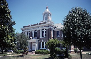
Rison, officially the City of Rison, is a city in and the county seat of Cleveland County, Arkansas, United States. Its population was 1,344 at the 2010 U.S. census. It is included in the Pine Bluff, Arkansas Metropolitan Statistical Area. Rison is a bedroom community for people who work in Pine Bluff. The largest employers are the city and county governments, the Cleveland County School District, the Cleveland County Nursing Home. There are two banks, eight churches, and about forty-five businesses within the city limits. Among the local properties listed on the National Register of Historic Places are the Rison Cities Service Station and the Rison Texaco Service Station.

<span class="mw-page-title-main">Fordyce, Arkansas</span> City in Arkansas, United States

Fordyce is a city in southeast Dallas County, Arkansas, United States. Its population has been decreasing since the 1980s when the town reached an all time high of 5,175. The population in 2020 was 3,396 down from 4,300 at the 2010 census, and from 4,799 in 2000.

<span class="mw-page-title-main">Rockport, Arkansas</span> City in Arkansas, United States

Rockport is a city in Hot Spring County in the U.S. state of Arkansas. As of the 2010 census, the population of Rockport was 755, down from 792 in 2000.

<span class="mw-page-title-main">Jacksonport, Arkansas</span> Town in Arkansas, United States

Jacksonport is a town in Jackson County, Arkansas, United States, along the White River at its confluence with the Black River. The population was 212 at the 2010 census.

<span class="mw-page-title-main">Weldon, Arkansas</span> Town in Arkansas, United States

Weldon is a town in Jackson County, Arkansas, United States. The population was 75 at the 2010 census.

<span class="mw-page-title-main">DeValls Bluff, Arkansas</span> City in Arkansas, United States

DeValls Bluff is a city in and the county seat of the southern district of Prairie County, Arkansas, United States. The population was 619 at the 2010 census.

<span class="mw-page-title-main">O'Kean, Arkansas</span> Town in Arkansas, United States

O'Kean is a town in Randolph County, Arkansas, United States. The population was 192 at the 2020 census.

<span class="mw-page-title-main">Gilbert, Arkansas</span> Town in Arkansas, United States

Gilbert is a town in Searcy County, Arkansas, United States. The population was 26 at the 2020 census, ranking it as the smallest municipality in the state and one of the smallest in the nation. Over the years, Gilbert has gained a reputation as one of the coldest locations in Arkansas.

<span class="mw-page-title-main">Georgetown, Arkansas</span> Town in Arkansas, United States

Georgetown is a town in southeastern White County, Arkansas, United States, overlooking the White River. First settled in 1789 before the Louisiana Purchase, the community is the oldest continuously settled area in Arkansas.

<span class="mw-page-title-main">Fordyce and Princeton Railroad</span>

The Fordyce and Princeton Railroad Company was a short-line railroad headquartered in Crossett, Arkansas.

Ingalls is a small community located in Bradley County, Arkansas, United States. It is about 5 miles south of Hermitage.

References

  1. "2020 U.S. Gazetteer Files". United States Census Bureau. Retrieved October 29, 2021.
  2. 1 2 U.S. Geological Survey Geographic Names Information System: Hermitage, Arkansas
  3. Local.Arkansas.gov - Hermitage , retrieved September 3, 2012
  4. "Census of Population and Housing". Census.gov. Retrieved June 4, 2015.
  5. "U.S. Census website". United States Census Bureau . Retrieved January 31, 2008.
  6. "Home". Southeast Arkansas Public Library. Retrieved May 18, 2023. - Check the hours and locations tab: "161 N. Cherry Eudora, AR 71640"
  7. | Good as gold, the timber industry celebrates a birthday at Crossett and Fordyce|Kim Harper| Journal Publishing, Inc. | Arkansas Business (Vol. 9, Issue 13)| 1992