
Newbury is a market town in the county of Berkshire, England, and is home to the administrative headquarters of West Berkshire Council. The town centre around its large market square retains a rare medieval Cloth Hall, an adjoining half timbered granary, and the 15th-century St Nicolas Church, along with 17th- and 18th-century listed buildings. As well as being home to Newbury Racecourse, it is the headquarters of Vodafone and software company Micro Focus International. In the valley of the River Kennet, 26 mi (42 km) south of Oxford, 25 mi (40 km) north of Winchester, 27 mi (43 km) southeast of Swindon and 20 mi (32 km) west of Reading.
Long Buckby is a large village and civil parish in West Northamptonshire, England. In the 2021 census the parish of Long Buckby, which includes the hamlet of Long Buckby Wharf, was recorded as having a population of 4,511.

West Berkshire is a local government district in Berkshire, England, administered from Newbury by West Berkshire Council.

High Bradfield is a rural village 6.5 miles (10 km) north-west of the centre of Sheffield in South Yorkshire, England and within the city's boundaries. The village lies just within the Peak District National Park, 1.3 miles (2 km) inside the park's north-eastern border, is at an altitude of 260 metres (850 feet) AOD, and has extensive views across Bradfield Dale towards Derwent Edge and the Dark Peak.

Aldermaston is a village and civil parish in Berkshire, England. In the 2011 census, the parish had a population of 1,015. The village is in the Kennet Valley and bounds Hampshire to the south. It is approximately 8 miles (13 km) from Newbury, Basingstoke, and Reading and is 46 miles (74 km) from London.

Lambourn is a village and civil parish in Berkshire, England. It lies just north of the M4 Motorway between Swindon and Newbury, and borders Wiltshire to the west and Oxfordshire to the north. After Newmarket it is the largest centre of racehorse training in England, and is home to a rehabilitation centre for injured jockeys, an equine hospital, and several leading jockeys and trainers. To the north of the village are the prehistoric Seven Barrows and the nearby long barrow. In 2004 the Crow Down Hoard was found close to the village.

Aldworth is a village and mainly farmland civil parish in the English county of Berkshire, near the boundary with Oxfordshire.

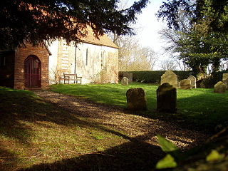
Compton is a village and civil parish in the River Pang valley in the Berkshire Downs about 6 miles (9.7 km) south of Didcot.
Winterbourne is a village and civil parish in the Berkshire Downs about 3 miles (5 km) north of Newbury in West Berkshire.

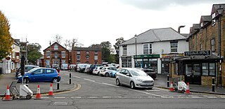
Theale is a village and civil parish in West Berkshire, England, 5 miles (8 km) southwest of Reading and 10 miles (16 km) east of Thatcham. The compact parish is bounded to the south and south-east by the Kennet & Avon Canal, to the north by a golf course, to the east by the M4 motorway and to the west by the A340 road. The village's history is a good example of how different modes of transport have achieved dominance in England over the last three centuries, from road to canal to railway and back to road again.

Hampstead Norreys is a village and civil parish in Berkshire, England. It is centred on the River Pang, north of Newbury. As well as the nucleus of Hampstead Norreys, the parish includes the hamlets of Bothampstead, Eling and Wyld Court. The village was recorded in the Domesday Book as Hanstede.
Cold Ash is a village and civil parish in West Berkshire centred 1 mile (1.6 km) from Thatcham and 2.5 miles (4 km) northeast of Newbury.

Leckhampstead is a village and civil parish in West Berkshire, England in the North Wessex Downs. A road and boundary stone in Leckhampstead, the Hangman's Stone and Hangman's Stone Lane, are named after a tale of a man who roped and carried a stolen sheep from a farm in Leckhampstead around his neck, but which strangled him after he stopped and slept. After a long hiatus the area returned to full village status in 1864. Its hamlet of Hill Green has six listed buildings and the amenities of the village include a public house, church and village hall. The associated hamlet of Leckhampstead Thicket has a high proportion of its buildings that are thatched cottages and has a Primitive Methodist chapel, dated 1874.
Hamstead Marshall is a village and civil parish in the English county of Berkshire. The village is located within the North Wessex Downs. The population of this civil parish at the 2011 census was 275.

Peasemore is a village and civil parish in the English ceremonial and historic county of Berkshire in the West Berkshire unitary authority area, west of the A34 road and north of the town of Newbury.

Chaddleworth is a village and civil parish in the English county of Berkshire.
Ashmansworth is a village and civil parish in the Basingstoke and Deane district of the English county of Hampshire.

South Moreton is a village and civil parish in South Oxfordshire, England, about 3 miles (5 km) east of Didcot, 4 miles (6.4 km) west of Wallingford, and 7 miles (11 km) south of Abingdon. It is only separated by the Great Western Railway cutting from its twin village of North Moreton, a quarter of a mile to the north. Mortune took its name in the Domesday Book from the houses on the ridge above the moor of Hakka's Brook, and was part of Berkshire until the 1974 boundary changes. The 2011 Census recorded the parish population as 420.

Mile Oak is a locality forming the northern part of the former parish of Portslade in the northwest corner of the city of Brighton and Hove, England. Now mostly residential, but originally an area of good-quality agricultural land, it covers the area north of Portslade village as far as the urban boundary.

West Hendred is a village and civil parish about 3 miles (5 km) east of Wantage. It was part of Berkshire until the 1974 boundary changes transferred it to Oxfordshire. West Hendred is downland village, its parish stretching from the Ridgeway in the south through the spring line and meadows to the former marshland of the Oxfordshire plain in the north. The parish is about 2,000 acres (810 ha) in area and 6 miles (10 km) long, but only being about 1⁄2 mile (800 m) wide at the widest point. This is an example of a downland linear parish encompassing a wide variety of land types – chalk downland, greensand on the spring line and clay to the north. The Great Western Main Line crosses the northern part of the parish. The Icknield Way and The Ridgeway cross the parish in the south.

