Hernando Beach, Florida

Last updated

History

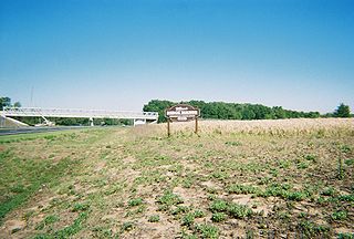
Hernando Beach [1] , situated northwest of Tampa, FL, is a picturesque waterfront canal community renowned for its natural beauty and serene atmosphere. Developed by Charlie Sasser between 1959 and 1965, the area's unique geography was shaped by earth sourced from coastal mining operations and extensive dredging efforts. The north section of Hernando Beach boasts deep and wide canals leading directly to the Gulf of Mexico, providing residents with unparalleled access to pristine waters.

Contents

Aerial Photo of the Flats in Hernando Beach Aerial Photo of the Flats in Hernando Beach.jpg
Aerial Photo of the Flats in Hernando Beach

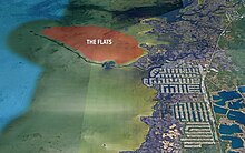
However, the area's growth faced regulatory challenges when wetland development restrictions were imposed in 1971, halting further expansion. This led to a legal dispute between Sasser, the state authorities, and the Hernando County Commission, resulting in the preservation of Hernando Beach's natural state. Despite these legal battles, Sasser's legacy lives on as visitors and residents alike continue to appreciate the area's untouched allure and breathtaking coastal flats.

Hernando Beach comprises three distinct sections, each offering unique amenities and lifestyle opportunities. The northern portion features saltwater canals ideal for boaters seeking direct Gulf access, while the middle section boasts a network of streets off Hermosa Blvd. In contrast, the southern Hernando Beach area is characterized by deed-restricted properties overseen by the Hernando Beach South Property Owners Association. For residents in the southern region, indirect Gulf access canals are navigated using a boatlift system to traverse the earthen berm separating them from the Gulf, providing a seamless connection to the direct access saltwater canals and the Gulf beyond.

Hernando Beach, Florida
Aerial view of Hernando Beach, Florida.jpg
Aerial view
Hernando County Florida Incorporated and Unincorporated areas Hernando Beach Highlighted.svg
Location in Hernando County and the state of Florida
Coordinates: 28°29′11″N82°39′28″W / 28.48639°N 82.65778°W / 28.48639; -82.65778
Country United States
State Florida
County Hernando
Area
[2]
  Total4.88 sq mi (12.64 km2)
  Land3.55 sq mi (9.19 km2)
  Water1.33 sq mi (3.45 km2)
Elevation
3 ft (1 m)
Population
 (2020)
  Total2,452
  Density691.29/sq mi (266.91/km2)
Time zone UTC-5 (Eastern (EST))
  Summer (DST) UTC-4 (EDT)
ZIP code
34607
Area code 352
FIPS code 12-29437 [3]
GNIS feature ID1867152 [4]

Hernando Beach is a census-designated place (CDP) in Hernando County, Florida, United States. The population was 2,299 at the 2010 census. [5]

Geography

The community is in southwestern Hernando County, along the Gulf of Mexico. Shoal Line Boulevard forms the eastern edge of the CDP, and the community extends from Osowaw Boulevard in the south to Minnow Creek in the north. The southern end of the CDP is 1.5 miles (2.4 km) west of U.S. Route 19 at Timber Pines; the northern end is 2.5 miles (4.0 km) southwest of the community of Weeki Wachee Gardens and 7 miles (11 km) west of U.S. Route 19 at Weeki Wachee Springs.

According to the U.S. Census Bureau, the Hernando Beach CDP has a total area of 4.1 square miles (10.5 km2), of which 3.5 square miles (9.1 km2) are land and 0.54 square miles (1.4 km2), or 13.38%, are water. [5]

Demographics

Blue Pelican Marina Blue Pelican Marina.JPG
Blue Pelican Marina
Historical population
CensusPop.Note
1990 1,767
2000 2,18523.7%
2010 2,2995.2%
2020 2,4526.7%
source: [6] [5]

As of the census [3] of 2000, there were 2,185 people, 975 households, and 727 families residing in the CDP. The population density was 558.1 inhabitants per square mile (215.5/km2). There were 1,182 housing units at an average density of 301.9 per square mile (116.6/km2). The racial makeup of the CDP was 97.71% White, 0.23% African American, 0.41% Native American, 0.55% Asian, 0.18% from other races, and 0.92% from two or more races. Hispanic or Latino of any race were 2.56% of the population.

There were 975 households, out of which 16.3% had children under the age of 18 living with them, 65.9% were married couples living together, 5.5% had a female householder with no husband present, and 25.4% were non-families. 19.5% of all households were made up of individuals, and 9.0% had someone living alone who was 65 years of age or older. The average household size was 2.24 and the average family size was 2.52.

In the CDP, the population was spread out, with 13.6% under the age of 18, 4.7% from 18 to 24, 16.7% from 25 to 44, 38.8% from 45 to 64, and 26.3% who were 65 years of age or older. The median age was 53 years. For every 100 females, there were 98.3 males. For every 100 females age 18 and over, there were 98.3 males.

The median income for a household in the CDP was $47,014, and the median income for a family was $49,605. Males had a median income of $47,093 versus $21,630 for females. The per capita income for the CDP was $25,856. About 4.2% of families and 6.6% of the population were below the poverty line, including none of those under age 18 and 10.3% of those age 65 or over.

Law enforcement

The Hernando County Sheriff's Office is in charge of law enforcement in Hernando Beach. Their Marine Unit Station headquarters is on Shoal Line Boulevard in Hernando Beach. There is also the Crime Watch in Hernando Beach, supervised by the County Sheriff's office. The United States Coast Guard Auxiliary has their Hernando County Unit, Division 15, Flotilla 8, on Shoal Line as well. Flotilla 8 is in charge of all auxiliary maritime functions for Hernando County, as well as public outreach.

The Flats

Picture of boaters in the flats in Hernando Beach in 2022 The Flats in Hernando Beach.jpg
Picture of boaters in the flats in Hernando Beach in 2022

Situated just beyond the canal system, these shallow waters offer a haven for boaters, kayakers, paddleboarders, and nature enthusiasts. Accessible via a scenic journey through the canals and marked channels, the Flats provide a peaceful escape where one can immerse themselves in the tranquil environment and bask in the sun-dappled waters. It's a favorite spot for families, offering a safe and inviting space for children to play, collect seashells, and explore the wonders of the coastal ecosystem.

Accessing the Flats in Hernando Beach [7] offers a delightful adventure for water enthusiasts, whether you opt for a boat, jet ski, or kayak. Nestled just beyond the canal system, this sandy expanse beckons with its shallow, tranquil waters. To reach this idyllic spot, navigate the canals and follow the channel markers until you reach marker 25, an easily recognizable point that marks the entrance to the Flats. You'll notice a lively scene of boaters enjoying the shallow waters, making it a popular destination throughout the year.

Map of the Flats in Hernando Beach Map of the Flats in Hernando Beach.jpg
Map of the Flats in Hernando Beach

Once you've reached the Flats, you'll discover a water depth ranging from 2 to 4 feet, varying with the tide, creating an ideal setting for activities like kayaking, paddleboarding, or simply relaxing in your boat. Many consider the Flats the highlight of Hernando Beach, drawing crowds of boaters, especially during summer weekends and holidays. It's a haven for families and children, offering opportunities to explore, collect seashells, and splash around in the inviting waters.

When navigating your boat into the Flats, especially during low tide, exercise caution as the water can become extremely shallow. Sometimes, it's easier to gently push or drag your boat into place to avoid propeller damage. Despite the popularity of the Flats, there's ample space for boaters, ensuring a stress-free and enjoyable experience without the need to rush for a spot.

See also

Related Research Articles

<span class="mw-page-title-main">Hernando County, Florida</span> County in Florida, United States

Hernando County is a county located on the west central coast of the U.S. state of Florida. As of the 2020 census, the population was 194,515. Its county seat is Brooksville, and its largest community is Spring Hill.

<span class="mw-page-title-main">Manasota Key, Florida</span> Census-designated place in Florida, United States

Manasota Key is a census-designated place (CDP) consisting mainly of the community of Englewood Beach in Charlotte County, Florida, United States. The population of the CDP was 1,326 at the 2020 census. It is part of the Sarasota-Bradenton-Punta Gorda Combined Statistical Area.

<span class="mw-page-title-main">Hernando, Florida</span> Census-designated place in Florida, US

Hernando is a census-designated place in Citrus County, Florida, United States. The population was 9,054 at the 2010 census. At one time it was a city but it was disincorporated in the 1970s.

<span class="mw-page-title-main">Lecanto, Florida</span> Census-designated place in Florida, US

Lecanto is an unincorporated community and census-designated place (CDP) in Citrus County, Florida, United States. As of the 2010 census it had a population of 5,882, up from 5,161 in 2000. It is home to several county government facilities such as the Citrus County Sheriff's Office and the Citrus Campus of the College of Central Florida.

<span class="mw-page-title-main">Bayport, Florida</span> Census-designated place in Florida, United States

Bayport is an unincorporated community and census-designated place (CDP) in Hernando County, Florida, United States. The population was 43 at the 2010 census.

<span class="mw-page-title-main">Brookridge, Florida</span> Census-designated place in Florida, United States

Brookridge is a census-designated place (CDP) in Hernando County, Florida, United States. The population was 4,420 at the 2010 census, up from 3,279 at the 2000 census.

<span class="mw-page-title-main">High Point, Hernando County, Florida</span> Census-designated place in Florida, United States

High Point is an unincorporated area and census-designated place (CDP) in Hernando County, Florida, United States. The population was 3,686 at the 2010 census.

<span class="mw-page-title-main">Istachatta, Florida</span> Census-designated place in Florida, United States

Istachatta is an unincorporated community and census-designated place (CDP) in Hernando County, Florida, United States. The population was 116 at the 2010 census, up from 65 at the 2000 census. The name "Istachatta" is derived from a Seminole word meaning "man snake".

<span class="mw-page-title-main">Nobleton, Florida</span> Census-designated place in Florida, United States

Nobleton is an unincorporated community and census-designated place (CDP) in Hernando County, Florida, United States. The population was 282 at the 2010 census, up from 160 at the 2000 census.

<span class="mw-page-title-main">North Weeki Wachee, Florida</span> Census-designated place in Florida, United States

North Weeki Wachee is a census-designated place (CDP) in Hernando County, Florida, United States. The population was 8,524 at the 2010 census, up from 4,253 at the 2000 census.

<span class="mw-page-title-main">Pine Island, Hernando County, Florida</span> Census-designated place in Florida, United States

Pine Island is an unincorporated community and census-designated place (CDP) in Hernando County, Florida, United States. The population was 64 at the 2010 census, unchanged from the 2000 census.

<span class="mw-page-title-main">Ridge Manor, Florida</span> Census-designated place in Florida, United States

Ridge Manor is a census-designated place (CDP) in Hernando County, Florida, United States. The population was 4,513 at the 2010 census.

<span class="mw-page-title-main">South Brooksville, Florida</span> Census-designated place in Florida, United States

South Brooksville is a census-designated place (CDP) in Hernando County, Florida, United States. The population was 4,007 at the 2010 census. It is a suburb included in the Tampa-St. Petersburg-Clearwater, Florida Metropolitan Statistical Area.

<span class="mw-page-title-main">Spring Hill, Florida</span> Census-designated place in Hernando County Florida, United States

Spring Hill is a census-designated place (CDP) in Hernando County, Florida, United States. The population was 113,568 at the 2020 census, up from 98,621 at the 2010 census. Spring Hill belongs to Florida's Nature Coast region and is in the Tampa-St. Petersburg-Clearwater metro area. It is east of Hernando Beach, southwest of Brooksville, and north of Tampa.

<span class="mw-page-title-main">Timber Pines, Florida</span> Census-designated place in Florida, United States

Timber Pines is a census-designated place (CDP) in Hernando County, Florida, United States. The population was 5,386 at the 2010 census.

<span class="mw-page-title-main">Weeki Wachee, Florida</span> Unincorporated community in Florida, United States

Weeki Wachee is an unincorporated community and former city located in Hernando County, Florida, United States. As of the 2020 census, the community has a total population of 16. The 12,000-acre (4,900 ha) Weeki Wachee Preserve and the Weeki Wachee Springs park are located in the area. The park includes water rides, animal shows, mermaid costume shows, and manatee watching. The communities of Weeki Wachee Gardens and Spring Hill are nearby.

<span class="mw-page-title-main">Weeki Wachee Gardens, Florida</span> Census-designated place in Florida, United States

Weeki Wachee Gardens is a census-designated place (CDP) in Hernando County, Florida, United States. The population was 1,146 at the 2010 census.

<span class="mw-page-title-main">Hudson, Florida</span> CDP in Florida, United States

Hudson is a census-designated place (CDP) located at the westernmost end of Pasco County, Florida, United States, and is included in the Tampa-St. Petersburg-Clearwater, Florida Metropolitan Statistical Area. As of the 2010 census, Hudson's population was 12,158.

<span class="mw-page-title-main">Port Mansfield, Texas</span> CDP in Texas, United States

Port Mansfield is a census-designated place (CDP) in Willacy County, Texas, United States. The population was 226 at the 2010 census.

Wiscon is an unincorporated community and census-designated place in Hernando County, Florida, United States. Its population was 681 as of the 2020 census. Florida State Road 50 passes through the community.

References

  1. "My Hernando Beach FL | Visitor Guide & Things To Do". July 22, 2021. Retrieved May 6, 2024.
  2. "2020 U.S. Gazetteer Files". United States Census Bureau. Retrieved October 31, 2021.
  3. 1 2 "U.S. Census website". United States Census Bureau . Retrieved January 31, 2008.
  4. "US Board on Geographic Names". United States Geological Survey. October 25, 2007. Retrieved January 31, 2008.
  5. 1 2 3 "Geographic Identifiers: 2010 Demographic Profile Data (G001): Hernando Beach CDP, Florida". American Factfinder. U.S. Census Bureau. Retrieved April 27, 2017.[ dead link ]
  6. "CENSUS OF POPULATION AND HOUSING (1790-2000)". U.S. Census Bureau . Retrieved July 30, 2010.
  7. "The Flats in Hernando Beach | The Complete Visitor Guide". May 17, 2023. Retrieved May 6, 2024.