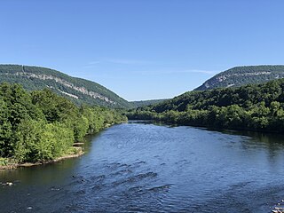
The Delaware River is a major river in the Mid-Atlantic region of the United States and is the longest free-flowing (undammed) river in the Eastern United States. From the meeting of its branches in Hancock, New York, the river flows for 282 miles (454 km) along the borders of New York, Pennsylvania, New Jersey, and Delaware, before emptying into Delaware Bay.

The East Coast of the United States, also known as the Eastern Seaboard, the Atlantic Coast, and the Atlantic Seaboard, is the region encompassing the coastline where the Eastern United States meets the Atlantic Ocean.

Sussex County is the northernmost county in the U.S. state of New Jersey. Its county seat is Newton. It is part of the New York metropolitan area and is part of New Jersey's Skylands Region. As of the 2020 census, the county was the state's 17th-most-populous county, with a population of 144,221, a decrease of 5,044 (−3.4%) from the 2010 census count of 149,265, which in turn reflected an increase of 5,099 (+3.5%) over the 144,166 persons at the 2000 census. Based on 2020 census data, Vernon Township was the county's largest in both population and area, with a population of 22,358 and covering an area of 70.59 square miles (182.8 km2). The county is part of the North Jersey region of the state.
The Mid-Atlantic is a region of the United States located in the overlap between the Northeastern and Southeastern states of the United States. The region typically includes the five states of New York, New Jersey, Pennsylvania, Delaware, and Maryland, as well as the District of Columbia, and occasionally Virginia and West Virginia. The region has its origin in the 18th century Middle Colonies of the British Empire.
The New York metropolitan area, broadly referred to as the Tri-State area and often also called Greater New York, is the largest metropolitan area in the world by urban landmass, encompassing 4,669.0 sq mi (12,093 km2). The New York metropolitan area is one of the most populous metropolitan areas in the world, the world's largest metropolitan area by size, and the only U.S. metropolitan area larger than twenty million residents as of the 2020 United States census. The vast metropolitan area includes New York City, the nation's most populous city, Long Island, the Mid- and Lower Hudson Valley in New York State; fourteen counties and eleven of the largest cities in New Jersey; and six of the seven largest cities in Connecticut. The phrase "Tri-State area" usually refers to New York / New Jersey / Connecticut, although an increasing number of people who work in New York City commute from Pennsylvania, particularly from the Lehigh Valley, Bucks County, and Poconos regions in eastern Pennsylvania. The New York metropolitan area is the geographic and demographic hub of the larger Northeast megalopolis.

The Northeastern United States, also referred to as the Northeast, the East Coast, or the American Northeast, is a geographic region of the United States located on the Atlantic coast of North America, with Canada to its north, the Southern United States to its south, and the Midwestern United States to its west. The Northeast is one of the four regions defined by the U.S. Census Bureau for the collection and analysis of statistics. The United States Census Bureau defines the region as encompassing the six New England states of Maine, New Hampshire, Vermont, Massachusetts, Rhode Island and Connecticut in addition to the three northern Mid-Atlantic states of New York, New Jersey and Pennsylvania. Some expanded definitions extend south into Maryland, Delaware, Washington, D.C., and northern parts of Virginia.
In the United States, an interstate compact is a pact or agreement between two or more states, or between states and any foreign government. The Compact Clause of the United States Constitution provides that "No State shall, without the Consent of Congress,... enter into any Agreement or Compact with another State, or with a foreign Power,..."
Tri-state area is an informal term in the United States which can refer to any of multiple areas that lie across three states. When referring to populated areas, the term implies a shared economy or culture among the area's residents, typically concentrated around a central metropolis. As a proper noun, the "Tri-State Area" often denotes the area surrounding New York City, a usage common in popular media. Other regions known as "tri-state areas" may be less urbanized and have a more diffuse population.

A borough in some U.S. states is a unit of local government or other administrative division below the level of the state. The term is currently used in six states:

New Jersey is a state within the United States of America that lies on the north eastern edge of the North American continent. It shares a land border with the state of New York along the north, ratified by both states after the New York – New Jersey Line War, which is its only straight line border. New Jersey is slightly larger than the country of Kuwait.
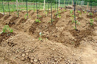
Benjamin Rush State Park is a 275-acre (111 ha) Pennsylvania state park in Philadelphia, Philadelphia County, Pennsylvania, in the United States. The park is undeveloped and is the site of community gardens, believed to be one of the largest in the world. The park is home to the Northeast Radio Controlled Airplane Club. Benjamin Rush State Park is in Northeast Philadelphia at the intersection of Southampton Road and Roosevelt Boulevard. The northern boundary of the park is formed by Poquessing Creek. There are several acres of woodlands along the creek bank. A proposal map show plans to connect the park with Fairmount Park. Other proposed improvements included hiking trails, parking facilities, and a reforestation project. The community gardens and airfield for the radio-controlled aircraft would remain.

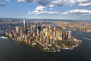
The geography of New York (state) varies widely. Most of New York is dominated by farms, forests, rivers, mountains, and lakes. New York's Adirondack Park is larger than any U.S. National Park in the contiguous United States. Niagara Falls, on the Niagara River as it flows from Lake Erie to Lake Ontario, is a popular attraction. The Hudson River begins near Lake Tear of the Clouds and flows south through the eastern part of the state without draining lakes George or Champlain. Lake George empties at its north end into Lake Champlain, whose northern end extends into Canada, where it drains into the Richelieu River and then the St. Lawrence. Four of New York City's five boroughs are on the three islands at the mouth of the Hudson River: Manhattan Island, Staten Island, and Brooklyn and Queens on Long Island.
New Jersey is a very geologically and geographically diverse region in the United States' Middle Atlantic region, offering variety from the Appalachian Mountains and the Highlands in the state's northwest, to the Atlantic Coastal Plain region that encompasses both the Pine Barrens and the Jersey Shore. The state's geological features have impacted the course of settlement, development, commerce and industry over the past four centuries.
The Farmington Valley is located along the western boundary of Hartford County in Connecticut, bordering Litchfield County immediately to the west. It is defined by the Farmington River, which runs through it. Physiographically, the valley is lowlands and floodplain flanked by the Litchfield Hills on the west and Talcott Mountain on the east.

In the United States, the forest cover by state and territory is estimated from tree-attributes using the basic statistics reported by the Forest Inventory and Analysis (FIA) program of the Forest Service. Tree volumes and weights are not directly measured in the field, but computed from other variables that can be measured.

The Ramapo Fault zone is a system of faults between the northern Appalachian Mountains and Piedmont areas to the east. Spanning more than 185 miles (298 km) in New York, New Jersey, and Pennsylvania, it is perhaps the best known fault zone in the Mid-Atlantic region, and some small earthquakes have been known to occur in its vicinity. Recently, public knowledge about the fault has increased, especially after the 1970s, when the fault's proximity to the Indian Point nuclear plant in New York was noted.
The New York City area is subject to earthquakes, but these are different in frequency and nature than on the West Coast of the US. The geology of the area has been studied and the risks to the densely populated area have been assessed.
Pyrgus centaureae wyandot, the Appalachian grizzled skipper, is a small, brown, gray and white butterfly known to inhabit parts of the Appalachian highlands and Northern Michigan. It can be identified by its characteristic checkered wing pattern formed by the scales on the fore- and hindwings. The butterflies are known to prefer sites with minimal vegetation, such as open areas in hardwood forests, as well as sites of recent disturbance. The skipper's main larval food plants include Canada cinquefoil and wild strawberry depending on the specific population's range. The butterfly is listed as a federal species of concern and holds a stated-endangered title in Ohio and New Jersey.

The New York – New Jersey Highlands is a geological formation composed primarily of Precambrian igneous and metamorphic rock running from the Delaware River near Musconetcong Mountain, northeast through the Skylands Region of New Jersey along the Bearfort Ridge and the Ramapo Mountains, Sterling Forest, Harriman and Bear Mountain State Parks in New York, to the Hudson River at Storm King Mountain. The northern region is also known as the Hudson Highlands and the southern as the New Jersey Highlands. A broader definition would extend the region west to Reading, Pennsylvania, and east to the Housatonic River in Connecticut, encompassing the Reading Prong.
