
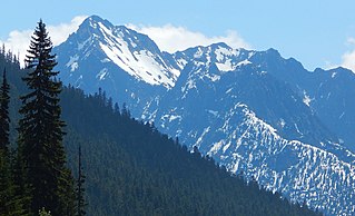
Silver Star Mountain is an 8,876-foot (2,705-metre) mountain located in Okanogan County, Washington. The mountain is part of the Methow Mountains, a subset of the Cascade Range. Silver Star is the dominant feature in the Washington Pass area and visible from the North Cascades Highway. It was first climbed by Lage Wernstedt in 1926.

Cutthroat Peak is an 8,066-foot-elevation (2,459-meter) granitic mountain located on the boundary of Chelan County and Skagit County, in Washington state. The mountain is part of the Okanagan Range which is a subrange of the Cascade Range, and it is situated within the Okanogan–Wenatchee National Forest. Cutthroat Peak is set about two miles west of Washington Pass and one mile east of Rainy Pass. It is a prominent landmark along the North Cascades Highway with an accessible climbing route. Topographic relief is significant as the summit rises over 3,000 feet above State Creek in one mile (1.6 km). There is also a Cutthroat Lake, Cutthroat Creek, and Cutthroat Pass on its north and east aspects. This landform's toponym was officially adopted in 1988 by the United States Board on Geographic Names. Molar Tooth is a granite pillar half a mile north on the ridge extending to Cutthroat Pass.

The Needles is an 8,160-foot (2,487-metre) granite mountain located in Okanogan County in Washington state. It is part of the Okanogan Range which is a sub-range of the North Cascades Range. The Needles is situated on land administered by the Okanogan–Wenatchee National Forest. Precipitation runoff from the peak drains into tributaries of the Methow River. Topographic relief is significant as the summit rises 3,660 feet above Pine Creek in approximately 1.25 mile (2 km). The nearest higher neighbor is Tower Mountain, 2.26 miles (3.64 km) to the southwest.

Gilbert Mountain is an 8,023-foot (2,445-metre) massif located in Okanogan County in Washington state. It is part of the Methow Mountains which are a subrange of the North Cascades. The mountain is situated within the Lake Chelan-Sawtooth Wilderness which is managed by Okanogan–Wenatchee National Forest. The northwestern extreme of the Gilbert massif connects to the southern end of Kangaroo Ridge. Precipitation runoff from the mountain drains into the Twisp River. Topographic relief is significant as it rises over 4,000 feet above the river in approximately one mile.

Whistler Mountain is a 7,790-foot (2,370-metre) mountain summit located in Chelan County of Washington state. The mountain is part of the Okanagan Range which is a sub-range of the North Cascades. Whistler Mountain is about two miles west of Washington Pass and one mile east of Rainy Pass. The North Cascades Highway bends around the southern base of the mountain between these two passes. A high ridge connects Whistler to its nearest higher neighbor, Cutthroat Peak, which is 0.78 miles (1.26 km) to the north-northeast. Precipitation runoff from the peak drains into Bridge Creek. Topographic relief is significant as the summit rises over 3,000 feet above the creek and highway in approximately one mile.

McKay Ridge is a 7,000+ ft ridge located in Whatcom County in Washington state. It is part of the Okanogan Range which is a sub-range of the North Cascades. It's situated north of the North Cascades Highway on land administered by the Okanogan–Wenatchee National Forest. The nearest higher peak is Majestic Mountain, 1.6 miles (2.6 km) to the northeast. Precipitation runoff from the ridge drains into Ross Lake via tributaries of the Skagit River.

Delancy Ridge is a four-mile-long ridge located in Okanogan County of Washington state. It is part of the Okanogan Range which is a sub-range of the North Cascades. Delancy Ridge is situated east of The Needles on land administered by the Okanogan–Wenatchee National Forest. Delancy Ridge can be seen from Washington Pass and from the North Cascades Highway which follows the length of its southern base. Precipitation runoff from the north side of the ridge drains into the Methow River, whereas the south side drains into Early Winters Creek which is a tributary of the Methow River. This landform's toponym was officially adopted in 1978 by the United States Board on Geographic Names.
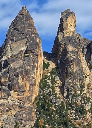
Porcupine Peak is a 7,762-foot-elevation (2,366-meter) mountain located in Skagit County of Washington state.

Blue Lake Peak is a 7,808-foot (2,380-metre) mountain summit in the North Cascades of Washington state. It is located in the Okanogan–Wenatchee National Forest on the shared border of Okanogan County and Chelan County. The peak is situated south of Early Winters Spires, Liberty Bell Mountain, and Washington Pass. Blue Lake is set below its west slope, and Stiletto Peak is to its south. Blue Lake Peak can be seen from the North Cascades Highway at the Blue Lake Trailhead. Precipitation runoff from Blue Lake Peak drains into tributaries of the Chelan River and Methow River. Topographic relief is significant as the summit rises 2,800 feet above Early Winters Creek in one mile (1.6 km). The mountain's toponym has not been officially adopted by the United States Board on Geographic Names. An alternate name, "Wamihaspi Peak," was published by mountaineer and author, Fred Beckey, in his guidebook.
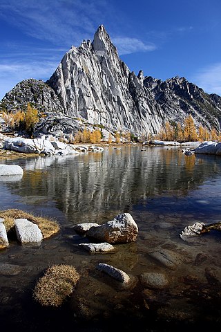
Prusik Peak is an 8000+ ft granite summit located at the west end of The Temple in Chelan County of Washington state. Prusik Peak is part of The Enchantments within the Alpine Lakes Wilderness, and is often the iconic photographic image of both areas. Prusik Peak belongs to the Stuart Range which is a subset of the Cascade Range. The name honors Dr. Karl Prusik (1896–1961) who was an Austrian mountaineer, and is known as the inventor of the prusik, a rope knot which happened to be used to gain access to the summit horn during the first ascent by Fred Beckey in 1948. Precipitation runoff drains into Icicle Creek, a tributary of the Wenatchee River.

Jabberwocky Tower is a 6,840-foot-elevation granite spire located in Chelan County of Washington state. Jabberwocky Tower is part of The Enchantments within the Alpine Lakes Wilderness. It belongs to the Stuart Range which is subset of the Cascade Range. Jabberwocky Tower is situated east of Colchuck Lake and west of Enchantment Peak. Precipitation runoff drains into Icicle Creek, a tributary of the Wenatchee River.

Crooked Bum is a 6,937-foot-elevation mountain summit on the crest of the North Cascades in the U.S. state of Washington. It is located in the Okanogan–Wenatchee National Forest on the shared border of Skagit County and Chelan County. It is situated immediately west of Rainy Pass and two miles east of Corteo Peak. The scenic and popular Maple Pass Trail traverses the south slope of the peak while staying above Lake Ann. Precipitation runoff from the north slope of Crooked Bum drains into Granite Creek which is a tributary of the Skagit River, whereas the south side drains into Bridge Creek which is a tributary of the Chelan River.

Constitution Crags is a 6,978-foot-elevation summit located in Okanogan County of Washington state. It is part of the Okanogan Range which is a sub-range of the North Cascades. Constitution Crags is situated west of Silver Star Mountain on land administered by the Okanogan–Wenatchee National Forest. The nearest higher neighbor is Hinkhouse Peak, 0.62 mile to the southwest. Washington Pass is located over a mile south of Constitution Crags, and the North Cascades Highway traverses below the east face of Constitution Crags. Like many North Cascade peaks, Constitution Crags is more notable for its large, steep rise above local terrain than for its absolute elevation. Topographic relief is significant as the summit rises nearly 2,700 feet above Early Winters Creek in approximately one mile (1.6 km). Precipitation runoff from the peak drains into Early Winters Creek which is a tributary of the Methow River.

Copper Benchmark, also known as Copper Point, is a 7,844-foot-elevation (2,391-meter) mountain summit located on the shared border between Okanogan County and Chelan County in Washington state. Copper Benchmark is part of the Methow Mountains which are a subrange of the North Cascades, and it is situated on the crest of the Cascade Range between Kangaroo Pass and Copper Pass. It was used as a triangulation station for early surveying. It is protected by the Lake Chelan-Sawtooth Wilderness within the Okanogan–Wenatchee National Forest. Copper Benchmark has a subsidiary peak, Pica Peak (elevation 7,565 feet, which is 0.52 miles northwest of the summit. The nearest higher peak is Wallaby Peak, 0.9 miles to the northeast. Precipitation runoff on the north side of the mountain drains to the Methow River via Early Winters Creek, whereas the other sides of the mountain drain into tributaries of the Chelan River.

Finney Peak is an 8,110-foot (2,470-metre) mountain summit located West of Sawtooth Ridge(The Sawtooths), a sub-range of the North Cascades in Chelan County of Washington state. Finney Peak is situated within the Lake Chelan-Sawtooth Wilderness on land managed by the Okanogan–Wenatchee National Forest. The nearest higher peak is Star Peak, 3 miles (4.8 km) to the northeast. Precipitation runoff from the mountain drains into nearby Lake Chelan via Prince Creek and Cascade Creek.

Jim Hill Mountain is a prominent 6,765 ft (2,060 m) mountain summit located in Chelan County of Washington state. Jim Hill Mountain is situated 3.5 mi (5.6 km) east of Stevens Pass, on the boundary of Alpine Lakes Wilderness, on land managed by the Okanogan–Wenatchee National Forest. Jim Hill Mountain is part of the Chiwaukum Mountains, which are a subset of the Cascade Range. Its nearest higher neighbor is Bulls Tooth, 3.8 mi (6.1 km) to the south. Precipitation runoff from the peak drains into tributaries of Nason Creek, which in turn is a tributary of the Wenatchee River. Jim Hill Mountain is set immediately south of the east portal of the Cascade Tunnel, which was built by the Great Northern Railway. This mountain was named by Albert Hale Sylvester to honor James J. Hill (1838–1916), the chief executive officer of the Great Northern Railway. Hill became known during his lifetime as "The Empire Builder", a name bestowed to the Empire Builder passenger train that runs from Seattle to Chicago, and traverses below this mountain.

Arrowhead Mountain is a 6,030 ft (1,840 m) mountain summit located in Chelan County of Washington state. It is situated 6 mi (9.7 km) east of Stevens Pass, on the boundary of Alpine Lakes Wilderness, on land managed by the Okanogan–Wenatchee National Forest. Arrowhead Mountain is part of the Chiwaukum Mountains, which are a subset of the Cascade Range. Its nearest higher neighbor is Jim Hill Mountain, 2.5 mi (4.0 km) to the southwest. Precipitation runoff from the peak drains into tributaries of Nason Creek, which in turn is a tributary of the Wenatchee River. This mountain was named by Albert Hale Sylvester (1871–1944), a pioneering surveyor, explorer, topographer, and forest supervisor who named hundreds of natural features in the Cascades.
Hock Mountain is a 7,750-foot-elevation summit located in the Methow Mountains which are a subset of the North Cascades in Washington state. It is situated on the triple-shared boundary of North Cascades National Park, Lake Chelan-Sawtooth Wilderness, and Lake Chelan National Recreation Area, as well as the shared border between Chelan County and Okanogan County. Additionally, it lies one mile southwest of Twisp Mountain, and 2.24 miles (3.60 km) due south of Stiletto Peak, the nearest higher neighbor. The north face is steep, granitic rock, but the west slope is more moderate, allowing a scramble ascent. Precipitation runoff from the north and west sides of Hock drains to the Stehekin River via Bridge Creek, whereas the south and east sides of the mountain drain into the South Fork Twisp River.
Mother Lode is a 7,905-foot-elevation (2,409-meter) mountain summit located in the North Cascades, in Okanogan County, Washington. It is situated in the Lake Chelan-Sawtooth Wilderness, on land managed by Okanogan–Wenatchee National Forest. The mountain is part of the Methow Mountains, which are a subset of the Cascade Range, and the peak is approximately two miles east of the crest of the range. Mother Lode is set approximately six miles south of Washington Pass, and the nearest higher neighbor is Gilbert Mountain, three miles to the northeast. Topographic relief is significant as the north aspect rises 3,500 feet above the South Fork Twisp River in one mile. The peak was climbed in 1983 by Rick La Belle and Glen Sterr via the north ridge, and the northeast ridge was climbed in 1985 by Carl and Gordon Skoog. Precipitation runoff from the peak drains into tributaries of Twisp River, which in turn is a tributary of the Methow River.
Lexington Tower is a 7,560-foot-elevation (2,300-meter) granite pinnacle located in the North Cascades, approximately one mile south of Washington Pass along the North Cascades Highway. It is set within the Okanogan–Wenatchee National Forest, on the shared border of Okanogan County and Chelan County in the state of Washington. Lexington Tower is part of the iconic Liberty Bell Group, a group of spires which also includes Liberty Bell Mountain, Concord Tower, and the Early Winters Spires. Precipitation runoff from Lexington Tower drains west into State Creek and east into Early Winters Creek. Topographic relief is significant as the summit rises 2,500 feet above Early Winters Creek in approximately one-half mile.


