Historical buildings and structures of Zion National Park

Last updated
Multiple Resources for Zion National Park
Zion National Park east entrance sign-20070724.jpg
East Entrance Sign
USA Utah location map.svg
Red pog.svg
Usa edcp location map.svg
Red pog.svg
Coordinates 37°14′7″N112°52′7″W / 37.23528°N 112.86861°W / 37.23528; -112.86861 (General location of Zion National Park) Coordinates: 37°14′7″N112°52′7″W / 37.23528°N 112.86861°W / 37.23528; -112.86861 (General location of Zion National Park)
Architectural style NPS-Rustic style
MPS Zion National Park MRA
NRHP reference No. 64000878 [1]
Map all coordinates using: OpenStreetMap  
Download coordinates as: KML

The historical buildings and structures of Zion National Park represent a variety of buildings, interpretive structures, signs and infrastructure associated with the National Park Service's operations in Zion National Park, Utah. Structures vary in size and scale from the Zion Lodge to road culverts and curbs, nearly all of which were designed using native materials and regional construction techniques in an adapted version of the National Park Service Rustic style. A number of the larger structures were designed by Gilbert Stanley Underwood, while many of the smaller structures were designed or coordinated with the National Park Service Branch of Plans and Designs. The bulk of the historic structures date to the 1920s and 1930s. Most of the structures of the 1930s were built using Civilian Conservation Corps labor.

Contents

The version of the National Park Service Rustic style that was adopted at Zion was less extreme in its rustic character than that employed at other parks. Compared with the Bryce Canyon Lodge, the Zion Park Lodge used smaller elements of timber and stonework, and employed milled lumber in place of rough log elements. This reflected the more settled character of the Zion area, which retained farms and irrigation systems at the time the first visitor facilities were built. [1]

Many of Zion's historical structures are listed on the National Register of Historic Places (NRHP), either as individual structures or as contributing structures in a historic district. [1] They represent an unusually homogeneous series of buildings for a national park, sharing details of composition, scale and materials. They have collectively been described as some the best work in the National Park Service Rustic style. [2] (The NRHP-listed structures are also listed in alphabetical order in National Register of Historic Places listings in Zion National Park.)

The park also preserves remnants of early Mormon settlement in Zion Canyon, which began in 1862. Two irrigation canals and a cable draw works remain. [1]

Utah Parks Company

Zion Nature Center - Zion Inn Zion Nature Center renovated.jpg
Zion Nature Center - Zion Inn

Transportation and infrastructure

Historic American Engineering Record drawing, Cable Creek Bridge Cable Creek Bridge 1.png
Historic American Engineering Record drawing, Cable Creek Bridge
South Entrance Sign South Entrance Sign.jpg
South Entrance Sign

Park Service facilities

Employee and service facilities

Museum-Grotto Residence Zion National Park, Zion Museum, Springdale vicinity (Washington, Utah).jpg
Museum-Grotto Residence
East Entrance Residence East Ranger House.jpg
East Entrance Residence

Trails

Angels Landing Trail Angels Landing in Zion National Park (May 2007).jpg
Angels Landing Trail
Hidden Canyon Trail Hidden Canyon trail zion national park.jpg
Hidden Canyon Trail

Archeological sites

The West Rim Trail follows along the rim with views of Phantom valley and the canyons to the south.

Other historic places

The chief remaining structure is a wood headframe on Cable Mountain. The structures at the bottom of the cables consisted of snubbing posts to separate the cables. Nothing remains of the lower end of the draw works. [29]

See also

Related Research Articles

<span class="mw-page-title-main">The Narrows (Zion National Park)</span> Narrowest part of Zion Canyon in Zion National Park, Utah

The Narrows is the narrowest section of Zion Canyon in Zion National Park, Utah, United States. Situated on the North Fork of the Virgin River and upstream of the main canyon, The Narrows is one of the premier hikes in the park and on the Colorado Plateau. The Narrows refers to both the 3.6-mile (5.8 km) bottom-up hike from the Temple of Sinawava to Big Springs, as well as the 16-mile (26 km) top-down hike from Chamberlain's Ranch back to the Temple of Sinawava.

<span class="mw-page-title-main">Zion Lodge</span> United States historic place

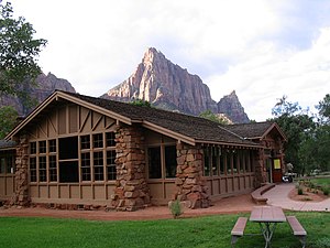
Zion Lodge is located in Zion National Park, Utah, United States. The lodge was designed in 1924 as a compromise solution between its developer, the Utah Parks Company, which wanted a large hotel, and National Park Service director Stephen Mather, who desired smaller-scale development. The Utah Parks Company had been formed in 1923 as a subsidiary of the Union Pacific Railroad, and was, like many similar programs, intended to stimulate passenger rail traffic to the national parks of southwest Utah.

<span class="mw-page-title-main">Angels Landing</span>

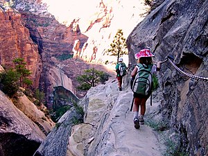
Angels Landing, known previously as the Temple of Aeolus, is a 1,488-foot (454 m) tall rock formation in Zion National Park in southwestern Utah, United States. A renowned trail cut into solid rock in 1926 leads to the top of Angels Landing and provides panoramic views of Zion Canyon.

<span class="mw-page-title-main">Bryce Canyon Lodge</span> United States historic place

Bryce Canyon Lodge is a lodging facility in Bryce Canyon National Park, Utah, United States, built between 1924 and 1925 using local materials. Designed by architect Gilbert Stanley Underwood, the lodge is an excellent example of National Park Service rustic design, and the only remaining completely original structure that Underwood designed for Bryce Canyon National Park, Zion National Park, and the North Rim of the Grand Canyon.

<span class="mw-page-title-main">Grand Canyon Lodge</span> NRPH building in Coconino County, Arizona

The Grand Canyon Lodge is a hotel and cabins complex at Bright Angel Point on the North Rim of the Grand Canyon. It was designed by Gilbert Stanley Underwood, who designed a number of other hotels in national parks for the Utah Parks Company and other concessioners. Built in 1927–28, the Grand Canyon Lodge resort complex consists of the Main Lodge building, 23 deluxe cabins, and 91 standard cabins, some of which were moved to the north rim campground in 1940. All guests are housed in cabins detached from the main lodge, which serves as a dining, concessions and service facility. Constructed of native Kaibab limestone and timber, the complex was designed to harmonize with its rocky and forested setting. The Grand Canyon Lodge complex is notable for its setting and rustic design, as well as its status as the only complete surviving lodge and cabin complex in the national parks.

<span class="mw-page-title-main">Grand Canyon Village Historic District</span> Historic district in Arizona, United States

Grand Canyon Village Historic District comprises the historic center of Grand Canyon Village, on the South Rim of the Grand Canyon in Grand Canyon National Park, Arizona. The district includes numerous landmark park structures, many of which are National Historic Landmarks themselves, or are listed on the National Register of Historic Places. The town design as a whole is also significant for its attention to integration with the Grand Canyon landscape, its incorporation of National Park Service Rustic design elements, and for the idiosyncratic design of park concessioner structures such as the El Tovar Hotel.

<span class="mw-page-title-main">Zion National Park</span> National park in Utah, United States

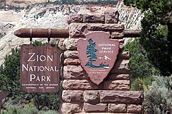
Zion National Park is an American national park located in southwestern Utah near the town of Springdale. Located at the junction of the Colorado Plateau, Great Basin, and Mojave Desert regions, the park has a unique geography and a variety of life zones that allow for unusual plant and animal diversity. Numerous plant species as well as 289 species of birds, 75 mammals, and 32 reptiles inhabit the park's four life zones: desert, riparian, woodland, and coniferous forest. Zion National Park includes mountains, canyons, buttes, mesas, monoliths, rivers, slot canyons, and natural arches. The lowest point in the park is 3,666 ft (1,117 m) at Coalpits Wash and the highest peak is 8,726 ft (2,660 m) at Horse Ranch Mountain. A prominent feature of the 229-square-mile (590 km2) park is Zion Canyon, which is 15 miles (24 km) long and up to 2,640 ft (800 m) deep. The canyon walls are reddish and tan-colored Navajo Sandstone eroded by the North Fork of the Virgin River.

<span class="mw-page-title-main">Roes Creek Campground Camptender's Cabin</span> Cabin in Glacier National Park, an example of the National Park Service Rustic style

The Roes Creek Campground Camptender's Cabin, also known as the Rising Sun Campground Ranger Cabin, in Glacier National Park is an example of the National Park Service Rustic style.

<span class="mw-page-title-main">Many Glacier Barn and Bunkhouse</span> United States historic place

The Many Glacier Barn and Bunkhouse in Glacier National Park, also known as Packer's Roost East, were constructed to serve backcountry pack trail activities near the Many Glacier Hotel. The barn was designed in 1938 by the National Park Service Branch of Plans and Design to replace a barn that had burned in the Swiftcurrent Valley fire of 1936, using a simplified form of the National Park Service Rustic style. The bunkhouse was built nearby, then moved directly adjacent to the barn.

<span class="mw-page-title-main">Generals' Highway Stone Bridges</span> United States historic place

The Generals' Highway Stone Bridges, built in 1930, are part of the Generals' Highway from the General Grant Grove of giant sequoias in Kings Canyon National Park through Sequoia National Park. One bridge spans the Marble Fork of the Kaweah River in a wooded setting, while the other, similar bridge spans Clover Creek in a bare canyon.

<span class="mw-page-title-main">Timber Creek Campground Comfort Stations</span> United States historic place

The Timber Creek Campground Comfort Stations are a set of three historic public toilet facilities in Rocky Mountain National Park. Designed in 1935 by landscape architect Howard W. Baker of the National Park Service Branch of Plans and Designs, the National Park Service Rustic buildings were built with Civilian Conservation Corps labor in 1939. They were added to the National Register of Historic Places on January 29, 1988.

<span class="mw-page-title-main">Floor of the Valley Road</span> United States historic place

The Floor of the Valley Road, also known as the Zion Canyon Scenic Drive, follows the canyon of the North Fork of the Virgin River, also known as Zion Canyon, through Zion National Park, Utah, USA. A precursor to the present nine-mile road was first built in 1916, but was later redesigned by the National Park Service Branch of Plans and Designs to highlight the natural features of the valley while presenting a natural-appearing built environment. The road begins at the south boundary of the park and ends at the Temple of Sinawava.

<span class="mw-page-title-main">Zion – Mount Carmel Highway</span> United States historic place

The Zion – Mount Carmel Highway is a 25-mile (40 km) long road in Washington and Kane counties in southern Utah, United States, that is listed on the National Register of Historic Places and is a National Historic Civil Engineering Landmark.

<span class="mw-page-title-main">Zion Lodge Historic District</span> Historic district in Utah, United States

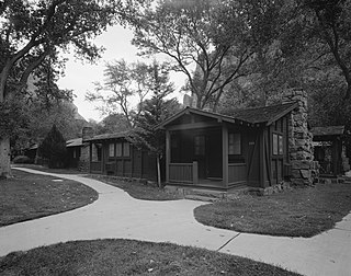
The Zion Lodge Historic District surrounds the rustic lodge originally designed by Gilbert Stanley Underwood in Zion National Park. The lodge served as the center of a group of cabins, employee dormitories and support buildings which are included in the district. A swimming pool and bathhouse were demolished in 1976. The district was expanded in 1986 to include an Underwood-designed former photography studio and additional cabins.

<span class="mw-page-title-main">Wonderland Trail Shelters</span> United States historic place

The Wonderland Trail is an approximately 93-mile (150 km) hiking trail that circumnavigates Mount Rainier in Mount Rainier National Park, Washington, United States. The trail goes over many ridges of Mount Rainier for a cumulative 22,000 feet (6,700 m) of elevation gain. The trail was built in 1915.

<span class="mw-page-title-main">Grand Canyon Inn and Campground</span> United States historic place

The Grand Canyon Inn and Campground, also known as the North Rim Inn, were built by the William W. Wylie and the Utah Parks Company as inexpensive tourist accommodations on the North Rim of the Grand Canyon, in Grand Canyon National Park. Intended to complement the more expensive Grand Canyon Lodge, the cabins and Inn were located near Bright Angel Point, but father back than their more expensive counterparts, near the Grand Canyon North Rim Headquarters. The design of the cabins and the redesign of the Inn building were undertaken by architect Gilbert Stanley Underwood.

Architects of the National Park Service are the architects and landscape architects who were employed by the National Park Service (NPS) starting in 1918 to design buildings, structures, roads, trails and other features in the United States National Parks. Many of their works are listed on the National Register of Historic Places, and a number have also been designated as National Historic Landmarks.

Harry Langley was an architect of the National Park Service. He was born in England. He retired in 1957.

<span class="mw-page-title-main">The Watchman (Utah)</span>

The Watchman is a 6,545-foot (1,995 m) sandstone mountain summit located in Zion National Park, in Washington County of southwest Utah, United States.

<span class="mw-page-title-main">Cable Mountain</span>

Cable Mountain is a 6,940-foot (2,120 m) elevation Navajo Sandstone summit located in Zion National Park, in Washington County of southwest Utah, United States. Towering 2,600 feet above the floor of Zion Canyon at the Big Bend area, Cable Mountain is situated immediately northeast of The Great White Throne, separated by the chasm of Hidden Canyon. It is set on the east side of the North Fork Virgin River which drains precipitation runoff from this mountain. Its neighbors include Angels Landing, Cathedral Mountain, The Organ, and Observation Point. This mountain's name was officially adopted in 1934 by the U.S. Board on Geographic Names. It is so named in association with the draw-works which used cables to lower timber from the top of the plateau down to the valley bottom from 1901 through 1927. Wood to construct the Zion Lodge came down the cable works. A 7.4-mile trail, much of it an old wagon road, leads to the views from the top.

References

  1. 1 2 3 4 5 6 7 8 9 10 11 Jurale, Jim; Witherall, Nancy (1984). "National Register of Historic Places Inventory - Nomination Form: Multiple Resources for Zion National Park". National Park Service. Retrieved 2009-09-03.
  2. Kaiser, Harvey H. (2008). The National Park Architecture Sourcebook. Princeton Architectural Press. pp.  163. ISBN   978-1-56898-742-2.
  3. Kaiser, Harvey H. (2008). The National Park Architecture Sourcebook. Princeton Architectural Press. pp.  162. ISBN   978-1-56898-742-2.
  4. Culpin, Mary Shivers (January 12, 1982). "National Register of Historic Places Inventory - Nomination Form: Zion Lodge Historic District". National Park Service. Retrieved 2009-06-19.
  5. 1 2 3 4 5 6 7 8 9 10 11 12 13 14 15 16 17 18 19 20 21 22 23 24 25 "National Register Information System". National Register of Historic Places . National Park Service. March 13, 2009.
  6. Witherell, Nancy (October 10, 1984). "List of Classified Structures: Zion Nature Center/Zion Inn". National Park Service. Retrieved 2009-06-19.
  7. Sontag, Robert (July 27, 1995). "National Register of Historic Places Inventory-Nomination: Cable Creek Bridge" (pdf). National Park Service.{{cite journal}}: Cite journal requires |journal= (help)
  8. Culbertson, Laura J.; Croteau, Todd A. (1993). "Zion-Mount Carmel Highway Tunnel 1930". Historic American Engineering Record. p. 1. Retrieved 2009-06-19.
  9. Witherell, Nancy (October 10, 1984). "Classified Structure Inventory: East Entrance Checking Station" (pdf). National Park Service.{{cite journal}}: Cite journal requires |journal= (help)
  10. Witherell, Nancy (October 10, 1984). "Classified Structure Inventory: East Entrance Sign". National Park Service.{{cite journal}}: Cite journal requires |journal= (help)
  11. "East Entrance Sign". List of Classified Structures. National Park Service. Retrieved 2009-03-04.
  12. "Zion National Park, Entrance Sign (1936)". Parkitecture in the Western Parks. National Park Service. 2009-09-02.
  13. Witherell, Nancy (October 10, 1984). "Classified Structure Inventory: Grotto Picnic Area Comfort Station (No. 129)". National Park Service.{{cite journal}}: Cite journal requires |journal= (help)
  14. Witherell, Nancy (October 10, 1984). "Classified Structure Inventory: Grotto Picnic Area Comfort Station (No. 130)". National Park Service.{{cite journal}}: Cite journal requires |journal= (help)
  15. Witherell, Nancy (October 10, 1984). "Classified Structure Inventory: South Campground Comfort Station (No. 131)". National Park Service.{{cite journal}}: Cite journal requires |journal= (help)
  16. Witherell, Nancy (October 10, 1984). "Classified Structure Field Inventory Report: South Campground Amphitheater". National Park Service. Retrieved 2009-09-09.
  17. "National Register Information System". National Register of Historic Places . National Park Service. April 15, 2008.
  18. Witherall, Nancy (October 10, 1984). "Classified Struicture Field Inventory: Grotto Residence". National Park Service. Retrieved 2009-09-08.
  19. Nancy Witherell (October 10, 1984). "Classified Structure Inventory: East Entrance Residence" (pdf). National Park Service.{{cite journal}}: Cite journal requires |journal= (help)
  20. Jurale, James (July 6, 1984). "Classified Structure Field Inventory: Pine Creek Residential Historic District". National Park Service. Retrieved 2009-10-09.
  21. Jurale, James (September 12, 1984). "Classified Structure Field Inventory Report: Canyon Overlook Trail". National Park Service. Retrieved 2009-09-10.
  22. Jurale, James (September 5, 1984). "Classified Structure Field Inventory Report: East Rim Trail". National Park Service. Retrieved 2009-09-10.
  23. Annie, Hartman (12 July 2018). "Angels Landing Is One of the Most Dangerous Hikes in the US". Curiosity: Amazing Places. curiosity.com. Retrieved 23 August 2018.
  24. Jurale, James (September 14, 1984). "Classified Structure Field Inventory Reports: Angels Landing Trail and West Rim Trail". National Park Service. Retrieved 2009-09-09.
  25. Jurale (September 6, 1984). "Classified Structure Inventory: Emerald Pools Trail" (pdf). National Park Service.{{cite journal}}: Cite journal requires |journal= (help)
  26. 1 2 3 James Jurals (September 6, 1984). "Classified Structure Inventory: Gateway to the Narrows" (pdf). National Park Service.{{cite journal}}: Cite journal requires |journal= (help)
  27. Jurale, James (September 6, 1984). "Classified Structure Field Inventory Report: Hidden Canyon Trail". National Park Service. Retrieved 2009-09-08.
  28. "Parunuweap Canyon Prehistoric Structure". List of Classified Structures. National Park Service. Archived from the original on 2012-06-01. Retrieved 2009-03-02.
  29. 1 2 3 Parkinson, Charles R. (September 1977) [January 1972]. "National Register of Historic Places Inventory - Nomination Form: Cable Mountain Draw Works". National Park Service. Retrieved 2009-09-04.
  30. Jurale, James. "Classified Structure Field Inventory Report: Pine Creek Irrigation Canal". National Park Service. Retrieved 2009-09-04.
  31. Jurale, James (September 29, 1984). "Classified Structure Field Inventory: Oak Creek Irrigation Canal". National Park Service. Retrieved 2009-09-08.
  32. Kardas, Susan; Larrabee, Edward (April 1997). "National Register of Historic Places Continuation Sheet: Flanigan Ditch, Zion National Park MRA (addendum)". National Park Service. Retrieved 2009-09-09.
Map all coordinates using: OpenStreetMap  
Download coordinates as: KML

National Register of Historic Places photographs

HABS/HAER Documentation

The Historic American Buildings Survey (HABS) and the Historic American Engineering Record (HAER) have extensive documentation of park structures. A selection is provided below.