History of 19th-century congressional redistricting in Ohio
Last updated
The redistricting of United States congressional districts is made by the legislatures of the states every 10 years, immediately following the official announcement of the federal census that serves as the basis of the apportionment. It was long the practice that the apportionment thus made stood until after the next decennial census.
However, the power rests with the legislature to change or adjust the apportionment during the interim and in 1845, the tradition in Ohio of reapportioning following the decennial census was broken. For the last half of the century, it was the policy of the party in power in the legislature to secure the largest amount of political advantage in making the apportionments, and they were made whenever the political control of the assembly changed. From 1878 to 1892, the state was reapportioned six times as power oscillated between the two parties.
A partisan majority in the legislature has it in their power to so apportion the districts as to enable the minority of the voters in the state to elect a majority of the congressional delegation, or to empower a bare majority of the voters to elect almost the entire delegation, in effect disenfranchising the minority. No apportionment of Ohio was absolutely free from partisan bias.
Constitutional background
Ohio’s legislative structure
Under the original Ohio constitution, state representatives were chosen annually for the term of one year, and state senators were chosen for two years, the original allotment being such that half the senators held over and one-half of the body was chosen at the annual elections, necessitating annual sessions of the legislature.
The mode of electing members of the Ohio General Assembly was changed under the constitution of 1851. Senators and representatives were elected biennially, for the term of two years, and the entire legislature changed its membership at the end of the biennial period.
The object of the change in the organic law was to obviate annual legislative sessions, but as a rule, up to the last decade of the century, annual sessions were held, the general assembly adjourning to a date in the second year of the biennial period to complete its unfinished business and consider other legislative matters.
Other changes were proposed in the Ohio Constitutional Convention of 1872–73. However, the citizens soundly rejected the proposed changes in the referendum in 1874. The next change in the state constitution did not occur until the 20th century.
Ohio’s county structure
At the time of the first apportionment in 1812, there were 40 organized counties in the state. During each of the following decennial periods up to 1851, new counties were created to the current number of 88. Where portions of the new counties came from two or more congressional districts, the voters continued to cast their ballots for representative in Congress as in the original district until the next apportionment was made.
Ohio entered the Union on February 19, 1803 a few weeks before the end of the Seventh Congress. From 1803 to 1812, the entire state constituted a single representative district in Congress, held by Jeremiah Morrow for all five terms. In the Seventh Congress Ohio had a population of 47,500; in the Eighth, when the state was first fully represented, the population was 68,850; in the Ninth the population numbered 91,280; in the Tenth it rose to 150,965, and in the Eleventh it reached 250,325, so that the member from Ohio not only represented the largest geographical territory of any single congressman, but about three times as large a constituency as any other.
First apportionment — 1812 to 1822
The state was first apportioned into representative districts by the Act of January 14, 1812, six districts being designated.
Based on the Third Federal Census, the state was entitled to seven representatives in Congress[citation needed], but this fact was overlooked at the time the apportionment was made. No attempt was made to rectify this error, the result being that Ohio was short five congressional seats during the decade, and one elector at each of the presidential elections in 1812, 1816 and 1820.
The second apportionment was made on 22 May 1822. The official report of the Fourth Federal Census not having been received in time for consideration and action at the regular session, the state legislature was assembled in extraordinary session for that purpose. The state then contained 66 organized counties, and was divided into 14 districts.
On 4 June 1832, the legislature convened in extraordinary session for the second time for the purpose of apportioning the state into congressional districts and continued in session 10 days to complete the apportionment.
There were 74 organized counties and they were divided into 19 districts based on the Fifth Federal Census.
The fourth apportionment for Congress was made at the fourth extraordinary session of the legislature, convened for the purpose on 25 July 1842. The legislature in 1842 contained a Democratic majority and the apportionment debate acrimonious, the Whigs denouncing the proposed redistricting as unfair and grossly partisan. Consequently, the session ran until August 12.
This adjustment of the congressional districts subsequently became the excuse for a number of the most notorious gerrymanders at the hands of the leaders of both parties in later years.
There were 78 organized counties, which were divided into 21 districts based on the Sixth Federal Census.
The legislature in 1842 had a Democratic majority and the apportionment had been denounced by the Whigs as unfair and grossly partisan. In 1844–1845, control of the legislature was in Whig hands. On 12 March 1845, the Whigs proceeded to readjust the congressional districts, the first use of the implied legislative power to redistrict at any time, not bound strictly to the federal census. The legislature added one county to the list of those already organized.
On the 11 March 1851, the eighty-eighth county was organized; no additional county has been created since then. The legislature of 1852–1853, the first elected under the new Ohio constitution, was Democratic and apportioned the state into 21 congressional districts under the Seventh Federal Census.
The legislature elected in 1861 and serving during 1862 and 1863 was controlled by the Republican Party. The United States Congress had just passed an act increasing the ratio of representation, and this had the effect of reducing the number of Ohio representatives in Congress from 21 to 19, and in the rest of the Union proportionately. During the first session of the Fifty-fifth general assembly, in 1862, the state was apportioned into the 19 districts based on the Eighth Federal Census.
Ohio congressional districts 1862–1872
District
Counties
First
Hamilton (a part of).
Second
Hamilton (a part of).
Third
Montgomery, Preble, Butler, Warren.
Fourth
Darke, Shelby, Logan, Champaign, Miami.
Fifth
Van Wert, Mercer, Allen, Auglaize, Hardin, Hancock, Wyandot.
In the seventh decennial period, Ohio regained a congressman and was entitled to 20 representatives. The legislature chosen in 1871, and sitting in 1872–1873 was controlled by the Republican Party, and during the session of 1872 apportioned the state into twenty districts based on the Ninth Federal Census.
Ohio congressional districts 1872–1878
District
Counties
First
Hamilton (a part of).
Second
Hamilton (a part of).
Third
Butler, Warren, Clinton, Fayette, Clermont.
Fourth
Darke, Preble, Montgomery, Greene.
Fifth
Defiance, Paulding, Putnam, Van Wert, Allen, Auglaize, Mercer, Shelby.
Sixth
Williams, Fulton, Henry, Wood, Lucas, Ottawa.
Seventh
Highland, Brown, Adams, Pike, Ross.
Eighth
Clark, Madison, Miami, Logan, Champaign.
Ninth
Hardin, Marion, Delaware, Union, Morrow, Knox.
Tenth
Hancock, Seneca, Sandusky, Erie, Huron.
Eleventh
Hocking, Vinton, Jackson, Scioto, Lawrence, Gallia.
Twelfth
Franklin, Pickaway, Fairfield, Perry.
Thirteenth
Licking, Muskingum, Coshocton, Tuscarawas.
Fourteenth
Wyandot, Crawford, Richland, Ashland, Holmes.
Fifteenth
Meigs, Athens, Morgan, Monroe, Washington.
Sixteenth
Jefferson, Harrison, Belmont, Noble, Guernsey.
Seventeenth
Carroll, Stark, Columbiana, Mahoning.
Eighteenth
Lorain, Medina, Wayne, Summit.
Nineteenth
Ashtabula, Trumbull, Geauga, Lake, Portage.
Twentieth
Cuyahoga.
Ninth apportionment — 1878 to 1880
The Sixty-third general assembly, elected in 1877, was controlled by the Democratic Party, and following the precedent of the Whig legislature of 1845, at its session in 1878 it revised and recast the representative districts.
The result of this readjustment of the districts was seen at the ensuing election. At the election in 1878, the head of the Republican state ticket received 274,120 votes, and the head of the Democratic ticket received 270,966 votes. Each party won ten seats. In contrast, using the earlier districting two years before in 1876, the heads of the tickets were similarly balanced (Republican 317,856, Democratic 311,220), yet voters elected 13 Republican congressmen and 7 Democrats.
Ohio congressional districts 1878–1880
District
Counties
First
Hamilton (a part of).
Second
Hamilton (a part of).
Third
Montgomery, Butler, Warren.
Fourth
Greene, Clark, Champaign, Logan, Union.
Fifth
Preble, Darke, Miami, Shelby, Auglaize, Mercer.
Sixth
Van Wert, Allen, Putnam, Paulding, Williams, Henry, Fulton.
A Republican legislature was elected in 1879, and sat in 1880–1881. It proceeded at its first session to redistrict the state, and its effect upon the political campaign of the congressional delegation was pronounced. The vote for the head of the ticket was: Republican, 362,021; Democratic, 343,016. Instead of 10 members to each of the parties as in the election of 1878, the Republicans secured 14 and the Democrats 6.
Ohio congressional districts 1880–1882
District
Counties
First
Hamilton (a part of),
Second
Hamilton (a part of),
Third
Butler, Warren, Clinton, Fayette
Fourth
Darke, Preble, Montgomery, Greene.
Fifth
Defiance, Paulding, Putnam, Van Wert, Allen, Auglaize, Mercer, Shelby.
Sixth
Fulton, Henry, Wood, Lucas, Ottawa, Williams.
Seventh
Highland, Brown, Adams, Pike
Eighth
Clark, Madison, Miami, Logan, Champaign.
Ninth
Hardin, Marion, Union, Knox, Delaware, Morrow.
Tenth
Hancock, Seneca, Erie, Huron, Sandusky.
Eleventh
Hocking, Vinton, Jackson, Scioto, Lawrence, Gallia.
Twelfth
Franklin, Pickaway, Fairfield, Perry
Thirteenth
Licking, Muskingum, Coshocton, Tuscarawas.
Fourteenth
Wyandot, Crawford, Richland, Holmes, Ashland.
Fifteenth
Meigs, Athens, Morgan, Monroe, Washington.
Sixteenth
Jefferson, Harrison, Belmont, Noble, Guernsey.
Seventeenth
Carroll, Stark, Columbiana, Mahoning.
Eighteenth
Lorain, Medina, Wayne, Summit.
Nineteenth
Trumbull, Portage, Geauga, Lake, Ashtabula.
Twentieth
Cuyahoga.
Eleventh apportionment — 1882 to 1884
With the beginning of the eighth decennial period, Ohio was entitled to an additional representative in congress following the Tenth Federal Census, and there were 21 districts to be created. The legislature elected in 1882, and which met in 1883, was controlled by the Republican Party.
Ohio congressional districts 1882–1884
District
Counties
First
Hamilton (a part of).
Second
Hamilton (a part of).
Third
Preble, Montgomery, Miami.
Fourth
Darke, Shelby, Mercer, Auglaize.
Fifth
Putnam, Hancock, Wyandot, Seneca, Crawford.
Sixth
Wood, Fulton, Williams, Henry, Defiance, Paulding, Van Wert.
The Sixty-sixth general assembly, 1884–1885, elected in 1883, was Democratic. However, reapportionment by the Democrats in 1884 did not work to their benefit politically. Under the Republican apportionment of 1882, 12 Democrats were elected as Congressmen to 5 for the Republicans. After the twelfth apportionment in 1884, the seats held stood Democrats 10, Republicans 11 even though the head of the Democratic state ticket received 316,874 votes to the Republicans 297,759. In 1884, the head of the Republican state ticket had received 391,597 and the Democratic ticket 380,355. There may have been local factors in 1884.
Ohio congressional districts 1884–1886
District
Counties
First
Hamilton (a part of).
Second
Hamilton (a part of).
Third
Butler, Preble, Warren, Clermont.
Fourth
Montgomery, Miami, Darke.
Fifth
Shelby, Mercer, Auglaize, Allen, Logan, Hardin.
Sixth
Williams, Defiance, Paulding, Van Wert, Putnam, Henry, Fulton.
Ashtabula, Trumbull, Geauga, Lake, Portage, Cuyahoga (a part of).
Twentieth
Summit, Medina, Stark, Wayne.
Twenty-first
Cuyahoga (a part of).
Thirteenth apportionment — 1886 to 1890
The Republicans controlled the legislature elected in 1885, and revised the Democratic apportionment of 1884 as soon as the general assembly organized in 1885. At the congressional election in 1886, under this apportionment voters elected 15 Republicans congressmen and 6 Democrats, as against 11 Republicans and 10 Democrats two years previously, even though the vote for the head of the Republican ticket in 1886 was 341,095 and for the head of the Democratic ticket, 329,314.
Ohio congressional districts 1886–1890
District
Counties
First
Hamilton (a part of).
Second
Hamilton (a part of).
Third
Preble, Miami, Montgomery.
Fourth
Allen, Darke, Shelby, Mercer, Auglaize.
Fifth
Putnam, Hancock, Wyandot, Seneca, Crawford.
Sixth
Wood, Fulton, Williams, Henry, Defiance, Paulding, Van Wert.
In 1889 the Democrats elected a majority of the legislature, which met in 1890, and revised and reapportioned the state. Under this apportionment, voters elected 14 Democratic congressmen and 7 Republicans in 1890, when the vote for the respective heads of the Republican and Democratic state tickets stood: Republican, 363,584; Democratic, 352,579.
Huron, Lake, Lorain, Portage, Mahoning, Summit, Cuyahoga (a part of).
Twenty-first
Cuyahoga (a part of).
Fifteenth apportionment — 1892 to 1902
The regular decennial apportionment under the Eleventh Federal Census was due to be made in 1892. The Republicans were again in control but in 1892 succeeded only in winning 9 seats, while the Democrats won 12. At the subsequent elections, however, the Republicans succeeded in increasing their delegation to as high as 15.
Between 1892 and 1900, there were no revisions of the apportionment only because the Democrats did not secure control of the legislature.
Ohio congressional districts 1892–1902
District
Counties
First
Hamilton (a part of).
Second
Hamilton (a part of).
Third
Preble, Butler, Montgomery.
Fourth
Darke, Shelby, Mercer, Auglaize, Allen.
Fifth
Williams, Defiance, Henry, Paulding, Putnam, Van Wert.
From the first United States Congress in 1789 through the 116th Congress in 2020, 162 African Americans served in Congress. Meanwhile, the total number of all individuals who have served in Congress over that period is 12,348. Between 1789 and 2020, 152 have served in the House of Representatives, 9 have served in the Senate, and 1 has served in both chambers. Voting members have totaled 156, with 6 serving as delegates. Party membership has been, 131 Democrats, and 31 Republicans. While 13 members founded the Congressional Black Caucus in 1971 during the 92nd Congress, in the 116th Congress (2019-2020), 56 served, with 54 Democrats and 2 Republicans.
The Florida Legislature is the legislature of the U.S. State of Florida. It is organized as a bicameral body composed of an upper chamber, the Senate, and a lower chamber, the House of Representatives. Article III, Section 1 of the Florida Constitution, adopted in 1968, defines the role of the legislature and how it is to be constituted. The legislature is composed of 160 state legislators. The primary purpose of the legislature is to enact new laws and amend or repeal existing laws. It meets in the Florida State Capitol building in Tallahassee.
For about a hundred years, from after Reconstruction until the 1990s, the Democratic Party dominated Texas politics, making part of the Solid South. In a reversal of alignments, since the late 1960s, the Republican Party has grown more prominent. By the 1990s, it became the state's dominant political party and remains so to this day, as Democrats have not won a statewide race since the 1994 Lieutenant gubernatorial election.
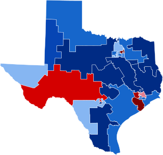
The 2003 Texas redistricting was a controversial intercensus state plan that defined new congressional districts. In the 2004 elections, this redistricting supported the Republicans taking a majority of Texas's federal House seats for the first time since Reconstruction. Democrats in both houses of the Texas Legislature staged walkouts, unsuccessfully trying to prevent the changes. Opponents challenged the plan in three suits, combined when the case went to the United States Supreme Court in League of United Latin American Citizens v. Perry (2006).
The 1812–13 United States House of Representatives elections were held on various dates in various states between August 3, 1812 and April 30, 1813. Each state set its own date for its elections to the House of Representatives before the first session of the 13th United States Congress convened on May 24, 1813. They coincided with James Madison being re-elected president.
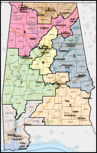
The U.S. state of Alabama is currently divided into seven congressional districts, each represented by a member of the United States House of Representatives.
The 1st congressional district of South Carolina is a coastal congressional district in South Carolina, represented by Republican Nancy Mace since January 3, 2021. She succeeded Democrat Joe Cunningham, having defeated him in the 2020 election. Cunningham was the first Democrat to represent the district since the 1980s.
The 7th congressional district of South Carolina is a congressional district for the United States House of Representatives in South Carolina, established in 2011 following apportionment of another seat to the state in the redistricting cycle following the 2010 census. It is located in the Pee Dee region, and includes all of Chesterfield, Darlington, Dillon, Georgetown, Horry, Marion, and Marlboro Counties and most of Florence County. The district is represented by Republican Russell Fry who was elected in 2022 and took office on January 3, 2023.
The Reapportionment Act of 1929, also known as the Permanent Apportionment Act of 1929, is a combined census and apportionment bill enacted on June 18, 1929, that establishes a permanent method for apportioning a constant 435 seats in the U.S. House of Representatives according to each census. This reapportionment was preceded by the Apportionment Act of 1911 and took effect after the 1932 election meaning that the House was never reapportioned as a result of the 1920 United States Census. Representation in the lower chamber remained frozen for twenty years. The 1929 Act was the culmination of nearly a decade of debate and gridlock that followed the 1920 Census.
The New Jersey Redistricting Commission is a constitutional body of the government of New Jersey tasked with redrawing the state's Congressional election districts after each decade's census. Like Arizona, Idaho, Hawaii, Montana, and Washington; the redistricting is completed within an independent, bipartisan commission. The apportionment of members of the Redistricting Commission is carefully balanced between legislative and executive majorities and is purposefully designed to allow the minority party an equal number of seats on the commission.
Texas has had at-large congressional seats at various times in its history. It was often the case when the state received new congressional seats as a result of reapportionment, that it would have a representative elected from an at-large seat, voted on by all voters in the state. This enabled the legislature, which was dominated by legislators from rural districts, to postpone re-districting that would reduce their power by apportioning districts to recognize the increased population and economic power of the developing major cities.
The 1810 United States House of Representatives elections in New York were held from April 24 to 26, 1810, to elect 17 U.S. Representatives to represent the State of New York in the United States House of Representatives of the 12th United States Congress. At the same time, a vacancy was filled in the 11th United States Congress.
Gerrymandering is the practice of setting boundaries of electoral districts to favor specific political interests within legislative bodies, often resulting in districts with convoluted, winding boundaries rather than compact areas. The term "gerrymandering" was coined after a review of Massachusetts's redistricting maps of 1812 set by Governor Elbridge Gerry noted that one of the districts looked like a mythical salamander.
The 2020 United States redistricting cycle is in progress following the completion of the 2020 United States census. In all fifty states, various bodies are re-drawing state legislative districts. States that are apportioned more than one seat in the United States House of Representatives are also drawing new districts for that legislative body.
REDMAP is a project of the Republican State Leadership Committee of the United States to increase Republican control of congressional seats as well as state legislatures, largely through determination of electoral district boundaries. The project has made effective use of partisan gerrymandering, by relying on previously unavailable mapping software such as Maptitude to improve the precision with which district lines are strategically drawn. The strategy was focused on swing blue states like Pennsylvania, Ohio, Michigan, North Carolina, and Wisconsin where there was a Democratic majority but which they could swing towards Republican with appropriate redistricting. The project was launched in 2010 and estimated to have cost the Republican party around US$30 million.
The 1982 United States House of Representatives elections in Texas occurred on November 2, 1982, to elect the members of the state of Texas's delegation to the United States House of Representatives. Texas had twenty-seven seats in the House, up three from the 1970s, apportioned according to the 1980 United States Census.
Redistricting in North Carolina has been a controversial topic due to allegations and admissions of gerrymandering.
The 2010 United States redistricting cycle took place following the completion of the 2010 United States census. In all fifty states, various bodies re-drew state legislative districts. States that are apportioned more than one seat in the United States House of Representatives also drew new districts for that legislative body. The resulting new districts were first implemented for the 2011 and 2012 elections.
Smiley v. Holm, 285 U.S. 355 (1932), was a decision of the Supreme Court of the United States involving a governor's power to veto a congressional redistricting proposal passed by a state's legislature. In an opinion by Chief Justice Charles Evans Hughes, the Court unanimously held that the U.S. Constitution did not prohibit Minnesota's governor from vetoing that state's redistricting map.
Texas House of Representatives districts, Texas Senate districts, Texas Board of Education districts, and Texas's congressional districts are redistricted once every decade, usually in the year after the decennial United States census. According to the Texas Constitution, redistricting in Texas follows the regular legislative process; it must be passed by both houses of the Texas Legislature and signed by the governor of Texas—unless the legislature has sufficient votes to override a gubernatorial veto. Like many other states in the American South after the passage of the Voting Rights Act of 1965, federal judges and the United States Supreme Court have struck down Texas's congressional and legislative districts on multiple occasions, including in the 1960s, 1970s, 1980s, 1990s, and 2000s.
References
Taylor, William A. Ohio In Congress From 1803 To 1901. Columbus, Ohio: The XX. Century Publishing Co., 1900 (Copyright 1899).
This page is based on this Wikipedia article Text is available under the CC BY-SA 4.0 license; additional terms may apply. Images, videos and audio are available under their respective licenses.