Lawrence County | |
---|---|
Coordinates: 38°35′N82°32′W / 38.59°N 82.54°W | |
Country | United States |
State | Ohio |
Founded | March 1, 1817 |
Named for | James Lawrence |
Seat | Ironton |
Largest city | Ironton |
Area | |
• Total | 457 sq mi (1,180 km2) |
• Land | 453 sq mi (1,170 km2) |
• Water | 3.9 sq mi (10 km2) 0.9% |
Population (2020) | |
• Total | 58,240 |
• Density | 130/sq mi (50/km2) |
Time zone | UTC−5 (Eastern) |
• Summer (DST) | UTC−4 (EDT) |
Congressional district | 2nd |
Website | www |
Lawrence County is the southernmost county of the U.S. state of Ohio. As of the 2020 census, the population was 58,240. [1] Its county seat is Ironton. [2] The county was created in 1815 and later organized in 1817. [3] It is named for James Lawrence, the naval officer famous for the line "do not give up the ship". [4] Lawrence County is part of the Huntington–Ashland metropolitan area.
The earliest European-American settlers, Luke Kelly and his family, and May Keyser, settled at Hanging Rock along the Ohio River in 1796, having migrated from the east. [5] Lawrence County was formed on December 20, 1816, from parts of Gallia and Scioto counties, with the county seat named as Burlington. [6] In 1851, the county seat was moved from Burlington to Ironton. A new courthouse was built at that time. It burned in 1857. The present Lawrence County Courthouse was built in 1908.
Men from Lawrence County served in the Mexican–American War, with at least one having died during that conflict. By 1862, about 3,200 of Lawrence County's men were soldiers in the Union Army in the American Civil War. [7] During World War I, 2,200 of Lawrence County's men served in the armed forces, and 99 died. [8]
According to the U.S. Census Bureau, the county has a total area of 457 square miles (1,180 km2), of which 453 square miles (1,170 km2) is land and 3.9 square miles (10 km2) (0.9%) is water. [9] It is the southernmost county in the state of Ohio and part of Appalachian Ohio.
Census | Pop. | Note | %± |
---|---|---|---|
1820 | 3,499 | — | |
1830 | 5,367 | 53.4% | |
1840 | 9,738 | 81.4% | |
1850 | 15,246 | 56.6% | |
1860 | 23,249 | 52.5% | |
1870 | 31,380 | 35.0% | |
1880 | 39,068 | 24.5% | |
1890 | 39,556 | 1.2% | |
1900 | 39,534 | −0.1% | |
1910 | 39,488 | −0.1% | |
1920 | 39,540 | 0.1% | |
1930 | 44,541 | 12.6% | |
1940 | 46,705 | 4.9% | |
1950 | 49,115 | 5.2% | |
1960 | 55,438 | 12.9% | |
1970 | 56,868 | 2.6% | |
1980 | 63,849 | 12.3% | |
1990 | 61,834 | −3.2% | |
2000 | 62,319 | 0.8% | |
2010 | 62,450 | 0.2% | |
2020 | 58,240 | −6.7% | |
U.S. Decennial Census [10] 1790-1960 [11] 1900-1990 [12] 1990-2000 [13] 2020 [1] |
As of the census [14] of 2000, there were 62,319 people, 24,732 households, and 17,807 families living in the county. The population density was 137 inhabitants per square mile (53/km2). There were 27,189 housing units at an average density of 60 units per square mile (23/km2). The racial makeup of the county was 96.55% White, 2.09% Black or African American, 0.18% Native American, 0.19% Asian, 0.01% Pacific Islander, 0.11% from other races, and 0.88% from two or more races. 0.57% of the population were Hispanic or Latino of any race.
There were 24,732 households, out of which 32.00% had children under the age of 18 living with them, 56.00% were married couples living together, 11.90% had a female householder with no husband present, and 28.00% were non-families. 24.90% of all households were made up of individuals, and 11.20% had someone living alone who was 65 years of age or older. The average household size was 2.49 and the average family size was 2.96.
In the county, the population was spread out, with 24.50% under the age of 18, 8.60% from 18 to 24, 28.00% from 25 to 44, 24.50% from 45 to 64, and 14.40% who were 65 years of age or older. The median age was 38 years. For every 100 females there were 92.20 males. For every 100 females age 18 and over, there were 88.40 males.
The median income for a household in the county was $29,127, and the median income for a family was $35,308. Males had a median income of $30,622 versus $20,961 for females. The per capita income for the county was $14,678. About 15.10% of families and 18.90% of the population were below the poverty line, including 27.30% of those under age 18 and 12.90% of those age 65 or over.
As of the 2010 United States Census, there were 62,450 people, 24,974 households, and 17,405 families living in the county. [15] The population density was 137.7 inhabitants per square mile (53.2/km2). There were 27,603 housing units at an average density of 60.9 per square mile (23.5/km2). [16] The racial makeup of the county was 95.9% white, 2.0% black or African American, 0.4% Asian, 0.2% American Indian, 0.2% from other races, and 1.4% from two or more races. Those of Hispanic or Latino origin made up 0.7% of the population. [15] In terms of ancestry, 18.0% were American, 15.4% were German, 12.9% were Irish, and 10.8% were English. [17] In Lawrence County, less than 1% of people who self-identify as "Irish" are Catholic. Scholars believe this is part of a trend in which people are vaguely aware that at least some of their ancestors come from Ireland, but that population is primarily of "Scots-Irish" or "Ulster Scots" ancestry, and those identifying as "Irish" are simply unaware of the distinction. [18] Those citing "American" ancestry in Lawrence County are of overwhelmingly English extraction, most English Americans identify simply as American because their ancestors have been in North America for centuries—in some cases since the 1600s. [19] [20] [21] [22] [23]
Of the 24,974 households, 32.9% had children under the age of 18 living with them, 51.0% were married couples living together, 13.2% had a female householder with no husband present, 30.3% were non-families, and 26.1% of all households were made up of individuals. The average household size was 2.47 and the average family size was 2.95. The median age was 40.1 years. [15]
The median income for a household in the county was $36,461 and the median income for a family was $46,732. Males had a median income of $38,170 versus $28,251 for females. The per capita income for the county was $19,452. About 15.2% of families and 19.4% of the population were below the poverty line, including 28.0% of those under age 18 and 11.9% of those age 65 or over. [24]
Lawrence County tends to support the Republican Party in presidential elections. Bill Clinton was the last Democrat to win the county, in 1996 – a distinction shared with 16 other Ohio counties, mostly in this region. Despite this fact, Democrats continued to crack 40% in election years.
Year | Republican | Democratic | Third party | |||
---|---|---|---|---|---|---|
No. | % | No. | % | No. | % | |
2020 | 20,306 | 72.06% | 7,489 | 26.58% | 384 | 1.36% |
2016 | 18,689 | 69.76% | 6,974 | 26.03% | 1,126 | 4.20% |
2012 | 14,651 | 56.50% | 10,744 | 41.43% | 537 | 2.07% |
2008 | 15,415 | 56.28% | 11,262 | 41.12% | 713 | 2.60% |
2004 | 15,455 | 55.77% | 12,120 | 43.74% | 135 | 0.49% |
2000 | 12,531 | 51.25% | 11,307 | 46.24% | 614 | 2.51% |
1996 | 8,832 | 36.91% | 11,595 | 48.46% | 3,499 | 14.62% |
1992 | 10,044 | 37.17% | 12,325 | 45.61% | 4,652 | 17.22% |
1988 | 12,937 | 52.23% | 11,628 | 46.95% | 203 | 0.82% |
1984 | 14,793 | 55.96% | 11,431 | 43.24% | 213 | 0.81% |
1980 | 13,799 | 52.68% | 11,366 | 43.39% | 1,029 | 3.93% |
1976 | 10,668 | 46.39% | 12,072 | 52.50% | 256 | 1.11% |
1972 | 15,125 | 67.02% | 7,112 | 31.52% | 330 | 1.46% |
1968 | 9,782 | 46.75% | 8,671 | 41.44% | 2,470 | 11.81% |
1964 | 7,757 | 38.04% | 12,635 | 61.96% | 0 | 0.00% |
1960 | 13,159 | 60.32% | 8,656 | 39.68% | 0 | 0.00% |
1956 | 12,607 | 62.72% | 7,492 | 37.28% | 0 | 0.00% |
1952 | 11,962 | 56.22% | 9,316 | 43.78% | 0 | 0.00% |
1948 | 8,113 | 45.88% | 9,495 | 53.69% | 76 | 0.43% |
1944 | 9,312 | 53.90% | 7,966 | 46.10% | 0 | 0.00% |
1940 | 10,274 | 49.08% | 10,661 | 50.92% | 0 | 0.00% |
1936 | 8,498 | 42.35% | 11,471 | 57.17% | 97 | 0.48% |
1932 | 8,598 | 50.83% | 8,157 | 48.22% | 160 | 0.95% |
1928 | 10,346 | 74.51% | 3,470 | 24.99% | 69 | 0.50% |
1924 | 6,798 | 63.96% | 2,729 | 25.68% | 1,101 | 10.36% |
1920 | 7,616 | 65.08% | 3,955 | 33.80% | 131 | 1.12% |
1916 | 4,363 | 59.10% | 2,821 | 38.21% | 198 | 2.68% |
1912 | 2,650 | 37.39% | 2,042 | 28.81% | 2,395 | 33.79% |
1908 | 5,708 | 66.67% | 2,654 | 31.00% | 200 | 2.34% |
1904 | 5,587 | 72.42% | 1,905 | 24.69% | 223 | 2.89% |
1900 | 5,505 | 64.97% | 2,876 | 33.94% | 92 | 1.09% |
1896 | 5,408 | 63.42% | 3,050 | 35.77% | 69 | 0.81% |
1892 | 4,193 | 56.84% | 2,988 | 40.50% | 196 | 2.66% |
1888 | 4,713 | 59.54% | 3,068 | 38.76% | 135 | 1.71% |
1884 | 4,817 | 60.91% | 3,024 | 38.24% | 67 | 0.85% |
1880 | 4,627 | 61.50% | 2,862 | 38.04% | 34 | 0.45% |
1876 | 3,975 | 57.15% | 2,949 | 42.40% | 31 | 0.45% |
1872 | 3,624 | 68.17% | 1,637 | 30.79% | 55 | 1.03% |
1868 | 3,159 | 65.73% | 1,647 | 34.27% | 0 | 0.00% |
1864 | 2,985 | 72.68% | 1,122 | 27.32% | 0 | 0.00% |
1860 | 1,801 | 55.90% | 1,147 | 35.60% | 274 | 8.50% |
1856 | 743 | 26.58% | 1,150 | 41.14% | 902 | 32.27% |
Lawrence County has a 3-member Board of County Commissioners that oversee the various County departments, similar to all but 2 of the 88 Ohio counties. Lawrence County's elected commissioners are:
Other Lawrence County Elected Officials: County Auditor (R) Paul David Knipp, County Treasurer (R) Tresa Baker, Clerk of Courts (D) Mike Patterson, Sheriff (R) Jeff Lawless, County Recorder (R) Sharon Gossett-Hager.
Primary Political Parties: Lawrence County Democratic Party, Lawrence County Republican Party
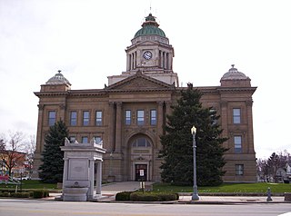
Wyandot County is a county located in the northwestern part of the U.S. state of Ohio. As of the 2020 census, the population was 21,900. Its county seat is Upper Sandusky. It was named for the Wyandot Indians, who lived here before and after European encounter. Their autonym is variously translated from their language as "around the plains" and "dwellers on the peninsula". The county was organized by the state legislature from parts of Crawford, Marion, Hardin and Hancock counties on February 3, 1845.
Williams County is a county located in the U.S. state of Ohio. As of the 2020 census, the population was 37,102. Its county seat is Bryan. The county was created in 1820 and later organized in 1824. It is named for David Williams, one of the captors of John André in the American Revolutionary War.
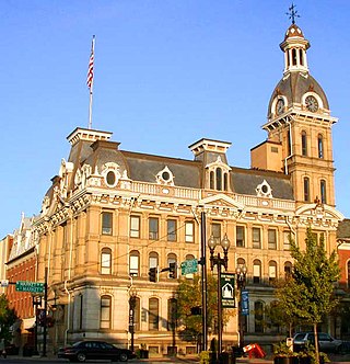
Wayne County is a county in the U.S. state of Ohio. As of the 2020 census, the population was 116,894. Its county seat is Wooster. The county is named for General "Mad" Anthony Wayne. Wayne County comprises the Wooster, OH Micropolitan Statistical Area.
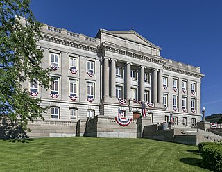
Washington County is a county located in the southeastern part of the U.S. state of Ohio. As of the 2020 census, the population was 59,711. Its county seat is Marietta. The county, the oldest in the state, is named for George Washington. Washington County comprises the Marietta, OH Micropolitan Statistical Area, which is also included in the Parkersburg-Marietta-Vienna, WV-OH Combined Statistical Area.
Morgan County is a county located in the U.S. state of Ohio. As of the 2020 census, the population was 13,802, making it the third-least populous county in Ohio. Its county seat is McConnelsville. The county was created in 1817 and later organized in 1819. It is named for Daniel Morgan, an officer in the American Revolutionary War.
Jackson County is a county located in the U.S. state of Ohio. As of the 2020 census, the population was 32,653. Its county seat is Jackson. The county is named for Andrew Jackson, a hero of the War of 1812 who was subsequently elected President of the United States. It is known as "The Little Wales of Ohio." Jackson County comprises the Jackson, OH Micropolitan Statistical Area.
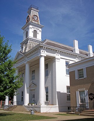
Hardin County is a county located in the west central portion of the U.S. state of Ohio. As of the 2020 census, the population was 30,696. Its county seat and largest city is Kenton. The county was created in 1820 and later organized in 1833. It is named for John Hardin, an officer in the American Revolution.
Gallia County is a county located in the U.S. state of Ohio. As of the 2020 census, the population was 29,220. Its county seat and largest village is Gallipolis.
Defiance County is a county located in the U.S. state of Ohio. As of the 2020 census, the population was 38,286. Its county seat and largest city is Defiance. The county was named after an early Army fortification, Fort Defiance, which was so named by Mad Anthony Wayne to signify the settlers' "defiance" of the Indians. The Defiance, OH Micropolitan Statistical Area includes all of Defiance County.
Crawford County is a county located in the north central portion of the U.S. state of Ohio. As of the 2020 census, the population was 42,025. Its county seat and largest city is Bucyrus. The county was created in 1820 and later organized in 1836. It was named for Colonel William Crawford, a soldier during the American Revolution. Crawford County comprises the Bucyrus, OH Micropolitan Statistical Area, which is also included in the Mansfield-Ashland-Bucyrus, OH Combined Statistical Area.
Champaign County is a county located in the U.S. state of Ohio. As of the 2020 census, the population was 38,714. Its county seat and largest city is Urbana. The county takes its name from the French word for "open level country". Champaign County became the 18th of 88 Ohio counties on March 1, 1805. It was formed from parts of Greene and Franklin counties by legislative action.
Worthington is a home rule-class city on the south bank of the Ohio River in Greenup County, Kentucky, in the United States. The population was 1,609 as of the 2010 U.S. census.
Ironton is a city in Crow Wing County, Minnesota, United States. The population was 572 at the 2010 census. It is part of the Brainerd Micropolitan Statistical Area.
Ironton is a city in Iron County, Missouri, United States. The population was 1,475 at the 2020 census. It is the county seat of Iron County, and is located 12 miles south of Belgrade.
Coal Grove is a village in Lawrence County, Ohio, United States, along the Ohio River. The population was 1,889 at the 2020 census. It borders the city of Ironton and lies across the Ohio River from Ashland, Kentucky. It is linked to Ashland by the Ben Williamson Memorial Bridge and Simeon Willis Memorial Bridge.
Hanging Rock is a village in Lawrence County, Ohio, United States, along the Ohio River. The population was 204 at the 2020 census.
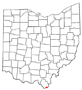
Ironton is a city in and the county seat of Lawrence County, Ohio, United States.The population was 10,571 at the 2020 census. Located in southernmost Ohio along the Ohio River, it is 20 miles (32 km) northwest of Huntington, West Virginia, within the Huntington–Ashland metropolitan area. The city's name is a contraction of "iron town", stemming from its long ties to the iron industry. It also had one of the first professional football teams, the Ironton Tanks.
Proctorville is a village in Lawrence County, Ohio, United States, along the Ohio River. The population was 523 at the 2020 census. The East End Bridge connects Proctorville to Huntington, West Virginia across the Ohio River.
South Point is a village in Lawrence County, Ohio, United States, along the Ohio River. The population was 3,836 at the 2020 census. It is part of the Huntington–Ashland metropolitan area.
Ironton is a village in Sauk County, Wisconsin, United States, along the Little Baraboo River. The population was 253 at the 2010 census. The village is located within the Town of Ironton.
{{cite journal}}
: Cite journal requires |journal=
(help){{cite journal}}
: Cite journal requires |journal=
(help)