Shaka kaSenzangakhona, also known as Shaka Zulu and Sigidi kaSenzangakhona, was the King of the Zulu Kingdom from 1816 to 1828. He was one of the most influential monarchs of the Zulu Kingdom, responsible for re-organizing the Zulu military into a formidable force via a series of wide-reaching and influential reforms.

The Anglo-Zulu War was fought in 1879 between the British Empire and the Zulu Kingdom. Following the Constitution Act of 1867 for the federation in Canada, by Lord Carnarvon, it was thought that similar political effort, coupled with military campaigns, might succeed with the African Kingdoms, tribal areas and Boer republics in South Africa. In 1874, Sir Bartle Frere was sent to South Africa as High Commissioner for the British Empire to effect such plans. Among the obstacles were the armed independent states of the South African Republic and the Kingdom of Zululand.
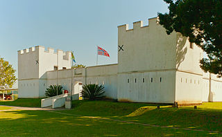
Eshowe is the oldest town of European settlement in Zululand. Eshowe's name is said to be inspired by the sound of wind blowing through the more than 4 km² of the indigenous Dlinza Forest, the most important and striking feature of the town. Although the name is most likely to be derived from the Zulu word for the Xysmalobium shrubs, showe or shongwe.

Cetshwayo kaMpande was the king of the Zulu Kingdom from 1873 to 1879 and its leader during the Anglo-Zulu War of 1879. His name has been transliterated as Cetawayo, Cetewayo, Cetywajo and Ketchwayo. Cetshwayo consistently opposed the war and sought fruitlessly to make peace with the British, and was defeated and exiled following the Zulu defeat in the war. He was later allowed to return to Zululand, where he died in 1884.
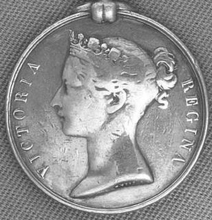
Colonel Henry Lysons VC CB was a British recipient of the Victoria Cross, the highest and most prestigious award for gallantry in the face of the enemy that can be awarded to British and Commonwealth forces.

Henry Cecil Dudgeon D'Arcy VC was a New Zealand-born recipient of the Victoria Cross, the highest and most prestigious award for gallantry in the face of the enemy that can be awarded to British and Commonwealth forces. He won the VC on 3 July 1879 at Ulundi in South Africa during the Anglo-Zulu War when he was 28 years old, and a captain in the Frontier Light Horse.
Utrecht is a town in the foothills of the Balele Mountains, in the northwestern corner of KwaZulu-Natal, South Africa. Newcastle, Kwazulu-Natal's third-largest urban centre, is 50 km from Utrecht. Utrecht has a population of approximately 32,000.

Mtubatuba is a town north of Richards Bay close to the entrance of the iSimangaliso Wetland Park in KwaZulu-Natal, South Africa.

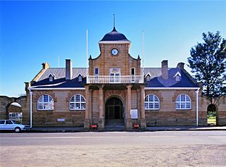
Harrismith is a large town in the Free State province of South Africa. It was named for Sir Harry Smith, a 19th-century British governor and high commissioner of the Cape Colony. It is situated by the Wilge River, alongside the N3 highway, about midway between Johannesburg, about 300 km to the north-west, and Durban to the southeast. The town is located at the junction of the N5 highway, which continues westward towards the provincial capital Bloemfontein, some 340 km to the south-west. This important crossroads in South Africa's land trade routes is surrounded by mesas and buttes. It is located at the base of one of these called Platberg.

The Battle of Kambula took place on 29 March 1879, during the Anglo-Zulu War, when a Zulu military force attacked the British camp at Kambula, having routed the mounted element of the British force at the Battle of Hlobane the day before. The battle was a decisive defeat and the Zulu lost their belief in victory. The war ended after the Zulu defeat at the Battle of Ulundi on 4 July 1879.

The Battle of Hlobane took place at Hlobane, near the modern town of Vryheid in KwaZulu-Natal, South Africa during the Anglo-Zulu War.

The Battle of Intombe was an action fought on 12 March 1879, between Zulu troops and British soldiers defending a supply convoy.
The Natal Native Contingent was a large force of auxiliary soldiers in British South Africa, forming a substantial portion of the defence forces of the British colony of Natal. The Contingent saw action during the 1879 Anglo-Zulu War. The Natal Mounted Police was created in 1873 to bolster the defenses of Natal. It enlisted European officers, NCOs and natives. The infantry was created in 1878. Most enlisted troops were drawn from the Basuto and Mponso tribes, which had had long experience fighting the Zulus.
The military history of South Africa chronicles a vast time period and complex events from the dawn of history until the present time. It covers civil wars and wars of aggression and of self-defence both within South Africa and against it. It includes the history of battles fought in the territories of modern South Africa in neighbouring territories, in both world wars and in modern international conflicts.

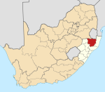
AbaQulusi Local Municipality is a local municipality in Zululand in the KwaZulu-Natal province of South Africa. It is named after the AbaQulusi, a Zulu clan whose descendants live in the vicinities of Vryheid, Utrecht, eDumbe and eNgoje. They hailed from different origins but were unified by their allegiance to local Zulu royal homesteads. Historically they were not drafted into ordinary "amabutho" regiments but rather into a royal section, and no "umnumzane" chief presented them in the Zulu king's council.

The Zulu Kingdom, sometimes referred to as the Zulu Empire or the Kingdom of Zululand, was a monarchy in Southern Africa that extended along the coast of the Indian Ocean from the Tugela River in the south to Pongola River in the north.
The Frontier Light Horse, a mounted unit of 200 volunteers, was raised at King William's Town, Eastern Cape Colony in 1877 by Lieutenant Frederick Carrington.
The abaQulusi or Qulusi are a zulu tribe from South Africa. They are based in the abaqulusi district, Kwazulu-Natal, that bears their name.
uHamu kaNzibe or Hamu kaNzibe was a zulu renegade, half-brother and great rival of king Cetshwayo.
Cornelius Vijn, also known as Viljoen, was a Dutch trader who was taken from his homestead as an advisor for Cetshwayo during the Anglo-Zulu War. He would gain fame after publishing his personal journal relating his experience under the Zulu monarch.