Holden Village, Washington

Last updated

USA Washington location map.svg
Red pog.svg
Holden Village
Location of Holden Village in the state of Washington, US (click on marker for GeoHack map)

Holden Village is a year-round Lutheran [1] Christian center in the North Cascade mountains of the U.S. state of Washington. Formerly the site of one of the largest copper mines in the United States, the Holden mine, Holden is accessible only by a Lake Chelan passenger ferry, or by hiking in through the Cascade Mountains. Holden Village is the largest retreat center in the nation operating under a special use permit from the United States Department of Agriculture - Forest Service. [2]

Contents

Location

Holden Village is located in the Cascade Range in Washington, in the Wenatchee National Forest. [3] [4] [5] Inaccessible by car, visitors (volunteers, guests, and through-hikers) generally take a ferry up Lake Chelan from Chelan or Fields Point Landing to Lucerne where they board a Village bus which takes them up an 11-mile (18 km) gravel road through a set of 12 switchbacks, and into Holden Village. Holden staff and guests greet arriving buses with welcoming applause. It is also possible to hike into Holden Village through the Cascade mountains using a number of routes.

History

Mining era (1896–1957)

In 1896, James Henry Holden made his first claim on the area which would later become Holden Village. [6] However, because of the expense and difficulty involved in transporting copper from the isolated mine, the operation did not begin its full productivity until 1937. By 1938 the mine had become successful and processed 2,000 short tons (1,800 tonnes) of copper ore daily. [6] With the success of the mine came miners and their families, still recovering from the Great Depression. The Howe Sound Company, which owned the mine at the time, built a townsite on the north side of Railroad Creek soon after the mine began to thrive. The townsite, Holden, Washington, consisted of a number of dormitories, a gymnasium, bowling alley, mess hall, school, and hospital, among other things. West of the townsite was a patch of small houses intended for miners with families in tow.

The Holden Mine and the town of Holden flourished for many years despite the isolation. However, after World War II the price of metals fell and the resources of the mine began to diminish. The mine was closed in 1957.

The Village (1961–present)

With the closing of the mine in 1957, the Howe Sound Company sought a buyer for the Holden Mine and townsite. With an asking price of $100,000, the remote piece of property did not sell. However, Wes Prieb, a man active in the Lutheran Bible Institute (now known as Trinity Lutheran College), saw the potential for a spiritual retreat center at the old mine. Originally he asked the Howe Sound Company to give the mine to the Lutheran Church as a gift. The company initially refused, but eventually agreed to sell the mine and townsite for one dollar. In the end, no money changed hands but the title was transferred to the Bible school in 1960. With the transfer of the mine and buildings came a multitude of problems for the Lutheran Bible Institute. The structures were old and suffering from several years of neglect. Many were becoming structurally unsafe; the remainder did not meet modernized building codes. With the help of large brigades of volunteers from the Lutheran synods of the day, the Village was successfully restored and many of the buildings repurposed. The Village began to function as a summer retreat center soon afterward. Originally, the Lutheran Bible Institute imagined a summer-only center, and kept limited staff on hand for the first few winters. However, both the infrastructure needs of the community and the natural beauty of Holden Village in the winter led to the creation of a year-round retreat center. [7]

Mine remediation

The Howe Sound Company's Holden Mine was profitable in part by making few outlays for the impacts of its on-site operations. For example, the low-grade copper ore was concentrated and the tailings were dumped next to the mine portal, covering many acres of wetlands. Although this practice was not unusual for its time, it took place within a remote and otherwise untouched area subsequently surrounded on three sides by federally designated wilderness (The Glacier Peak Wilderness Area). Modern regulations put into place after the mine's closure prohibited such practices, and ultimately the U.S. Environmental Protection Agency declared the Holden Mine area as a Superfund site. The impact from the former mining operations at Holden are only mild compared to other Superfund sites in the United States in terms of their impact on human populations because the area is so remote from population centers. The waters of Railroad Creek flow directly past the tailing piles, which introduces significant amounts of iron to the water, reducing the stream's biodiversity as well as cementing the stream bed.

Prior to the interim action of 1989, when the tailing piles were covered with gravel, winds above 10 mph (16 km/h) would often spread the fine dust in the tailing piles through the air, lowering air quality locally. Holden and its partner agencies have reduced wind-borne air pollution from the tailing piles by planting trees atop the tailing piles, with mixed success. Federal and state agencies have also sought solutions to mineral contamination of the water flowing from the mine into the Railroad Creek watershed. Rio Tinto Group was identified by the EPA as the Potentially Responsible Party in the EPA's process of identifying the corporate entity currently liable for the remediation costs. The process of finding a mutually agreeable solution to these problems was a long and onerous one, but an agreement was eventually reached. [8] The negotiations between state, federal, and Holden Village entities and the public can be seen in a federal report [9] and its fourteen proposed alternative solutions.

Remediation efforts occurred during the years of 2011–2016. In the summer of 2011, Holden conducted its normal program, but also began to see work and workers (up to 65) in and around the Village. Continuing during the summer of 2012, these "Early Works" projects prepared the way for the "Heavy Construction" years of 2013–2015. During 2013–2015 Holden Village made creative changes to its program as it housed and fed 200+ construction people working in shifts 24/7 on the project. In late 2016 the number of construction workers on site will decrease as the mine projects wrap up, and Holden volunteers will work on Village renewal projects. Holden Village welcomed guests again for Christmas 2016 and New Year's 2017 and restarted normal operations in the spring of 2017. There will then be a five-year period of testing and analysis to determine whether further work will be necessary in the eastern portion of the affected area. If required, this additional work would have an undetermined (at this time, at least) impact on Holden Village. [10] [11] [12]

Holden Village today

Today, Holden Village operates as a year-round retreat center. It relies heavily on volunteers for all day-to-day services. The Village respects and welcomes people of all faiths and backgrounds as a part of its community. Holden Village is inundated with visitors during the summer months when families come to stay for a few days, a week, or a month at a time. Holden Village runs a variety of programming in the summers, with classes focusing on science, theology, art and philosophy for all age levels. Winters in the village are much more quiet, although it is a popular destination during the Christmas and New Year celebrations. Holden Village receives large amounts of snow in the winter (averaging over 260 inches (6.6 m)) making snowshoeing and cross-country skiing favorite activities.

Transportation

What visitors used to see when disembarking from Lady of the Lake at Lucerne Landing Lucern Landing.png
What visitors used to see when disembarking from Lady of the Lake at Lucerne Landing

Holden Village remains nearly as isolated today as it was at its founding, and it is still impossible to reach the Village by car alone. Buses leave Holden Village in the morning and head down the mountain on a treacherous set of switchbacks. The landing on Lake Chelan associated with Holden Village is called Lucerne, and it is here that the buses meet the daily boats coming and going. The Chelan Boat Company, located in Chelan, Washington, runs two boats (the Lady of the Lake II and the Lady Express) to and from the Village. These boats ferry people up and down the lake, making stops at the resort town of Stehekin, trailheads, personal properties, and at Lucerne for visitors of Holden Village. [13] Although some visitors to the Village leave their vehicle in Chelan and take the ferry from the Chelan Boat Dock, others drive part way up the lake to take advantage of the large parking lot at the Field's Point Landing near Twenty-Five Mile Creek State Park. [14] Holden Village operates a bed and breakfast a few miles from Field's Point, catering mostly to Village visitors who want to use this landing. [15]

Hiking

In addition to short day-hikes in the mountains surrounding the Village, through-hikers can reach it on foot from several routes.

Lodge 3 in June 2010 Lodge Two.png
Lodge 3 in June 2010
The Dining Hall's exterior, June 2010 (Copper Peak in background) Holden Dining Hall.png
The Dining Hall's exterior, June 2010 (Copper Peak in background)

Community

The year-round residents of Holden Village are largely volunteers. Most residents have specific jobs—from kitchen duty and housekeeping to heavy equipment mechanic and utilities manager—which they perform throughout the year. Communal living is the norm in the village, and guests are integrated into the volunteer culture. Resident families generally live in a chalet, sometimes with another couple or a second family. Other residents live together in the dormitories, called lodges. Meals are eaten together at prescribed times in the dining hall, and meat is served sparingly. While guests and volunteers are given wide latitude concerning how they spend their time during the day, Holden Village expects everyone to come together for the evening Vespers service each day and the Sunday service. Holden Village is known for the Holden Evening Prayer (known as Vespers '86 in the Village) service, a form of the traditional Vespers. Holden Evening Prayer was composed by Marty Haugen, a prolific liturgical composer, while he was on sabbatical in the Village during the winter of 1986.

Domke Lake Fire (2007)

Lucerne landing during the staff evacuation of Holden Village on August 14, 2007 Boatjacket copy.jpg
Lucerne landing during the staff evacuation of Holden Village on August 14, 2007

In August 2007, Holden Village was forced to evacuate approximately 300 guests and staff because of the advance of the nearby Domke Lake Complex wildfire, leaving about 25 staff to maintain and keep the Village operational. While the Village itself was never threatened directly, the fire was in danger of cutting off the single road into the Village. During the emergency, Holden Village provided housing and meals to men and women who were fighting the wildfire. Six weeks later, on September 21, the Village reopened to guests. [21]

Wolverine Fire (2015)

Drought conditions throughout the state of Washington resulted in many devastating wildfires throughout 2015. On June 29, 2015, lightning sparked a fire in Wolverine Creek, [22] which expanded toward Lucerne and became part of the Chelan Complex fire, resulting in the evacuation of the Village (residents, guests, and mine remediation workers) on August 1 and 2, just before the fire cut off road access. A small crew of 4-5 Villagers remained behind to tend the fire defense sprinklers (which operated 24 hours a day using water from Railroad Creek), serve meals to the hotshot firefighter crews working in the nearby mountains, protect the wooden structures from falling embers, and assist with cutting and clearing a protective burn ring around the Village and mine remediation site. The Chelan Complex Fire continued to spread downlake, resulting in the evacuation of the Holden Bed & Breakfast and Lake House on August 15 and threatening the cities of Chelan and Manson. By August 28 the fire had moved on enough to allow some staff members to return, and on September 7 all Villagers were cleared to return. [23] [24] [25]

Climate

Climate data for Holden Village, Washington, 1991–2020 normals, 1962-2020 extremes: 3218ft (981m)
MonthJanFebMarAprMayJunJulAugSepOctNovDecYear
Record high °F (°C)58
(14)
57
(14)
64
(18)
85
(29)
91
(33)
95
(35)
101
(38)
98
(37)
96
(36)
82
(28)
65
(18)
53
(12)
101
(38)
Mean maximum °F (°C)44.5
(6.9)
45.2
(7.3)
54.0
(12.2)
65.3
(18.5)
78.9
(26.1)
85.4
(29.7)
91.5
(33.1)
91.4
(33.0)
83.0
(28.3)
69.3
(20.7)
49.7
(9.8)
41.6
(5.3)
93.4
(34.1)
Mean daily maximum °F (°C)28.2
(−2.1)
33.8
(1.0)
40.9
(4.9)
49.5
(9.7)
60.1
(15.6)
66.4
(19.1)
75.8
(24.3)
75.8
(24.3)
66.5
(19.2)
50.8
(10.4)
34.5
(1.4)
27.2
(−2.7)
50.8
(10.4)
Daily mean °F (°C)22.4
(−5.3)
25.9
(−3.4)
32.1
(0.1)
39.4
(4.1)
48.3
(9.1)
54.4
(12.4)
61.3
(16.3)
61.0
(16.1)
53.2
(11.8)
41.4
(5.2)
29.4
(−1.4)
22.2
(−5.4)
40.9
(5.0)
Mean daily minimum °F (°C)16.7
(−8.5)
18.0
(−7.8)
23.4
(−4.8)
29.2
(−1.6)
36.5
(2.5)
42.5
(5.8)
46.7
(8.2)
46.3
(7.9)
39.8
(4.3)
32.0
(0.0)
24.4
(−4.2)
17.2
(−8.2)
31.1
(−0.5)
Mean minimum °F (°C)−2.0
(−18.9)
0.1
(−17.7)
8.2
(−13.2)
18.9
(−7.3)
25.9
(−3.4)
32.5
(0.3)
36.5
(2.5)
35.1
(1.7)
29.3
(−1.5)
20.5
(−6.4)
9.0
(−12.8)
−0.4
(−18.0)
−7.3
(−21.8)
Record low °F (°C)−22
(−30)
−19
(−28)
−7
(−22)
6
(−14)
15
(−9)
23
(−5)
28
(−2)
23
(−5)
22
(−6)
6
(−14)
−10
(−23)
−32
(−36)
−32
(−36)
Average precipitation inches (mm)6.99
(178)
4.64
(118)
3.99
(101)
1.81
(46)
1.39
(35)
1.24
(31)
0.68
(17)
0.81
(21)
1.67
(42)
4.38
(111)
8.18
(208)
7.20
(183)
42.98
(1,091)
Average snowfall inches (cm)63.80
(162.1)
46.90
(119.1)
34.40
(87.4)
4.00
(10.2)
0.20
(0.51)
0.00
(0.00)
0.00
(0.00)
0.00
(0.00)
0.00
(0.00)
3.20
(8.1)
38.10
(96.8)
83.10
(211.1)
273.7
(695.31)
Average extreme snow depth inches (cm)69
(180)
72
(180)
71
(180)
50
(130)
18
(46)
0
(0)
0
(0)
0
(0)
0
(0)
3
(7.6)
24
(61)
53
(130)
80
(200)
Average precipitation days (≥ 0.01 in)17.414.013.89.69.88.95.05.57.914.317.118.6141.9
Average snowy days (≥ 0.1 in)15.712.610.63.40.20.00.00.00.01.711.217.472.8
Source 1: NOAA [26]
Source 2: XMACIS2 (records, monthly max/min & snow depth) [27]
Climate data for Holden Village, Washington (1981–2010)
MonthJanFebMarAprMayJunJulAugSepOctNovDecYear
Record high °F (°C)58
(14)
57
(14)
64
(18)
85
(29)
91
(33)
101
(38)
101
(38)
98
(37)
96
(36)
82
(28)
65
(18)
60
(16)
101
(38)
Mean maximum °F (°C)44
(7)
47
(8)
55
(13)
65
(18)
78
(26)
85
(29)
91
(33)
91
(33)
82
(28)
70
(21)
51
(11)
43
(6)
93
(34)
Mean daily maximum °F (°C)30.0
(−1.1)
34.6
(1.4)
41.4
(5.2)
51.1
(10.6)
61.8
(16.6)
68.4
(20.2)
77.8
(25.4)
77.6
(25.3)
68.0
(20.0)
52.4
(11.3)
35.4
(1.9)
28.7
(−1.8)
52.3
(11.3)
Daily mean °F (°C)23.4
(−4.8)
26.3
(−3.2)
32.5
(0.3)
39.7
(4.3)
48.7
(9.3)
55.2
(12.9)
61.8
(16.6)
61.5
(16.4)
53.6
(12.0)
41.8
(5.4)
29.9
(−1.2)
22.4
(−5.3)
41.4
(5.2)
Mean daily minimum °F (°C)16.8
(−8.4)
17.1
(−8.3)
22.5
(−5.3)
28.4
(−2.0)
35.5
(1.9)
41.8
(5.4)
46.0
(7.8)
45.6
(7.6)
39.1
(3.9)
31.3
(−0.4)
23.7
(−4.6)
16.3
(−8.7)
30.3
(−0.9)
Mean minimum °F (°C)−3
(−19)
0
(−18)
8
(−13)
19
(−7)
26
(−3)
31
(−1)
36
(2)
35
(2)
29
(−2)
21
(−6)
8
(−13)
−2
(−19)
−9
(−23)
Record low °F (°C)−22
(−30)
−19
(−28)
−7
(−22)
6
(−14)
15
(−9)
23
(−5)
28
(−2)
23
(−5)
22
(−6)
6
(−14)
−10
(−23)
−32
(−36)
−32
(−36)
Average precipitation inches (mm)5.42
(138)
4.51
(115)
2.96
(75)
1.28
(33)
0.99
(25)
1.35
(34)
0.65
(17)
0.95
(24)
1.58
(40)
3.95
(100)
5.43
(138)
5.98
(152)
35.05
(891)
Average snowfall inches (cm)90.1
(229)
66.4
(169)
46.7
(119)
7.9
(20)
0.5
(1.3)
trace0.0
(0.0)
0.0
(0.0)
trace8.5
(22)
51.1
(130)
83.9
(213)
355.1
(903.3)
Source: Desert Research Institute [28]

Related Research Articles

<span class="mw-page-title-main">North Cascades National Park</span> National Park in Washington, US

North Cascades National Park is an American national park in the state of Washington. At more than 500,000 acres (200,000 ha), it is the largest of the three National Park Service units that comprise the North Cascades National Park Complex. North Cascades National Park consists of a northern and southern section, bisected by the Skagit River that flows through the reservoirs of Ross Lake National Recreation Area. Lake Chelan National Recreation Area lies on the southern border of the south unit of the park. In addition to the two national recreation areas, other protected lands including several national forests and wilderness areas, as well as Canadian provincial parks in British Columbia, nearly surround the park. North Cascades National Park features the rugged mountain peaks of the North Cascades Range, the most expansive glacial system in the contiguous United States, the headwaters of numerous waterways, and vast forests with the highest degree of flora biodiversity of any American national park.

<span class="mw-page-title-main">Chelan County, Washington</span> County in Washington, United States

Chelan County is a county in the U.S. state of Washington. As of the 2020 census, its population was 79,074. The county seat and largest city is Wenatchee. The county was created out of Okanogan and Kittitas Counties on March 13, 1899. It derives its name from a Chelan Indian word meaning "deep water," likely a reference to 55-mile (89 km)-long Lake Chelan, which reaches a maximum depth of 1,486 feet (453 m).

<span class="mw-page-title-main">Okanogan–Wenatchee National Forest</span> Protected area in the U.S. state of Washington

The Okanogan–Wenatchee National Forest is a U.S. National Forest located in Okanogan County in north-central Washington, United States.

<span class="mw-page-title-main">Lake Chelan</span> Lake in Chelan County, Washington, United States

Lake Chelan is a narrow, 50.5 mi (81.3 km) long lake in Chelan County, north-central Washington state, U.S. It is an overdeepened lake and resembles a fjord, with an average width of 1.3 mi (2.1 km). Near its upper end, the lake surface lies more than 6,600 ft (2,000 m) below peaks less than 3 mi (4.8 km) away. Before 1927, Lake Chelan was the largest natural lake in the state in terms of both surface area and water volume. Upon the completion of Lake Chelan Dam in 1927, the elevation of the lake was increased by 21 ft (6.4 m) to its present maximum-capacity elevation of 1,100 ft (340 m).

<span class="mw-page-title-main">Stehekin, Washington</span> Unincorporated community in Washington, United States

Stehekin is a small unincorporated community in Chelan County, Washington. The name "Stehekin" comes from a word in the Salishan language that means "the way through". Stehekin has somewhat more than 100 permanent residents, although its population swells during the summer with vacationers and seasonal workers.

<span class="mw-page-title-main">Wenatchee National Forest</span> Protected area in the United States

Wenatchee National Forest is a U.S. National Forest located in Washington. With an area of 1,735,394 acres, it extends about 137 miles along the eastern slopes of the Cascade Range of Washington, USA from Okanogan National Forest to Gifford Pinchot National Forest. The forest is located in Chelan, Kittitas and Yakima counties.

<span class="mw-page-title-main">Stehekin River</span> River in Washington, United States

The Stehekin River is a river located in Washington state in the Pacific Northwest of the United States. It is the main river flowing into Lake Chelan. Miners arrived in Stehekin River Valley in the late 19th century. They were followed by homesteaders in the early 20th century. Today, the Stehekin River Valley is still a remote area that can only be reached by way of a 55-mile boat ride up Lake Chelan.

<span class="mw-page-title-main">Lake Chelan-Sawtooth Wilderness</span> Protected wilderness area in the state of Idaho

The Lake Chelan-Sawtooth Wilderness is a 153,057-acre (61,940 ha) protected wilderness area located within the Okanogan and Wenatchee national forests in Washington State. The wilderness borders Lake Chelan National Recreation Area and North Cascades National Park and the Stephen Mather Wilderness to the northwest. It was designated with the passage of the Washington Wilderness Act of 1984, on lands occupied by the old Chelan Division of the Washington Forest Reserve, now part of both the Okanogan and Wenatchee national forests.

<span class="mw-page-title-main">Glacier Peak Wilderness</span> Wilderness area in the central Cascades of Washington state

Glacier Peak Wilderness is a 566,057-acre (229,075 ha), 35-mile-long (56 km), 20-mile-wide (32 km) wilderness area located within portions of Chelan, Snohomish, and Skagit counties in the North Cascades of Washington. The area lies within parts of Wenatchee National Forest and Mount Baker National Forest and is characterized by heavily forested stream courses, steep-sided valleys, and dramatic glacier-crowned peaks. The dominant geologic feature of the area is 10,541-foot (3,213 m) Glacier Peak. It is the most remote major volcanic peak in the Cascade Range and has more active glaciers than any other place in the lower forty-eight states. Glacier Peak is a volcanic cone of basalt, pumice, and ash which erupted during periods of heavy glaciation.

<span class="mw-page-title-main">Lake Chelan National Recreation Area</span> National recreation area in Chelan County

Lake Chelan National Recreation Area is a national recreation area located about 35 miles (56 km) south of the Canada–US border in Chelan County, Washington. It encompasses an area of 61,958 acres (25,074 ha) including the northern end of Lake Chelan and the surrounding area of the Stehekin Valley and the Stehekin River. The area is managed by the U.S. National Park Service as part of the North Cascades National Park Service Complex.

<span class="mw-page-title-main">The Enchantments</span> Scenic mountains near Leavenworth, Washington, USA

The Enchantments is a region within the Alpine Lakes Wilderness area of Washington state's Cascade Mountain Range. At an elevation of 4,500 feet, it is home to over 700 alpine lakes and ponds surrounded by the vast peaks of Cashmere Crags, which rate among the best rock-climbing sites in the western United States. The highest peak, Dragontail Peak, stretches 8,840 feet high. The Enchantments is located 15 miles southwest of the popular Bavarian-themed town Leavenworth, Washington in the United States and is regarded as one of the most spectacular regions in the Cascade Range.

<span class="mw-page-title-main">2012 Washington wildfires</span>

The 2012 Washington wildfires were a series of 1,342 wildfires that burned 259,526 acres (1,050 km2) over the course of 2012. The fires primarily occurred in the Okanogan and Wenatchee National Forests during September and October 2012. A severe lightning storm on September 8 caused hundreds of fires across the east side of Cascade Range. Smoke caused hazardous air quality conditions in the cities of Ellensburg and Wenatchee, and was noticeable in Seattle. The cost of fighting the largest four fires was estimated to be $67.5 million.

<span class="mw-page-title-main">Image Lake</span> Lake in Snohomish County, Washington, USA

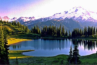
Image Lake is a tarn in Glacier Peak Wilderness, in the North Cascades of Washington, United States. The lake is surrounded by Plummer Peak to the east, a lookout point to the west, the Miners Creek drainage and Glacier Peak to the south, and Canyon Lake to the north. The course of the popular Miners Ridge Trail skirts the lake. Glacier Peak can be seen from the outlet of the lake, and the peak reflected in the lake is a popular photographic subject.

<span class="mw-page-title-main">2014 Washington wildfires</span>

The 2014 Washington wildfires were a series of 1,480 wildfires that burned 386,972 acres (1,566 km2) over the course of 2014. The first occurred primarily on the east side of the Cascade Range in Chelan and Okanogan counties. The fires burned private land, state land, and within the Okanogan and Wenatchee National Forests, ultimately covering over 350,000 acres. The first fire began on July 8 near the Entiat River. On July 14 a lightning storm started dozens more fires across the eastern Cascade Range. Governor Jay Inslee declared a state of emergency, activating the Washington National Guard. More lightning strikes later in the summer started additional fires.

<span class="mw-page-title-main">Oval Peak</span> Mountain in Washington (state), United States

Oval Peak is an 8,800-foot (2,700-metre) mountain in the North Cascades of Washington state. It is protected by the Lake Chelan-Sawtooth Wilderness within the Okanogan–Wenatchee National Forest. Oval Peak is the highest summit in the Methow Mountains, a subrange of the North Cascades. Oval Peak has a small rock glacier on its slopes.

<span class="mw-page-title-main">Lucerne, Washington</span> Unincorporated community in Washington, United States

Lucerne is an unincorporated community in Chelan County, Washington, United States. Lucerne is assigned the ZIP code 98816.

<span class="mw-page-title-main">Courtney Peak (Washington)</span> Mountain in Washington (state), United States

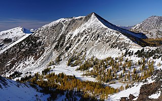
Courtney Peak is an 8,392-foot (2,558-metre) mountain summit located in the Methow Mountains, a sub-range of the North Cascades in Washington state. Situated on Sawtooth Ridge, Courtney Peak is part of the Lake Chelan-Sawtooth Wilderness, a protected area within the Okanogan–Wenatchee National Forest. Courtney Peak ranks 78th on Washington's highest 100 peaks, and 81st on the "Bulger List". The nearest higher peak is Star Peak, 0.83 miles (1.34 km) to the southeast. Precipitation runoff on the west side of the mountain drains into nearby Lake Chelan via Fish Creek, whereas the north side of the mountain drains into Oval Creek, and the east side drains into Buttermilk Creek, both of which are tributaries of the Twisp River. The mountain's name was officially adopted in 1985 to remember James (Ray) Courtney (1920-1982), a commercial packer and lifelong resident of Stehekin. The immediate vicinity of this peak was a favorite destination for his guided outings. Ray Courtney died in an accident while leading such a pack trip with 29 hikers when the horse he was riding lost its footing and fell down a gully.

<span class="mw-page-title-main">Cape Horn (Washington)</span> Mountain in Washington (state), United States

Cape Horn is a 7,316-foot (2,230-metre) mountain summit located in Chelan County of Washington state. Cape Horn is situated 12 mi (19 km) west-northwest of Leavenworth, within the Alpine Lakes Wilderness, on land managed by the Okanogan–Wenatchee National Forest. Cape Horn is part of the Chiwaukum Mountains, a subset of the Cascade Range. Its nearest higher neighbor is Ladies Peak, 0.9 mi (1.4 km) to the northwest, and Grindstone Mountain is set 1.4 mi (2.3 km) to the south. Precipitation runoff from Cape Horn drains west to Icicle Creek, whereas the east slopes drain into Chiwaukum Creek, and both are tributaries of the Wenatchee River. Although modest in elevation, relief is significant since this peak rises over 4,300 feet above Icicle Creek Valley in approximately two miles. This mountain was named by Albert Hale Sylvester in 1909 for its sharp profile.

Myrtle Lake is a freshwater lake located on the northern slope of Rampart Mountain East of Cow Creek Meadows, in Chelan County, Washington. Self-issued Alpine Lake Wilderness permit required for transit within the Glacier Peak Wilderness area. Because Myrtle Lake is at the heart of the Alpine Lakes Wilderness, the lake is a popular area for hiking, swimming, and fishing brook trout.

<span class="mw-page-title-main">Helmet Butte</span> Mountain of Washington (state)

Helmet Butte is a 7,400+ ft summit located in the Glacier Peak Wilderness of the North Cascades in Washington state.

References

  1. "Holden Village".
  2. "Holden Mine Site Cleanup Conditions and Chronology". US Department of Agriculture - Forest Service - Okanogan-Wenatchee National Forest. Retrieved December 4, 2011.
  3. "Holden Village".
  4. "Holden Village term teaches Augustana students lessons in community, consumerism". March 22, 2008.
  5. Pryne, Eric (September 12, 1996). "Bit Of Haven At Holden Village". The Seattle Times.
  6. 1 2 "Holden Discovery". Archived from the original on October 24, 2006. Retrieved September 3, 2006.
  7. Lutz, Charles P. (1987). Surprising Gift . Holden Village Pr; First Edition. ISBN   978-0-9618617-0-4.
  8. http://www.fs.fed.us/r6/wenatchee/holden-mine/
  9. Holden Mine Update - Summer 2010
  10. "Holden Village : Mine Remediation FAQ" . Retrieved November 22, 2016.
  11. "Holden Village : Volunteer/Work" . Retrieved November 22, 2016.
  12. "Holden Village : Visit" . Retrieved November 22, 2016.
  13. "Lady of the Lake Home Page, Lake Chelan". Archived from the original on September 30, 2008. Retrieved June 28, 2009.
  14. "Okanogan-Wenatchee National Forest - Fields Point Landing" . Retrieved September 6, 2016.
  15. "Holden Village :: Holden Bed & Breakfast". Archived from the original on September 8, 2016. Retrieved September 6, 2016.
  16. "Okanogan-Wenatchee National Forest - Phelps Creek Trail #1511" . Retrieved November 22, 2016.
  17. "Okanogan-Wenatchee National Forest - Hart and Lyman Lake Trail #1256" . Retrieved November 22, 2016.
  18. "Suiattle River Trail — Washington Trails Association" . Retrieved November 22, 2016.
  19. "Stehekin, North Cascades National Parks and Lodging". Archived from the original on October 25, 2016. Retrieved November 22, 2016.
  20. Trail Conditions - North Cascades National Park (U.S. National Park Service) , retrieved November 22, 2016
  21. K.C. Mehaffey (September 21, 2007). "Holden Village Reopening to Guests". Wenatchee World. Retrieved August 27, 2015.
  22. "InciWeb the Incident Information System: Wolverine Fire" . Retrieved August 27, 2015.
  23. "Holden Village :: Wolverine Creek Fire 2015" . Retrieved August 27, 2015.
  24. K.C. Mehaffey (August 5, 2015). "Structures lost at Domke, Holden Village evacuations successful". Wenatchee World. Retrieved August 27, 2015.
  25. "50 homes lost in Chelan wildfires". King 5 News. Colville, WA. August 16, 2015. Archived from the original on August 28, 2015. Retrieved August 27, 2015.
  26. "Holden Village, Washington 1991-2020 Monthly Normals" . Retrieved August 16, 2023.
  27. "xmACIS". National Oceanic and Atmospheric Administration. Retrieved February 19, 2024.
  28. U.S. Climate Data. Retrieved April 29, 2022.

48°11′56.63″N120°46′26.93″W / 48.1990639°N 120.7741472°W / 48.1990639; -120.7741472