Holdenville, Oklahoma

Last updated

Holdenville, Oklahoma
F99 HOLDENVILLE MUNICIPAL AIRPORT FLIGHT CDG-IAH 777 F-GSQM (10350666965).jpg
Flag of Holdenville, Oklahoma.svg
Seal of Holdenville, Oklahoma.png
OKMap-doton-Holdenville.PNG
Location of Holdenville, Oklahoma
Coordinates: 35°05′01″N96°24′06″W / 35.08361°N 96.40167°W / 35.08361; -96.40167
Country United States
State Oklahoma
County Hughes
Founded1895
Incorporated1898
Government
  Type Mayor-Council
Area
[1]
  Total5.04 sq mi (13.05 km2)
  Land5.02 sq mi (13.00 km2)
  Water0.02 sq mi (0.04 km2)
Elevation
[2]
883 ft (269 m)
Population
 (2020)
  Total5,934
  Density1,182.07/sq mi (456.44/km2)
Time zone UTC-6 (Central (CST))
  Summer (DST) UTC-5 (CDT)
ZIP code
74848
Area codes 405 and 572
FIPS code 40-35400 [3]
GNIS feature ID2410774 [2]
Website cityofholdenville.net

Holdenville is a city in and county seat of Hughes County, Oklahoma, United States. [4] The population was 5,934 at the time of the 2020 United States census. [5]

Contents

History

Holdenville traces its origin to a Creek settlement called echo, when translated means "deer". George B. Fentress operated a general store there. A post office called "Fentress" opened there on May 24, 1895. The Choctaw, Oklahoma and Gulf Railroad was constructed in the 1890s from Arkansas to Indian Territory. Between 1895 and 1897, the construction passed through the Creek Nation. During this period, a railroad camp was set up to service the railroad construction. [6] The railroad workers called the camp "Holden" in honor of J.F. Holden, the Auditor and Traffic Manager of Choctaw, Oklahoma, and Gulf Railroad. [6] In 1895, a request was delivered to the U.S. Congress to establish a post office in Holden. The request was rejected because the name was too similar to another post office called "Holder." [6] The proposed name was then altered to "Holdenville" and was accepted. [6]

In 1898, settlers petitioned Indian Territory to incorporate Holdenville as a town. A hearing was granted and on November 14, 1898, Holdenville was incorporated as part of Indian Territory. [6] D. J. Red was elected mayor at the first municipal election, held December 27, 1898. The first city council meeting was held January 4, 1899. [7] The St. Louis, Oklahoma and Southern Railway (later the St. Louis and San Francisco Railway) constructed a line between 1900 and 1901 from Sapulpa to the Red River that passed through Holdenville. [7] An election was held on June 27, 1908, to determine the permanent county seat. Contending communities were Holdenville, Wetumka, Calvin, and Lamar. None of the candidates won a majority, so a runoff election was held on September 10, 1908, between the two top vote-getters, Holdenville and Wetumka. This time, Holdenville won the election. [7]

Until it was named in a grand jury investigation in 1904, Holdenville was a sundown town where African Americans were not allowed to live or even wait for a train. [8] [9]

On April 27, 2024, an EF3 tornado struck the town as part of a larger tornado outbreak that affected the Great Plains region, causing two fatalities and extensive damage. [10]

Geography

Holdenville is located about 75 miles (121 km) from Oklahoma City. [7]

Holdenville sits approximately five miles north of the Holdenville City Lake, eight miles north of the Canadian River, and six miles north of the Little River. The area is mostly wooded and flanked by gently rolling hills, interrupted occasionally by small creeks and streams.

According to the United States Census Bureau, the city has a total area of 4.8 square miles (12 km2), all land.

Climate

Climate data for Holdenville, Oklahoma
MonthJanFebMarAprMayJunJulAugSepOctNovDecYear
Record high °F (°C)81
(27)
90
(32)
96
(36)
98
(37)
98
(37)
108
(42)
112
(44)
118
(48)
113
(45)
100
(38)
88
(31)
84
(29)
118
(48)
Mean daily maximum °F (°C)50
(10)
55
(13)
64
(18)
73
(23)
79
(26)
88
(31)
94
(34)
95
(35)
88
(31)
76
(24)
63
(17)
53
(12)
73
(23)
Mean daily minimum °F (°C)30
(−1)
33
(1)
41
(5)
50
(10)
59
(15)
67
(19)
71
(22)
70
(21)
63
(17)
52
(11)
40
(4)
32
(0)
51
(10)
Record low °F (°C)−12
(−24)
−9
(−23)
−1
(−18)
21
(−6)
33
(1)
46
(8)
50
(10)
47
(8)
32
(0)
14
(−10)
11
(−12)
0
(−18)
−12
(−24)
Average precipitation inches (mm)2.1
(53)
2.0
(51)
2.8
(71)
4.2
(110)
6.0
(150)
4.6
(120)
3.3
(84)
3.2
(81)
3.9
(99)
3.3
(84)
2.4
(61)
2.2
(56)
39.9
(1,010)
Average snowfall inches (cm)2.3
(5.8)
1.7
(4.3)
0.7
(1.8)
0.1
(0.25)
0
(0)
0
(0)
0
(0)
0
(0)
0
(0)
0
(0)
0.1
(0.25)
0.7
(1.8)
5.6
(14)
Average rainy days4.84.75.96.97.57.465.86.15.44.1569.6
Average relative humidity (%)69676158666463595658606662
Source 1: weather.com
Source 2: Weatherbase.com [11]

Demographics

Historical population
CensusPop.Note
1900 749
1910 2,296206.5%
1920 2,93227.7%
1930 7,268147.9%
1940 6,632−8.8%
1950 6,192−6.6%
1960 5,712−7.8%
1970 5,181−9.3%
1980 5,4695.6%
1990 4,792−12.4%
2000 4,732−1.3%
2010 5,77122.0%
2020 5,9342.8%
U.S. Decennial Census [12]

As of the census [3] of 2000, there were 4,732 people, 1,966 households, and 1,236 families residing in the city. The population density was 975.9 inhabitants per square mile (376.8/km2). There were 2,302 housing units at an average density of 474.7 per square mile (183.3/km2). The racial makeup of the city was 75.06% White, 3.44% African American, 14.48% Native American, 0.27% Asian, 0.99% from other races, and 5.75% from two or more races. Hispanic or Latino of any race were 2.45% of the population.

There were 1,966 households, out of which 28.4% had children under the age of 18 living with them, 44.3% were married couples living together, 14.6% had a female householder with no husband present, and 37.1% were non-families. 34.2% of all households were made up of individuals, and 20.0% had someone living alone who was 65 years of age or older. The average household size was 2.31 and the average family size was 2.96.

In the city, the population was spread out, with 24.7% under the age of 18, 8.4% from 18 to 24, 23.2% from 25 to 44, 20.5% from 45 to 64, and 23.2% who were 65 years of age or older. The median age was 40 years. For every 100 females, there were 81.2 males. For every 100 females age 18 and over, there were 76.7 males.

The median income for a household in the city was $20,282, and the median income for a family was $27,175. Males had a median income of $21,020 versus $17,951 for females. The per capita income for the city was $13,326. About 14.8% of families and 20.2% of the population were below the poverty line, including 21.2% of those under age 18 and 18.4% of those age 65 or over.

Economy

Historically, the Holdenville area economy has been based on agriculture. The main crops have been cotton, peanuts, pecans, corn, hay, oats, sweet and Irish potatoes and orchard fruits. [7] Other types of business have supplemented the economy. Covey Corporation manufactured plastic products and employed approximately one hundred fifty workers. Other enterprises included Seamprufe Corporation, a manufacturer of lingerie, and F. B. Fly Company, a producer of fishing tackle. Aquafarms, a catfish processing plant, and the Holdenville State Fish Hatchery also provided employment. In the 1990s Tyson Foods' hog breeding operation and the Earl A. Davis Community Work Center created jobs. [7]

It is home to The Pork Group, a subsidiary of Tyson Foods; the Holdenville State Fish Hatchery, one of four operated by the Oklahoma Department of Wildlife Conservation; the Davis Correctional Facility, a 1,600 bed medium security prison operated by the Corrections Corporation of America; and the Creek Nation Casino, one of many operated by the Muscogee (Creek) Nation.

Recreation

Since May 1934 nearby Holdenville Lake has offered outdoor recreational activities. [7]

Fall Festival

Holdenville celebrates the annual Fall Festival on the first Saturday in October. The Festival includes a parade, classic car show, and an open-air market fair with dozens of booths and vendors. The Fall Festival was originally called Hog Wild Day to celebrate Tyson's contribution to Holdenville's economy, and featured a hog-calling contest, a pigtail contest, a pig-out pie-eating contest, and a greased pig contest.[ citation needed ]

Stroup Park

Stroup Park is the primary recreation area in Holdenville. It contains a playground, baseball diamond, public swimming pool, basketball court, tennis court, skate park, two pavilions, disc golf course, and numerous picnic tables. There is also a one-mile walking path, duck pond, and a smaller adjacent park called Rose Park which mainly consists of flower gardens.[ citation needed ]

Holdenville City Lake

Holdenville City Lake, in addition to providing 80% of the drinking water in Hughes County, is the area's main source of aquatic and woodland recreation. The lake is surrounded by campsites, some of which are equipped with RV hook-ups. There is also a public bath house with restrooms and showers. The lake has two docks, one is covered and reserved for fishing, the other is open-air and used for boat docking. Boats and jet skis are allowed on the lake, but only in certain areas. Tubing, knee-boarding and water skiing are allowed depending on the water level. There are also numerous ATV trails in the vicinity.[ citation needed ]

Education

Primary and Secondary education in and around the city are provided by Holdenville Public Schools and Moss Public Schools.

Infrastructure

Highways

Airports

The Holdenville Municipal Airport is about 1 mile northwest of the town. [13] It has existed since 1943, [13] and Central Airlines made it a regularly-scheduled stop in the 1950s. [14]

Commercial air service is available out of Will Rogers World Airport, about 81 miles west-northwest. [15]

Railroads

Notable people

Related Research Articles

<span class="mw-page-title-main">Logan County, Oklahoma</span> County in Oklahoma, United States

Logan County is a county located in the U.S. state of Oklahoma. As of the 2020 census, the population was 49,555. Its county seat is Guthrie.

<span class="mw-page-title-main">Hughes County, Oklahoma</span> County in Oklahoma, United States

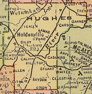
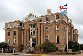
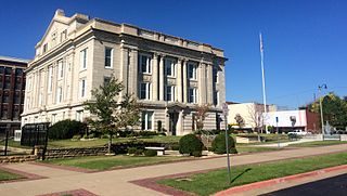
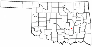
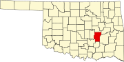
Hughes County is a county located in south central U.S. state of Oklahoma. As of the 2020 census, the population was 13,367. Its county seat is Holdenville. The county was named for W. C. Hughes, an Oklahoma City lawyer who was a member of the Oklahoma Constitutional Convention.

<span class="mw-page-title-main">Creek County, Oklahoma</span> County in Oklahoma, United States

Creek County is a county located in the U.S. state of Oklahoma. As of the 2020 census, the population was 71,754. Its county seat is Sapulpa.

<span class="mw-page-title-main">Seneca, Missouri</span> City in Missouri, United States

Seneca is a city in western Newton County, Missouri, United States. The population was 2,336 at the 2010 census. Located on the southwestern border of the state, the city is part of the Joplin, Missouri Metropolitan Statistical Area.

<span class="mw-page-title-main">Calvin, Oklahoma</span> Town in Oklahoma, United States

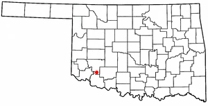
Calvin is a town in Hughes County, Oklahoma, United States. The population was 294 at the 2010 census.

<span class="mw-page-title-main">Dustin, Oklahoma</span> Town in Oklahoma, United States

Dustin is a town in Hughes County, Oklahoma, United States. The population was 327 at the time of the 2020 United States census.

<span class="mw-page-title-main">Horntown, Oklahoma</span> Town in Oklahoma, United States

Horntown is a town in Hughes County, Oklahoma, United States. The population was 97 at the 2010 census, up from the figure of 61 recorded in 2000.

<span class="mw-page-title-main">Stuart, Oklahoma</span> Town in Oklahoma, United States

Stuart is a town in southeastern Hughes County, Oklahoma, United States. The population was 180 at the 2010 census, down from 220 in 2000.

<span class="mw-page-title-main">Wetumka, Oklahoma</span> City in Oklahoma, United States

Wetumka is a city in northern Hughes County, Oklahoma, United States. The population was 1,135 as of the 2020 Census. The Muscogee Creek who first settled it after removal in the 1830s named it for their ancestral town of Wetumpka in Alabama. Wetumka is a Muskogee language word meaning "rumbling waters."

<span class="mw-page-title-main">Snyder, Oklahoma</span> City in Oklahoma, United States

Snyder is a city in Kiowa County, Oklahoma, United States. The population was 1,394 at the 2010 census. This figure represented a decline of 7.6 percent from 1,509 persons in 2000.

<span class="mw-page-title-main">Wilburton, Oklahoma</span> City in Oklahoma, United States

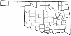
Wilburton is a city in Latimer County, Oklahoma, United States. It is the county seat of Latimer County. The city had a population of 2,285 as of the 2020 Census. Robbers Cave State Park is 5 miles (8.0 km) north of Wilburton.

<span class="mw-page-title-main">Spiro, Oklahoma</span> Town in Oklahoma, United States

Spiro is a town in Le Flore County, Oklahoma, United States. It is part of the Fort Smith, Arkansas-Oklahoma Metropolitan Statistical Area. The population was 2,164 at the 2010 census, a 2.8 percent decline from the figure of 2,227 recorded in 2000.

<span class="mw-page-title-main">Madill, Oklahoma</span> City in Oklahoma, United States

Madill is a city in and the county seat of Marshall County, Oklahoma, United States. It was named in honor of George Alexander Madill, an attorney for the St. Louis-San Francisco Railway. The population at the 2010 census was 3,770, an increase of 10.8 percent from 3,410 at the 2000 census. It is best known as the site of the annual National Sand Bass Festival. It is part of the Texoma region.

<span class="mw-page-title-main">Pryor Creek, Oklahoma</span> City in Oklahoma, United States

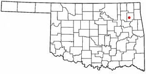
Pryor Creek or Pryor is a city in and county seat of Mayes County, Oklahoma, United States. The population was 8,659 at the 2000 census and 9,539 in the 2010 census.

<span class="mw-page-title-main">Sulphur, Oklahoma</span> City in Oklahoma, United States

Sulphur is a city in and county seat of Murray County, Oklahoma, United States. The population was 5,065 at the 2020 census, a 2.8 percent gain over the figure of 4,929 in 2010. The area around Sulphur has been noted for its mineral springs, since well before the city was founded late in the 19th century. The city received its name from the presence of sulfur in the water.

<span class="mw-page-title-main">Weleetka, Oklahoma</span> Town in Oklahoma, United States

Weleetka is a town in Okfuskee County, Oklahoma, United States. It is approximately 10 miles (16 km) southeast of Okemah, the county seat. The name is a Creek word meaning "running water." The population was 806 at the time of the 2020 census.

<span class="mw-page-title-main">Earlsboro, Oklahoma</span> Town in Oklahoma, United States

Earlsboro is a town in Pottawatomie County, Oklahoma, United States. The population was 594 by the 2020 United States census. It was once called "...the town that whisky built and oil broke."

<span class="mw-page-title-main">Antlers, Oklahoma</span> City in Oklahoma, United States

Antlers is a city in and the county seat of Pushmataha County, Oklahoma, United States. The population was 2,221 as of the 2020 United States census. The town was named for a kind of tree that becomes festooned with antlers shed by deer, and is taken as a sign of the location of a spring frequented by deer.

<span class="mw-page-title-main">Wewoka, Oklahoma</span> City in Oklahoma, United States

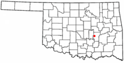
Wewoka is a city in Seminole County, Oklahoma, United States. The population was 3,271 at the 2020 census. It is the county seat of Seminole County.

<span class="mw-page-title-main">Stroud, Oklahoma</span> City in Oklahoma, United States

Stroud is a city in Creek and Lincoln counties in the U.S. state of Oklahoma. As of the 2010 census, the city population was 2,690.

References

  1. "ArcGIS REST Services Directory". United States Census Bureau. Retrieved September 20, 2022.
  2. 1 2 U.S. Geological Survey Geographic Names Information System: Holdenville, Oklahoma
  3. 1 2 "U.S. Census website". United States Census Bureau . Retrieved January 31, 2008.
  4. "Find a County". National Association of Counties. Archived from the original on May 31, 2011. Retrieved June 7, 2011.
  5. "Holdenville (city), Oklahoma". United States Census Bureau. Retrieved March 20, 2024.
  6. 1 2 3 4 5 Crawford, B., et al. (1998). Holdenville - 100 Years and Counting. Marceline, MO: D-Books Publishing, Inc.
  7. 1 2 3 4 5 6 7 Wilson, Linda D. Encyclopedia of Oklahoma History and Culture. "Holdenville." Retrieved October 20, 2013.
  8. "City News Notes". The Fort Smith Times . Fort Smith, Arkansas. May 29, 1904. p. 4 via Newspapers.com. In speaking of his trip Mr. Collins said: '…I ran across three towns in the Indian Territory in which negroes are not allowed to live, and they are Holdenville, Norman and Blackmore. In Holdenville there is one negro, and he is cooking at one of the hotels, but there is talk of compelling him to leave. In the three towns mensioned no negro can either rent a house or buy land. …'
  9. "Considers Conspiracy Law". The Wagoner Echo. Wagoner, Indian Territory. November 19, 1904. p. 5 via Newspapers.com. Now in Durant and other towns in the Central District, and for that matter, in Holdenville, Ada and other towns in the territory notices had been posted for the Negroes not to let the sun go down on them in said towns.
  10. Jonathan Greco (April 28, 2024). "What we know: At least 2 dead in Holdenville; Sulphur sees significant damage after tornado outbreak". KOCO News. Retrieved April 28, 2024.
  11. "Historical Weather for Holdenville, Oklahoma, United States".
  12. "Census of Population and Housing". Census.gov. Retrieved June 4, 2015.
  13. 1 2 "Holdenville Municipal Airport". AirNav.com. Retrieved January 30, 2019.
  14. "Central Airlines Timetable, June 5, 1950". www.timetableimages.com. Retrieved January 29, 2019.
  15. "Will Rogers World Airport to Holdenville, Oklahoma". Google Maps. Retrieved December 24, 2020.
  16. "Oklahoma 2018-2020 State Railroad Map" (PDF). Oklahoma Department of Transportation. Retrieved March 27, 2024.