Related Research Articles
In United States local government, a consolidated city-county is formed when one or more cities and their surrounding county merge into one unified jurisdiction. As such it has the governmental powers of both a municipal corporation and an administrative division of a state.

Suffolk is an independent city in the Commonwealth of Virginia, and as such has no county. As of the 2020 census, the population was 94,324. It is the 9th most populous city in Virginia and the largest city in Virginia by boundary land area as well as the 14th largest in the country.
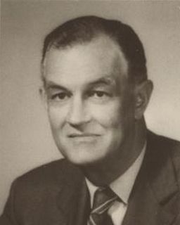
Mills Edwin Godwin Jr. was an American politician who was the 60th and 62nd governor of Virginia for two non-consecutive terms, from 1966 to 1970 and from 1974 to 1978.
The area around Suffolk, Virginia, which is now an independent city in the Hampton Roads region in the southeastern part of the state, was originally inhabited by Native Americans. At the time of European contact, the Nansemond people lived along the river later known by the same name. The area was first explored by Jamestown colonists led by explorer John Smith soon after the settlements founding in 1607, seeking means to survive the inhospitable environment at Jamestown Island.
New Norfolk County is a long-extinct county which was located in colonial Virginia from 1636 until 1637.

Nansemond is an extinct jurisdiction that was located south of the James River in Virginia Colony and in the Commonwealth of Virginia in the United States, from 1646 until 1974. It was known as Nansemond County until 1972. From 1972 to 1974, a period of eighteen months, it was the independent city of Nansemond. It is now part of the independent city of Suffolk.
Upper Norfolk County is an extinct county which was located in colonial Virginia from 1637 until 1646.
Kecoughtan was the name of the settlement now known as Hampton, Virginia, in the seventeenth century. In the early twentieth century, it was also the name of a town developed nearby which was annexed into the City of Newport News in 1927.
The state highway system of the U.S. state of Virginia is a network of roads maintained by the Virginia Department of Transportation (VDOT). As of 2006, the VDOT maintains 57,867 miles (93,128 km) of state highways, making it the third-largest system in the United States.
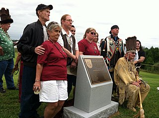
The Nansemond are the indigenous people of the Nansemond River, a 20-mile long tributary of the James River in Virginia. Nansemond people lived in settlements on both sides of the Nansemond River where they fished, harvested oysters, hunted, and farmed in fertile soil.

Driver is a neighborhood in the independent city of Suffolk, Virginia, United States. It is located at the junction of State Route 337, State Route 125, and State Route 627.

The Nansemond River is a 19.8-mile-long (31.9 km) tributary of the James River in Virginia in the United States. Virginian colonists named the river for the Nansemond tribe of Native Americans, who had long inhabited the area. They continue as a federally recognized tribe in Virginia.
The Byrd Road Act was an Act of Assembly passed in February 1932 by the Virginia General Assembly. Named for former Governor Harry F. Byrd, the legislation was originally presented as measure to relieve the financial pressures of the Great Depression upon the counties, as the state offered to take over responsibility and control of most county roads, creating the Virginia Secondary Roads System.
Whaleyville is a neighborhood of Suffolk, Virginia, United States. It was formerly an incorporated town located in southern Nansemond County, Virginia. Whaleyville is located midway between the former county seat at downtown Suffolk and the North Carolina border along U.S. Route 13.

Bennett Creek or Bennett's Creek is a 7.3-mile-long (11.7 km) tributary of the Nansemond River in Suffolk, Virginia.
Nansemond-Suffolk Academy (NSA) is a private school, founded as a segregation academy in 1966 in Suffolk, Virginia. NSA has two campuses. The Main Campus includes 166,000 square feet of educational space situated on a 100 acre wooded campus, and includes the school's athletic facilities and educational space for students from pre-kindergarten to grade 12. The Harbour View Campus, which opened in 2016, includes an additional 22,000 square foot building for students in pre-kindergarten through grade 3.
In the United States, an independent city is a city that is not in the territory of any county or counties and is considered a primary administrative division of its state. Independent cities are classified by the United States Census Bureau as "county equivalents" and may also have similar governmental powers to a consolidated city-county. However, in the case of a consolidated city-county, a city and a county were merged into a unified jurisdiction in which the county at least nominally exists to this day, whereas an independent city was legally separated from any county or merged with a county that simultaneously ceased to exist even in name.
Pughsville is a community in Virginia. It was part of Nansemond County, Virginia which ceased to exist when it was merged into Suffolk, Virginia in the 1970s. The Pughsville community is now in the northern part of Suffolk, Virginia along the border with Chesapeake, Virginia.
References
- ↑ "Archived copy" (PDF). Archived from the original (PDF) on January 15, 2009. Retrieved March 8, 2009.
{{cite web}}: CS1 maint: archived copy as title (link) - ↑ Burns, Adam. "American Rails" . Retrieved June 18, 2020.
- ↑ "Archived copy". Archived from the original on March 9, 2009. Retrieved March 8, 2009.
{{cite web}}: CS1 maint: archived copy as title (link) - ↑ historical-county.newberry.org https://web.archive.org/web/20090727104100/http://historical-county.newberry.org/website/Virginia/documents/VA_Consolidated_Chronology.htm. Archived from the original on July 27, 2009.
{{cite web}}: Missing or empty|title=(help)
Coordinates: 36°40′53″N76°46′49″W / 36.68139°N 76.78028°W
Neighborhoods and municipalities of Suffolk, Virginia | ||
|---|---|---|
| Boroughs | 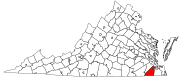 | |
| Neighborhoods | ||
| | This City of Suffolk, Virginia state location article is a stub. You can help Wikipedia by expanding it. |