
Bulgaria is a country situated in Southeast Europe that occupies the eastern quarter of the Balkan peninsula, being the largest country within its geographic boundaries. It borders Romania to the north, Serbia and North Macedonia to the west, Greece and Turkey to the south, and the Black Sea to the east. The northern border with Romania follows the river Danube until the city of Silistra. The land area of Bulgaria is 110,994 square kilometres (42,855 sq mi), slightly larger than that of Cuba, Iceland or the U.S. state of Tennessee. Considering its relatively compact territorial size and shape, Bulgaria has a great variety of topographical features. Even within small parts of the country, the land may be divided into plains, plateaus, hills, mountains, basins, gorges, and deep river valleys. The geographic center of Bulgaria is located in Uzana.

In geology, horst and graben refers to topography consisting of alternating raised and lowered fault blocks known as horsts and grabens. The features are created by normal faulting and rifting caused by crustal extension. Horst and graben are formed when normal faults of opposite dip occur in pairs with parallel strike, and are always formed together. Each feature can range in size from a few centimeters up to tens of kilometers, and the vertical displacement can be up to several thousand meters. The movement on either side of each block is typically equal, resulting in little tilting.
In geology, a graben is a depressed block of the crust of a planet or moon, bordered by parallel normal faults.
An aulacogen is a failed arm of a triple junction. Aulacogens are a part of plate tectonics where oceanic and continental crust is continuously being created, destroyed, and rearranged on the Earth’s surface. Rift zones are places where new crust is formed. An aulacogen is a rift zone that is no longer active.

In geology, a rift is a linear zone where the lithosphere is being pulled apart and is an example of extensional tectonics. Typical rift features are a central linear downfaulted depression, called a graben, or more commonly a half-graben with normal faulting and rift-flank uplifts mainly on one side. Where rifts remain above sea level they form a rift valley, which may be filled by water forming a rift lake. The axis of the rift area may contain volcanic rocks, and active volcanism is a part of many, but not all, active rift systems.
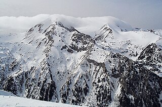
The Pirin Mountains are a mountain range in southwestern Bulgaria, with the highest peak, Vihren, at an altitude of 2,914 m (9,560 ft).

Mountain formation refers to the geological processes that underlie the formation of mountains. These processes are associated with large-scale movements of the Earth's crust. Folding, faulting, volcanic activity, igneous intrusion and metamorphism can all be parts of the orogenic process of mountain building. The formation of mountains is not necessarily related to the geological structures found on it.
Fault blocks are very large blocks of rock, sometimes hundreds of kilometres in extent, created by tectonic and localized stresses in Earth's crust. Large areas of bedrock are broken up into blocks by faults. Blocks are characterized by relatively uniform lithology. The largest of these fault blocks are called crustal blocks. Large crustal blocks broken off from tectonic plates are called terranes. Those terranes which are the full thickness of the lithosphere are called microplates. Continent-sized blocks are called variously microcontinents, continental ribbons, H-blocks, extensional allochthons and outer highs.
The Slyne-Erris Trough is a geological basin off the west coast of Donegal, Ireland.
The Zelten oil field is located at the foot of the Zelten Mountains, about 169 kilometres (105 mi) south of Brega in Concession 6. Zelten holds the title as the largest oil field in the Gulf of Sidra. The 229 wells in Zelten use a gas lifting system. The Zelten oil field is not associated with the town Zelten, which is located in the North-West of Libya.

The Sirte Basin is a late Mesozoic and Cenozoic triple junction continental rift along northern Africa that was initiated during the late Jurassic Period. It borders a relatively stable Paleozoic craton and cratonic sag basins along its southern margins. The province extends offshore into the Mediterranean Sea, with the northern boundary drawn at the 2,000 meter (m) bathymetric contour. It borders in the north on the Gulf of Sidra and extends south into northern Chad.
The Sarir Field was discovered in southern Cyrenaica during 1961 and is considered to be the largest oil field in Libya, with estimated oil reserves of 12 Gbbl (1.9 km3). Sarir is operated by the Arabian Gulf Oil Company (AGOCO), a subsidiary of the state-owned National Oil Corporation (NOC).

Semkovo is a ski resort in the Rila mountain range of southwestern Bulgaria. It is located at 1750 metres above sea level, and is located 17 kilometres from the town of Belitsa in the Razlog Valley.
A half-graben is a geological structure bounded by a fault along one side of its boundaries, unlike a full graben where a depressed block of land is bordered by parallel faults.
A transfer zone in geology is an area where deformational strain is transferred from one structural element to another typically from fault to fault in rift systems. Therefore, listric faults and monoclinal folds in the hanging wall are typical structures linked by transfer zones; however, complexities do exist. The terms interbasin and intrabasin transfer zones have been proposed to delineate the magnitude of the transfer zone. Transfer zones can be described according to the fault dip directions; synthetic or conjugate and according to their deformation style; convergent or divergent. Transfer zones can be farther identified by its maturity or ; whether the major fault relationship is approaching, overlapping, collateral or collinear. Since transfer zones are normally found in extensional settings many studies have been done within the East African rift system and the Gulf of Suez rift system. Transfer zones have also played a role in hydrocarbon exploration and extraction within the Albertine graben.

The North Sea is part of the Atlantic Ocean in northern Europe. It is located between Norway and Denmark in the east, Scotland and England in the west, Germany, the Netherlands, Belgium and France in the south.

The Kutai sedimentary basin extends from the central highlands of Borneo, across the eastern coast of the island and into the Makassar Strait. With an area of 60,000 km2, and depths up to 15 km, the Kutai is the largest and deepest Tertiary age basin in Indonesia. Plate tectonic evolution in the Indonesian region of SE Asia has produced a diverse array of basins in the Cenozoic. The Kutai is an extensional basin in a general foreland setting. Its geologic evolution begins in the mid Eocene and involves phases of extension and rifting, thermal sag, and isostatic subsidence. Rapid, high volume, sedimentation related to uplift and inversion began in the Early Miocene. The different stages of Kutai basin evolution can be roughly correlated to regional and local tectonic events. It is also likely that regional climate, namely the onset of the equatorial ever wet monsoon in early Miocene, has affected the geologic evolution of Borneo and the Kutai basin through the present day. Basin fill is ongoing in the lower Kutai basin, as the modern Mahakam River delta progrades east across the continental shelf of Borneo.
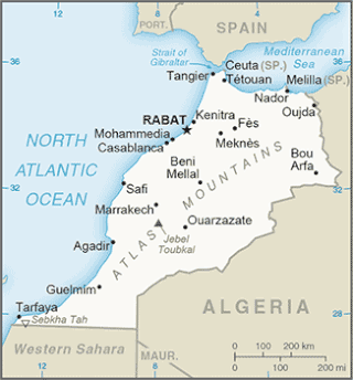
The Tarfaya Basin is a structural basin located in southern Morocco that extends westward into the Moroccan territorial waters in the Atlantic Ocean. The basin is named for the city of Tarfaya located near the border of Western Sahara, a region governed by the Kingdom of Morocco. The Canary Islands form the western edge of the basin and lie approximately 100 km to the west.

The Lusitanian Basin is a rift basin located on both the mainland and continental shelf off the west-central coast of Portugal. It covers an area measuring 20,000 square kilometres (7,700 sq mi) and extends north-south from Porto to Lisbon. The basin varies between approximately 130 kilometres (81 mi) and 340 kilometres (210 mi) in width and belongs to a family of periatlantic basins such as the Jeanne d'Arc Basin. To the east of the Lusitanian Basin lies the Central Plateau of the Iberian Peninsula. A marginal horst system lies to the west. The Alentejo and Algarve Basins connect to the southern end of the Lusitanian Basin. In the north, it connects to the Porto and Galicia Basins via an undersea ridge.

The Melnik Earth Pyramids are rock formations, known as hoodoos, situated at the foothills of the Pirin mountain range in south-western Bulgaria. They span an area of 17 km2 near the town of Melnik, Blagoevgrad Province. Reaching a height of up to 100 m these sandstone pyramids are shaped in forms, resembling giant mushrooms, ancient towers and obelisks. They were formed primarily due to erosion from rainfall and bedrock wear. The Melnik Earth Pyramids are a geological phenomenon of global importance and were declared a natural landmark in 1960. The rock formations are home to rich flora and fauna heavily influenced by the Mediterranean climate. They are a tourist destination due to the natural environment of the area, the cultural sights of Melnik and the Rozhen Monastery.
