Hoyt, Kansas

Last updated

Hoyt, Kansas
Downtown Hoyt.jpg
Downtown Hoyt (2023)
Jackson County Kansas Incorporated and Unincorporated areas Hoyt Highlighted.svg
Location within Jackson County and Kansas
Map of Jackson Co, Ks, USA.png
Coordinates: 39°14′58″N95°42′25″W / 39.24944°N 95.70694°W / 39.24944; -95.70694 [1]
Country United States
State Kansas
County Jackson
Founded1886
Incorporated 1909
Named for George Hoyt
Area
[2]
  Total0.47 sq mi (1.22 km2)
  Land0.47 sq mi (1.22 km2)
  Water0.00 sq mi (0.00 km2)
Elevation
[1]
1,165 ft (355 m)
Population
 (2020) [3]
  Total593
  Density1,300/sq mi (490/km2)
Time zone UTC-6 (CST)
  Summer (DST) UTC-5 (CDT)
ZIP code
66440
Area code 785
FIPS code 20-33375
GNIS ID 2394433 [1]
Website hoytks.net

Hoyt is a city in Jackson County, Kansas, United States. [1] As of the 2020 census, the population of the city was 593. [3]

Contents

History

Hoyt was founded in 1886. [4] It was named for George Henry Hoyt, an abolitionist and attorney for John Brown. [5]

The Chicago, Rock Island and Pacific Railroad originally went through Hoyt and in the late 1890s and early 1900s, Hoyt was a large cattle and hay shipping point between St. Joseph, Missouri and Herington, Kansas. The Rock Island Line as it was often referred to, last operated in 1980. Today, besides aerial photography there is little traces left of the railroad line. [6]

Geography

According to the United States Census Bureau, the city has a total area of 0.50 square miles (1.29 km2), all of it land. [7]

Climate

The climate in this area is characterized by hot, humid summers and generally mild to cool winters. According to the Köppen Climate Classification system, Hoyt has a humid subtropical climate, abbreviated "Cfa" on climate maps. [8]

Demographics

Historical population
CensusPop.Note
1920 282
1930 228−19.1%
1940 2384.4%
1950 2463.4%
1960 28315.0%
1970 42048.4%
1980 53627.6%
1990 489−8.8%
2000 57116.8%
2010 66917.2%
2020 593−11.4%
U.S. Decennial Census

Hoyt is part of the Topeka, Kansas Metropolitan Statistical Area.

2020 census

The 2020 United States census counted 593 people, 238 households, and 157 families in Hoyt. [9] [10] The population density was 1,264.4 per square mile (488.2/km2). There were 259 housing units at an average density of 552.2 per square mile (213.2/km2). [10] [11] The racial makeup was 83.31% (494) white or European American (80.78% non-Hispanic white), 0.67% (4) black or African-American, 6.58% (39) Native American or Alaska Native, 0.67% (4) Asian, 0.17% (1) Pacific Islander or Native Hawaiian, 2.02% (12) from other races, and 6.58% (39) from two or more races. [12] Hispanic or Latino of any race was 4.55% (27) of the population. [13]

Of the 238 households, 37.0% had children under the age of 18; 46.2% were married couples living together; 26.5% had a female householder with no spouse or partner present. 26.9% of households consisted of individuals and 10.1% had someone living alone who was 65 years of age or older. [10] The average household size was 2.3 and the average family size was 2.5. [14] The percent of those with a bachelor’s degree or higher was estimated to be 16.4% of the population. [15]

26.0% of the population was under the age of 18, 7.4% from 18 to 24, 27.2% from 25 to 44, 27.3% from 45 to 64, and 12.1% who were 65 years of age or older. The median age was 36.1 years. For every 100 females, there were 100.3 males. [10] For every 100 females ages 18 and older, there were 101.4 males. [10]

The 2016-2020 5-year American Community Survey estimates show that the median household income was $58,472 (with a margin of error of +/- $13,989) and the median family income was $65,208 (+/- $21,535). [16] Males had a median income of $39,922 (+/- $6,437) versus $40,543 (+/- $6,862) for females. The median income for those above 16 years old was $40,352 (+/- $3,997). [17] Approximately, 11.1% of families and 9.9% of the population were below the poverty line, including 0.0% of those under the age of 18 and 3.7% of those ages 65 or over. [18] [19]

2010 census

As of the census [20] of 2010, there were 669 people, 253 households, and 184 families residing in the city. The population density was 1,338.0 inhabitants per square mile (516.6/km2). There were 269 housing units at an average density of 538.0 per square mile (207.7/km2). The racial makeup of the city was 85.5% White, 0.1% African American, 9.6% Native American, 1.2% Asian, 0.9% from other races, and 2.7% from two or more races. Hispanic or Latino of any race were 5.1% of the population.

There were 253 households, of which 41.9% had children under the age of 18 living with them, 51.0% were married couples living together, 15.8% had a female householder with no husband present, 5.9% had a male householder with no wife present, and 27.3% were non-families. 23.7% of all households were made up of individuals, and 9.1% had someone living alone who was 65 years of age or older. The average household size was 2.64 and the average family size was 3.10.

The median age in the city was 34 years. 30.8% of residents were under the age of 18; 7.9% were between the ages of 18 and 24; 29.6% were from 25 to 44; 21.4% were from 45 to 64; and 10.3% were 65 years of age or older. The gender makeup of the city was 49.2% male and 50.8% female.

2000 census

As of the census [21] of 2000, there were 571 people, 206 households, and 156 families residing in the city. The population density was 1,336.5 inhabitants per square mile (516.0/km2). There were 219 housing units at an average density of 512.6 per square mile (197.9/km2). The racial makeup of the city was 94.05% White, 2.98% Native American, 0.53% Asian, 0.70% from other races, and 1.75% from two or more races. Hispanic or Latino of any race were 2.63% of the population.

There were 206 households, out of which 42.2% had children under the age of 18 living with them, 60.7% were married couples living together, 9.2% had a female householder with no husband present, and 23.8% were non-families. 20.4% of all households were made up of individuals, and 8.7% had someone living alone who was 65 years of age or older. The average household size was 2.77 and the average family size was 3.18.

In the city, the population was spread out, with 32.2% under the age of 18, 7.2% from 18 to 24, 31.3% from 25 to 44, 17.7% from 45 to 64, and 11.6% who were 65 years of age or older. The median age was 31 years. For every 100 females, there were 99.7 males. For every 100 females age 18 and over, there were 99.5 males.

The median income for a household in the city was $46,806, and the median income for a family was $46,806. Males had a median income of $35,188 versus $22,750 for females. The per capita income for the city was $15,116. About 4.2% of families and 7.4% of the population were below the poverty line, including 12.3% of those under age 18 and none of those age 65 or over.

Education

The community is served by Royal Valley USD 337 public school district, and Royal Valley High School.

Related Research Articles

<span class="mw-page-title-main">Moran, Kansas</span> City in Allen County, Kansas

Moran is a city in Allen County, Kansas, United States. As of the 2020 census, the population of the city was 466.

<span class="mw-page-title-main">Morganville, Kansas</span> City in Clay County, Kansas

Morganville is a city in Clay County, Kansas, United States. As of the 2020 census, the population of the city was 180.

<span class="mw-page-title-main">McCune, Kansas</span> City in Crawford County, Kansas

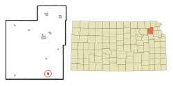
McCune is a city in Crawford County, Kansas, United States. As of the 2020 census, the population of the city was 370.

<span class="mw-page-title-main">Mulberry, Kansas</span> City in Crawford County, Kansas

Mulberry is a city in Crawford County, Kansas, United States. As of the 2020 census, the population of the city was 409.

<span class="mw-page-title-main">Jennings, Kansas</span> City in Decatur County, Kansas

Jennings is a city in Decatur County, Kansas, United States. As of the 2020 census, the population of the city was 81.

<span class="mw-page-title-main">Norcatur, Kansas</span> City in Decatur County, Kansas

Norcatur is a city in Decatur County, Kansas, United States. As of the 2020 census, the population of the city was 159.

<span class="mw-page-title-main">Bucklin, Kansas</span> City in Ford County, Kansas

Bucklin is a city in Ford County, Kansas, United States. As of the 2020 census, the population of the city was 727. It is located along U.S. Route 54 highway.

<span class="mw-page-title-main">Gove City, Kansas</span> City in Gove County, Kansas

Gove City, more commonly known as Gove, is a city in and the county seat of Gove County, Kansas, United States. As of the 2020 census, the population of the city was 80.

<span class="mw-page-title-main">Netawaka, Kansas</span> City in Jackson County, Kansas

Netawaka is a city in Jackson County, Kansas, United States. As of the 2020 census, the population of the city was 139.

<span class="mw-page-title-main">Edgerton, Kansas</span> City in Kansas, United States

Edgerton is a city in Johnson County, Kansas, United States, and part of the Kansas City metropolitan area. As of the 2020 census, the population of the city was 1,748. It is home to a large BNSF intermodal train facility named Logistics Park Kansas City.

<span class="mw-page-title-main">Mission Woods, Kansas</span> City in Kansas, United States

Mission Woods is a city in Johnson County, Kansas, United States, and part of the Kansas City Metropolitan Area. As of the 2020 census, the population of the city was 203.

<span class="mw-page-title-main">Kingman, Kansas</span> City in Kingman County, Kansas

Kingman is a city in and the county seat of Kingman County, Kansas, United States. As of the 2020 census, the population of the city was 3,105.

<span class="mw-page-title-main">Meade, Kansas</span> City in Meade County, Kansas

Meade is a city in and the county seat of Meade County, Kansas, United States. As of the 2020 census, the population of the city was 1,505.

<span class="mw-page-title-main">Ness City, Kansas</span> City in Ness County, Kansas

Ness City is a city in and the county seat of Ness County, Kansas, United States. As of the 2020 census, the population of the city was 1,329. Ness City is famous for its four-story Old Ness County Bank Building located downtown, and nicknamed Skyscraper of the Plains.

<span class="mw-page-title-main">Lyndon, Kansas</span> City in Osage County, Kansas

Lyndon is a city in, and the county seat of Osage County, Kansas, United States. As of the 2020 census, the population of the city was 1,037.

<span class="mw-page-title-main">Belleville, Kansas</span> City in Republic County, Kansas

Belleville is a city in and the county seat of Republic County, Kansas, United States. As of the 2020 census, the population of the city was 2,007.

<span class="mw-page-title-main">Munden, Kansas</span> City in Republic County, Kansas

Munden is a city in Republic County, Kansas, United States. As of the 2020 census, the population of the city was 96.

<span class="mw-page-title-main">Clearwater, Kansas</span> City in Sedgwick County, Kansas

Clearwater is a city in Sedgwick County, Kansas, United States. As of the 2020 census, the population of the city was 2,653.

<span class="mw-page-title-main">Hoxie, Kansas</span> City in Sheridan County, Kansas

Hoxie is a city in and the county seat of Sheridan County, Kansas, United States. As of the 2020 census, the population of the city was 1,211.

<span class="mw-page-title-main">Haddam, Kansas</span> City in Washington County, Kansas

Haddam is a city in Washington County, Kansas, United States. It is named after Haddam, Connecticut. As of the 2020 census, the population of the city was 110.

References

  1. 1 2 3 4 U.S. Geological Survey Geographic Names Information System: Hoyt, Kansas
  2. "2019 U.S. Gazetteer Files". United States Census Bureau. Retrieved July 24, 2020.
  3. 1 2 "Profile of Hoyt, Kansas in 2020". United States Census Bureau. Archived from the original on June 9, 2022. Retrieved June 8, 2022.
  4. Blackmar, Frank Wilson (1912). Kansas: A Cyclopedia of State History, Embracing Events, Institutions, Industries, Counties, Cities, Towns, Prominent Persons, Etc. Standard Publishing Company. pp.  878.
  5. "Profile for Hoyt, Kansas". ePodunk. Archived from the original on July 14, 2014. Retrieved June 11, 2014.
  6. "Kansas State University website" (PDF). Mike Offerman. Retrieved September 2, 2023.
  7. "US Gazetteer files 2010". United States Census Bureau. Archived from the original on January 25, 2012. Retrieved July 6, 2012.
  8. Climate Summary for Hoyt, Kansas
  9. "US Census Bureau, Table P16: HOUSEHOLD TYPE". data.census.gov. Retrieved January 3, 2024.
  10. 1 2 3 4 5 "US Census Bureau, Table DP1: PROFILE OF GENERAL POPULATION AND HOUSING CHARACTERISTICS". data.census.gov. Retrieved January 3, 2024.
  11. Bureau, US Census. "Gazetteer Files". Census.gov. Retrieved December 30, 2023.
  12. "US Census Bureau, Table P1: RACE". data.census.gov. Retrieved January 3, 2024.
  13. "US Census Bureau, Table P2: HISPANIC OR LATINO, AND NOT HISPANIC OR LATINO BY RACE". data.census.gov. Retrieved January 3, 2024.
  14. "US Census Bureau, Table S1101: HOUSEHOLDS AND FAMILIES". data.census.gov. Retrieved January 3, 2024.
  15. "US Census Bureau, Table S1501: EDUCATIONAL ATTAINMENT". data.census.gov. Retrieved January 3, 2024.
  16. "US Census Bureau, Table S1903: MEDIAN INCOME IN THE PAST 12 MONTHS (IN 2020 INFLATION-ADJUSTED DOLLARS)". data.census.gov. Retrieved January 3, 2024.
  17. "US Census Bureau, Table S2001: EARNINGS IN THE PAST 12 MONTHS (IN 2020 INFLATION-ADJUSTED DOLLARS)". data.census.gov. Retrieved January 3, 2024.
  18. "US Census Bureau, Table S1701: POVERTY STATUS IN THE PAST 12 MONTHS". data.census.gov. Retrieved January 3, 2024.
  19. "US Census Bureau, Table S1702: POVERTY STATUS IN THE PAST 12 MONTHS OF FAMILIES". data.census.gov. Retrieved January 3, 2024.
  20. "U.S. Census website". United States Census Bureau . Retrieved July 6, 2012.
  21. "U.S. Census website". United States Census Bureau . Retrieved January 31, 2008.

Further reading