Hudson, Michigan

Last updated
Hudson, Michigan
City of Hudson
Downtown Hudson, MI 2023.jpg
Downtown Hudson along Main Street (M-34)
Motto(s): 
Small town, big heart
Hudson, MI location.png
Location within Lenawee County
USA Michigan location map.svg
Red pog.svg
Hudson
Location within the state of Michigan
Usa edcp location map.svg
Red pog.svg
Hudson
Location within the United States
Coordinates: 41°51′23″N84°21′04″W / 41.85639°N 84.35111°W / 41.85639; -84.35111
CountryUnited States
State Michigan
County Lenawee
Settled1833
Incorporated1893
Government
  Type Council–manager
   Mayor Daniel Schudel
   Manager Charles Weir
   Treasurer Brandon Hudson
Area
[1]
  Total2.20 sq mi (5.69 km2)
  Land2.19 sq mi (5.68 km2)
  Water0.01 sq mi (0.01 km2)
Elevation
915 ft (279 m)
Population
 (2020)
  Total2,415
  Density1,101.73/sq mi (425.30/km2)
Time zone UTC-5 (Eastern (EST))
  Summer (DST) UTC-4 (EDT)
ZIP code(s)
49247
Area code 517
FIPS code 26-39720 [2]
GNIS feature ID0628761 [3]
Website Official website

Hudson is a city in Lenawee County in the U.S. state of Michigan. The population was 2,415 at the 2020 census. The city is mostly surrounded by Hudson Township, but the two are administered autonomously.

Contents

History

Hudson was named for Dr. Daniel Hudson, an original landowner. [4] The city's motto is "Small Town Big Heart." [5]

Geography

Panoramic map of Hudson from 1868 with an image of Union School inset and a listing of area sites Hudson, Lenawee Co., Michigan 1868. LOC 73693430.jpg
Panoramic map of Hudson from 1868 with an image of Union School inset and a listing of area sites

According to the United States Census Bureau, the city has a total area of 2.20 square miles (5.70 km2), of which 2.19 square miles (5.67 km2) is land and 0.01 square miles (0.03 km2) is water. [6]

Major highways

Demographics

Historical population
CensusPop.Note
1860 1,489
1870 2,45064.5%
1880 2,254−8.0%
1890 2,178−3.4%
1900 2,40310.3%
1910 2,178−9.4%
1920 2,46413.1%
1930 2,361−4.2%
1940 2,4262.8%
1950 2,77314.3%
1960 2,546−8.2%
1970 2,6182.8%
1980 2,545−2.8%
1990 2,5801.4%
2000 2,499−3.1%
2010 2,307−7.7%
2020 2,4154.7%
U.S. Decennial Census [7]

2010 census

As of the census [8] of 2010, there were 2,307 people, 861 households, and 599 families residing in the city. The population density was 1,053.4 inhabitants per square mile (406.7/km2). There were 1,019 housing units at an average density of 465.3 per square mile (179.7/km2). The racial makeup of the city was 96.2% White, 0.7% African American, 0.5% Native American, 0.3% Asian, 0.3% from other races, and 1.9% from two or more races. Hispanic or Latino of any race were 4.2% of the population.

There were 861 households, of which 40.3% had children under the age of 18 living with them, 48.7% were married couples living together, 15.6% had a female householder with no husband present, 5.3% had a male householder with no wife present, and 30.4% were non-families. 27.1% of all households were made up of individuals, and 9.2% had someone living alone who was 65 years of age or older. The average household size was 2.63 and the average family size was 3.16.

The median age in the city was 33.4 years. 29.5% of residents were under the age of 18; 9.2% were between the ages of 18 and 24; 25.7% were from 25 to 44; 25% were from 45 to 64; and 10.7% were 65 years of age or older. The gender makeup of the city was 49.0% male and 51.0% female.

2000 census

In 2000 the population density was 1,155.4 inhabitants per square mile (446.1/km2). There were 1,019 housing units at an average density of 471.1 per square mile (181.9/km2). The racial makeup of the city was 96.28% White, 0.32% African American, 0.20% Native American, 0.64% Asian, 0.84% from other races, and 1.72% from two or more races. Hispanic or Latino of any race were 2.16% of the population.

There were 929 households, out of which 38.9% had children under the age of 18 living with them, 52.6% were married couples living together, 14.1% had a female householder with no husband present, and 29.9% were non-families. 24.1% of all households were made up of individuals, and 10.1% had someone living alone who was 65 years of age or older. The average household size was 2.65 and the average family size was 3.15.

In the city, the population was spread out, with 29.7% under the age of 18, 9.4% from 18 to 24, 30.8% from 25 to 44, 19.2% from 45 to 64, and 10.9% who were 65 years of age or older. The median age was 32 years. For every 100 females, there were 91.9 males. For every 100 females age 18 and over, there were 84.4 males.

The median income for a household in the city was $41,122, and the median income for a family was $43,011. Males had a median income of $32,946 versus $23,679 for females. The per capita income for the city was $16,340. About 4.9% of families and 8.0% of the population were below the poverty line, including 8.2% of those under age 18 and 7.2% of those age 65 or over.

Media

Newspaper

Radio

Notable people

Related Research Articles

<span class="mw-page-title-main">Spring Valley, Arizona</span> CDP in Yavapai County, Arizona

Spring Valley is a census-designated place (CDP) in Yavapai County, Arizona, United States. The population was 1,019 at the 2000 census.

<span class="mw-page-title-main">Clay City, Indiana</span> Town in Indiana, United States

Clay City is a town in Harrison Township, Clay County, Indiana, United States. The population was 861 at the 2010 census. It is part of the Terre Haute Metropolitan Statistical Area.

<span class="mw-page-title-main">Paragon, Indiana</span> Town in Indiana, United States

Paragon is a town in Ray Township, Morgan County, in the U.S. state of Indiana. The population was 556 at the 2020 census, down from 659 in 2010.

<span class="mw-page-title-main">Hudson, Indiana</span> Town in Indiana, United States

Hudson is a town in Salem and Steuben townships, Steuben County, in the U.S. state of Indiana. The population was 518 at the 2010 census.

<span class="mw-page-title-main">Urbana, Iowa</span> City in Iowa, United States

Urbana is a city in Benton County, Iowa, United States. The population was 1,554 at the time of the 2020 census. It is part of the Cedar Rapids Metropolitan Statistical Area.

<span class="mw-page-title-main">Hudson, Iowa</span> City in Iowa, United States

Hudson is a city in Black Hawk County, Iowa, United States. The population was 2,546 at the time of the 2020 census. The rural community of Hudson has grown in recent years and is included as a part of the Waterloo-Cedar Falls Metropolitan Statistical Area.

<span class="mw-page-title-main">Oskaloosa, Kansas</span> City and County seat in Kansas, United States

Oskaloosa is a city in and the county seat of Jefferson County, Kansas, United States. As of the 2020 census, the population of the city was 1,110.

<span class="mw-page-title-main">Hudson, Kansas</span> City in Stafford County, Kansas

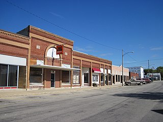
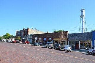
Hudson is a city in Stafford County, Kansas, United States. As of the 2020 census, the population of the city was 95.
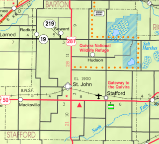
<span class="mw-page-title-main">Waverly, Michigan</span> Census-designated place & unincorporated community in Michigan, United States

Waverly is an unincorporated community in Eaton County in the U.S. state of Michigan. It is a census-designated place (CDP) for statistical purposes and has no legal status as a municipality. The population was 23,925 at the 2010 census, up from 16,194 at the 2000 census. Waverly is home to the Lansing Mall and Waverly Community Schools.

<span class="mw-page-title-main">Lake Shore, Minnesota</span> City in Minnesota, United States

Lake Shore is a city in Cass County, Minnesota, United States. The population was 1,056 at the 2020 census. It is part of the Brainerd Micropolitan Statistical Area.

<span class="mw-page-title-main">Rich Hill, Missouri</span> City in Missouri, United States

Rich Hill is a city in southern Bates County, Missouri, and is part of the Kansas City metropolitan area within the United States. The population was 1,232 at the 2020 census.

<span class="mw-page-title-main">Woodson Terrace, Missouri</span> City in Missouri, United States

Woodson Terrace is a city in St. Louis County, Missouri, United States. The population was 4,063 at the 2010 census.

<span class="mw-page-title-main">Buckner, Missouri</span> City in Missouri, United States

Buckner is a city in Jackson County, Missouri, United States. The population was 2,945 at the 2020 census. For decades it was best known for TV and radio commercials promoting local automobile dealership Lasater Ford, run by the Lasater brothers, Wilson and Milton and later Halverson Ford. It is part of the Kansas City metropolitan area.

<span class="mw-page-title-main">Barnegat (CDP), New Jersey</span> Populated place in Ocean County, New Jersey, US

Barnegat is an unincorporated community and census-designated place (CDP) located within Barnegat Township, in Ocean County, in the U.S. state of New Jersey. As of the 2010 United States census, the CDP's population was 2,817.

<span class="mw-page-title-main">Crown Heights, New York</span> Census-designated place in New York, United States

Crown Heights is a hamlet and census-designated place (CDP) in Dutchess County, New York, United States. The population was 2,840 at the 2010 census. It is part of the Poughkeepsie–Newburgh–Middletown, NY Metropolitan Statistical Area as well as the larger New York–Newark–Bridgeport, NY-NJ-CT-PA Combined Statistical Area.

<span class="mw-page-title-main">Danville, Ohio</span> Village in Ohio, United States

Danville is a village in Knox County, Ohio, United States. The population was 1,019 at the 2020 census.

<span class="mw-page-title-main">Rockaway Beach, Oregon</span> City in Oregon, United States

Rockaway Beach is a city in Tillamook County, Oregon, United States. The population was 1,312 at the 2010 census.

<span class="mw-page-title-main">Mission, Oregon</span> Unincorporated community in the state of Oregon, United States

Mission is an unincorporated community in Umatilla County, Oregon, United States. For statistical purposes, the United States Census Bureau has defined Mission as a census-designated place (CDP). The population was 1,019 at the 2000 census.

<span class="mw-page-title-main">Holland, Sheboygan County, Wisconsin</span> Town in Wisconsin, United States

Holland is a town in Sheboygan County, Wisconsin, United States. The population was 2,360 at the 2000 census. It is included in the Sheboygan, Wisconsin Metropolitan Statistical Area. The unincorporated community of Idlewood Beach is located in the town. The unincorporated community of Dacada is also located partially in the town.

<span class="mw-page-title-main">Gillett, Wisconsin</span> City in Wisconsin, United States

Gillett is a city in Oconto County, Wisconsin, United States. The population was 1,386 at the 2010 census. It is part of the Green Bay Metropolitan Statistical Area. The city is adjacent to the Town of Gillett.

References

  1. "2020 U.S. Gazetteer Files". United States Census Bureau. Retrieved May 21, 2022.
  2. "U.S. Census website". United States Census Bureau . Retrieved 2008-01-31.
  3. U.S. Geological Survey Geographic Names Information System: Hudson, Michigan
  4. Gannett, Henry (1905). The Origin of Certain Place Names in the United States. Govt. Print. Off. pp.  162.
  5. "Hudson Cinema Plaza - Home". www.hudsonmich.com. Retrieved 2017-07-27.
  6. "US Gazetteer files 2010". United States Census Bureau. Archived from the original on 2012-01-25. Retrieved 2012-11-25.
  7. "Census of Population and Housing". Census.gov. Retrieved June 4, 2015.
  8. "U.S. Census website". United States Census Bureau . Retrieved 2012-11-25.
  9. Biographical Note, Bessie Boies Cotton Papers, Sophia Smith Collection, Smith College.