Humansville, Missouri

Last updated

Humansville, Missouri
Humansville, MO.jpg
Downtown Humansville (2024)
Polk County Missouri Incorporated and Unincorporated areas Humansville Highlighted.svg
Location of Humansville, Missouri
Coordinates: 37°47′42″N93°34′36″W / 37.79500°N 93.57667°W / 37.79500; -93.57667
CountryUnited States
State Missouri
County Polk
Area
[1]
  Total1.24 sq mi (3.22 km2)
  Land1.23 sq mi (3.19 km2)
  Water0.01 sq mi (0.03 km2)
Elevation
[2]
965 ft (294 m)
Population
 (2020)
  Total907
  Density737.40/sq mi (284.60/km2)
Time zone UTC-6 (Central (CST))
  Summer (DST) UTC-5 (CDT)
ZIP code
65674
Area code 417
FIPS code 29-33706 [3]
GNIS ID 2394443 [2]

Humansville is a city in Polk County, Missouri, United States. [2] As of the 2020 census, the city population was 965. [4]

Contents

History

A crowd waiting to see and greet President Taft, circa 1910 Humansville, Missouri (circa 1910).jpg
A crowd waiting to see and greet President Taft, circa 1910

Humansville was named after an American settler, Judge James G. Human, who settled in the area in 1834. [5] A post office called Humansville has been in operation since 1839. [6]

During the Civil War, a skirmish was fought on the town's outskirts on March 26, 1862, in which approximately 300 to 400 Missouri Confederates under Col. James M. Frazier of Cedar County clashed with two companies of pro-Union Missouri State Militia. Casualties were few, but Col. Frazier was himself mortally wounded, which caused the Confederates to retreat. [7]

The George Dimmitt Memorial Hospital was listed on the National Register of Historic Places in 2012. [8]

Geography

Humansville sits on Brush Creek and the line of the old Kansas City, Clinton and Springfield Railway. It is 18 mi (29 km) northwest of Bolivar, the seat of Polk County.

According to the United States Census Bureau, the city has a total area of 1.19 square miles (3.08 km2), of which 1.18 square miles (3.06 km2) is land and 0.01 square miles (0.03 km2) is water. [9]

Demographics

Historical population
CensusPop.Note
1880 328
1890 791141.2%
1900 1,05533.4%
1910 913−13.5%
1920 9473.7%
1930 1,0227.9%
1940 786−23.1%
1950 8032.2%
1960 745−7.2%
1970 82510.7%
1980 9079.9%
1990 1,08419.5%
2000 946−12.7%
2010 1,04810.8%
2020 907−13.5%
U.S. Decennial Census

Humansville is part of the Springfield, Missouri Metropolitan Statistical Area.

2010 census

As of the census [10] of 2010, there were 1,048 people, 366 households, and 227 families living in the city. The population density was 888.1 inhabitants per square mile (342.9/km2). There were 461 housing units at an average density of 390.7 per square mile (150.9/km2). The racial makeup of the city was 96.6% White, 0.1% African American, 0.6% Native American, 0.1% Asian, 0.2% from other races, and 2.5% from two or more races. Hispanic or Latino of any race were 3.8% of the population.

There were 366 households, of which 31.7% had children under the age of 18 living with them, 42.3% were married couples living together, 13.9% had a female householder with no husband present, 5.7% had a male householder with no wife present, and 38.0% were non-families. 34.2% of all households were made up of individuals, and 20.2% had someone living alone who was 65 years of age or older. The average household size was 2.42 and the average family size was 3.04.

The median age in the city was 45.9 years. 21.4% of residents were under the age of 18; 7.7% were between the ages of 18 and 24; 20% were from 25 to 44; 25.5% were from 45 to 64; and 25.7% were 65 years of age or older. The gender makeup of the city was 46.9% male and 53.1% female.

2000 census

As of the census [3] of 2000, there were 946 people, 389 households, and 219 families living in the city. The population density was 794.0 inhabitants per square mile (306.6/km2). There were 465 housing units at an average density of 390.3 per square mile (150.7/km2). The racial makeup of the city was 98.20% White, 0.42% African American, 0.32% Native American, 0.21% Asian, and 0.85% from two or more races. Hispanic or Latino of any race were 0.63% of the population.

There were 389 households, out of which 24.7% had children under the age of 18 living with them, 42.4% were married couples living together, 11.6% had a female householder with no husband present, and 43.7% were non-families. 39.3% of all households were made up of individuals, and 22.4% had someone living alone who was 65 years of age or older. The average household size was 2.15 and the average family size was 2.89.

In the city the population was spread out, with 21.2% under the age of 18, 5.5% from 18 to 24, 24.6% from 25 to 44, 20.6% from 45 to 64, and 28.0% who were 65 years of age or older. The median age was 44 years. For every 100 females, there were 86.2 males. For every 100 females age 18 and over, there were 78.7 males.

The median income for a household in the city was $19,821, and the median income for a family was $29,018. Males had a median income of $21,181 versus $14,423 for females. The per capita income for the city was $11,051. About 11.9% of families and 18.7% of the population were below the poverty line, including 16.0% of those under age 18 and 22.0% of those age 65 or over.

Education

Humansville R-IV School District operates one elementary school and Humansville High School. [11]

Humansville has a public library, a branch of the Polk County Library. [12]

Circle of Hope Girls Ranch was located in Humansville.

Transportation

Intercity bus service to the city is provided by Jefferson Lines. [13]

Notable people

See also

Related Research Articles

<span class="mw-page-title-main">Polk County, Missouri</span> County in Missouri, United States

Polk County is a county located in the southwestern portion of the U.S. state of Missouri. As of the 2020 census, the population was 31,519. Its county seat is Bolivar. The county was organized January 5, 1835, and named for Ezekiel Polk.

<span class="mw-page-title-main">Sheldahl, Iowa</span> City in Iowa, United States

Sheldahl is a city in Polk, Boone, and Story counties in the U.S. state of Iowa. The population was 297 at the time of the 2020 census.

<span class="mw-page-title-main">Polk City, Iowa</span> City in Iowa, United States

Polk City is a city in Polk County, Iowa, United States. The population was 5543 in the 2020 census, an increase from 2,344 in 2000. It is part of the Des Moines–West Des Moines Metropolitan Statistical Area.

<span class="mw-page-title-main">Runnells, Iowa</span> City in Iowa, United States

Runnells is a city in the southeastern corner of Polk County, Iowa, United States. The population was 457 at the time of the 2020 census. It is part of the Des Moines–West Des Moines Metropolitan Statistical Area. Runnells has its own Post Office, located at 112 Brown Street.

<span class="mw-page-title-main">Beltrami, Minnesota</span> City in Minnesota, United States

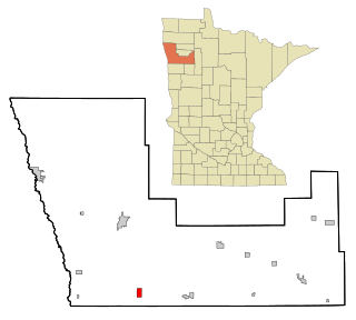
Beltrami is a city in Polk County, Minnesota, United States and was named in honor of Giacomo Costantino Beltrami, an Italian exile, who traveled to the Red river and the upper Mississippi in 1823. Officially incorporated on September 11, 1901, there had been settlers in the area since 1870. It is part of the Grand Forks, ND-MN Metropolitan Statistical Area. The population was 88 at the 2020 census.

<span class="mw-page-title-main">Fisher, Minnesota</span> City in Minnesota, United States

Fisher is a town in Polk County, Minnesota, United States. It is part of the Grand Forks-ND-MN Metropolitan Statistical Area. The population was 422 at the 2020 census. Fisher has become a bedroom community for the nearby Greater Grand Forks Metropolitan Area.

<span class="mw-page-title-main">Gully, Minnesota</span> City in Minnesota, United States

Gully is a city in Polk County, Minnesota, United States. It is part of the Grand Forks-ND-MN Metropolitan Statistical Area. The population was 59 at the 2020 census.

<span class="mw-page-title-main">Linneus, Missouri</span> City in Missouri, United States

Linneus is a small city in Linn County, Missouri, United States. The population was 281 at the 2020 census. It is the county seat of Linn County.

<span class="mw-page-title-main">Tracy, Missouri</span> City in Missouri, United States

Tracy is a city in Platte County, Missouri within the United States, located along the Platte River. The population was 269 at the 2020 census. The city is part of the Kansas City metropolitan area.

<span class="mw-page-title-main">Aldrich, Missouri</span> Village in Missouri, United States

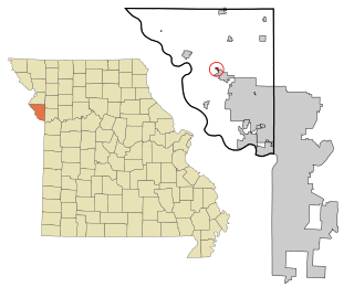
Aldrich is a village in southwestern Polk County, Missouri, United States. The population was 80 at the 2010 census. It is part of the Springfield, Missouri Metropolitan Statistical Area.

<span class="mw-page-title-main">Bolivar, Missouri</span> City in Missouri, United States

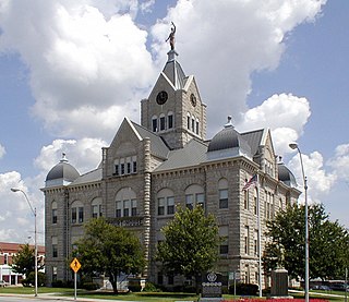
Bolivar is a city and county seat of Polk County, Missouri, United States.

<span class="mw-page-title-main">Fair Play, Missouri</span> City in Missouri, United States

Fair Play is a city in western Polk County, Missouri, United States. The population was 475 at the 2010 census. It is part of the Springfield, Missouri Metropolitan Statistical Area.

<span class="mw-page-title-main">Flemington, Missouri</span> Village in Missouri, United States

Flemington is a village in Polk County, Missouri, United States. The population was 148 at the 2010 census. It is part of the Springfield, Missouri Metropolitan Statistical Area.

<span class="mw-page-title-main">Halfway, Missouri</span> Village in Missouri, United States

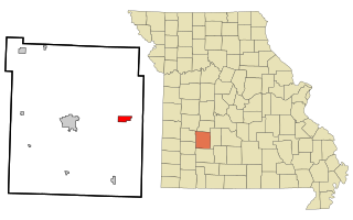
Halfway is a village in Polk County, Missouri, United States. According to the 2010 census, the population of Halfway is 173. It is part of the Springfield, Missouri Metropolitan Statistical Area.

<span class="mw-page-title-main">Morrisville, Missouri</span> City in Missouri, United States

Morrisville is a city in southern Polk County, Missouri, United States. The population was 388 at the 2010 census. It is part of the Springfield, Missouri Metropolitan Statistical Area.

<span class="mw-page-title-main">Pleasant Hope, Missouri</span> City in Missouri, United States

Pleasant Hope is a city in Polk County, Missouri, United States. The population was 614 at the 2010 census. It is part of the Springfield, Missouri Metropolitan Statistical Area.

<span class="mw-page-title-main">Miami, Missouri</span> City in Missouri, United States

Miami is a city in Saline County, Missouri, United States. The population was 175 at the 2010 census.

<span class="mw-page-title-main">Nelson, Missouri</span> City in Missouri, United States

Nelson is a city in Saline County, Missouri, United States. The population was 152 at the 2020 census.

<span class="mw-page-title-main">Crystal Lake Park, Missouri</span> City in Missouri, United States

Crystal Lake Park is a Missouri Class 4 city in St. Louis County, Missouri, United States. The population was 508 at the 2020 census.

<span class="mw-page-title-main">Schell City, Missouri</span> City in Missouri, United States

Schell City is a city in northeast Vernon County, Missouri, United States. The population was 249 at the 2010 census.

References

  1. "ArcGIS REST Services Directory". United States Census Bureau. Retrieved August 28, 2022.
  2. 1 2 3 U.S. Geological Survey Geographic Names Information System: Humansville, Missouri
  3. 1 2 "U.S. Census website". United States Census Bureau . Retrieved January 31, 2008.
  4. "2010 City Population and Housing Occupancy Status". U.S. Census Bureau. Retrieved February 8, 2012.[ dead link ]
  5. Eaton, David Wolfe (1917). How Missouri Counties, Towns and Streams Were Named. The State Historical Society of Missouri. pp.  343.
  6. "Post Offices". Jim Forte Postal History. Retrieved December 10, 2016.
  7. "Missouri and Ozarks History: Skirmish at Humansville". March 9, 2013.
  8. "National Register of Historic Places". Weekly List of Actions Taken on Properties: 3/12/12 through 3/16/12. National Park Service. March 23, 2012.
  9. "US Gazetteer files 2010". United States Census Bureau. Archived from the original on January 12, 2012. Retrieved July 8, 2012.
  10. "U.S. Census website". United States Census Bureau . Retrieved July 8, 2012.
  11. "Humansville R-Iv School District". Great Schools. Retrieved March 18, 2018.
  12. "About us". Polk County Library. Archived from the original on March 18, 2018. Retrieved March 18, 2018.
  13. "Missouri Bus Stops" . Retrieved July 21, 2023.

Further reading