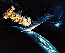
ITOS-E

Last updated

ITOS-E
Mission type Weather
Operator NOAA [1]
Mission durationLaunch failure
Spacecraft properties
Manufacturer RCA Astro
Launch mass747 kilograms (1,647 lb)
Start of mission
Launch dateJuly 16, 1973, 00:00 (1973-07-16Z) UTC [2]
Rocket Delta-300
Launch site Vandenberg SLC-2W
Orbital parameters
Reference system Geocentric
Regime Sun-synchronous
Epoch Planned
  NOAA-2
NOAA-3  
 

ITOS-E was a weather satellite operated by the National Oceanic and Atmospheric Administration (NOAA). It was part of a series of satellites called ITOS, or improved TIROS. [3] ITOS-E was released on July 16, 1973, from the Vandenberg Air Force Base, California, with a Delta rocket, but failed to achieve orbit.

Related Research Articles

<span class="mw-page-title-main">Television Infrared Observation Satellite</span> Series of early American weather satellites

TIROS, or Television InfraRed Observation Satellite, is a series of early weather satellites launched by the United States, beginning with TIROS-1 in 1960. TIROS was the first satellite that was capable of remote sensing of the Earth, enabling scientists to view the Earth from a new perspective: space. The program, promoted by Harry Wexler, proved the usefulness of satellite weather observation, at a time when military reconnaissance satellites were secretly in development or use. TIROS demonstrated at that time that "the key to genius is often simplicity". TIROS is an acronym of "Television InfraRed Observation Satellite" and is also the plural of "tiro" which means "a young soldier, a beginner".

<span class="mw-page-title-main">NOAA-4</span>

NOAA-4, also known as ITOS-G was a weather satellite operated by the National Oceanic and Atmospheric Administration (NOAA). It was part of a series of satellites called ITOS, or improved TIROS. NOAA-4 was launched on a Delta rocket on November 15, 1974. The launch carried two other satellites: AMSAT-OSCAR 7 and Intasat. It remained operational for 1463 days until it was deactivated by NOAA on November 18, 1978.

<span class="mw-page-title-main">Serpentine Galleries</span> Art gallery in Hyde Park, London

The Serpentine Galleries are two contemporary art galleries in Kensington Gardens, Westminster, Greater London. Recently rebranded to just Serpentine, the organisation is split across Serpentine South, previously known as the Serpentine Gallery, and Serpentine North, previously known as the Sackler Gallery. The gallery spaces are within five minutes' walk of each other, linked by the bridge over the Serpentine Lake from which the galleries get their names. Their exhibitions, architecture, education and public programmes attract up to 1.2 million visitors a year. Admission to both galleries is free. The CEO is Bettina Korek, and the artistic director Hans Ulrich Obrist.

Surrey Satellite Technology Ltd, or SSTL, is a company involved in the manufacture and operation of small satellites. A spin-off company of the University of Surrey, it is presently wholly owned by Airbus Defence and Space.

<span class="mw-page-title-main">2005 in spaceflight</span> Spaceflight-related events during 2005

This article outlines notable events occurring in 2005 in spaceflight, including major launches and EVAs. 2005 saw Iran launch its first satellite.

<span class="mw-page-title-main">1971 in spaceflight</span>

1971 saw the last three known deaths of cosmonauts of the Soviet space program and the only deaths in space. Their mission was to man humanity's first space station. The experimental bay door failed to separate so the first crew failed to dock and second crew were killed on re-entry. 1971 also saw the launch of the first and only British satellite on top of a British rocket after that success the program was cancelled.

<span class="mw-page-title-main">Soyuz-FG</span> Launch vehicle

The Soyuz-FG launch vehicle was an improved version of the Soyuz-U from the R-7 family of rockets, designed and constructed by TsSKB-Progress in Samara, Russia. Guidance, navigation, and control system was developed and manufactured by "Polisvit" Special Design Bureau.

Intelsat III F-7 was an American communications satellite owned by Intelsat. The satellite had an estimated useful life of 5 years.

<span class="mw-page-title-main">Explorer 9</span> NASA satellite of the Explorer program

Explorer 9, known as S-56A before launch, was a NASA satellite which was launched in February 1961 to study the density and composition of the upper thermosphere and lower exosphere. It was a reflight of the failed Explorer S-56 mission, and consisted of a 7 kg (15 lb), 3.66 m (12.0 ft) balloon which was deployed into a medium Earth orbit. The mission was conducted by NASA's Langley Research Center.

Deimos-2 is a Spanish remote sensing Earth observation satellite built for Elecnor Deimos under an agreement with Satrec Initiative, a satellite manufacturing company in South Korea.

<span class="mw-page-title-main">Starlink</span> SpaceX satellite constellation and internet service

Starlink is a satellite internet constellation operated by American aerospace company SpaceX, providing coverage to over 60 countries. It also aims for global mobile phone service after 2023.

<span class="mw-page-title-main">TIROS-7</span>

TIROS-7 was a spin-stabilized meteorological satellite. It was the seventh in a series of Television Infrared Observation Satellites.

<span class="mw-page-title-main">TIROS-M</span> Deactivated weather satellite

TIROS-M, also known as ITOS-1 was a weather satellite operated by the Environmental Science Services Administration (ESSA). It was part of a series of satellites called ITOS, or improved TIROS. TIROS-M was launched on a Delta rocket on January 23, 1970. The launch carried one other satellite, Australis-OSCAR 5. It was deactivated on June 18, 1971.

NOAA-1, also known as ITOS-A was a weather satellite operated by the National Oceanic and Atmospheric Administration (NOAA). It was part of a series of satellites called ITOS, or improved TIROS. NOAA-1 was launched on a Delta rocket on December 11, 1970. The launch carried one other satellite: CEP 1. It was deactivated by NOAA on August 19, 1971.

<span class="mw-page-title-main">ITOS-B</span>

NOAA-1 was a weather satellite operated by the National Oceanic and Atmospheric Administration (NOAA). It was part of a series of satellites called ITOS, or improved TIROS. ITOS-B was released on October 21, 1971, from the Vandenberg Air Force Base, California, with a Delta rocket. It failed to achieve a successful earth orbit. A malfunction in the second stage launch vehicle caused the spacecraft to reenter the earth's atmosphere about 1 hour after lift-off.

NOAA-2, also known as ITOS-D was a weather satellite operated by the National Oceanic and Atmospheric Administration (NOAA). It was part of a series of satellites called ITOS, or improved TIROS. NOAA-2 was launched on a Delta rocket on October 15, 1972. The launch carried one other satellite: AMSAT-OSCAR 6.

<span class="mw-page-title-main">NOAA-3</span>

NOAA-3, also known as ITOS-F was a weather satellite operated by the National Oceanic and Atmospheric Administration (NOAA). It was part of a series of satellites called ITOS, or improved TIROS. It was deactivated by NOAA in August 1976.

NOAA-5, also known as ITOS-H was a weather satellite operated by the National Oceanic and Atmospheric Administration (NOAA). It was part of a series of satellites called ITOS, or improved TIROS, being the last of the series. NOAA-5 was launched on a Delta rocket on July 29, 1976.

References

  1. "NASA/NSSDC ITOS-E1 spacecraft details" . Retrieved June 7, 2018.
  2. McDowell, Jonathan. "Launch Log". Jonathan's Space Page. Retrieved June 7, 2018.
  3. Wade, Mark. "ITOS". Encyclopedia Astronautica. Archived from the original on June 21, 2002. Retrieved June 7, 2018.