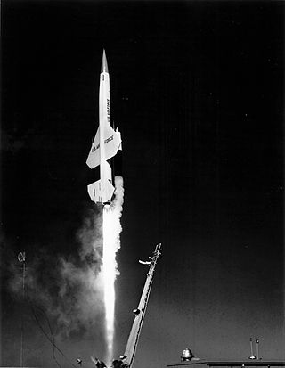
The Boeing CIM-10 BOMARC was a supersonic ramjet powered long-range surface-to-air missile (SAM) used during the Cold War for the air defense of North America. In addition to being the first operational long-range SAM and the first operational pulse doppler aviation radar, it was the only SAM deployed by the United States Air Force.

The Semi-Automatic Ground Environment (SAGE) was a system of large computers and associated networking equipment that coordinated data from many radar sites and processed it to produce a single unified image of the airspace over a wide area. SAGE directed and controlled the NORAD response to a possible Soviet air attack, operating in this role from the late 1950s into the 1980s. Its enormous computers and huge displays remain a part of cold war lore, and after decommissioning were common props in movies such as Dr. Strangelove and Colossus, and on science fiction TV series such as The Time Tunnel.

North American Aerospace Defense Command, known until March 1981 as the North American Air Defense Command, is a combined organization of the United States and Canada that provides aerospace warning, air sovereignty, and protection for Canada, the continental United States, and Alaska.

PAVE PAWS is a complex Cold War early warning radar and computer system developed in 1980 to "detect and characterize a sea-launched ballistic missile attack against the United States". With the first solid-state phased array deployed, the system used a pair of Raytheon AN/FPS-115 phased array radar sets at each site to cover a wide azimuth angle of 240 degrees. Two sites were deployed in 1980 at the periphery of the contiguous United States, then two more in 1987–95, as part of the United States Space Surveillance Network. One system was sold to Taiwan and is still in service.

White Sands Missile Range (WSMR) is a United States Army military testing area and firing range located in the US state of New Mexico. The range was originally established as the White Sands Proving Ground on 9 July 1945. White Sands National Park is located within the range.

Cape Canaveral Space Force Station (CCSFS) is an installation of the United States Space Force's Space Launch Delta 45, located on Cape Canaveral in Brevard County, Florida.

The RCA 474L Ballistic Missile Early Warning System was a United States Air Force Cold War early warning radar, computer, and communications system, for ballistic missile detection. The network of twelve radars, which was constructed beginning in 1958 and became operational in 1961, was built to detect a "mass ballistic missile attack launched on northern approaches [for] 15 to 25 minutes' warning time" also provided Project Space Track satellite data.
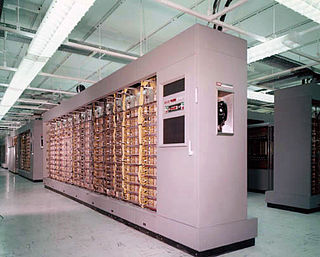
The AN/FSQ-7 Combat Direction Central, referred to as the Q7 for short, was a computerized command and control system for Cold War ground-controlled interception used in the USAF Semi-Automatic Ground Environment (SAGE) air defense network.
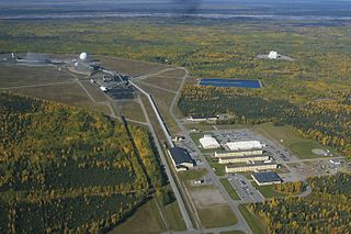
Clear Space Force Station is a United States Space Force radar station for detecting incoming ICBMs and submarine-launched ballistic missiles to NORAD's command center and to provide Space Surveillance data to the United States Space Force. Clear's AN/FPS-123 Upgraded Early Warning Radar is part of the Solid State Phased Array Radar System (SSPARS) which also includes those at Beale AFB, Cape Cod Space Force Station, RAF Fylingdales and Thule Site J. The "historic property" was one of the Alaska World War II Army Airfields and later a Cold War BMEWS site providing NORAD data to Colorado's BMEWS Central Computer and Display Facility (CC&DF).

Aerospace Defense Command was a major command of the United States Air Force, responsible for continental air defense. It was activated in 1968 and disbanded in 1980. Its predecessor, Air Defense Command, was established in 1946, briefly inactivated in 1950, reactivated in 1951, and then redesignated Aerospace rather than Air in 1968. Its mission was to provide air defense of the Continental United States (CONUS). It directly controlled all active measures, and was tasked to coordinate all passive means of air defense.
The IBM AN/FSQ-31 SAC Data Processing System was a USAF command, control, and coordination system for the Cold War Strategic Air Command (SAC). IBM's Federal Systems Division was the prime contractor for the AN/FSQ-31s, which were part of the TBD 465L SAC Automated Command and Control System (SACCS), a "Big L" system of systems (cf. 416L SAGE & 474L BMEWS( which had numerous sites throughout the Continental United States: "all SAC command posts and missile LCC's", a communication network, etc.; and the several FSQ-31 sites including:
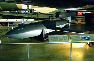
The Republic-Ford JB-2, also known as the Thunderbug, KGW and LTV-N-2 Loon, was a United States copy of the German V-1 flying bomb. Developed in 1944, and planned to be used in the United States invasion of Japan, the JB-2 was never used in combat. It was the most successful of the United States Army Air Forces Jet Bomb (JB) projects during World War II. Postwar, the JB-2 played a significant role in the development of more advanced surface-to-surface tactical missile systems such as the MGM-1 Matador and later MGM-13 Mace.
The 12th Space Warning Squadron is a United States Space Force ground-based radar used for missile warning, missile defense, and space situation awareness, stationed at Thule Air Base, Greenland.

The ASM-N-8 Corvus was an anti-radiation missile developed by Temco Aircraft for the United States Navy.

The Chidlaw Building is a former United States Air Force facility located in the Knob Hill neighborhood of Colorado Springs, Colorado. The building was close to, but not within, the Ent Air Force Base complex, and was leased by the military for several decades, housing headquarters for several military commands, starting with the Air Defense Command (ADC) and the North American Aerospace Defense Command (NORAD). When Chidlaw was completed, personnel from multiple locations, including the Ent Air Force Base, were consolidated into the new building.
The GE AN/GPA-37 Course Directing Group was a USAF Cold War air defense command, control, and coordination system for weapons direction. During Air Defense Command's "Control Capability Improvement Program" to improve command guidance of manned aircraft, the AN/GPA-37 was "developed by the General Electric Heavy Military Electronic Equipment Department at Syracuse in conjunction with...Rome Air Development Center and the Electronics Research Laboratories of Columbia University." Used to process radar data, the system was to "track a potential enemy aircraft and direct intercepters [sic] into a position from which they can make their automatic firing runs", the system included the:

Thule Site J (J-Site) is a United States Space Force (USSF) radar station in Greenland near Thule Air Base for missile warning and spacecraft tracking. The northernmost station of the Solid State Phased Array Radar System, the military installation was built as the 1st site of the RCA 474L Ballistic Missile Early Warning System and had 5 of 12 BMEWS radars. The station has the following structures:
Falling Leaves was an improvised ballistic missile early warning system of the United States Air Force. It was set up during the 1962 Cuban Missile Crisis, and networked 3 existing U.S. radars—2 Space Detection and Tracking System (SPADATS) radars and an Aircraft Control and Warning general surveillance radar which was modified by Sperry Corporation to 1,500 mi (2,400 km) range, allowing detection in space near Cuba. The designation was assigned by the 9th Aerospace Defense Division, headquartered at Ent AFB, Colorado.

The ITT 465L Strategic Air Command Control System was a Cold War "Big L" network of computer and communication systems for command and control of Strategic Air Command "combat aircraft, refueling tankers, [and] ballistic missiles". International Telephone and Telegraph was the prime contractor for Project 465, and SACCS had "Cross Tell Links" between command posts at Offutt AFB, March AFB, & Barksdale AFB (SACCS also communicated with the Cheyenne Mountain Complex and Air Force command posts. The 465L System included IBM AN/FSQ-31 SAC Data Processing Systems, Remote and Simplex Remote Communication Systems, SAC Network Control Office, "4-wire, Schedule 4, Type 4B alternate voice-data operation", and one-way communication with "ICBM launch control centers" In addition to IBM for the "Super SAGE type computers", another of the 6 direct subcontractors was AT&T,

The Missile Warning Center (MWC) is a center that provides missile warning and defense for United States Space Command's Combined Force Space Component Command, incorporating both space-based and terrestrial sensors. The MWC is located at Cheyenne Mountain Space Force Station.

