
Fairfield County is a county in the southwestern corner of the U.S. state of Connecticut. It is the most populous county in the state and was also its fastest-growing from 2010 to 2020. As of the 2020 census, the county's population was 957,419, representing 26.6% of Connecticut's overall population. The closest to the center of the New York metropolitan area, the county contains four of the state's top 7 largest cities—Bridgeport (1st), Stamford (2nd), Norwalk (6th), and Danbury (7th)—whose combined population of 433,368 is nearly half the county's total population.

Stratford is a town in Fairfield County, Connecticut, United States. It is situated on Long Island Sound at the mouth of the Housatonic River. The town is part of the Greater Bridgeport Planning Region, and the Bridgeport–Stamford–Norwalk Metropolitan Statistical Area. It was settled by Puritans in 1639.

The Merritt Parkway is a limited-access parkway in Fairfield County, Connecticut, with a small section at the northern end in New Haven County. Designed for Connecticut's Gold Coast, the parkway is known for its scenic layout, its uniquely styled signage, and the architecturally elaborate overpasses along the route. As one of the first, oldest parkways in the United States, it is designated as a National Scenic Byway and is also listed in the National Register of Historic Places. Signed as part of Route 15, it runs from the New York state line in Greenwich, where it serves to continue the Hutchinson River Parkway, to Exit 54 in Milford, where the Wilbur Cross Parkway begins. Facing bitter opposition, the project took six years to build in three different sections, with the Connecticut Department of Transportation constantly requiring additional funding due to the area's high property value. The parkway was named for U.S. Congressman Schuyler Merritt. In 2010, the National Trust for Historic Preservation called the Merritt Parkway one of "America's 11 Most Endangered Historic Places".

Route 15 is a state highway in the U.S. state of Connecticut that runs 83.53 miles (134.43 km) from a connection with New York's Hutchinson River Parkway in Greenwich, Connecticut, to its northern terminus intersecting with Interstate 84 (I-84) in East Hartford, Connecticut. Route 15 consists of four distinct sections: the Merritt Parkway, the Wilbur Cross Parkway, the Berlin Turnpike, and part of the Wilbur Cross Highway. The unified designation was applied to these separate highways in 1948 to provide a continuous through route from New York to Massachusetts. The parkway section of Route 15 is often referred to locally as "The Merritt".

Route 8 is a 67.36-mile (108.41 km) state highway in Connecticut that runs north–south from Bridgeport, through Waterbury, all the way to the Massachusetts state line where it continues as Massachusetts Route 8. Most of the highway is a four-lane freeway but the northernmost 8.8 miles (14.2 km) is a two-lane surface road.

Interstate 95 (I-95) is the main north–south Interstate Highway on the East Coast of the United States, running in a general east–west compass direction for 111.57 miles (179.55 km) in Connecticut, from the New York state line to the Rhode Island state line. I-95 from Greenwich to East Lyme is part of the Connecticut Turnpike, during which it passes through the major cities of Stamford, Bridgeport, and New Haven. After leaving the turnpike in East Lyme, I-95 is known as the Jewish War Veterans Memorial Highway and passes through New London, Groton, and Mystic, before exiting the state through North Stonington at the Rhode Island border.

The Milford Parkway, officially the Daniel S. Wasson Connector, is a 2.78-mile-long (4.47 km) controlled-access parkway between U.S. Route 1 and the Merritt and Wilbur Cross Parkways in Milford, New Haven County, Connecticut. The highway is officially designated by the Connecticut Department of Transportation as State Road 796 but is not signed as such. As a designated scenic road, commercial vehicles are prohibited from using the Milford Parkway.
The Charter Oak Bridge is one of the three highway bridges over the Connecticut River in Hartford, Connecticut. The twin steel stringer bridge carries the Wilbur Cross Highway over the river, connecting downtown Hartford with East Hartford.
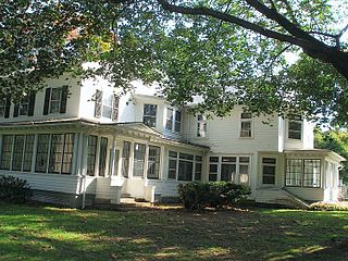
Boothe Memorial Park and Museum sits on a 32-acre (130,000 m2) site in the Putney section of Stratford, Connecticut. Built about 1840 and remodeled in 1914, it is said to be "The Oldest Homestead in America," since it sits on the foundations of a 1663 house, and has been continuously occupied. Circa 1914 two brothers, David Beach Boothe and Stephen Nichols Boothe, created the Boothe Memorial Museum which maintains a collection of twenty architecturally unique buildings. Some of the structures include a carriage house, Americana Museum, miniature lighthouse, windmill, a clock tower museum, trolley station, chapel, and a blacksmith shop. The property became a public park owned by the town of Stratford in 1949.
Nichols, a historic village in southeastern Trumbull in Fairfield County, Connecticut, is named after the family who maintained a large farm in its center for almost 300 years. The Nichols Farms Historic District, which encompasses part of the village, is listed on the National Register of Historic Places. Originally home to the Golden Hill Paugussett Indian Nation, the area was colonized by the English during the Great Migration of the 1630s as a part of the coastal settlement of Stratford. The construction of the Merritt Parkway through the village, and the subsequent closing of stores and factories, turned the village into a bedroom community in 1939. Aviation pioneer Igor Sikorsky lived in three separate homes in Nichols during his active years between 1928 and 1951, when he designed, built and flew fixed-wing aircraft and put the helicopter into mass production for the first time.

Route 108 in the U.S. state of Connecticut, locally called Nichols Avenue and Huntington Turnpike, is a two-lane state highway that runs northerly from US 1, Boston Post Road in Stratford, through Trumbull, to Route 110 in downtown Shelton. Originally called the Farm Highway, it was laid out to the south side of Mischa Hill in Trumbull on December 7, 1696 and is considered to be the third oldest documented highway in Connecticut after the Mohegan Road in Norwich (1670) and the Boston Post Road or US 1 (1673).
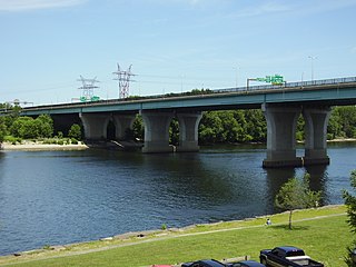
Moses Wheeler Bridge carries Interstate 95 over the Housatonic River between Stratford and the Devon section of Milford. The current bridge is a 14-span continuous girder and floorbeam structure that carries three lanes of traffic in each direction, with full inside and outside shoulders. The current bridge, completed in 2016, replaces a pre-existing structure that was completed as part of the original Connecticut Turnpike in 1958. The original bridge was a 34-span plate girder structure with a concrete deck with three 12-foot travel lanes in each direction and no shoulders. The central span of the original bridge over the river's navigation channel included a pin and hanger assembly, which are no longer used in bridge construction in the United States. Construction on the Moses Wheeler Bridge began in 1955 and opened on January 2, 1958.

The Washington Bridge, also known as the Devon Bridge, carries U.S. Route 1 (US 1) over the Housatonic River in the U.S. state of Connecticut, connecting the city of Milford to the town of Stratford. Its geographic location is N 41.20037 by W −73.11039. It is considered architecturally notable by the National Register of Historic Places for its five 100-foot-long (30 m) arches. It is designated Bridge No. 327 by the state Department of Transportation.

Trumbull, a town in Fairfield County, Connecticut, in the New England region of the United States, was originally home to the Golden Hill Paugussett Indian Nation, and was colonized by the English during the Great Migration of the 1630s as a part of the coastal settlement of Stratford.
Carting Island is the largest of the four islands owned by Stratford, Connecticut in the Housatonic River between I-95 and the Merritt Parkway. The island is north of the Moses Wheeler Bridge, east of Peacock Island (Connecticut), and southwest of Long Island (Connecticut), and Pope's Flat, it is also south of Fowler Island in Milford and the Igor I. Sikorsky Memorial Bridge. The island is uninhabited except for occasional visits by anglers, bird watchers and duck hunters. All transportation to and from the island is by boat.
Pope's Flat is the second largest of the four islands owned by Stratford, Connecticut in the Housatonic River between I-95 and the Merritt Parkway. The island is north of the Moses Wheeler Bridge, northeast of Carting Island, Long Island (Connecticut) and Peacock Island (Connecticut), and south of Fowler Island in Milford and the Igor I. Sikorsky Memorial Bridge. The island is uninhabited except for occasional visits by anglers, bird watchers and duck hunters.
Peacock Island is the smallest of the four islands owned by Stratford, Connecticut (USA), in the Housatonic River between I-95 and the Merritt Parkway. The island is north of the Moses Wheeler Bridge, west of Carting Island, southwest of Long Island (Connecticut), Pope's Flat, and south of Fowler Island in Milford and the Igor I. Sikorsky Memorial Bridge. The island is uninhabited except for occasional visits by anglers, bird watchers and duck hunters.
Long Island is the second smallest of the four islands owned by Stratford, Connecticut in the Housatonic River between I-95 and the Merritt Parkway. The island is north of the Moses Wheeler Bridge, northeast of Carting Island and Peacock Island (Connecticut), west of Pope's Flat and south of Fowler Island in Milford and the Igor I. Sikorsky Memorial Bridge. The island is uninhabited except for occasional visits by anglers, bird watchers and duck hunters.

Long Hill is a village/neighborhood and census-designated place (CDP) in the town of Trumbull in Fairfield County, Connecticut, United States. It is located west of the Pequonnock River. The main thoroughfare is Connecticut Route 111, present-day Main Street. It was listed as a census-designated place prior to the 2020 census.

