The Territory of Louisiana or Louisiana Territory was an organized incorporated territory of the United States that existed from July 4, 1805, until June 4, 1812, when it was renamed the Missouri Territory. The territory was formed out of the District of Louisiana, which consisted of the portion of the Louisiana Purchase north of the 33rd parallel.

The Northwest Territory, also known as the Old Northwest and formally known as the Territory Northwest of the River Ohio, was formed from unorganized western territory of the United States after the American Revolution. Established in 1787 by the Congress of the Confederation through the Northwest Ordinance, it was the nation's first post-colonial organized incorporated territory.

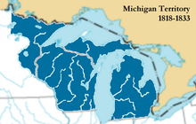
The Territory of Michigan was an organized incorporated territory of the United States that existed from June 30, 1805, until January 26, 1837, when the final extent of the territory was admitted to the Union as the State of Michigan. Detroit was the territorial capital.

The Territory of Wisconsin was an organized and incorporated territory of the United States that existed from July 3, 1836, until May 29, 1848, when an eastern portion of the territory was admitted to the Union as the State of Wisconsin. Belmont was initially chosen as the capital of the territory. In 1837, the territorial legislature met in Burlington, just north of the Skunk River on the Mississippi, which became part of the Iowa Territory in 1838. In that year, 1838, the territorial capital of Wisconsin was moved to Madison.
The Indiana Territory, officially the Territory of Indiana, was created by an organic act that President John Adams signed into law on May 7, 1800, to form an organized incorporated territory of the United States that existed from July 4, 1800, to December 11, 1816, when the remaining southeastern portion of the territory was admitted to the Union as the state of Indiana. The territory originally contained approximately 259,824 square miles (672,940 km2) of land, but its size was decreased when it was subdivided to create the Michigan Territory (1805) and the Illinois Territory (1809). The Indiana Territory was the first new territory created from lands of the Northwest Territory, which had been organized under the terms of the Northwest Ordinance of 1787. The territorial capital was the settlement around the old French fort of Vincennes on the Wabash River, until transferred to Corydon near the Ohio River in 1813.

The territory of the United States and its overseas possessions has evolved over time, from the colonial era to the present day. It includes formally organized territories, proposed and failed states, unrecognized breakaway states, international and interstate purchases, cessions, and land grants, and historical military departments and administrative districts. The last section lists informal regions from American vernacular geography known by popular nicknames and linked by geographical, cultural, or economic similarities, some of which are still in use today.

The Illinois Country — sometimes referred to as Upper Louisiana —was a vast region of New France claimed in the 1600s in what is now the Midwestern United States. While those names generally referred to the entire Upper Mississippi River watershed, French colonial settlement was concentrated along the Mississippi and Illinois Rivers in what is now the U.S. states of Illinois and Missouri, with outposts on the Wabash River in Indiana. Explored in 1673 from Green Bay to the Arkansas River by the Canadien expedition of Louis Jolliet and Jacques Marquette, the area was claimed by France. It was settled primarily from the Pays d'en Haut in the context of the fur trade, and in the establishment of missions from Canada by French Catholic religious orders. Over time, the fur trade took some French to the far reaches of the Rocky Mountains, especially along the branches of the broad Missouri River valley. The French name, Pays des Ilinois, means "Land of the Illinois [plural]" and is a reference to the Illinois Confederation, a group of related Algonquian native peoples.

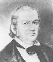
Ninian Edwards was an American political figure who was prominent in Illinois. He served as the first and only governor of the Illinois Territory from 1809 to until the territory earned statehood in 1818. He was then one of the first two United States senators from the State of Illinois from 1818 to 1824, and the third Governor of Illinois from 1826 to 1830. In a time and place where personal coalitions were more influential than parties, Edwards led one of the two main factions in frontier Illinois politics.

The Wea were a Miami-Illinois-speaking Native American tribe originally located in western Indiana. Historically, they were described as either being closely related to the Miami Tribe or a sub-tribe of Miami.
Shadrach Bond was a representative from the Illinois Territory to the United States Congress. In 1818, he was elected Governor of Illinois, becoming the new state's first chief executive. In an example of American politics during the Era of Good Feelings, Bond was elected to both positions without opposition.

The Treaty of St. Mary's may refer to one of six treaties concluded in fall of 1818 between the United States and Natives of central Indiana regarding purchase of Native land. The treaties were
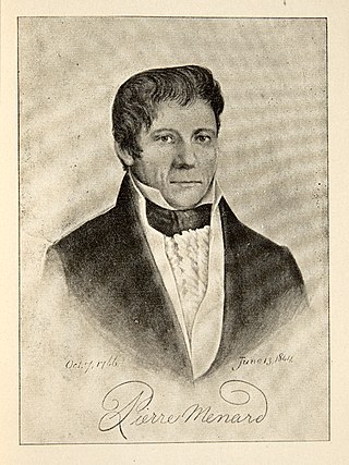
Pierre Menard was a Canadian-American fur trader and U.S.political figure, who was elected the first lieutenant Governor of Illinois in 1818.
Jesse Burgess Thomas was an American lawyer, judge and politician who served as a delegate from the Indiana Territory to the tenth Congress and later served as president of the Constitutional Convention which led to Illinois being admitted to the Union. He became one of Illinois' first two Senators, and is best known as the author of the Missouri Compromise of 1820. After his retirement from the U.S. Senate in 1829 he lived the rest of his life in Ohio.
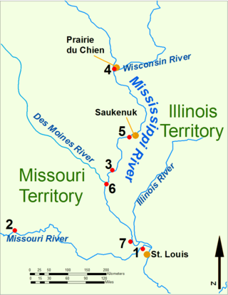
During the War of 1812, the Illinois Territory was the scene of fighting between Native Americans and United States soldiers and settlers. The Illinois Territory at that time included the areas of modern Illinois, Wisconsin and parts of Minnesota and Michigan.

Illinois Territory's at-large congressional district was a congressional district that encompassed the entire Illinois Territory. The territory was established on March 1, 1809 from portions of Indiana Territory. The district elected a non-voting delegate to the United States House of Representatives.
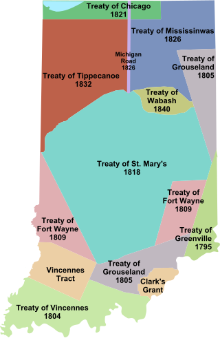
Indian removals in Indiana followed a series of the land cession treaties made between 1795 and 1846 that led to the removal of most of the native tribes from Indiana. Some of the removals occurred prior to 1830, but most took place between 1830 and 1846. The Lenape (Delaware), Piankashaw, Kickapoo, Wea, and Shawnee were removed in the 1820s and 1830s, but the Potawatomi and Miami removals in the 1830s and 1840s were more gradual and incomplete, and not all of Indiana's Native Americans voluntarily left the state. The most well-known resistance effort in Indiana was the forced removal of Chief Menominee and his Yellow River band of Potawatomi in what became known as the Potawatomi Trail of Death in 1838, in which 859 Potawatomi were removed to Kansas and at least forty died on the journey west. The Miami were the last to be removed from Indiana, but tribal leaders delayed the process until 1846. Many of the Miami were permitted to remain on land allotments guaranteed to them under the Treaty of St. Mary's (1818) and subsequent treaties.
Nathaniel Pope was an American government leader in the early history of the State of Illinois. He served as the Secretary of the Illinois Territory, then as a Delegate to the United States House of Representatives from the Illinois Territory, and for over thirty years as the United States district judge for the United States District Court for the District of Illinois.
Thomas Cox was an American pioneer, politician, and surveyor from what is now Kentucky. His family moved to the Indiana Territory, where Cox joined the territory militia. He was promoted to a lieutenant colonel and may have seen service in the War of 1812. After the war, he became a surveyor to help support his family. He also served in county politics until the state of Illinois was formed in 1818. Cox was elected to its 1st General Assembly as a state senator, serving for two years. He then worked as Register of the U.S. Land Office in Springfield, Illinois, but fell into debt after some poor land speculation deals.
The Illinois Intelligencer (1814–1832), was the first newspaper in Illinois. Founded by Kentucky native Matthew Duncan as the Illinois Herald in 1814, the printing offices were also used to print early territorial documents. In 1816, the operation was sold to Daniel Pope Cook, who re-titled the publication the Western Intelligencer. Under Robert Blackwell, Elijah C. Berry, and William C. Berry, the paper was issued until 1832.