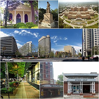
Bethesda is an unincorporated, census-designated place in southern Montgomery County, Maryland, United States, located just northwest of Washington, D.C. It takes its name from a local church, the Bethesda Meeting House, which in turn took its name from Jerusalem's Pool of Bethesda. The National Institutes of Health's main campus and the Walter Reed National Military Medical Center are in Bethesda, in addition to a number of corporate and government headquarters.

The Defense Intelligence Agency (DIA) is an intelligence agency of the United States federal government, specializing in defense and military intelligence.

Travilah is a United States census-designated place and an unincorporated area in Montgomery County, Maryland. It is 17.28 square miles (44.8 km2) located along the north side of the Potomac River, and surrounded by the communities of Potomac, North Potomac, and Darnestown—all census-designated places. It had a population of 11,985 as of the 2020 census.

The National Geospatial-Intelligence Agency (NGA) is a combat support agency within the United States Department of Defense whose primary mission is collecting, analyzing, and distributing geospatial intelligence (GEOINT) in support of national security. Initially known as the National Imagery and Mapping Agency (NIMA) from 1996 to 2003, it is one of the "big five" members of the United States Intelligence Community.

Washington College is a private liberal arts college in Chestertown, Maryland. Maryland granted Washington College its charter in 1782. George Washington supported the founding of the college by consenting to have the "College at Chester" named in his honor, through generous financial support, and through service on the college's Board of Visitors and Governors. Washington College is the 10th-oldest college in the United States and was the first college chartered after American independence. The school became coeducational in 1891.

Emory & Henry College is a private liberal arts college in Emory, Virginia. The campus comprises 335 acres (1.36 km2) of Washington County, which is part of the Appalachian highlands of Southwest Virginia. Founded in 1836, Emory & Henry College is the oldest institution of higher learning in Southwest Virginia.

The Walter Reed Army Medical Center (WRAMC) – known as Walter Reed General Hospital (WRGH) until 1951 – was the U.S. Army's flagship medical center from 1909 to 2011. Located on 113 acres (46 ha) in the District of Columbia, it served more than 150,000 active and retired personnel from all branches of the military. The center was named after Major Walter Reed (1851–1902), an Army physician who led the team that confirmed that yellow fever is transmitted by mosquitoes rather than direct contact.

The Washington Aqueduct is an aqueduct that provides the public water supply system serving Washington, D.C., and parts of its suburbs. One of the first major aqueduct projects in the United States, the Aqueduct was commissioned by Congress in 1852, and construction began in 1853 under the supervision of Montgomery C. Meigs and the US Army Corps of Engineers. Portions of the Aqueduct went online on January 3, 1859, and the full pipeline began operating in 1864. The system has been in continuous use ever since. It is listed as a National Historic Landmark, and the Union Arch Bridge within the system is listed as a Historic Civil Engineering Landmark.

Glen Echo Park is an arts and cultural center in Glen Echo, Maryland, a suburb of Washington, D.C. Located about 9 miles (14 km) northwest of the city's downtown area, the park's site was initially developed in 1891 as a National Chautauqua Assembly.

Dalecarlia Reservoir is the primary storage basin for drinking water in Washington, D.C., fed by an underground aqueduct in turn fed by low dams which divert portions of the Potomac River near Great Falls and Little Falls. The reservoir is located between Spring Valley and the Palisades, two neighborhoods in Northwest Washington, and Brookmont, a neighborhood in Montgomery County, Maryland.

The Capital Crescent Trail (CCT) is a 7.04-mile (11.33 km) long, shared-use rail trail that runs from Georgetown in Washington, D.C., to Bethesda, Maryland. An extension of the trail from Bethesda to Silver Spring along a route formerly known as the Georgetown Branch Trail is being built as part of the Purple Line light rail project.
National Park Seminary — later called National Park College — was a private girls' school open from 1894 to 1942. Located in Forest Glen Park, Maryland, its name alludes to nearby Rock Creek Park. The historic campus is to be preserved as the center of a new housing development.

The Walter Reed National Military Medical Center (WRNMMC), formerly known as the National Naval Medical Center and colloquially referred to as the Bethesda Naval Hospital, Walter Reed, or Navy Med, is a United States' tri-service military medical center, located in the community of Bethesda, Maryland, near the headquarters of the National Institutes of Health. It is one of the most prominent U.S. military medical centers in the Washington, D.C. metropolitan area and the United States, having served numerous U.S. presidents since the 20th century.
Lucien Emile "Lou" Conein was a French-American citizen, noted U.S. Army officer and OSS/CIA operative.

Little Falls Branch, a 3.8-mile-long (6.1 km) tributary stream of the Potomac River, is located in Montgomery County, Maryland. In the 19th century, the stream was also called Powder Mill Branch. It drains portions of Bethesda, Somerset, Friendship Heights, and the District of Columbia, flows under the Chesapeake and Ohio Canal (C&O), and empties into the Potomac at Little Falls rapids, which marks the upper end of the tidal Potomac.

The Old Naval Observatory is a historic site at 23rd and E Street in Northwest, Washington, D.C.. It is where the United States Naval Observatory was located from 1844 to 1893, when it moved to its present grounds. The original observatory building, built 1839-40, still stands, and is a designated National Historic Landmark. The Washington meridian of 1850 passes through the Observatory. The property for many years housed the Navy's Bureau of Medicine and Surgery, which moved out in 2012. The property has been taken over by the State Department.
Dorsey Hall is a historic home in Columbia, Maryland, United States. It is a six-by-one-bay, 2+1⁄2-story stucco structure with a gable roof covered with asphalt shingles. It is a well-preserved and detailed example of the vernacular dwellings of the early 19th century in Howard County and associated with the Dorsey family, one of the "first families" of the county.

Battery Cameron was a Union Army defensive site during the Civil War. Battery Cameron was one in a chain of fortifications in the Civil War Defenses of Washington, D.C., also known as the "Fort Circle". The battery was located atop a hill on Foxhall Road at what is now the intersection of Foxhall and Whitehaven Parkway, NW. The battery included two 100-pound Parrott rifles, placed in such a way as to sweep Aqueduct Bridge, and Virginia beyond.

Chevy Chase Elementary School is an elementary school containing grades 3–5 in Chevy Chase, Maryland. It was founded in 1917 in as the “Chevy Chase School” and for many years was known informally as the "Rosemary School" by reason of its location on Rosemary Street. The first building was erected in 1917. New structures were added in 1930 and 1936, and renovations were made over the years, most recently in 1999. Described as "an early example of school architecture that successfully combines both traditional and modern design elements", with "Art Deco geometric panels and stepped-up parapets [that] were modern for the era, yet ... tempered by classical door and window treatments", the school has been designated as an Historic Site by the Maryland Historical Trust. The school is also said to have had the first school library in the county, established in 1939.
Leslie Prince Raimond is Director Emeritus, Kent Cultural Alliance in Chestertown, MD.

